
The Fossil Forest of Axel Heiberg Island
By Tyler C. Cantwell
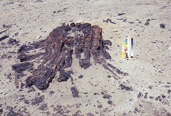
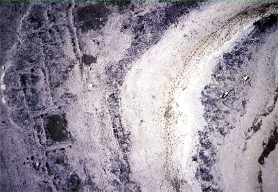
© Government of Canada, Canadian Conservation Institute. 77566-0003
Figure 1. Erosion of 40-million-year-old tree stump.
Early accounts of the fossil forest
On Axel Heiberg Island (ᐅᒥᖕᒪᑦ ᓄᓈᑦ) in the High Arctic, in what was formerly the Northwest Territories and is now Nunavut, a site of international significance sat largely unrecognized for decades. Indigenous peoples likely knew about the site for centuries. Early explorers in the 1800s observed the phenomenon, and a pilot flying on surveying work also spotted it from a helicopter in the mid-20th century (Strang 2022). However, it was not until 1985 that Dr. B.D. Ricketts of the Geological Survey of Canada documented the site’s significance (Grattan 1997).
Dr. Ricketts found that the site contained fossil remains of an in situ forest that was roughly 40 million years old. “In situ” means that the tree stumps still stood where the trees had been some 40 million years ago, and the forest floor of leaf litter, cones and seeds was preserved much like a still photograph of that time. This was a forest comprised predominantly of two types of trees: dawn redwood trees (Metasequoia), a species which today is native to the Hubei province of China (Grattan et al. 1996); and an extinct species of Pseudolarix trees, related to those trees which produced Baltic amber (Anderson and LePage, 1995). The tree stumps, leaves, seeds and cones were all in a remarkable state of preservation, creating a record of an ancient climatic warming period (Grattan 1997).
The fossil forest drew significant academic interest. Unfortunately, the name “fossil forest” can be misleading as the tree stumps, seeds, cones and leaf litter are more mummified than fossilized, with only 5% of the stumps being mineralized. Thus, it was soon discovered that removing specimens from the dry and frozen Arctic led to their quick degradation. Currently, the entire site faces the threat of degradation due to accelerated climate change. Ironically, it is erosion that led to the site’s formation through the accumulation of mud, which then became permafrost, and now it is erosion that threatens the site’s integrity.
CCI pioneers preservation techniques
In 1986, the Canadian Conservation Institute (CCI) became involved with the site when a fossil tree stump was brought to the National Museum of Natural Sciences (now the Canadian Museum of Nature) in Ottawa. Despite careful handling and packaging, upon arrival it was noted that the stump had cracks and had begun delaminating (a kind of fracturing). CCI worked to develop techniques to preserve the specimens retrieved from the site as well as to document and conserve the site itself. By injecting polyethylene glycol (PEG) into the specimen to prevent shrinkage and by freeze-drying it, conservation scientists at CCI successfully preserved the stump from further deterioration (Grattan et al. 1996).
Leaf, seed and cone fossils posed a greater challenge due to extreme fragility. It was essential that CCI preserve these specimens as they held great importance to paleobotanists (scientists who study fossilized plants). However, in 1986, there was no known conservation technique for materials of this nature. Thus, the conservators at CCI became pioneers in fossil leaf, seed and cone preservation when they successfully conducted a joint project with the Union Carbide Corporation to apply a Parylene coating to preserve the fossils without drastically altering their appearance (Grattan et al. 1996).
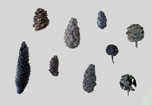
© Government of Canada, Canadian Conservation Institute. 77566-0007
Figure 2. Fossil forest cone collection after Parylene coating, photographed in studio at CCI.
The site itself also required considerable conservation attention. Erosion in the form of wind, frost and water threatened (and still threatens) the site year after year. Although abated by permafrost, winds of up to 90 km/h blow across the site, removing gravel and exposing fossil forest leaf litter. Deposits are often interrupted due to tundra polygons, which are cracks that fill with water and refreeze, creating a wedge of ice (Bigras et al. 1995). The spring thaw also causes the movement of water-saturated ground above the permafrost table.
Some of the worst damage to occur since Dr. Rickett’s trip has been caused by people. Footprints in the loose soil can persist for over a year in the High Arctic, and these footprints can act as catalysts for hillside erosion channels (Bigras et al. 1995). Excavation, although necessary to understand the site, is inherently destructive and can threaten other areas of the site if proper care is not taken (Bigras et al. 1995). Helicopters can cause significant damage to the site through strong downdrafts, destroying materials and blowing away topsoil. This is a significant threat, as the High Arctic often has a Canadian Armed Forces presence.
Both the towering Metasequoia and the Pseudolarix trees that grew in the forest more than 40 million years ago produced a special type of sap which, through intricate polymerization reactions, hardened and solidified as it seeped from the plants and was exposed to light and air. As the sap underwent millennia of aging, it fossilized and became amber. Amber at the site is present in different forms, nearly invisible and appearing as small, weathered pebbles in the exposed spaces of the forest and sparkling like fresh-cut gems when protected among the buried fossil leaf matter (Jahren 2017). Work performed by CCI scientists on many specimens discovered that the Pseudolarix trees produced amber that differed chemically from all other classes of amber previously characterized in the world. A new subclass (Class Id) was introduced to categorize them and was expanded to also included specimens from neighbouring Ellesmere Island (Poulin and Helwig 2012).
Unfortunately, in addition to academic visits by careful researchers, the site was also exposed to some looting, especially fruitless hunts for amber thanks to the release of Jurassic Park in 1993 (Strang 2022). The good intentions of just a few individuals have had a substantial impact on the protection of the site. Although the site was not under any form of protected status in 2012, Capt. Dean Campbell of the Canadian Armed Forces approached David W. Grattan at CCI and James Basinger at the University of Saskatchewan to ensure the area was listed as an exclusion zone for operations and personnel. It cannot be overstated how much the site may have been protected through this one act.
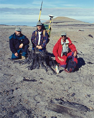
© Government of Canada, Canadian Conservation Institute. 77566-0010
Figure 3. Malcolm Bilz, Tom Strang and Carl Bigras with one of the exposed stumps.
The forces of erosion, especially when compounded, are significant. While working at the site in 1989, CCI’s Charles Gruchy noted in his journal that “…there must be fifty stumps there that weren’t visible last year.” (Gruchy 1990)
Thus, CCI set to work on documenting the site as quickly as possible. In 1995 and 1996, CCI staff members carried out global positioning system and geographic information system (GPS/GIS) surveying and kite aerial photography (KAP) to create an inventory of the approximately 1000 tree stumps at the site and to monitor erosion and visitor impact. There were several options for aerial photography, but logistical and fiscal constraints ruled out all but KAP. Carl Bigras offered the use of his own KAP equipment to ensure that the project could be completed within the limited budget.
Bigras consulted colleagues at CCI in furniture conservation (Michael Harrington and Paul Heinrichs) to build the camera platform for the kite out of extremely light balsa wood. Two Kodak Cameo cameras, which Bigras purchased himself, were installed on the kit with 60% overlap to achieve stereo photography (Bigras 1997). Given that there was no time to test the system beforehand, Bigras and the team had to trust in their capabilities and that the system would, indeed, work in the field.
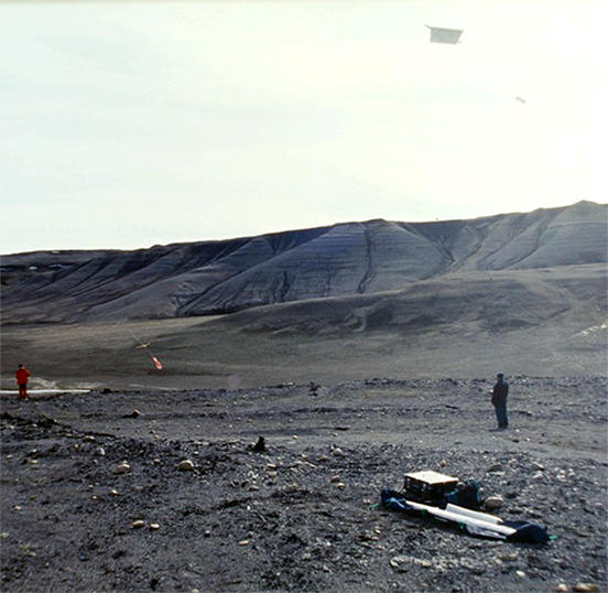
© Government of Canada, Canadian Conservation Institute. 77566-0012
Figure 4. Stereo camera rig in flight.
Inevitably, problems arose once in the field, but some quick ingenuity corrected the situation. This was imperative as the crew had limited time on site and often could not fly due to poor weather and heavy winds. One particular issue they encountered was that the kite blew from side to side without stabilizing and did not fly parallel to the ground, which was essential to take clear photographs of the topography. With a bit of duct tape, bamboo, cable ties and a Canadian flag windsock, the rig became stabilized in later flights (Bigras 1997). The project conducted by Bigras and his colleagues was successful. By overlaying their photos onto aerial photography conducted in 1989, researchers were able to evaluate erosion. After years of study, an average erosion rate of at least 3 mm per year was confirmed through the GPS/GIS work of Tom Strang and David W. Grattan in 1995 and again in 1996 (Bigras et al. 1995).
© Government of Canada, Canadian Conservation Institute. 77566-0013
Figure 5. KAP image results which could be overlaid onto previous aerial images to document erosion and other changes in the landscape. Tundra polygons are easily visible on the left-hand side, in a checkered pattern.
Life at the fossil forest: an interview with Tom Strang
I interviewed Senior Conservation Scientist Tom Strang to find out more about his experiences on Axel Heiberg Island. Tom began working for CCI in 1988 and took his first trip to the fossil forest in 1995 when Chuck Gruchy was unable to go at the last moment. Tom told me how happy he was to find himself in this new environment and remembered heavy wet snow falling on him as he deployed cutting-edge technology.
At the time, digital GPS/GIS was very new in the realm of conservation, and Tom pitched the idea of using digital survey GPS and GIS at the fossil forest site. Tom was successful in convincing his superiors of their value and began renting the required gear, including several buckets’ worth of rechargeable batteries. An introductory course held in a parking lot and a few stacks of manuals later, Tom was ready for the trip, along with David W. Grattan.
David and Tom flew from Ottawa to Resolute (ᖃᐅᓱᐃᑦᑐᖅ), Northwest Territories (now Nunavut), where the Polar Continental Shelf Project (PCSP) outfitted them with food and supplies. They filled their lunch bags with Nanaimo bars from the PCSP facility and watched as their campsite materials were put into a front-end loader bucket and driven over to a waiting Twin Otter for their ride directly to the fossil site. After two hours of flying over islands ringed with arctic ice and then landing on rocky tundra near a twisting streambed, they unloaded their supplies. As the hum of the aircraft engines faded away, leaving the two men alone on the island, Tom heard another sound like a low rumble. After a moment, he realized it was his own heartbeat he could hear cutting through the silence of the High Arctic.
The trip’s primary goal was the removal of rebar erosion measurement stakes, which were becoming a potential hazard to landing helicopters. As David moved about the hill removing the stakes, Tom took GPS/GIS readings in his wake. The speed at which the GPS/GIS system was able to survey the site left David astounded. However, the 1995 trip was marked by poor weather. Snow and wind cut the trip short. Tom knew he needed to return the following year.
In July 1996, Tom returned to Axel Heiberg Island with Carl Bigras and Malcom Bilz. The flight north to Resolute was cloudy, so Tom took the time to review the GPS/GIS manuals and the surveying plan. After flying by Twin Otter from Resolute to Eureka on Ellesmere Island, Tom, Carl and Malcolm headed off to meet with the pilot who would be taking them to Axel Heiberg Island. The trio walked right past the helicopter, which was missing the tail rotor. As they entered the PCSP facility, Tom noticed a warning poster depicting a cartoon decapitation by a helicopter rotor. The text on the sign read: “Rotors Are Expensive.”
When they entered the living quarters, Tom saw the mechanic first. He was a young man wearing silver sunglasses. Pieces of the tail rotor lay scattered on the table, and he had repair manuals spread out around him. The mechanic indicated that the pilot was in the other room, where they heard someone laughing at Bugs Bunny on the television. Tom was not confident that they would fly the next day. However, soon after, the trio successfully made their way to Axel Heiberg by a series of flights with sling loads full of gear.
The three men stood still for a time, observing the landscape and “taking it all in like the muskox,” Tom told me. The team then set up their camp, starting with the radio mast and check-in. The PCSP, who had helped to arrange their transportation, had also provided tents and much of their supplies. In addition to these items, they also had the leased GPS/GIS equipment, the KAP equipment, a solar panel for charging the equipment, a radio and the CCI shotgun, which was required in the isolated northern region to protect themselves from polar bears.
Despite being alone on the island, it often felt as though the trio had company. At the time, the Canadian military was busy cleaning the Arctic, collecting old oil supply tanks and drums that had been left scattered about from activities decades past. Much chatter could also be heard over the radio. One conversation that was overheard was an individual complaining that a pump handle for a hot water shower was not on site and needed to be on the next flight in. The trio found this darkly comical as they bathed using cold water from the stream.
As the trio set to work, they never strayed too far from camp and the fossil forest hill. Tom likened this to landing on the moon. “You never want to let the spacecraft out of your sight,” he said. The region was colloquially referred to as the “starvation coast,” after all, and the weather was unpredictable.
Tom was using a Trimble Navigation 4000SSi with real-time kinematic (RTK) functions, a GPS surveying system that had a stationary horizontal resolution of 1 cm and a vertical resolution of 2 cm (Strang 1997). Even while walking, Tom could record positions with a 4–6 cm resolution both vertically and horizontally (Strang 1997).
Using data from prior surveys merged with the GPS data that Tom had collected the previous year and uploaded to the laptop computer, he and Malcolm could easily locate previously identified features and document new ones (Strang 1997). The data Tom generated was later overlaid onto the aerial photography and its digital elevation model, produced by The Base Mapping Co., to create an incredibly comprehensive and detailed representation of the site.
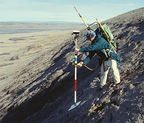
© Government of Canada, Canadian Conservation Institute. 77566-0029
Figure 6. Tom Strang with the GPS mapping system on the north side of the fossil forest.
The state of the fossil forest today
Over the years of study and surveying, several stumps have seemingly disappeared. In 1992, 62 stumps that had been recorded in 1988 could no longer be located. CCI staff guessed that surface sediment could have moved and concealed the stumps again (Bigras et al. 1995).
Another possibility is that unknown visitors to the site had removed or destroyed stumps. Indeed, around 1999, a team led by Arthur H. Johnson from the University of Pennsylvania, with researchers from Johns Hopkins University and the University of Maine—unbeknownst to those at CCI who had been working on preserving the site for years—received a research licence from the Nunavut Research Institute and approval from the Canadian federal government (through PCSP) to extensively excavate the site with chain saws and trenches several metres long. They carried away large blocks of wood. The full extent of the losses to the site has not yet been determined.
Similarly, cruise ships in the Arctic made Axel Heiberg a must-see stop and ferried tourists to the island. Many tourists took “souvenirs” away from the site. In 1992, Bigras and his colleagues stressed the need to protect the site through its incorporation into the Canadian Parks Service, possibly through an annex to Ellesmere Island National Park Reserve (now known as Quttinirpaaq National Park) (Bigras et al. 1992). Several members of CCI worked diligently, many throughout their careers, to conserve and protect this site of both Canadian and international significance.
Arthur H. Johnson, the project leader of the excavation headed by the University of Pennsylvania in the late 1990s, had this to say while fielding criticism and scrutiny from Canadian researchers and journalists: “Some people think that this place is sacred; others want it for a picnic spot. We think it’s a scientific resource…. Maybe it’s good if Canadians decide what they want to do with it.” (George 1999)
When the COVID-19 pandemic comes to an end and life returns to normal, cruise ships and visitors to the site are sure to increase once again. After Strang, Bilz and Bigras’ trip in 1996, CCI has never returned to the fossil forest site despite intentions to do so to conduct a larger area erosion study. Thus, the state of the site today is largely unknown.
Tom Strang summarized CCI’s involvement with the fossil forest site in a 1997 article for the CCI Newsletter:
Initially intended as a study in natural loss, the focus of CCI’s involvement has changed somewhat because ease of access and fame have drawn many visitors to the fossil forest, some of whose actions have damaged this site. Ultimately, CCI’s map and photographs will contribute to a site management plan and to the efforts toward attaining protected status for the site. An information pamphlet will be produced by CCI that can be used by helicopter pilots to avoid landing on the often difficult-to-see stumps and by visitors to avoid trampling sensitive features or creating erosion gullies. Above all, creating the most complete and accurate record of this site has allowed CCI to establish a thorough, long-term study of site use and abuse for one of the most sensitive environments on Earth.
At the time of writing, the site is still not protected.
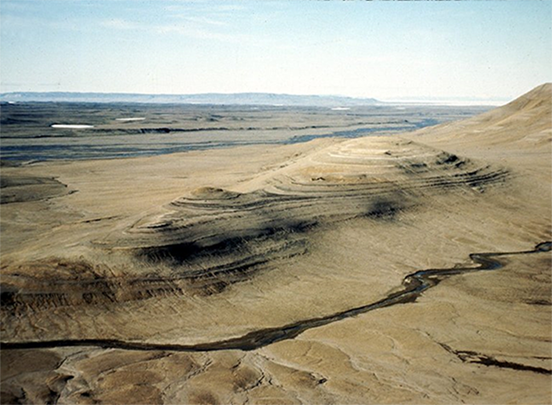
© Government of Canada, Canadian Conservation Institute. 77566-0008
Figure 7. Northeastern view of the fossil forest site shot from the south mountain in 1996.
Bibliography
Anderson, K.B., and B.A. LePage. “Analysis of Fossil Resins from Axel Heiberg Island, Canadian Arctic.” In K.B. Anderson and J.C. Crelling, eds., Amber, Resinite, and Fossil Resins, vol. 617 (May 1996). Washington, D.C.: American Chemical Society Symposium, pp. 170–192.
Bigras, C. “Kite Aerial Photography of the Axel Heiberg Island Fossil Forest.” In M. Bauer, W. Befort, P.R. Coppin and B. Huberty, eds., Proceedings of the First North American Symposium on Small Format Aerial Photography, Cloquet, Minnesota, 14–17 October 1997: Technical Papers. Bethesda, Maryland: American Society for Photogrammetry and Remote Sensing, 1997, pp. 147–153.
Bigras, C., M. Bilz, D.W. Grattan and C. Gruchy. “Erosion of the Geodetic Hills Fossil Forest, Axel Heiberg Island, Northwest Territories.” Arctic 48,4 (December 1995), pp. 342–353.
George, J. “Arctic Fossil Forest Sparks U.S.–Canada Research War.” Nunatsiaq News, July 23, 1999.
Grattan, D.W. “Fossil Forest” (PDF format). New Parks North Newsletter 6 (March 1997), p. 12.
Grattan, D.W., C. Gruchy, M. Bilz and C. Bigras. “The Fossil Forest Project at the Canadian Conservation Institute.” In J. Bridgland, ed., ICOM-CC, 11th Triennial Meeting, Edinburgh, Scotland, 1–6 September 1996: Preprints, vol. 2. London, UK: James & James, 1996, pp. 776–783.
Gruchy, C. “The Fossil Forest on Axel Heiberg Island.” CCI Newsletter 6 (September 1990), pp. 5–6.
Jahren, H. Lab Girl. Toronto, ON: Penguin Random House Canada Limited, 2017, pp. 194–201.
Poulin, J., and K. Helwig. “Class Id Resinite from Canada: A New Sub-Class Containing Succinic Acid.” Organic Geochemistry 44 (March 2012), pp. 37–44.
Strang, T. “Global Positioning Survey of the Fossil Forest in the Canadian High Arctic.” CCI Newsletter 19 (March 1997), pp. 1–3.
Strang, T. Interview. Conducted by T.C. Cantwell, May 19, 2022.
© Government of Canada, Canadian Conservation Institute, 2023
Cat. No.: CH57-4/67-2023E-PDF
ISBN 978-0-660-49168-4