
What We Heard Report
Table of Contents
1. Executive Summary of A-OTHR Consultation
Since July 17, 2025, the Department of National Defence (DND) has been conducting public consultations on Stage 1 of the Arctic Over-the-Horizon Radar (A-OTHR) program. These consultations have included an online feedback form hosted on a dedicated A-OTHR program engagement website, as well as a series of town hall information sessions held near the two Stage 1 sites in Kawartha Lakes and Clearview Township.
In addition to these planned outreach activities, DND has received approximately 25 unsolicited letters and email submissions from community associations, agricultural organizations, local businesses, and residents. These communications often raised questions and concerns about the A-OTHR program. Where possible, DND provided responses, recognizing that many inquiries relate to aspects of the program that remain under development.
The A-OTHR consultation process has seen strong engagement from the public. Town Hall sessions averaged 240 participants per session (in-person and virtual attendance combined), and over 400 online feedback forms were received. This demonstrates a high level of interest from both local communities and individuals across Canada.
While some submissions expressed support for the A-OTHR program and its contribution to Canada’s domain awareness, the majority of feedback voiced opposition, particularly regarding the potential use of agricultural lands for future Stage 2 receive sites (Rx1 and Rx2) in Clearview Township.
The most frequently raised concerns—as expressed in the online feedback forms, letters, emails, and town hall information sessions—were the health and safety of nearby residents, environmental impacts, and potential effects on property values. In addition, local amateur radio operators and small aircraft pilots voiced concerns about whether their activities could continue alongside the A-OTHR system.
DND has actively incorporated community feedback into its ongoing planning and analysis. Engagement with small aircraft pilots has helped identify local flight paths and informed the development of potential airspace restrictions around the sites. Discussions with neighbouring landowners have supported assessments of nearby land uses—such as wind turbines—that could affect A-OTHR operations, helping to minimize potential disruptions. Feedback gathered during town hall sessions has guided the addition of supplemental information to the A-OTHR website to address common questions. These insights are also informing the siting analysis for Stage 2 receive sites and contributing to the development of concept designs and potential mitigation measures.
DND remains committed to transparency and ongoing dialogue with the public. Public feedback will inform where and how A-OTHR sites are developed, e.g., letters opposing the use of prime agricultural land will inform the Stage 2 siting decision, perimeter lighting will be designed to minimize light pollution, etc. Program updates will continue to be shared on the A-OTHR public webpage as they become available. Additional public engagement opportunities will be identified and communicated as the program advances.
2. A-OTHR Online Consultation
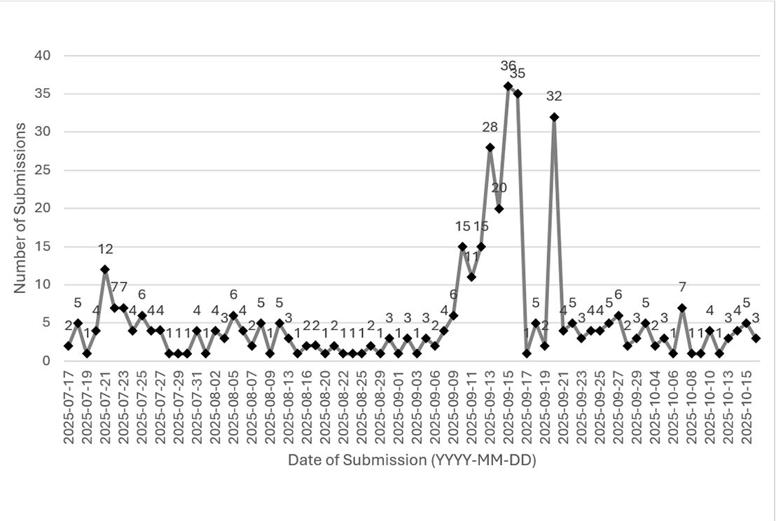
DND launched the A-OTHR online consultation period on July 17, 2025, coinciding with the public announcement of the selected Stage 1 transmit and receive sites for the A-OTHR program. Initially scheduled to conclude on September 15, 2025, the consultation period was extended by one month due to a surge in responses following the town hall information sessions, as illustrated in Figure 1. By the final closing date of October 15, 2025, a total of 410 feedback forms were received, averaging 5.4 responses per day.
Figure 1: A-OTHR Feedback Form Submissions per day
Caption
| Date of Submission | Number of Submissions |
|---|---|
| 2025-07-17 | 2 |
| 2025-07-18 | 5 |
| 2025-07-19 | 1 |
| 2025-07-20 | 4 |
| 2025-07-21 | 12 |
| 2025-07-22 | 7 |
| 2025-07-23 | 7 |
| 2025-07-24 | 4 |
| 2025-07-25 | 6 |
| 2025-07-26 | 4 |
| 2025-07-27 | 4 |
| 2025-07-28 | 1 |
| 2025-07-29 | 1 |
| 2025-07-30 | 1 |
| 2025-07-31 | 4 |
| 2025-08-01 | 1 |
| 2025-08-02 | 4 |
| 2025-08-04 | 3 |
| 2025-08-05 | 6 |
| 2025-08-06 | 4 |
| 2025-08-07 | 2 |
| 2025-08-08 | 5 |
| 2025-08-09 | 1 |
| 2025-08-11 | 5 |
| 2025-08-13 | 3 |
| 2025-08-15 | 1 |
| 2025-08-16 | 2 |
| 2025-08-19 | 2 |
| 2025-08-20 | 1 |
| 2025-08-21 | 2 |
| 2025-08-22 | 1 |
| 2025-08-23 | 1 |
| 2025-08-25 | 1 |
| 2025-08-26 | 2 |
| 2025-08-29 | 1 |
| 2025-08-31 | 3 |
| 2025-09-01 | 1 |
| 2025-09-02 | 3 |
| 2025-09-03 | 1 |
| 2025-09-05 | 3 |
| 2025-09-06 | 2 |
| 2025-09-08 | 4 |
| 2025-09-09 | 6 |
| 2025-09-10 | 15 |
| 2025-09-11 | 11 |
| 2025-09-12 | 15 |
| 2025-09-13 | 28 |
| 2025-09-14 | 20 |
| 2025-09-15 | 36 |
| 2025-09-16 | 35 |
| 2025-09-17 | 1 |
| 2025-09-18 | 5 |
| 2025-09-19 | 2 |
| 2025-09-20 | 32 |
| 2025-09-21 | 4 |
| 2025-09-22 | 5 |
| 2025-09-23 | 3 |
| 2025-09-24 | 4 |
| 2025-09-25 | 4 |
| 2025-09-26 | 5 |
| 2025-09-27 | 6 |
| 2025-09-28 | 2 |
| 2025-09-29 | 3 |
| 2025-10-01 | 5 |
| 2025-10-04 | 2 |
| 2025-10-05 | 3 |
| 2025-10-06 | 1 |
| 2025-10-07 | 7 |
| 2025-10-08 | 1 |
| 2025-10-09 | 1 |
| 2025-10-10 | 4 |
| 2025-10-12 | 1 |
| 2025-10-13 | 3 |
| 2025-10-14 | 4 |
| 2025-10-15 | 5 |
| 2025-10-16 | 3 |
Geographic distribution of respondents
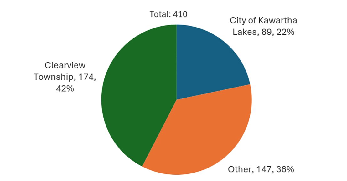
Respondents represented a diverse geographic range. Of the 410 responses, 174 individuals identified as residents of Clearview Township, 89 as residents of Kawartha Lakes, and 147 as residing elsewhere, as shown in Figure 2.
Figure 2: Residence of Respondents
Caption
| Residence | Number of Submissions | Distribution |
|---|---|---|
| City of Kawartha Lakes | 89 | 22% |
| Other | 147 | 36% |
| Clearview Township | 174 | 42% |
Key Themes
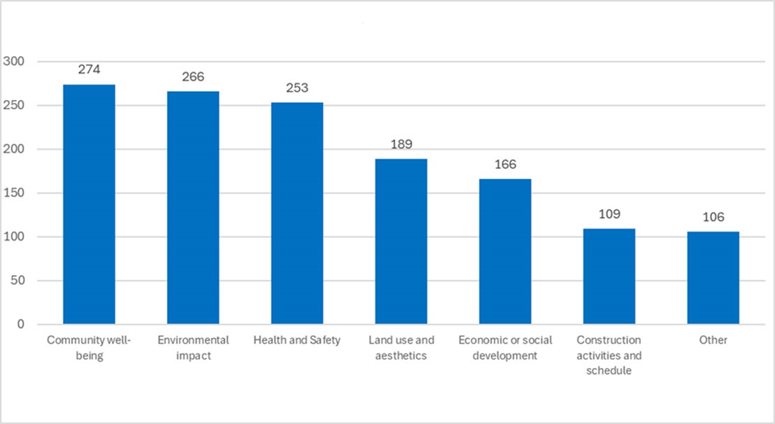
Six areas of interest anticipated as being most relevant to respondents were added to the feedback form, as illustrated in Figure 3.
Figure 3: Areas of Interest
Caption
| Areas of Interest | Number of selections |
|---|---|
| Community well-being | 274 |
| Environmental impact | 266 |
| Health and Safety | 253 |
| Land use and aesthetics | 189 |
| Economic or social development | 166 |
| Construction activities and schedule | 109 |
| Other | 106 |
The consultation highlighted several recurring themes raised by respondents, which are summarized below.
Community well-being:
Community well-being emerged as a key theme. Some respondents expressed that the installation of A-OTHR nearby could potentially position their communities as strategic defence locations, thereby increasing their visibility and vulnerability in the event of conflict. Additionally, there was widespread apprehension about the possibility of land acquisition by DND to support future A-OTHR site development.
Health and Safety:
Health and safety considerations were among the most frequently cited concerns. A significant number of respondents raised questions about the potential health effects of radiofrequency radiation emitted by the radar systems. This included skepticism toward Health Canada’s Safety Code 6, with some suggesting it may not reflect the most current scientific research. Specific concerns were raised about cancer risks, groundwater contamination, and impacts on individuals who identify as having Electromagnetic Hypersensitivity and live near the sites.
Particular attention was drawn to the phrasing on the A-OTHR webpage stating “there are no known health effects,” which some interpreted as implying the possibility of unexamined or undisclosed risks. Additional concerns were noted regarding the potential impact of construction activities on local waterways, including risks related to flooding and groundwater contamination.
Environmental Impact:
In Clearview Township, respondents expressed concern that A-OTHR could affect the Minesing Wetlands—a provincially protected and ecologically significant area governed by the Nottawasaga Valley Conservation Authority. In Kawartha Lakes, feedback focused on the potential disruption of bird nesting grounds and broader ecological systems. The location of the transmit site in the Carden Alvar Important Bird Area, which is home to several species at risk, raised concerns about the potential effects of radiofrequency emissions on avian and insect populations.
Cultural or Historical Significance:
In Clearview Township, respondents expressed concern that the development of additional land for a permanent receive site could lead to the loss of farmland, with implications for the region’s agricultural heritage. Some comments also reflected apprehension about potential demographic changes associated with an increased presence of military personnel, which some felt could alter the character of their communities. Additional concerns were raised about the risk of disturbing Indigenous burial grounds and damaging historically significant artifacts during excavation and construction activities.
Economic or Social Development:
In terms of economic or social development, many respondents expressed concern about potential declines in property values near the A-OTHR sites. These concerns were attributed to perceived health risks, aesthetic considerations, and uncertainty surrounding potential land acquisition, which could influence buyer interest. Conversely, some respondents expressed interest in the potential economic benefits of the program, including job creation, opportunities for local contractors, and possible financial contributions to municipal infrastructure through DND remittances.
Construction Activities and Schedule:
Concerns regarding construction activities and scheduling were also raised. Residents living near the proposed sites requested greater transparency around construction timelines and logistics. Specific concerns were noted regarding safety risks associated with heavy equipment traffic, particularly in areas frequented by children, such as bus stops.
Land Use and Aesthetics:
With respect to land use and aesthetics, respondents expressed concern about the visual impact of the radar infrastructure, describing the anticipated presence of large antenna arrays as visually unappealing. Light pollution was also mentioned, particularly its effect on visibility of the night sky. Additionally, questions were raised about the divestiture process in the event that the A-OTHR infrastructure is decommissioned.
Other:
Other concerns covered a range of additional topics. Some respondents questioned the selection of southern Ontario for the A-OTHR location, particularly the use of prime agricultural land, and suggested that more remote or less economically intensive areas, such as existing military properties like CFB Borden, might be more appropriate. Others expressed a desire for greater clarity regarding land acquisition processes, including whether DND intends to expropriate land, how residents might sell their property to DND, and whether continued investment in affected properties is advisable.
Many respondents raised questions about whether the radiofrequency emissions would interfere with existing radio-based services such as wireless internet, cellular networks, and amateur radio operations. Speculative concerns were also noted regarding the radar system’s potential influence on weather patterns, whether intentional or inadvertent.
3. Kawartha Lakes Public Engagement Sessions
Two public engagement sessions took place in the City of Kawartha Lakes on September 9, 2025, at the Coboconk Community Centre, one at 2:00 pm EDT and another at 7:00 pm EDT. Both sessions were well attended, with approximately 115 in-person attendees and 110 online participants at the afternoon session, and 120 in-person attendees and 75 online participants in the evening.
Mayor Doug Elmslie made opening remarks, and Councillor Emmett Yeo was also in attendance.
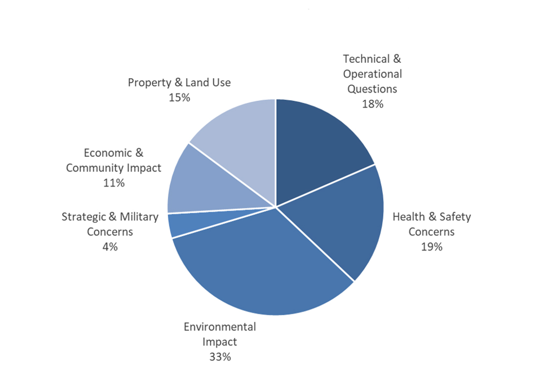
Questions raised during the sessions have been categorized into six themes: Environmental Impact, Health and Safety, Land Use and Property Rights, Transparency and Governance, Technical and Operational Details, and Community Benefits and Local Impact. A breakdown of these questions is presented in Figure 4 and Figure 5, with a more detailed overview available in Annex A – Kawartha Lakes Town Hall Q&A Summary 2pm EST 9 September 2025 and Annex B – Kawartha Lakes Town Hall Q&A Summary 7pm EST 9 September 2025.
Figure 4: Kawartha Lakes 2pm Session - Questions per Category
Caption
| Category | Distribution of Questions |
|---|---|
| Environmental Impact | 33% |
| Health & Safety Concerns | 19% |
| Technical & Operational Questions | 18% |
| Property & Land Use | 15% |
| Economic & Community Impact | 11% |
| Strategic & Military Concerns | 4% |
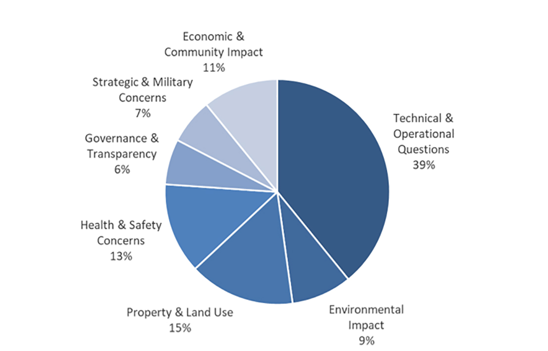
Figure 5: Kawartha Lakes 7pm Session - Questions per Category
Caption
| Category | Distribution of Questions |
|---|---|
| Technical & Operational Questions | 39% |
| Property & Land Use | 15% |
| Health & Safety Concerns | 13% |
| Economic & Community Impact | 11% |
| Environmental Impact | 9% |
| Strategic & Military Concerns | 7% |
| Governance & Transparency | 6% |
Annex A - Kawartha Lakes Town Hall Presentation
Presentation from the 2:00 p.m. EDT and 7:00 p.m. EDT public engagement sessions held on September 9, 2025, in Coboconk, ON
1. Context
1.1 - NORAD Modernization
- The North American Aerospace Defense Command (NORAD) is a binational military command between Canada and The United States (U.S.) responsible for aerospace warning, aerospace control, and maritime warning in defence of North America.
- There is a pressing need to modernize Canada’s NORAD capabilities in the context of the rapidly evolving global security environment.
- In June 2022, the Minister of National Defence announced Canada’s plan to enhance our contribution to NORAD with a total funding of $38.6 billion over twenty years.
- NORAD modernization is an important step in addressing Canada’s renewed requirements to strengthen the all-domain defence of Canada and North America.
1.2 - Why does Canada need an OTHR system?
- The existing North Warning System (NWS) was established in the 1980s and has not kept pace with new and emerging threats such as hypersonic weapons and advanced cruise missiles.
- As part of Canada’s NORAD modernization plan, DND is investing in a new Northern Approaches Surveillance System (NASS) to significantly expand NORAD and the CAF’s situational awareness of objects approaching and entering Canadian airspace from the North. NASS will include an Arctic Over-the-Horizon Radar (A-OTHR) system that will provide early warning radar coverage and threat tracking.
- The A-OTHR capability will be located in Southern Ontario and will extend NORAD and the Canadian Armed Forces’ (CAF) situational awareness into the Canadian North and the North Atlantic.
1.3 - Why does the A-OTHR need to be located in Southern Ontario?
- Over-the-Horizon Radar has the ability to conduct surveillance at far greater ranges than regular radar technology as it bounces radar beams off the ionosphere to see around the curvature of the Earth (see figure).
- The A-OTHR capability will be in Southern Ontario and will extend NORAD and the CAF's situational awareness into the Canadian North and the North Atlantic.
- It might seem strange that a radar built to watch Canada’s far north is placed in one of the country’s busiest regions. The reason is how the system works. A-OTHR uses the ionosphere to bounce signals beyond the horizon, letting it detect objects thousands of kilometers away. This works because the radar beams curve around the Earth (see figure 1).
- For the system to work well, the signal’s bounce point must stay outside the auroral zone, where the Northern Lights interfere with radar performance.
- The optimal latitude for achieving full coverage of Canada’s northern approaches—and especially the critical northeast corridor—runs through Southern Ontario. This location ensures maximum range and reliability.
- Over-the-Horizon Radar can conduct surveillance at far greater ranges than regular radar technology as it bounces radar beams off the ionosphere to see around the curvature of the Earth (see figure 1 below).
- The A-OTHR system needs to be in Southern Ontario to meet NORAD surveillance requirements.
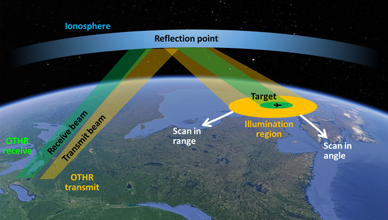
Caption
Illustration of the process through which the Arctic Over-the-Horizon Radar (A-OTHR) reflects radio waves to observe targets up to 3000 km away. The transmit beam travels from Earth, reflects off the ionosphere, and reaches a target area (aircraft, missiles or surface vessels) within the 'Illumination region.' The receive beam returns from the target via the ionosphere. The ionosphere is a curved layer above Earth.
1.4 - Staged implementation approach
- The Department of National Defence (DND) is taking a staged approach to advance the A-OTHR program.
- The full A-OTHR capability will consist of four antenna farms (two transmit and two receive sites) and some supporting infrastructure.
- Stage 1 will install a full-sized permanent transmitter in Kawartha Lakes, Ontario, and a preliminary receiver in Clearview Township, Ontario, that will deliver initial, limited radar capabilities earlier than the full capability of the four sites.
- Radar coverage will expand across future stages based on Stage 1 performance and in response to Canada’s defence needs.

Caption
A-OTHR Stage 1
- Permanent transmit site (Tx1) in Kawartha Lakes, Ontario.
- Preliminary receive site (Rx0.5) in Clearview Township, Ontario.

Caption
A-OTHR End-Stage
- Permanent transmit site (Tx1) in Kawartha Lakes, Ontario.
- Second permanent transmit site (Tx2), location to be determined (TBD).
- Two permanent receive sites (Rx1 and Rx2), location TBD.
2. Siting
2.1 - Siting analysis
- In July 2023, prior to acquiring the Kawartha Lakes and Clearview Township sites, Public Services and Procurement Canada posted a notice on CanadaBuys and in community newspapers to inform property owners of DND’s interest to buy land in southern Ontario. Property owners had until August 31, 2023, to confirm their interest with PSPC.
- In addition, DND reached out to private landowners, Indigenous communities, other federal government departments, and the Province of Ontario to assess A-OTHR siting opportunities.
- The siting options that arose out of these discussions were deemed to be unsuitable for the program and DND proceeded with the purchase of privately owned land parcels listed on the open market for use as a transmit site (0 Thistle Trail, Kawartha Lakes, Ontario) and a preliminary receive site (2225 Sideroad 15 & 16, Clearview Township, Ontario).
2.2 - Kawartha Lakes, Ontario, transmit site

Caption
An aerial view outlining the site located at 0 Thistle Trail, in Kawartha Lakes, Ontario. It is bordered by a road running north-south called Thistle Trail, another road east-west called County Road 41 which also runs north-south. Honeysuckle Road, running east-west intersects with Thistle Trail. Located north of Duck Lake. There are rural residential and agricultural lands surrounding the site.
Site information
- 163-hectares of vacant property comprised of a mix of pastureland, forest, and marsh lands.
- At the time of acquisition, the lands were actively used for cattle grazing.
- The property contains some wetlands and wooded areas located throughout the site.
- Observed wildlife includes various mammal, bird, reptile, and amphibian species, including federally and provincially listed Species at Risk.
- Surrounding lands consist of rural residential and agricultural uses.
- Development on nearby lands must be compatible with radar operations. This may restrict how surrounding land is used in the future.
2.3 - Where will the other A-OTHR sites be located?
- DND continues to assess options for the remaining permanent transmit site and two permanent receive sites.
- The remaining sites will be parcels of land ranging in size from 100 hectares to 1,200 hectares and will be located south of the 46th parallel north. As a frame of reference, this latitude roughly aligns with the Trans-Canada Highway within the provincial border of Ontario.
3. Implementation
3.1 - What will the A-OTHR look like?
- Land preparation will be required for each location. Required site works will include flattening of the land and removal of any obstructions that would impede the radar’s signal, including clearing of forested areas or filling of wetlands.
- The transmit sites will have a radiation hazard zone entirely contained within the site and be fenced to prevent access.
- While specific infrastructure needs are being finalized, the A-OTHR system will require supporting infrastructure at each site:
- Operations building
- Physical security features (e.g. fencing, patrol roads, gatehouse)
- Vehicle maintenance and storage facility
- Access road and parking
- Utilities (power, water, wastewater, stormwater, communications)
3.2 - Images of an OTHR (Australian example, for illustrative purposes)
Receive site (6m tall)
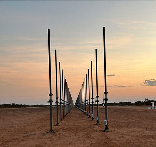
Caption
Two parallel rows of metallic posts anchored in the ground.
Transmit site (up to 45m tall)
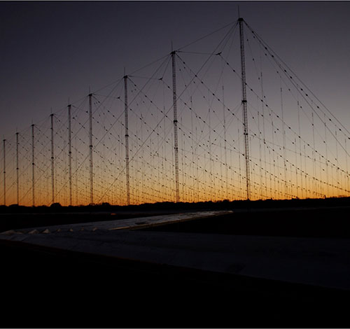
Caption
An antenna array featuring multiple rows of metallic poles of varying height anchored in the ground, tethered by wires.
Note: the Canadian A-OTHR capability will be modified to meet Canada's environment and operational needs (e.g. different number of antennas, etc.)
3.3 - Site studies
- Completed:
- An assessment of watercourse and wetlands within or in proximity to the site that may be impacted by the program, including aspects such as stormwater management and flooding/erosion prevention measures.
- A Flora and Fauna assessment to determine a baseline that includes migratory birds, at risk wildlife (legislated both federally and provincially), and identification of habitat types in the program area and surroundings.
- Stage 1 Archeological Overview Assessment of the area’s potential to contain valuable artifacts, structures, and evidence of Indigenous utilization.
- Ongoing:
- Stage 2, 3 and 4 (as needed) Archeological Overview Assessment including test pits, site excavation, and evaluation and conservation of archeological resources.
- Environmental Effects Determination (under the Impact Assessment Act) to identify potential adverse environmental impacts and associated mitigation measures (e.g. restoration, offsetting or compensation for loss of vegetation, post-construction monitoring program, etc).
- Application for Environment and Climate Change Canada and Department of Fisheries and Oceans permits prior to any work affecting species at risk, as required.
- Stage 2 Archeological Overview Assessment findings to date:
- Archeological sites have been identified at the Thistle site, including Indigenous and historical archeological resources.
- Stage 2 archaeological investigation is ongoing, followed by Stage 3 & 4 assessments as required.

Caption
Several fragments of pottery excavated on site, beige in colour and measuring between two and four centimeters in diameter.

Caption
A contractor conducting archeological field work in one of the identified sites, a square hole approximately six inches in depth with a surface area of approximately nine square feet.
Flora and Fauna assessments identified the following Species at Risk within the Thistle site:
- Flora
- Butternut
- Black Ash
- Fauna
- Western Chorus Frog
- Midland Painted Turtle
- Loggerhead Shrike
- Eastern Wood-pewee
- Eastern Meadowlark
- Grasshopper Sparrow
- Golden-winged Warbler
- Eastern Whip-poor-will
- Common Nighthawk
- Wood Thrush
- Little Brown Myotis
- Northern Myotis
- Tri-colored Bat
- Eastern Red Bat
- Hoary Bat
- Silver-haired Bat
3.4 - Are there any health and safety concerns?
- The areas surrounding the sites will comply with the national safety standards established by Health Canada regarding human exposure to radiofrequency electromagnetic fields.
- Fencing will be installed around the sites to ensure the public is not exposed to potential hazards.
- For the transmit sites, at ground level, beyond the perimeter fence, there are no known adverse human health effects associated with this type of technology.
- There are no known adverse human health effects associated with the receive sites.
3.5 - Stage 1 milestone schedule

Caption
An arrow-shaped flow chart showing a sequence of program activities, beginning with tree cutting in the winter of 2025/2026, followed by site clearing and leveling from 2026 to 2028, then equipment installation in 2029 and, finally, Over-the-Horizon Radar capability in 2029.
3.6 - Next steps
- The Department of National Defence will continue to provide updates as the program evolves.
- Public consultation remains open until September 15, 2025. A report summarizing public feedback will be published on the A-OTHR consultation webpage.
- Environmental Effects Determination will be published once finalized.
- Ongoing siting analysis for two permanent receive sites and a permanent transmit site.
Annex B – Kawartha Lakes Town Hall Q&A Summary 2pm EST 9 September 2025
Introduction
Below is a structured summary of the questions and answers, grouped by theme, from the City of Kawartha Lakes (transmit site Tx1) session held at 2:00 p.m. EST on September 9, 2025. Wording is lightly paraphrased for clarity while preserving substance and reducing duplication.
1. EMF Safety & Beam Geometry
Q.1 What is the safety zone and the beam angle/height/width? Could people “downstream” be exposed?
A.1 The transmit beam is steered to the ionosphere; by the time it leaves the fenced area it is above head height. Steering is variable (depends on the look sector), but the system is engineered so emissions cannot be steered or powered in a way that would exceed Safety Code 6 outside the designated, fenced hazard zone on-site.
2. Purpose & Adversaries
Q.1 Is this aimed at a specific adversary? Are you risking local health without a clearly named enemy?
A.1 The system provides early warning and domain awareness against non cooperative targets (e.g., aircraft, missiles, ships). It is not about one named state; it supports NORAD and the RCAF. Outside the fenced hazard area, exposures meet Health Canada Safety Code 6.
3. Power & Utilities
Q.1 Where will the site’s power come from? Could the new line help local reliability?
A.1 DND is working with Hydro One to extend a dedicated high voltage line directly to the site. Broader grid planning or third party access is a Hydro One matter (outside DND’s control).
4. Planning, Design Info & Sharing
Q.1 Can we see a future state design, a high level project plan, and details for road allowances before construction?
A.1 DND will share concept layouts, boundary/road interface plans, and timelines as design matures (ahead of construction targeted for late 2026). Some details cannot be disclosed due to national security.
5. Environment & Wildlife
Q.1 What happens if birds (e.g., loggerhead shrike land on antennas? Are there data from Australia?
A.1 At the transmit site, emissions are directed outward; the maximum fields aren’t at typical perches. Allied experience indicates wildlife generally avoids active arrays; no evidence of routine bird mortality cleanups. Baseline surveys found a single shrike observation with no breeding evidence; mitigations will be defined in the Environmental Effects Determination.
6. Aviation & Local Flying
Q.1 Will there be a no fly zone? How will this affect private strips or seaplanes?
A.1 Standard aviation constraints can apply over defense establishments, especially for hovering/loitering near the transmit site. Routine overflight is generally not an issue. DND will meet individually with pilots/operators to map specifics.
7. Security & Threats
Q.1 Does the site become a terrorist or wartime target? Will there be extra military presence in town?
A.1 The site is a strategic asset whose purpose is deterrence and early warning. DND will perform a threat and risk assessment and implement physical security. There is no plan for a broader standing military presence in the community.
8. Amateur Radio & Spectrum
Q.1 What safeguards protect amateur radio? Have you consulted Radio Amateurs of Canada?
A.1 The radar includes spectrum sensing and is designed to operate on a non interference basis. DND will engage the amateur community (e.g., RAC and coordinate licensing with ISED. Follow ups promised for local station details.
9. Land, Real Estate & Community Benefits
Q.1 Who brokered the land deal/price?
A.1 No details were provided; the question was treated as rhetorical.
Q.2 What benefits accrue locally?
A.2 Construction demand (contractors, services), long term maintenance/ISS roles, and payments in lieu of taxes. Broader community benefit ideas were not finalized at the session.
Q.3 Which City of Kawartha Lakes officials are you dealing with?
A.3 DND is coordinating through the Land Management Committee; specific names weren’t shared due to privacy. They’ll confirm what can be disclosed.
10. Indigenous Consultation & “Plan B”
Q.1 Which Anishinaabeg/Williams Treaties rights holders are engaged, and what if studies show unacceptable impact (Plan B)?
A.1 DND contacted ~50+ rights holders initially and is in two way discussions with those connected to the site (e.g., Williams Treaties First Nations on archaeology and environment. Based on study results to date, DND expects impacts can be mitigated; a relocation “Plan B” was not presented.
11. Roads & Hydro Routing
Q.1 Will you close/open road allowances? Where will the hydro line run?
A.1 Road allowance decisions are under discussion with the municipality. The hydro feed will likely approach from the south; specific routing awaits Hydro One’s design.
12. Oversight, Spectrum Watch & EMP
Q.1 Who watches the spectrum (e.g., Acton), and what about an EMP attack? Who at Health Canada is responsible?
A.1 Operators will use the radar’s built in spectrum monitoring to avoid interference. Licensing/standards compliance involve ISED and Health Canada (Safety Code 6). The session did not provide detailed EMP countermeasure specifics; DND acknowledged the concerns and moved to next questions.
13. Water & Stormwater
Q.1 Will radar affect water quality?
A.1 Radar operation does not change water chemistry. The site will include stormwater management to maintain flows and protect nearby wetlands.
14. Agriculture & Farmland Loss
Q.1 This removes agricultural land; how is that justified?
A.1 The parcel had been used for cattle grazing. DND acknowledged farmland concerns but emphasized constraints for siting the transmit array and the national defense requirement.
15 Interference with Phones/TV/Sat
Q.1 Will this degrade cell, internet, or satellite TV?
A.1 No. The radar operates in HF (3–30 MHz), well outside consumer cellular/satellite bands.
16. Industrial Participation (“Made in Canada?”)
Q. Can the radar/technology be made in Canada?
A. Canada is partnering with Australia (JORN for the capability and working with ISED to secure industrial and technological benefits for Canadian industry.
17. Site Size & Earthworks
Q.1 Is the site ~400 or 500 acres? How large is the flattened pad?
A.1 The parcel is ~163 ha (~400 acres). The transmit array requires an approximately 1 km x 400–450 m ultra flat pad (exact dimensions finalized in design).
18. Neighboring Property Restrictions
Q.1 Will there be restrictions on adjacent lands?
A.1 Normal farming and hunting can continue. Wind turbines are incompatible due to RF noise. Solar projects would be reviewed case by case. Routine residential uses are not restricted.
Annex C - Kawartha Lakes Town Hall Q&A Summary 7pm EST 9 September 2025
Introduction
Below is a structured summary of the questions and answers, grouped by theme, from the City of Kawartha Lakes (transmit site Tx1) session held at 7:00 p.m. EST on September 9, 2025. Wording is lightly paraphrased for clarity while preserving substance and reducing duplication.
1. Transparency, Process & Documentation
Q.1 Will the names of the DND panel members be published on the website?
A.1 At the town hall, DND committed to sharing the names of panelists; however, upon further consideration, DND has decided not to release individual names. As indicated at the outset of the sessions, presentations were provided on a not-for-attribution basis. If media or others wish to reference comments made during the town hall, they should attribute them to a “DND representative”.
DND remains available to respond to questions regarding the substance of the program. The identities of individuals working on the program are not material to the discussion and will not be disclosed for privacy reasons.
Q.2 Will the Environmental Effects Determination (EED) be posted publicly, and could you link it from the project website?
A.2 Yes. The EED will be posted on the Canadian Impact Assessment Registry, and DND agreed to link it from the project website when available.
Q.3 Can community feedback still lead to impactful changes (e.g., light pollution mitigations)?
A.3 DND said they are taking concerns (like lighting) back to the team to seek mitigations where feasible, though not all requests can be accommodated.
2. Environmental & Wildlife
Q.1 How will you handle birds, bats, and habitat displaced by tree clearing? Will returning species be affected by light and noise?
A.1 DND said they will concentrate clearing on the western portion (lower density), leaving substantial habitat on the eastern half of the site; they will also look at lighting approaches during design. Noise from the array itself was not identified as a major concern during this exchange.
3. Vegetation, Fire Risk & Site Maintenance
Q.1 What is the plan for fire mitigation, given brush and storm debris?
A.1 The flattened pad won’t be left to grow uncontrolled; DND will keep vegetation down and maintain the site, with equipment to support groundskeeping.
4. Aviation & Airspace
Q.1 Will there be a no fly zone over the site? What about seaplane operations and local flight schools?
A.1 Standard restrictions can apply above defence establishments—especially hovering/loitering near the transmit site. DND asked pilots to share specific flight areas for case by case coordination.
5. Land Access & Adjacent Uses
Q.1 Will the public keep access to unassumed road allowances (e.g., ATVs), and can hunting continue nearby? Any examples of incompatible surrounding land uses?
A.1 Yes to continued access and hunting; DND said they’ll improve boundary road allowances where needed and are not seeking to exclude other users. Wind turbines are a known incompatible use near the radar; other cases would be assessed individually.
6. Siting & Alternatives
Q.1 Did you consider other sites in Southern Ontario (or the Arctic) instead of established communities/cottage country?
A.1 DND said they first assessed existing DND lands, then other federal/provincial/municipal/Indigenous lands, conservation authorities, and put out an expression of interest. The project boundaries and technical constraints in Southern Ontario left very few options; they reiterated the rationale for siting at this latitude.
7. Technical Operation, Coverage & Threats
Q.1 What threats does the system address?
A.1 The evening exchange referenced NORAD modernization and layered capabilities; DND framed threats as non cooperative targets requiring earlier awareness.
Q.2 How does the beam point and what area does it cover?
A.2 The radar can scan within a ~90 degree fan, with published ranges of ~1,000–3,000 km. Operators can dwell on specific locations and cycle through areas; for this site, the fan points roughly north through northeast to east.
Q.3 What is the size of the transmit pad?
A.3 The flattened area is about 1 km by ~400–450 m, finalized during design.
8. Program Value & Obsolescence Risk
Q.1 With technology moving fast (AI, sensing), how do you know this won’t be obsolete before completion?
A.1 DND said force development continuously evaluates alternatives; given the target set, ranges, and persistence A-OTHR provides, emerging alternatives are not expected to replace it within the project’s time horizon.
9. Cost & Budget Framing
Q.1 What is the overall budget?
A.1 DND noted figures already public in the media; a $6.5 billion figure was mentioned, with the caveat that defence costs often include earthworks, infrastructure, equipment, and sustainment, not just initial acquisition.
4. Clearview Township Public Engagement Sessions
The two public engagement sessions took place in Clearview Township on September 10, 2025, at Creemore Station on the Green, one at 2:00 pm EDT and another at 7:00 pm EDT. Both sessions were well attended, with approximately 180 in-person attendees and 104 online participants in the afternoon, and 150 in-person attendees and 87 online participants in the evening.
Mayor Doug Measures provided opening remarks, and several municipal representatives were present, including Deputy Mayor Paul Van Staveren, Councillors Phyllis Dineen, Marty Beelen, and Robert McArthur, Community Economic Development Officer Briar Kelly, and Chief Administrative Officer John Ferguson. Federal MP Terry Dowdall (Simcoe-Grey) also participated.
Questions raised during the Clearview Township sessions were primarily focused on Health and Safety, Property and Land Use, Environmental Impact, Technical and Operational aspects, Governance and Transparency, Strategic and Military Concerns, and Economic and Community Impact. A breakdown of these questions is presented in Figure 6 and Figure 7, with a more detailed overview available in Annex E – Clearview Town Hall Q&A Summary 2pm EST 10 September 2025 and Annex F – Clearview Town Hall Q&A Summary 7pm EST 10 September 2025.
Figure 6: Clearview Township 2pm Session - Questions per Category
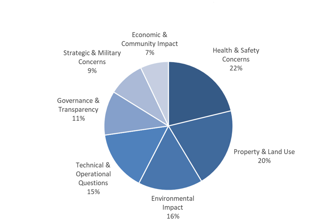
Caption
| Category | Distribution of Questions |
|---|---|
| Health & Safety Concerns | 22% |
| Property & Land Use | 20% |
| Environmental Impact | 16% |
| Technical & Operational Questions | 15% |
| Governance & Transparency | 11% |
| Strategic & Military Concerns | 9% |
| Economic & Community Impact | 7% |
Figure 7: Clearview Township 7pm Session - Questions per Category
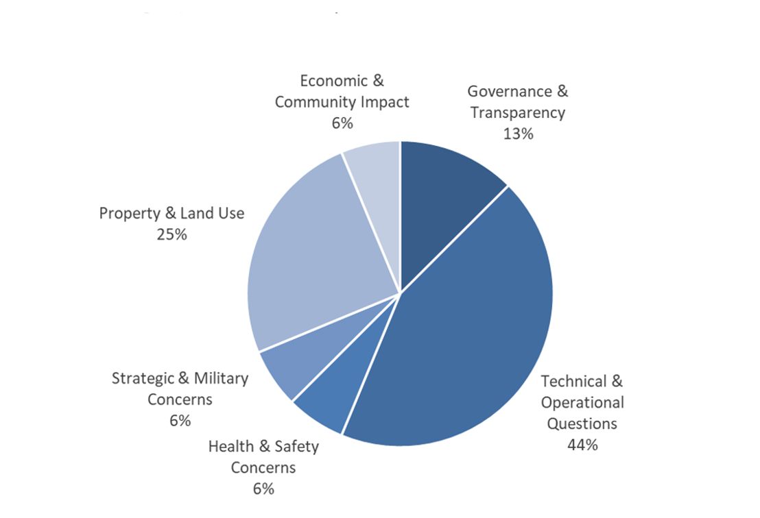
Caption
| Category | Distribution of Questions |
|---|---|
| Technical & Operational Questions | 44% |
| Property & Land Use | 25% |
| Governance & Transparency | 13% |
| Governance & Transparency | 13% |
| Health & Safety Concerns | 6% |
| Strategic & Military Concerns | 6% |
| Economic & Community Impact | 6% |
Annex D - Clearview Township Town Hall Presentation
Presentation from the 2:00 p.m. EDT and 7:00 p.m. EDT public engagement sessions held on September 10, 2025, in Creemore, ON
1. Context
1.1 - NORAD Modernization
- The North American Aerospace Defense Command (NORAD) is a binational military command between Canada and The United States (U.S.) responsible for aerospace warning, aerospace control, and maritime warning in defence of North America.
- There is a pressing need to modernize Canada’s NORAD capabilities in the context of the rapidly evolving global security environment.
- In June 2022, the Minister of National Defence announced Canada’s plan to enhance our contribution to NORAD with a total funding of $38.6 billion over twenty years.
- NORAD modernization is an important step in addressing Canada’s renewed requirements to strengthen the all-domain defence of Canada and North America.
1.2 - Why does Canada need an OTHR system?
- The existing North Warning System (NWS) was established in the 1980s and has not kept pace with new and emerging threats such as hypersonic weapons and advanced cruise missiles.
- As part of Canada’s NORAD modernization plan, DND is investing in a new Northern Approaches Surveillance System (NASS) to significantly expand NORAD and the CAF’s situational awareness of objects approaching and entering Canadian airspace from the North. NASS will include an Arctic Over-the-Horizon Radar (A-OTHR) system that will provide early warning radar coverage and threat tracking.
- The A-OTHR capability will be located in Southern Ontario and will extend NORAD and the Canadian Armed Forces’ (CAF) situational awareness into the Canadian North and the North Atlantic.
1.3 - Why does the A-OTHR need to be located in Southern Ontario?
- Over-the-Horizon Radar has the ability to conduct surveillance at far greater ranges than regular radar technology as it bounces radar beams off the ionosphere to see around the curvature of the Earth (see figure).
- The A-OTHR system needs to be in Southern Ontario to meet NORAD surveillance requirements.
![]()
Caption
Illustration of the process through which the Arctic Over-the-Horizon Radar (A-OTHR) reflects radio waves to observe targets up to 3000 km away. The transmit beam travels from Earth, reflects off the ionosphere, and reaches a target area within the 'Illumination region.' The receive beam returns from the target via the ionosphere. The ionosphere is a curved layer above Earth.
1.4 - Staged implementation approach
- The Department of National Defence (DND) is taking a staged approach to advance the A-OTHR program.
- The full A-OTHR capability will consist of four antenna farms (two transmit and two receive sites) and some supporting infrastructure.
- Stage 1 will install a full-sized permanent transmitter in Kawartha Lakes, Ontario, and a preliminary receiver in Clearview Township, Ontario, that will deliver initial, limited radar capabilities earlier than the full capability of the four sites.
- Radar coverage will expand across future stages based on Stage 1 performance and in response to Canada’s defence needs.
![]()
Caption
A-OTHR Stage 1
- Permanent transmit site (Tx1) in Kawartha Lakes, Ontario.
- Preliminary receive site (Rx0.5) in Clearview Township, Ontario.
![]()
Caption
A-OTHR End-Stage
- Permanent transmit site (Tx1) in Kawartha Lakes, Ontario.
- Second permanent transmit site (Tx2), location to be determined (TBD).
- Two permanent receive sites (Rx1 and Rx2), location TBD.
2. Siting
2.1 - Siting analysis
- In July 2023, prior to acquiring the Kawartha Lakes and Clearview Township sites, Public Services and Procurement Canada posted a notice on CanadaBuys and in community newspapers to inform property owners of DND’s interest to buy land in southern Ontario. Property owners had until August 31, 2023, to confirm their interest with PSPC.
- In addition, DND reached out to private landowners, Indigenous communities, other federal government departments, and the Province of Ontario to assess A-OTHR siting opportunities.
- The siting options that arose out of these discussions were deemed to be unsuitable for the program and DND proceeded with the purchase of privately owned land parcels listed on the open market for use as a transmit site (0 Thistle Trail, Kawartha Lakes, Ontario) and a preliminary receive site (2225 Sideroad 15 & 16, Clearview Township, Ontario).
2.2 - Clearview Township, Ontario, receive site
![]()
Caption
An aerial view outlining the site located at 2225 15th and 16th Sideroad, in Clearview Township, Ontario. The site runs adjacent to a road running east-west on the north side called Sunnidale Concession 7 and Sunnidale Concession 6 on the south side. South Sunnidale Sideroad 15 & 16 runs north-south adjacent to the site. There are agricultural land and wetlands surrounding the site.
Site information
- 288-hectares of agricultural land with some farm structures on the west side of the site.
- At the time of acquisition, the lands were actively used for growing and harvesting crops.
- The property consists of some wooded areas on the east side and is bisected by a creek.
- The site overlaps with Minesing Wetlands and provincial Areas of Natural and Scientific Interest (ANSI).
- The site falls within the regulated area of the Nottawasaga Valley Conservation Authority.
- Surrounding land consist predominately of agricultural lands with limited recreational and commercial uses.
2.3 - Where will the other A-OTHR sites be located?
- DND continues to assess options for the remaining permanent transmit site and two permanent receive sites.
- The remaining sites will be parcels of land ranging in size from 100 hectares to 1,200 hectares and will be located south of the 46th parallel north. As a frame of reference, this latitude roughly aligns with the Trans-Canada Highway within the provincial border of Ontario.
2.4 - Survey of landowner interest in selling their properties
- In July 2025, DND initiated a survey to gauge interest from landowners in Clearview Township regarding the potential sale of their lands to DND.
- Survey area spans over 2,000 hectares east and west of County Road 10.
- This data will help inform siting analysis in terms of timelines, costs, and other considerations raised by landowners during the survey process.
3. Implementation
3.1 - What will the A-OTHR look like?
- Land preparation will be required for each location. Required site works will include flattening of the land and removal of any obstructions that would impede the radar’s signal, including clearing of forested areas or filling of wetlands.
- The transmit sites will have a radiation hazard zone entirely contained within the site and be fenced to prevent access.
- While specific infrastructure needs are being finalized, the A-OTHR system will require supporting infrastructure at each site:
- Operations building
- Physical security features (e.g. fencing, patrol roads, gatehouse)
- Vehicle maintenance and storage facility
- Access road and parking
- Utilities (power, water, wastewater, stormwater, communications)
3.2 - Images of an OTHR (Australian example, for illustrative purposes)
Receive site (6m tall)
![]()
Caption
Two parallel rows of metallic posts anchored in the ground.
Transmit site (up to 45m tall)
![]()
Caption
An antenna array featuring multiple rows of metallic poles of varying height anchored in the ground, tethered by wires.
Note: the Canadian A-OTHR capability will be modified to meet Canada's environment and operational needs (e.g. different number of antennas, etc.)
3.3 - Site studies
- Ongoing:
- An assessment of watercourse and wetlands within or in proximity to the site that may be impacted by the program, including aspects such as stormwater management and flooding/erosion prevention measures.
- A Flora and Fauna assessment to determine a baseline that includes migratory birds, at risk wildlife (legislated both federally and provincially), and identification of habitat types in the site and surroundings.
- Stage 1 Archeological Overview Assessment of the area’s potential to contain valuable artifacts, structures, and evidence of Indigenous utilization.
- Stage 2, 3 and 4 (as needed) Archeological Overview Assessment including test pits, site excavation, and evaluation and conservation of archeological resources.
- Next steps:
- Environmental Effects Determination (under the Impact Assessment Act) to identify potential adverse environmental impacts and associated mitigation measures (e.g. restoration, offsetting or compensation for loss of vegetation, post-construction monitoring program, etc).
- Application for Environment and Climate Change Canada and Department of Fisheries and Oceans permits prior to any work affecting species at risk, as required.
3.4 - Are there any health and safety concerns?
- The areas surrounding the sites will comply with the national safety standards established by Health Canada regarding human exposure to radiofrequency electromagnetic fields.
- Fencing will be installed around the sites to ensure the public is not exposed to potential hazards.
- For the transmit sites, at ground level, beyond the perimeter fence, there are no known adverse human health effects associated with this type of technology.
- There are no known adverse human health effects associated with the receive sites.
3.5 - Stage 1 milestone schedule
![]()
Caption
An arrow-shaped flow chart showing a sequence of program activities, beginning with tree cutting in the winter of 2025/2026, followed by site clearing and leveling from 2026 to 2028, then equipment installation in 2029 and, finally, Over-the-Horizon Radar capability in 2029.
3.6 - Next steps
- The Department of National Defence will continue to provide updates as the program evolves.
- Public consultation remains open until September 15, 2025. A report summarizing public feedback will be published on the A-OTHR consultation webpage.
- Environmental Effects Determination will be published once finalized.
- Ongoing siting analysis for two permanent receive sites and a permanent transmit site.
Annex E – Clearview Town Hall Q&A Summary 2pm EST 10 September 2025
Introduction
Below is a structured summary of the questions and answers, grouped by theme, from the Clearview Township (receive site Rx0.5) session held at 2:00 p.m. EST on September 10, 2025. Wording is lightly paraphrased for clarity while preserving substance and reducing duplication.
1. Human Health & EMF Exposure
Q.1 What human and agricultural studies have you done? Are there impacts on animals and people?
A.1 The receive site only picks up very faint signals; the main challenge is detecting weak returns amid background noise. The technology and emissions are well studied; emissions of this sort are around us (e.g., LEDs, electronics).
Q.2 What are the actual levels at the receive site (numbers)?
A.2 Specific sensitivity/levels weren’t provided at the mic; DND said some numbers can’t be shared and would be better handled in a written Q&A.
Q.3 Canada’s standards (Safety Code 6) are weak/outdated. What waveform/magnitude will be used, and does the site make us a target?
A.3 Non ionizing EMR; FM-CW waveform; 3–30 MHz operating range. Receive signals arrive much fainter. On targeting: the system is for early warning; there will be perimeter/physical security and distance from community infrastructure.
Q.4 Will you do human health impact studies, and will federal standards be updated?
A.4 DND relies on Health Canada Safety Code 6 (last updated 2015) and its science review method. They set thresholds and safety margins. No separate “human health study” was committed beyond compliance with SC6.
Q.5 What is the geographic area of exposure from the receive site and μW/m² levels (e.g., at 10 km)?
A.5 DND did not give a number; said they’ll follow up. Emphasized efforts to keep the receive site area very low emission by controlling nearby RF noise sources.
Q.6 Will emissions be continuous (24/7)?
A.6 Operations will scale up; it could reach 24/7 when fully operational.
2. Environmental (Wetlands, Species, EA Process)
Q.1 Minesing Wetlands are globally significant; amphibian studies show sensitivity to RF (setbacks). Will you consult Nature Conservancy and allow a full EA and longer public comment? Is 1 kW emission true?
A.1 DND is working with ECCC, DFO, NVCA, and has engaged Nature Conservancy of Canada. They will post Environmental Effects Determinations (EEDs) to the Impact Assessment Registry with a comment period (acknowledged earlier short windows and said they’ll keep comments open longer for Clearview). No explicit confirmation of a “1 kW” figure at the mic.
Q.2 Will we be able to review and comment on the studies?
A.2 Yes – via the Canadian Impact Assessment Registry process.
Q.3 Are you proceeding before environmental approvals?
A.3 No. DND acknowledged they must complete studies and obtain permits/approvals (e.g., species at risk) before construction.
3. Technical Operation (Frequencies, Waveform, Range, Antennas)
Q.1 What exactly are the frequencies, waveform, and power?
A.1 3–30 MHz (HF); FM-CW waveform; transmit site uses kilowatt level power; the receive site is passive with very faint return signals.
Q.2 How far can it see, and what happens after detection?
A.2 Up to ~3,000 km from the transmit site. Tracks go to 22 Wing North Bay (CADS); 1 CAD/RCAF decide follow on actions (e.g., F 35, AEW).
Q.3 Antenna heights? Lights on antennas?
A.3 Receive antennas ~6 m; transmit antennas ~45–60 m. Lights on 6 m receive antennas not required; perimeter lighting will be designed to minimize light pollution while meeting security.
Q.4 Can the beam hit people “downstream”?
A.4 Beam is steered to the ionosphere and constrained so that emissions outside the fenced area remain within Safety Code 6.
4. Siting & “Why Southern Ontario?”
Q.1 Why not put this farther north where fewer people live? Is the tech outdated?
A.1 Due to ionospheric geometry (height and look angles), the required latitude for reliable Arctic coverage is in southern Ontario. The capability is enduring and used by allies; it’s part of a layered defense alongside evolving tech.
Q.2 Why this area and not bases like Borden/Meaford?
A.2 DND says it first looked at existing DND lands, then other public lands; analyzed hundreds of parcels for size, flatness, spacing, and RF environment; Base Borden is heavily tasked and could not be reconfigured without unacceptable training impact.
5. Land Acquisition, Surveys, Expropriation & Property Values
Q.1 You sent survey letters to landowners; are you going to expropriate if we say no?
A.1 The letters were to gather willingness information and inform siting; no siting decision has been made for full receive sites. DND emphasized intent to pursue willing buyer–willing seller negotiations and did not commit to (or formally rule out) expropriation, saying they are not at that stage.
Q.2 Will property values drop? Who compensates neighbors?
A.2 DND repeatedly stated it is not in a position to assess market impacts. They acknowledged the concern and said they would take it back to leadership.
Q.3 Appraisal and compensation if land is acquired?
A.3 Appraisals follow Treasury Board and PSPC (Chief Appraiser) processes; DND said they would enter direct negotiations, considering property specifics (including potential relocation needs).
Q.4 If Stage 2 never gets sited, is Stage 1 standalone?
A.4 Stage 1 (Tx1 + Rx0.5) proceeds on lands already acquired and provides capability beyond today, while siting for full Rx1/Rx2 continues.
6. Agriculture, Quiet Zones & Compatibility
Q.1 Will farming continue around the site? What’s a “quiet zone”?
A.1 Everyday agricultural activities (tractors, barns, hunting) can continue. Wind turbines are incompatible (RF noise). Solar projects would be case by case. DND invited specifics to analyze distances/effects.
Q.2 Will setbacks or new restrictions apply to surrounding properties?
A.2 No general ban on normal farming. For RF noisy installations near the receive site, restrictions may apply to protect system performance; exact distances are case specific and will be analyzed with residents.
7. Security & Target Risk
Q.1 Does the site make our community a target in wartime?
A.1 It’s a strategic asset designed for deterrence/early warning. Sites will have physical security and stand off distance; DND will conduct a threat and risk assessment and coordinate with local authorities.
8. Aviation, No Fly & Airports
Q.1 Will there be a no fly zone or impacts on local airports (e.g., Edenvale)?
A.1 Over defense sites there are standard constraints (especially for hovering/loiter near Tx). For Rx, normal traffic volumes are not an issue per DND’s initial assessments. DND asked pilots/airfields to share details for case by case analysis.
9. Construction Logistics, Traffic & Lighting
Q.1 What about truck traffic, dust, and safety near homes/schools during earthworks?
A.1 DND acknowledged significant construction and said they’ll work with the municipality on haul routes, safety and mitigation. Specifics pending design and contractor engagement.
Q.2 Will there be bright perimeter lights?
A.2 DND will design lighting to meet security while minimizing light pollution (placement/shielding considered in design).
10. Monitoring, Compliance & Transparency
Q.1 How will emissions be monitored and reported to the public?
A.1 DND committed to provide written explanations of certification and ongoing monitoring, including audits/verification, and to publish Environmental Effects Determinations on the Impact Assessment Registry.
Q.2 Will the sessions be recorded?
A.2 The session itself was not recorded, but a summary and presentation links would go on the project website; formal environmental documents will be on the Registry.
11. Governance, Decision Authority & Costs
Q.1 Who approved Stage 1 before this meeting? Is local approval required?
A.1 Government of Canada approved and announced Stage 1 sites; no local approval is required for federal projects on federal lands. DND implements the project.
Q.2 Accountability if harms/losses occur?
A.2 The project was announced by the Prime Minister/Minister of National Defence; DND said they would have to take back questions about specific liability/accountability.
Q.3 What’s the cost and who’s building it?
A.3 Infrastructure: Advance Procurement Notice posted; RFP forthcoming—no awards yet. Capability: collaboration with Australia (JORN); industrial benefits for Canada.
12. Indigenous Consultation
Q.1 Which First Nations have you consulted and how is that engagement recorded?
A.1 DND initially contacted ~50+ rights holders in southern Ontario; for the announced sites they are engaging those with specific claims, involving them in archaeology and environmental work as requested.
13. Utilities & Power
Q.1 How will the transmit site be powered?
A.1 DND is working with Hydro One to bring a dedicated high voltage feeder to the site. Broader grid planning or third party access to that line is Hydro One’s purview.
14. Community Benefits
Q.1 What do locals gain?
A.1 Construction activity (possible employment of local firms, services), long term maintenance/ISS presence (some local jobs due to response times), and federal payments in lieu of taxes to the municipality. DND acknowledged calls for more benefits and will take that back.
15. “Other” Technical/Clarifications
Q.1 Is this chemtrails/geoengineering or tied to NEXRAD/CERN/HAARP?
A.1 No; the system is an operational radar for early warning. It is not used for weather modification, earthquakes, etc. It is standalone (not NEXRAD). HAARP is a separate research facility; A-OTHR is not linked to CERN.
Q.1 Could satellites replace this?
A.1 Space systems are being explored but don’t match A-OTHR’s coverage and target set; layered approach envisaged.
16. Timeline & Schedule
Q.1 How quickly will this get built?
A.1 Studies are ongoing; construction targeted to start late 2026, continuing into 2028; equipment installation in 2029; aim for end 2029 Stage 1 operations (subject to environmental/permit approvals).
Annex F – Clearview Town Hall Q&A Summary 7pm EST 10 September 2025
Introduction
Below is a structured summary of the questions and answers, grouped by theme, from the Clearview Township (receive site Rx0.5) session held at 7:00 p.m. EST on September 10, 2025. Wording is lightly paraphrased for clarity while preserving substance and reducing duplication.
1. Human Health & EMF Exposure
Q.1 Studies show EMF can cause cancer, neurological issues, and other health effects. What are the actual radiation levels, and how wide is the exposure zone?
A.1 DND reiterated that the system uses non-ionizing HF signals and will comply with Health Canada Safety Code 6. They did not provide exact μW/m² figures at the meeting but committed to follow up with written details. They emphasized that the receive site is very low power and the transmit site will have a fenced hazard zone fully contained on-site.
Q.2 Will this add to existing RF exposure from devices like cell phones?
A.2 DND acknowledged public concern but stated that emissions outside the fenced zone will remain within Safety Code 6 limits. They noted that common household devices often emit more localized RF than what will be experienced outside the transmit site.
Q.3 Will there be continuous emissions?
A.3 The system may eventually operate 24/7, but initial operations will scale up gradually.
2. Environmental & Wildlife
Q.1 Will wetlands and species at risk be protected?
A.1 DND confirmed ongoing environmental studies and consultations with ECCC, DFO, and local conservation authorities. They will post Environmental Effects Determinations (EEDs) on the Impact Assessment Registry for public comment before construction.
Q.2 What about bird safety and wildlife impacts?
A.2 Based on allied experience, wildlife tends to avoid active transmit arrays. No evidence of mass bird mortality was reported from similar systems. At receive sites, antennas are passive and low-risk.
3. Technical Operation & Capability
Q.1 Why can’t satellites replace this system?
A.1 Space-based systems are being explored but cannot yet match AOTHR’s coverage, persistence, and ability to track certain targets. A layered defense approach is planned.
Q.2 Is this linked to HAARP, CERN, or weather modification?
A.2 No. AOTHR is an operational radar for early warning, not for geoengineering or ionospheric manipulation.
Q.3 Is this part of NATO’s 2% GDP commitment?
A.3 Yes, but the project predates recent announcements. It is part of NORAD modernization and Canada’s long-term defense commitments.
4. Siting & Strategic Rationale
Q.1 Why southern Ontario and not farther north?
A.1 Due to ionospheric geometry, the required latitude for Arctic coverage is in southern Ontario. Other locations would not provide the necessary coverage.
5. Land Use, Property & Community Impact
Q.1 Will property values drop?
A.1 DND said they cannot assess property value impacts but acknowledged the concern and will take it back to leadership.
Q.2 Will there be restrictions on nearby land use?
A.2 Everyday farming can continue. Restrictions may apply to wind turbines and other RF-noisy installations near the receive site.
Q.3 What benefits will the community see?
A.3 Potential construction jobs, local service demand, and long-term maintenance roles. DND also pays payments in lieu of taxes to the municipality.
6. Aviation & Airspace
Q.1 Will there be no-fly zones or restrictions for local airports and seaplanes?
A.1 Standard restrictions apply over defense sites, especially for hovering near transmit sites. Normal overflight is generally not an issue. DND will consult with pilots and local airports.
7. Security & Target Risk
Q.1 Does this make the area a military target?
A.1 DND acknowledged the site is a strategic asset but emphasized its purpose is deterrence and early warning. Physical security measures will be implemented.
8. Governance & Accountability
Q.1 Who approved this project?
A.1 The Government of Canada announced Stage 1; DND is implementing. No municipal approval is required for federal projects.
Q.2 Who is accountable if harm occurs?
A.2 DND said they would take that question back to leadership.
9. Construction & Logistics
Q.1 How will construction traffic and noise be managed?
A.1 DND will coordinate with municipalities on haul routes and mitigation measures. Details will come during design and contracting.
10. Timeline
Q.1 When will this be operational?
A.1 Studies continue through 2025; construction is planned for late 2026 until 2028; equipment installation in 2029; Stage 1 operational by end of 2029.