
The Georgia Basin-Puget Sound Airshed Characterization Report 2014: chapter 10
10. Regional Air Quality Modelling
Robert Kotchenruther (Environmental Protection Agency Region 10) and Bill Taylor (Environment Canada)
Previous chapters have described air quality issues and trends, including air contaminant sources, laying the foundation for discussing approaches to air quality management. The actions of regulatory agencies are often guided by computer model simulations, which help to develop a better understanding of the effects of reducing emissions on ambient air quality. This chapter describes the tools and models used to evaluate the air quality outcomes of proposed changes to contaminant emissions and outlines some of the major air quality modelling efforts that have been applied to the Georgia Basin/Puget Sound airshed in recent years. These studies address airshed management issues relevant to the area, such as the effect of controlling specific source sectors, implementing a planned suite of air quality management measures, generating plausible projections of future air quality and exploring the sensitivity of ozone and particulate matter to changes in precursor emissions.
10.1 Methodology for Evaluating Air Quality Management Plans and Proposed Emission Controls
Potential measures to improve air quality can be assessed by applying the essential tools of air quality science: monitoring, emissions inventories and computer models. The methodology used to predict the impacts of air management scenarios typically involves the following steps: the preparation of emission inventories including forecasting or backcasting to target years; selection or generation of appropriate meteorological inputs; air quality modelling; model performance evaluations; uncertainty evaluation or sensitivity assessment; and the estimation of health, economic, and environmental impacts, based on air quality model outputs.
The goal of this methodology is to link pollutant emission controls to ambient concentrations, and ultimately to societal and environmental impacts. Pollutant emissions are estimated and forecasted using methods described in Chapter 5, “Emissions”. The resulting changes in ambient concentrations are then derived through the use of air quality modelling systems, which simulate atmospheric fate and transport of pollutants as driven by emissions and meteorological inputs. Air quality models are primarily applied to assess the relative impacts of emission scenarios or to determine an airshed’s sensitivity to human-influenced atmospheric properties.
The model results provide concentration and deposition values that in turn are used to estimate pollutant exposure to important receptors such as human populations, infrastructure and the receiving environment. Damage to these receptors can be assessed and translated into indicators of human health, economic effects and ecological or wildlife impacts - topics which will be covered in subsequent chapters.
The complexity of this process yields compounding uncertainties, which are amplified when the policy scenario is forecast to the future. This chapter describes the results of studies within their scope and limits of accuracy.
10.2 Applying Chemical Transport Models (Adapted from Gong et al., 2011; Makar et al., 2010)
Chemical Transport Models (CTMs) are at the heart of air quality modelling conducted over a regional scale (such as the Georgia Basin/ Puget Sound airshed). CTMs are computer models that simulate the various chemical and physical processes involved in linking precursor emissions to ambient concentrations and deposition of pollutants. These models are usually part of a larger modelling system which also includes an emission processing component and a meteorological model.
The CTMs simulate the 3-dimensional atmosphere by solving differential equations at regularly spaced grid-points. The time evolution of changes in mass of gas and particle species is computed at each grid point at a defined time step. The spatial resolution of these models is often variable allowing for finer resolution over smaller sub-regions, while retaining a coarser resolution in a wider domain. Processes that cannot be resolved at the spatial scale of the model grid are parameterized into the model.
Meteorological inputs, such as three dimensional temperature and wind fields required for CTMs are generated by meteorological models, also known as numerical weather prediction models. For past studies, the CMAQ model, a CTM developed by the U.S. Environmental Protection Agency, has been driven by Environment Canada’s Global Environmental Multiscale (GEM) model, the Mesoscale Compressible Community (MC2) meteorological model, as well as by the fifth generation Mesoscale Model (MM5) from Penn State/NCAR. More recently, MM5 has been replaced by the Weather Research and Forecast model (WRF). Emissions data, a vital input into CTMs, are processed using an emission processing system such as the Sparse Matrix Operator Kernel Emissions system (SMOKE). Typically SMOKE uses annual totals of point, area and mobile sources of precursor emissions from emissions inventories and allocates them to a spatial grid at a time step which is compatible with the requirements of the CTM, typically hourly. SMOKE can also incorporate emissions data over a range of temporal resolutions if available.
From these emissions and meteorological inputs, the model simulates the relevant physical and chemical processes through time, and generates spatial output files of pollutant concentrations over a defined geographic area. Typically, model output is produced in the form of computer animations of spatial fields which display changes in the distribution of pollutant concentrations over the course of an episode of poor air quality. Such animations can be highly instructive in showing which areas are most affected by proposed emission controls.
CTMs commonly applied in United States and Canada to regional air quality modelling include CMAQ, CAMx, AURAMS and CHRONOS. These acronyms refer to respectively: Community Multi-scale Air Quality model (CMAQ, Byun and Schere, 2006; Carlton et al., 2010), Comprehensive Air quality Model with extensions (CAMx), A Unified Regional Air-quality Modelling System (AURAMS), and Canadian Hemispheric and Regional Ozone and NOx System (CHRONOS). As previously mentioned, CMAQ was developed by the U.S. Environmental Protection Agency (EPA) and CAMx was developed by ENVIRON Inc. AURAMS and CHRONOS are Canadian models developed by Environment Canada. In the U.S., the National Oceanic and Atmospheric Administration (NOAA)’s operational air quality forecast system employs the WRF meteorological model to drive CMAQ in an off-line approach. In the Northwest, the Air-quality forecasting for the Pacific Northwest (AIRPACT) daily air quality forecast system employs WRF output produced by the University of Washington (http://www.atmos.washington.edu/mm5rt/) to drive CMAQ operated by Washington State University (http://lar.wsu.edu/airpact/). Various research groups in the U.S. and elsewhere employ WRF-CHEM developed as an online or coupled meteorological/chemical transport system, and EPA has a WRF-CMAQ coupled system under development. These coupled systems are designed to account for the feedback between aerosol effects on solar radiation and impacts on boundary layer energy transfer. In Canada, the current operational air quality forecast model is GEM-MACH (Global Environmental Multi-scale - Modelling Air quality and CHemistry), also an on-line coupled model. Detailed descriptions of these models are given by Gong et al. (2011) and Makar et al. (2010).
10.3 Case Studies for Georgia Basin/Puget Sound Airshed
This section reviews some of the major air quality modelling studies undertaken in recent years in the Georgia Basin/Puget Sound region Five such studies are highlighted. The first examines the impact of proposed emissions reductions associated with the implementation of Metro Vancouver’s 2005 Air Quality Management Plan. The second study focuses on the effect of proposed mitigation strategies on ozone concentrations in Puget Sound by 2015. The third study investigates agricultural ammonia in the Lower Fraser Valley and the effect of a large hypothetical reduction in ammonia emissions. The fourth study focuses on modelling of the impacts of implementation of the International Maritime Organization marine Emissions Control Area designation to limit emissions from marine vessels operating in coastal waters. Finally, the fifth study examines improvements to air quality, leading to potential health benefits associated with the implementation of the 2008 BC Climate Action Plan and the 2008 BC Air Action Plan.
In three of these studies, the modelling was performed on behalf of Environment Canada by RWDI Inc. The modelling system consists of CMAQ, versions 4.2 to 4.6, with emission inventory data compiled and processed by SMOKE versions 2.1 to 2.3. The meteorological model initially used was MC2; however, this was later replaced by GEM-LAM, Environment Canada’s current weather forecasting model. The modelling was performed over the Pacific Northwest domain at a horizontal resolution of 4 km over the Georgia Basin sub-domain nested within a 12 km or 36 km outer grid. Emissions for the Lower Fraser Valley, including Whatcom County, were obtained from the 2000 Canadian Air Contaminants (CAC) emissions inventory and the 2000 GVRD (now Metro Vancouver) emissions inventory. For the rest of the U.S. portion of the basin, the U.S. 1999 or 2001 National Emission Inventory (NEI) was used.
These case studies typically involve policy scenarios or emission reduction scenarios whereby ambient air quality is simulated relative to the base case after the introduction of specified emission controls. Except for the Puget Sound ozone modelling work, the base cases include a 2001 summer case (August 9 to 31) as well as a 2002 winter case (December 1 to 13). The summer 2001 base case occurred during Pacific 2001, an intensive air quality field study that spanned a variety of summer weather conditions including several days of hot stagnant air accompanied by episodes of poor air quality. The winter case also covers a period during which stagnant conditions conducive to elevated PM2.5 were observed. Ozone results were not presented for the winter case due to the mitigating effects of low temperatures and solar radiation on photochemical production. The base cases are identical in all three of the RWDI studies. Emissions inventories, which include both biogenic and anthropogenic emissions, were projected to 2001-02 to establish emissions for the base case. As necessary, emissions for the base case are projected into the future to form a Business-As-Usual (BAU) case.
10.3.1 Impacts of Metro Vancouver's Air Quality Management Plan on Ambient Levels of Ozone and PM2.5
In 2005, Metro Vancouver adopted its second Air Quality Management Plan (AQMP), which it describes as “a long term strategy for ensuring clean air for future generations” (Metro Vancouver, 2007a). Although Greater Vancouver currently experiences good regional air quality relative to most other North American cities, emissions of some air contaminants such as particulate matter and greenhouse gases are forecast to increase, as a result of predicted growth in population, trade and transportation. To address this projected upward trend, Metro Vancouver has identified a number of actions aimed at reducing PM and ozone precursor emissions from major sources in the region. These actions target a number of different sectors including marine, transportation, industrial, residential, and agricultural.
Ozone and PM2.5 Modelling and Emissions Scenarios
Air quality modelling in this study was performed by RWDI using the MC2/SMOKE/CMAQ modelling system described earlier (RWDI, 2006). Each of the policy scenarios was evaluated with reference to the 2015 Business-As-Usual (BAU) case. British Columbia emissions for the base case, the 2015 BAU and the various policy scenarios are detailed in Table 10.1. (RWDI, 2006)
| AQMP Scenario | CO | NOx | VOC | NH3 | SO2 | PM10 | PM2.5 |
|---|---|---|---|---|---|---|---|
| Base Case |
1824
|
444
|
304
|
72
|
132
|
211
|
82
|
| 2015 BAU |
1872
|
380
|
277
|
75
|
141
|
262
|
89
|
| AQMP Actions |
1754
|
363
|
262
|
73
|
130
|
259
|
87
|
| Marine |
1871
|
371
|
277
|
75
|
128
|
260
|
87
|
| Non-road |
1872
|
375
|
277
|
75
|
141
|
262
|
89
|
| Point Sources |
1872
|
374
|
277
|
75
|
139
|
262
|
89
|
| AQMP Plus Actions |
1742
|
349
|
260
|
69
|
125
|
257
|
86
|
Description of Table 10.1
Table 10.1 gives emissions for British Columbia under each Metro Vancouver AQMP scenario in the 4 km domain (tonnes/day).
The first row of the table contains the headers “AQMP Scenario”, “CO”, “NOx”, “VOC”, “NH3”, “SO2”, ”PM10”, and “PM2.5”. The first column shows the various policy scenarios. These are as follows:
- Base Case
- 2015 BAU
- AQMP Actions
- Marine
- Non-road
- Point Sources
- AQMP Plus Actions
The second through eighth columns give the emissions in tonnes/day for each of the pollutants given in the column headers.
Base Case. Emissions for the August 2001 and December 2002 base cases were modified from the 2000 Canadian CAC Emissions Inventory and the 2002 U.S. National Emissions Inventory.
2015 BAU. A business-as-usual (BAU) case was developed for the year 2015 based on emission forecasts for that year resulting from population and economic growth projections and existing regulations, but excluding any new regulations. The BAU scenario is a projection of the summer and winter base cases of 2001 and 2002 described earlier.
The 2015 BAU scenario depicts an increase in summertime ozone, compared to August 2001, in the Metro Vancouver area, Whatcom County and parts of Vancouver Island. A decrease in ozone is seen over the Strait of Georgia, Juan de Fuca Strait and Puget Sound. The increase in ozone around Metro Vancouver is due to weaker titration effects associated with a reduction in NOx by 2015. Conversely, NOx emissions in Puget Sound and the Seattle area are forecast to increase in 2015, resulting in a decrease in ozone relative to 2001 (RWDI, 2006).
Summertime PM2.5 is forecast to increase throughout the domain in 2015 due to increases in primary PM2.5, NOx, and SO2, except around Metro Vancouver which shows a decrease in 2015 due to a projected reduction in NOx in both summer and winter. Increases in wintertime precursors in the rest of the domain result in an overall increase in PM2.5 levels throughout the region (RWDI, 2006).
AQMP Actions. The first policy scenario assumes implementation of AQMP actions applied to the Metro Vancouver portion of the modelling domain in addition to emission changes defined in the 2015 BAU case. Included in these actions are heavy duty vehicle emissions standards, fuel efficiency standards, improved agricultural practices, more efficient space heating and regulations of wood burning appliances. This scenario results in a 4.5 per cent reduction in NOx emissions relative to the 2015 BAU.
Small increases (~1%) in 8-hour average ground level ozone from the Lower Fraser Valley (LFV) to Seattle and the southern tip of Vancouver Island are projected to occur as a result of weaker titration near the main NOx sources. Downwind of these areas, ozone concentrations show a slight decrease. Mean hourly PM2.5 levels are reduced by roughly 2 to 6 per cent in the Lower Fraser Valley in both summer and winter as a result of lower primary PM2.5, VOC, NOx, and SO2 emissions (RWDI, 2006).
Marine. The next scenario evaluates the impact of reducing marine emissions by 2015 through the implementation of low sulphur fuel for ocean going vessels, increased use of shore power for ships in port, changes to BC Ferries cooling systems and re-powering and retrofitting harbour vessels.
Small increases in ozone in the marine seaways in the Strait of Georgia, Juan de Fuca Strait, and Puget Sound are associated with weaker titration resulting from NOx reductions in these areas. Downwind of these waterways, small decreases in ozone are seen. PM2.5 levels decrease in response to reductions in marine emissions of primary PM2.5, NOx, and SO2(RWDI, 2006).
Non-road. This scenario includes emission reductions by 2015 from non-road engines through re-powering and diesel oxidation catalysts. NOx reductions from non-road sources relative to 2015 BAU result in slight increases in ozone concentrations from weaker titration near emission sources from the WISE to Seattle and the southern tip of Vancouver Island. Modest reductions in NOx and primary PM2.5 from non-road sources result in minor decreases in ambient PM2.5 (RWDI, 2006).
Point Sources. The next scenario considers the impact of reducing emissions from large point sources in the Metro Vancouver region by 2015 including cement plants and refineries. Specifically, NOx was reduced at the two cement plants by 2100 tonnes, and SOx and PM2.5 from refineries by 850 tonnes and 50 tonnes, respectively. These reductions amounted to decreases of approximately 2.0, 1.0 and 0.1 per cent respectively of all emissions within the modelling domain.
Reduction in emissions from point sources relative to 2015 BAU is expected to have a very minor effect on ozone and PM2.5 concentrations in the Metro Vancouver area, as there are relatively few thermal power plants in the region (RWDI, 2006).
AQMP plus. The final scenario includes the sum of all of the policy actions identified in the previous scenarios applied to the Metro Vancouver area as well as the Fraser Valley Regional District. The reductions amounted to decreases in NOx emissions (8%), VOC emissions (6%), SO2 emissions (11%) and PM2.5 emissions (2%) over the modelling domain (RWDI, 2006).
The combination of mitigation strategies represented in this scenario results in a moderate increase in ground-level ozone from the marine seaways in the Strait of Georgia, Juan de Fuca Strait, and from Puget Sound to the Metro Vancouver area. Reduced NOx emissions in those areas weaken ozone titration, leading to higher ozone concentrations. Small localized areas of ozone decreases occur just downwind (RWDI, 2006).
PM2.5 levels show decreases throughout the study area in both summer and winter as a result of reductions in primary PM2.5, VOC, NOx, and SO2 (RWDI, 2006).
10.3.2 Impacts of Emissions Controls on Ambient Levels of Ozone in the Puget Sound
In a separate study, Lamb et al. (2006) modelled ozone concentrations over Puget Sound using the MM5-SMOKE-CMAQ modelling system. A base case for ozone was modelled for an episode which occurred during July 22-28, 1998. Emissions were forecast to 2015, with an additional scenario to assess potential ozone levels from projected future growth which assumed use of low volatility gasoline. A sensitivity analysis was also performed on the base case ozone levels to assess the impact of changes in precursor emissions, both in aggregate and from various sectors (Lamb et al., 2006). Given emissions reduction measures in NOx and VOCs planned for 2015 in Washington and Oregon, the results suggested that daily maximum 8-hour ozone levels in Puget Sound may improve during high ozone events and that the Puget Sound will be in attainment of the current 8-hour ozone NAAQS of 75 ppb in 2015. Both NOx and VOCs are expected to decrease even without considering the new marine vessel emissions control area (IMO, 2009), which would impart further NOx reductions. The sensitivity analysis suggested that the dense urban areas and the associated polluted airsheds west of the Cascades are both VOC-limited. In short, maximum 8-hour ozone was predicted to improve marginally during summer episodes by 2015 due to projected emissions reductions, of which the use of low volatility gasoline would play a minimal role.
10.3.3 Impacts of Agricultural Ammonia Reductions During the 2004 Poultry Cull in the Lower Fraser Valley
The Canadian Lower Fraser Valley (LFV) has the highest concentrations of ambient ammonia in Canada which contributes significantly to ambient PM2.5 in the area. The ammonium ion (NH4+), a product of the reaction of ammonia with atmospheric acids, contributes approximately 1/3 to the total PM2.5 mass in the LFV, reflecting the large ammonia availability. Emissions inventories estimate that 12,000 metric tonnes of ammonia were emitted in 2005 with 66 per cent being accounted for by agriculture (Metro Vancouver, 2007b).
Livestock production and the use of synthetic fertilizers are the primary agricultural sources of ammonia in the LFV. The role of ammonia in fine particle formation has been an issue of much interest in the WISE due to the extent of agricultural activity occurring within the confines of the valley geography. Ammonia emissions are highest in the central and eastern areas of the LFV, particularly in the vicinity of Abbotsford and Chilliwack, where poultry and dairy farm production is concentrated. The poultry industry emits the largest proportion of agricultural ammonia emissions (55%), followed by cattle (22%) and fertilizer application (10%) (Metro Vancouver, 2007b).
High ambient concentrations of ammonia are found in the central and eastern LFV, particularly around Abbotsford, where poultry rearing emissions are also high. Here, mean annual levels range between 10-20 µg/m3 and hourly maxima can exceed 200 µg/m3. Elevated ammonia concentrations are highly localized near agricultural sources in the WISE and drop off rapidly with increasing distance from sources. Concentrations tend to be highest in the summer and fall seasons and during the night. Particulate ammonium ion is spatially more dispersed throughout the airshed, with areas of elevated concentrations throughout the WISE and surrounding region (Vet et al., 2010).
Ammonia Measurements During the Poultry Cull
In mid-February 2004, the Canadian Food Inspection Agency announced an outbreak of avian influenza in Fraser Valley poultry. Culling operations and other measures were performed in an effort to control the spread of the virus. The poultry cull provided a unique opportunity to study the effects of a poultry farming shutdown on ammonia, fine particulate and visibility in the LFV.
Ambient ammonia data were compared for the June to August cull (2004) and post-cull (2005) periods, respectively, at three sites: Abbotsford, Chilliwack and Langley (Figure 10.1). The cull had its greatest effect at the Abbotsford site with mean daily ammonia concentrations during the summer of 2004 being approximately two thirds lower (11 µg/m3) than the following year’s levels (30 µg/m3), when full poultry production had resumed. In contrast, no differences were observed at the Langley and Chilliwack sites between the two years, revealing the localized nature of the ammonia reduction. Also, there was a lack of a discernible effect on particulate ammonium concentrations and limited effect on PM2.5 concentrations (9.5% decline) at Abbotsford. These results suggest that PM formation is limited by precursor species other than ammonia in this part of the WISE (Vet et al., 2010).
Table 10.1. Emissions for B.C. for each Metro Vancouver AQMP scenario in the 4 km domain (tonnes/day). (RWDI, 2006)
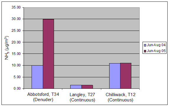
Note: Although continuous ammonia samplers were used at all three sites, calibration issues in 2004 affected the reliability of data at Abbotsford; therefore, data from a co-located denuder was used instead. Comparison of the denuder and the continuous sampler data for a period after the calibration issue (January to June 2005) showed good agreement (slope = 0.89; R2 = 0.96).
Description of Figure 10.1
Figure 10.1 is a bar chart showing ammonia concentration in µg/m3 for the summers of 2004 and 2005 in Abbotsford, Langley, and Chilliwack. There is a note that although continuous ammonia samplers were used at all three sites, calibration issues in 2004 affected the reliability of data at Abbotsford; therefore, data from a co-located denuder was used instead. Comparison of the denuder and the continuous sampler data for a period after the calibration issue (January to June 2005) showed good agreement (slope = 0.89; R2 = 0.96).
For Abbotsford (T34, denuder data) the June - August 2004 concentration was 10 µg/m3 and the June - August 2005 concentration was just below 30 µg/m3.
For Langley (T27, continuous data) the June - August 2004 concentration and the June - August 2005 concentration were both approximately 2 µg/m3.
For Chilliwack (T12, continuous data) the June - August 2004 concentration and the June - August 2005 concentration were both approximately 11 µg/m3.
Ammonia Emission Reduction Scenario
The MC2/SMOKE/CMAQ modelling system was used to provide insight into agricultural management practices for controlling ammonia in the WISE (RWDI, 2006). A number of emission reduction scenarios were evaluated, ranging from 20 to 80 per cent reductions in agricultural ammonia on the Canadian part of the valley. The effect of these reductions on ambient PM2.5concentration was evaluated for a 36 km2 area centered on south Abbotsford. Changes in PM2.5 concentrations were evaluated by comparing to the base case which assumes no ammonia emission reductions.
Based on the 60 per cent ammonia reduction scenario, chosen to resemble the reduction during the poultry cull period, the modelled average PM2.5was reduced by a modest 1.5 µg/m3 or 9 per cent compared to the base case. This is in good agreement with the measured decline in ambient PM2.5 of 9.5 per cent compared to summer 2005 levels at the Abbotsford site. The reduction in PMconcentrations, as indicated by the model, is highly localized to the Abbotsford area where poultry operations are more intensely concentrated. However, at certain times during the modelling period, reductions in ammonia emissions did lead to widespread PM2.5reductions, as sea-land breezes and mountain-valley flows transported the effects of the emission changes throughout the study area. On the whole, the modest average reduction in PM2.5 combined with the highly localized nature of the reduction confirms that particle formation in the WISE is not ammonia limited. In addition, the effects of reducing ammonia emissions on ozone concentrations were negligible. In summary, both measured and simulated ammonia emission reductions during the 2004 poultry cull point to a significant excess of ammonia in the eastern LFV. The low sensitivity of PM2.5 to ammonia reductions, coupled with the very localized effect, suggests that PM2.5 reduction strategies need to include multiple PMprecursors in addition to NH3.
10.3.4 Impact of the Implementation of the Marine Emission Control Area
Diesel powered ships engines are significant mobile source emitters of PM, SOx, and NOx. Most are not subject to emissions regulations and operate on fuel that has high sulphur content. As a result, they have a significant impact on air quality in coastal and nearby inland areas (U.S. EPA, 2010).
In March of 2010 the International Maritime Organization approved a Joint U.S., Canadian, and French application for an Emission Control Area (ECA) off the coast of North America. The initial application was submitted by the U.S. and Canada in March of 2009 with France joining in June 2009 on behalf of its territories of Saint-Pierre and Miquelon, which lie off the coast of Newfoundland (IMO, 2009). The implementation of the ECA came in effect in August 2012.
As a result of the IMO designation, large ships operating in a North American ECA are now subject to strict standards for SOx and NOx emissions leading to significant PM and ozone reductions. While operating in the ECA, as of 2012, ships are required to achieve SOx emissions equivalent to using fuel with a sulphur content less than 1% and by 2015 they will be required to further reduce sulphur content to 0.1% (1,000 ppm), a 96 per cent reduction relative to pre-ECA implementation. Ships built in 2016 or later will be required to meet a stringent NOxstandard in the ECA, representing an 80 per cent reduction from current standards. These new standards correspond to the most stringent emissions reductions described in the policy scenario SCN1. Emissions can be reduced through the use of lower sulphur fuels or the use of after treatment technologies (scrubbers, selective catalytic reduction). In the United States, Canada and other parts of the world, low-sulphur fuel, which meets the 0.1% fuel sulphur limit, is already available (IMO, 2009).
Designation of the ECA required the proponents to demonstrate to the IMO that marine vessels operating in the area contribute to ambient concentrations of air pollutants or have adverse environmental impacts (IMO, 2009). This was achieved through air quality modelling in various coastal regions of the U.S. and Canada. In the Pacific Northwest, regional scale CTM modelling was undertaken by RWDI (2009) on behalf of the Pacific & Yukon Region of Environment Canada to simulate the impacts of various emission control strategies applied to marine vessels. Lower resolution, continental scale modelling was also undertaken by applying AURAMS over Canada and CMAQ over the U.S.
AURAMS Modelling of Ozone and PM2.5
The Canadian AURAMS model was run on the national domain at 42 km resolution, and a portion of the model domain over southwestern BC was extracted as shown in Figure 10.2and Figure 10.3. Figure 10.2 shows the projected 8-hour summer ozone concentration reductions for the Georgia Basin in 2020 occurring as a result of ECA implementation. Average summer reductions of 1 to 5 per cent are expected through most of the region with over 5 per cent reductions expected along the Juan de Fuca Strait (IMO, 2009). An exception is the urban center of Vancouver, where a reduced level of titration by NO may cause an increase in ambient ozone.
Figure 10.2. Reduction in Average Daily Maximum 8-hour Ozone over the Georgia Basin in 2020 resulting from implementation of the ECA (Adapted from IMO, 2009)
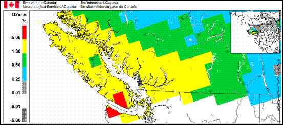
Note: Based on AURAMS model results at 42 km resolution.
Description of Figure 10.2
Figure 10.2 shows a line map of southwestern British Columbia colored by the reduction in average daily maximum 8-hour ozone in 2020 resulting from implementation of the ECA. The data is based on AURAMS model results at 42 km resolution and as a result each ‘pixel’ of the coloring is a 42 km cell. As described in the text average reductions of 1 to 5 percent are expected through most of the region west of the Coast Mountains and including Vancouver Island. Reductions of over 5 percent are expected along the Juan de Fuca Strait. In the urban center of Vancouver an increase of 0-5% is expected. In the interior of British Columbia reductions of 0.25 to 1 percent are expected.
The projected reduction in PM2.5 concentration in 2020 for the Georgia Basin resulting from the proposed ECA is shown in Figure 10.3. The improvements range from 5 to greater than 10 per cent reductions in mean annual ambient levels of PM2.5.
Figure 10.3. Projected Reduction in Levels of Mean Annual Ambient PM2.5 in the Georgia Basin for 2020 from implementation of the ECA Compared to Base Case (Adapted from IMO, 2009)
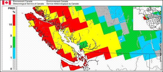
Note: Based on AURAMS model results at 42 km resolution.
Description of Figure 10.3
Figure 10.3 shows a line map of southwestern British Columbia colored by the percent reduction in mean annual ambient PM2.5 resulting from implementation of the ECA. The data is based on AURAMS model results at 42 km resolution and as a result each ‘pixel’ of the coloring is a 42 km cell. Reductions of over 10% are expected in northern Puget Sound and along the Strait of Juan de Fuca. Northern and western Vancouver Island, Johnstone Strait, Saturna Island, Pender Island, Galiano Island, and the area around Boundary Bay are also expected to see reductions of over 10%. Metro Vancouver and eastern Howe Sound are expected to see reductions of 2-5% while the remainder of the airshed is expected to see reductions of 5-10%. In the interior of British Columbia reductions of 0 to 5 percent are expected.
Continental scale modelling using CMAQ (12 km grid nested in a 36 km grid) over the U.S. showed comparable reductions in summertime (May to September) ozone and annual PM2.5 in all coastal regions for 2020. The Puget Sound area should see improvement of 0.25 to 1.0 per cent for summer season 8-hour maximum ozone and 5 to 15 per cent for annual average PM2.5. The benefits are expected to extend well inland into eastern Washington and Oregon (IMO, 2009).
Implementation of the North American ECA will also benefit ecological systems. Modelling results show that implementation of the ECA will result in significant reductions in sulphur and nitrogen deposition in both the U.S. and Canada. U.S. studies have shown sulphur deposition reductions will be between 4 and 25 per cent in the Pacific Northwest in 2020, while nitrogen deposition reductions along the Pacific coast are expected to be more modest (3 to 15 per cent) than those for sulphur but will be greater than 20 per cent in some cases. Canadian models have shown that improving ship emissions from current performance to ECA standards will result in reductions in total sulphur deposition that are estimated to be up to 60 per cent in the WISE for 2020 and up to 90 per cent on Vancouver Island. For total nitrogen deposition, reductions in south-western British Columbia will be up to 15 per cent (IMO, 2009).
The expected decreases in sulphur and nitrogen deposition will lead to reduced critical load exceedances for lakes and upland forest soil areas. In the Georgia Basin marine vessel emissions under a business as usual case would equal up to 100 per cent of the deposition excess amount in some areas (IMO, 2009). The excess amount is defined as the amount of deposition over the critical load. For example, if the critical load is 1000 kg/ha/yr and 1100 kg/ha/yr is deposited, then the excess amount is 100 kg/ha/yr. The change in excess is shown in Figure 10.4.
Figure 10.4. Percent Reduction in Excess Sulphur and Nitrogen in South-western British Columbia for the Proposed ECA Compared to Current Ship Emissions. (Adapted from IMO, 2009)
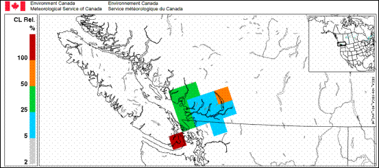
Note: The excess sulphur and nitrogen is defined as the amount of deposition over the critical load established for lakes and upland forest soils. Based on AURAMS model results at 42 km resolution.
Description of Figure 10.4
Figure 10.4 shows a line map of southwestern British Columbia colored by the percent reduction in excess sulphur and nitrogen resulting from implementation of the ECA. The excess sulphur and nitrogen is defined as the amount of deposition over the critical load established for lakes and upland forest soils. The data is based on AURAMS model results at 42 km resolution and as a result each ‘pixel’ of the coloring is a 42 km cell. The area around Victoria and the northeastern extremity of the Strait of Juan de Fuca is expected to see reductions in excess of 100%. The southern Strait of Georgia, metro Vancouver, Howe Sound and the southern Sunshine Coast are expected to see reductions of 25-50%. The lower Fraser Valley is expected to see reductions of 5-25% with the exception of northern Harrison Lake which is expected to see reductions of 50-100%.
Visibility is also expected to be positively impacted by implementation of the ECA. Without the ECA it is predicted that in 2020, almost 6 per cent of visibility degradation, in terms of deciviews, in Washington State’s North Cascades National Park would be from ship emissions. In addition to ecological and visibility benefits, the new ECA is expected to provide considerable health benefits from improvements in air quality. Reductions in both mortality and morbidity are expected in both the U.S. and Canada (IMO, 2009).
10.3.5 Benefits from the 2008 British Columbia Climate Action Plan (CAP) and the 2008 British Columbia Air Action Plan (AAP)
In 2009, the BC provincial government contracted ENVIRON to document the health benefits to British Columbians attributed to the 2008 Climate Action Plan (CAP) and the 2008 Air Action Plan (AAP). Although the Climate Action Plan targets efforts to reduce greenhouse gases, many of the measures contained in that plan will also bring about reductions in criteria air contaminants (ENVIRON, 2009).
Ozone and PM2.5 Modelling and Emission Scenarios
Air quality modelling was conducted using MM5/SMOKE/CMAQ at 36 km over the entire province. Emission inventory data were first segregated into the 19 source sectors targeted by the CAP and AAP control measures in order to more accurately represent impacts of these control programs on source emission levels. Each source sector inventory component was further allocated to Census Divisions through a grid-cell/Census Division allocation procedure to link health benefits to population (ENVIRON, 2009).
The Air Action Plan includes 28 actions related to transportation (e.g. anti-idling, school bus and transit bus retrofits), industry (e.g. eliminate wood residue burners) and communities (e.g. woodstove reductions). Further, many of the Climate Action Plan initiatives focus on energy efficiency and renewable energy that will have the additional benefit of reducing NOx and SO2emissions. Annual total emissions by sector for reference scenarios and policy scenarios were tabulated every three years from a 2005 base case to 2020 (ENVIRON, 2009).
Province-wide, the Air Action Plan is expected to reduce PM2.5significantly. The Climate Action Plan is projected to result in significant NOx and SO2 reductions. Both plans are projected to result in significant VOCreductions. Table 10.2 shows the projected combined benefits of these proposed reductions in emissions in three census divisions of the province as a result of implementing the Air Action Plan and the Climate Action Plan by the year 2020 relative to the 2020 Business-As-Usual (BAU) scenario.
| NO2 | SO2 | PM2.5 | O3 | |
|---|---|---|---|---|
| Metric | 24 hr Annual Avg. |
24 hr Annual Avg. |
24 hr Annual Avg. |
Daily 1 hr Max May-Sep Avg. |
| Fraser Valley |
-15.6%
|
-12.2%
|
-2.4%
|
-16.4%
|
| Greater Vancouver |
-41.8%
|
-24.8%
|
-3.7%
|
-29.3%
|
| Capital Region |
-36.1%
|
-13.3%
|
-3.2%
|
-13.5%
|
Description of Table 10.2
Table 10.2 gives the projected reductions in ambient concentration of four different pollutants as a result of the Air Action Plan and the Climate Action Plan for 2020 (versus the BAU case for 2020) in three census divisions of British Columbia.
The first row of the table contains a blank header in the first column, followed by the headers “NO2”, “SO2”, “PM2.5”, and “O3” in the second through fifth columns. The second row gives the metric for measuring reductions in each pollutant. For NO2, SO2, and PM2.5 this is 24 hr Annual Avg. For O3 it is Daily 1 hr Max, May-Sep Avg.
Rows three through five give the reductions in each pollutant (as a percentage) for each of the three census divisions considered. Row three gives information for the Fraser Valley, row four gives information for the Greater Vancouver, and row five gives information for the Capital Region.
The study concluded that the implementation of the AAP and the CAP would reduce premature mortality by 366 deaths per year and asthma cases by 30,000 per year, province-wide in 2020. Air quality improvements, and hence health benefits, tend to be concentrated in the most populous parts of the province, i.e. Greater Vancouver and the Capital (Victoria) Region. Together, these programs are expected to result in significant reductions to the burden on BC’s health care system due to air pollution (ENVIRON, 2009).
10.4 Chapter Summary
Regional air quality modelling systems are an essential tool for evaluating proposed management actions and emissions controls on ambient air quality. Scenario modelling studies reviewed in this chapter were performed using either CMAQ or AURAMS chemical transport models, in conjunction with MM5, MC2 or GEM-LAM meteorological models, with emission inventory data being processed by SMOKE. CMAQ modelling was performed over the Pacific Northwest domain at a spatial resolution of 36 km or 12 km, with detailed modelling on a sub-domain over the Georgia Basin/Puget Sound of 4 km. AURAMS modelling was performed at 42 km resolution.
A study investigating the effect of various emission reductions under the 2005 Metro Vancouver Air Quality Management Plan, which included marine Emission Control Area reductions, non-road regulations and reductions from large point sources in the LFV, showed that these combined actions would result in modest declines in NOx, VOCs, SO2 and PM2.5 emissions. However, the study also indicated that there could be a moderate increase in ground-level ozone around marine seaways in the Strait of Georgia, Juan de Fuca Strait, and Puget Sound. Reduced NOx emissions were associated with higher ozone concentrations in those areas.
A study of proposed emission controls on ozone concentrations in Puget Sound (based on projected future growth and assumed use of low volatility gasoline) indicated marginal improvements to the summertime maximum 8-hour ozone metric by 2015. Use of low volatility gasoline played a minimal role in the results. A sensitivity analysis also suggested that ozone formation in the dense urban areas and the polluted airsheds west of the Cascades is limited by the availability of volatile organic compounds.
Modelling of agricultural ammonia in the Canadian Lower Fraser Valley (CLFV) showed that the sensitivity of ambient PM2.5 concentrations to ammonia emission reductions is low; even at ammonia declines of two-thirds of normal levels, as experienced during the 2004 poultry cull, PM2.5declines were relatively small (<;10%) compared to non-cull years’ levels. Modelling results were in agreement with measured results at the Abbotsford site. The low sensitivity of PM2.5 to NH3 reductions, coupled with the highly localized observed effect, suggests that ammonia reduction strategies if applied in isolation, would have a limited effect on reducing ambient PM2.5 levels in the CLFV.
Modelling work done in support of the International Maritime Organization Emission Control Area (IMO ECA) designation for marine vessels indicated projected improvements in ozone and PM2.5 over the Georgia Basin and parts of the Puget Sound. Furthermore, nitrogen and sulphur deposition is expected to decline, and visibility is expected to increase as a result of implementation of the ECA in 2012.
A study examining the potential benefits of implementing the British Columbia 2008 Climate Action and Air Action plans throughout the province indicated that the Air Action Plan is projected to reduce PM2.5 significantly, while the Climate Action Plan will result in substantial NOx and SO2 reductions. Both plans are expected to lead to significant reductions in VOCs. Air quality improvements and resultant health benefits were projected to be concentrated in the most populous parts of the province, i.e. Greater Vancouver and the Capital Region.
10.5 References
Gong, S.L., Farrell, W.C., Makar, P.A., Ménard, R., Moran, M.D., Morneau, G., and Stroud, C., 2011. “Chapter 5: Chemical Transport Models: Model Description and Evaluation”. In:Canadian Smog Science Assessment. Volume 1. Atmospheric Science and Environmental Effects. Environment Canada and Health Canada.(Executive summary) (Full report available upon request) Environment Canada, Science and Technology Branch, 4905 Dufferin St, Downsview, Ontario, M3H 5T4
Lamb, B., Xie, Y., Bowman, C., Otterson, S., Schneider, D., Himes, K., Anderson, J., Agyei, K., and Carper, B., 2006. Modelling Analysis of Future Emission Scenarios for Ozone Impacts in the Puget Sound Area. Prepared for Puget Sound Clean Air Agency Seattle, Washington, Aug 2006.
Makar, P.A., Moran, M., Zheng, Q., Cousineau, S., Sassi, M., Duhamel, A., Besner, M., Crevier, L-P., di Cenzo, C., Vingarzan, R., Nissen, R., and Bouchet, V., 2010. “Chapter 8: Modelling the Effects of Ammonia on Regional Air Quality”. In: The 2008 Canadian Atmospheric Assessment of Agricultural Ammonia. Environment Canada, Gatineau, QC, Canada.
Metro Vancouver, 2007a. 2005 Air Quality Management Plan. (Accessed: Jan 28, 2011)
RWDI, 2006. Pacific Northwest Air Quality Scenarios Modelling Project. Prepared for Environment Canada, Pacific & Yukon Region, Vancouver, BC, June 13, 2006.
RWDI, 2009. Air Quality Modelling of Emission Controls on Ocean-going Vessels in the Pacific Northwest, Final Report. Project # W07-5136A. Submitted to Environment Canada, 401 Burrard Street, Vancouver BC.
U.S. EPA (Environmental Protection Agency), 2010. Designation of North American Emission Control Area to Reduce Emissions from Ships. Office of Transportation and Air Quality. EPA-420-F-10-015. March 2010
Vet, R., Li, S-M , Beaney, G., Friesen, K., Vingarzan, R., Jones, K., Belzer, W., Chan, E., Dann, T., Hayden, K., Hou, A., Iqbal, S., Leithead, A., Liggio, J., Makar, P.l , Narayan, J., Qiu, W., Ro, C-U., Shaw, M., and Sukloff, B., 2010. “Chapter 6: Characterization of Ambient Ammonia, PM and Regional Deposition Across Canada”. In: The 2008 Canadian Atmospheric Assessment of Agricultural Ammonia. Environment Canada, Gatineau, QC, Canada.
Vingarzan, R., and Schwarzhoff, P., 2010. Ozone Trends and Reactivity in the Lower Fraser Valley. Meteorological Services of Canada, Environment Canada, #201-401 Burrard Street, Vancouver, BC, V6C 3S5.