
CABIN field sheet for wadeable streams

Field Crew: _________________ Site Code: _________________ Sampling Date (DD/MM/YYYY): _________________
▢ Occupational Health & Safety: Site Inspection Sheet completed
Primary site data
CABIN Study Name: _______________________
Local Basin Name: _______________________
River/Stream Name: __________________
Stream Order: (map scale 1:50,000) __________________
Select one:
▢ Test Site
▢ Potential Reference Site
Geographical description/notes:
Surrounding Land Use: (check those present)
Information Source: _________________
▢ Forest
▢ Field/Pasture
▢ Agriculture
▢ Residential/Urban
▢ Logging
▢ Mining
▢ Commercial/Industrial
▢ Other ____________
Dominant Surrounding Land Use: (check one)
Information Source: _________________
▢ Forest
▢ Field/Pasture
▢ Agriculture
▢ Residential/Urban
▢ Logging
▢ Mining
▢ Commercial/Industrial
▢ Other ____________
Location data
Latitude: _____N
Longitude: –_____W (DMS or DD)
Elevation: ______(fasl or masl)
GPS Datum:
▢ GRS80 (NAD83/WGS84)
▢ Other: _________
Site location map drawing
Note: Indicate north
Photos
▢ Field Sheet
▢ Upstream
▢ Downstream
▢ Across Site
▢ Aerial View
▢ Substrate (exposed)
▢ Substrate (aquatic)
▢ Other ________________________
Reach data
(represents 6 times bankfull width)
- Habitat Types: (check those present)
▢ Riffle
▢ Rapids
▢ Straight run
▢ Pool/Back Eddy - Canopy Coverage: (stand in middle of stream and look up, check one)
▢ 0 %
▢ 1-25 %
▢ 26-50 %
▢ 51-75 %
▢ 76-100 % - Macrophyte Coverage: (not algae or moss, check one)
▢ 0 %
▢ 1-25 %
▢ 26-50 %
▢ 51-75 %
▢ 76-100 % - Streamside Vegetation: (check those present)
▢ ferns/grasses
▢ shrubs
▢ deciduous trees
▢ coniferous trees - Dominant Streamside Vegetation: (check one)
▢ ferns/grasses
▢ shrubs
▢ deciduous trees
▢ coniferous trees - Periphyton Coverage on Substrate: (benthic algae, not moss, check one)
▢ 1 - Thin layer, no obvious colour (< 0.5 mm thick)
▢ 2 - Yellow-brown to light green colour (0.5-1 mm thick)
▢ 3 - Patches of thicker green to brown algae (1-5 mm thick)
▢ 4 - Numerous large clumps of green to dark brown algae (5-20 mm thick)
▢ 5 - Rocks are mostly obscured by algal mat, extensive green, brown to black algal mass may have long strands (> 20 mm thick)
Note: 1 through 5 represent categories entered into the CABIN database.
Benthic macroinvertebrate data
Habitat sampled (check one):
▢ riffle
▢ rapids
▢ straight run
| 400 μm mesh Kick Net* | |
|---|---|
| Person sampling | |
| Sampling time (i.e. 3 min.) | |
| No. of sample jars | |
| Typical depth in kick area (cm) |
Preservative used: __________________
Sampled sieved on site using the “Bucket Swirling Method”:
▢ Yes ▢ No
If yes, debris collected for QA/QC ▢
* Note: Indicate if a sampling method other than the recommended 400 μm mesh kick net is used.
Water chemistry data
Time: ____________ (24 hr clock)
Time zone: __________
Air Temp: _____(ºC)
Water Temp: _____(ºC)
pH:_____
Specific Conductance: _____ (μs/cm)
DO: _____ (mg/L)
Turbidity: _____ (NTU)
Check if water samples were collected for the following analyses:
▢ TSS (Total Suspended Solids)
▢ Nitrogen (i.e. Total, Nitrate, Nitrite, Dissolved, and/or Ammonia)
▢ Phosphorus (Total, Ortho, and/or Dissolved)
▢ Major Ions (i.e. Alkalinity, Hardness, Chloride, and/or Sulphate)
▢ Other ________
Note: Determining alkalinity is recommended, as are other analyses, but not required for CABIN assessments.
Channel data
Slope - Indicate how slope was measured: (check one)
▢ Calculated from map
Scale: (Note: small scale map recommended if field measurement is not possible - i.e. 1:20,000).
contour interval (vertical distance) ____________ (m),
distance between contour intervals (horizontal distance) ____________ (m)
slope = vertical distance/horizontal distance =
OR
▢ Measured in field
Circle device used and fill out table according to device:
- Survey Equipment
- Hand Level & Measuring Tape
| Measurements | Upstream (U/S) | Downstream(D/S) | Calculation |
|---|---|---|---|
| aTop Hairline (T) | |||
| aMid Hairline (ht) OR bHeight of rod | |||
| aBottom Hairline (B) | |||
| bDistance (dis) OR aT-B x 100 | aUSdis=T-B | aDSdis=T-B | USdis+DSdis= |
| Change in height (Δht) | DSht-USht= | ||
| Slope (Δht/total dis) |

Long description
The image shows a level instrument on a tripod looking upstream and downstream along a perfectly horizontal line. You can read upstream distance and height, and downstream distance and height.
Widths and depth
Location at site:____________ (Indicate where in sample reach, ex. d/s of kick area )
- Bankfull Width: ___________(m)
- Wetted Stream Width: _____________ (m)
- Bankfull–Wetted Depth (height from water surface to Bankfull): ________ (cm)
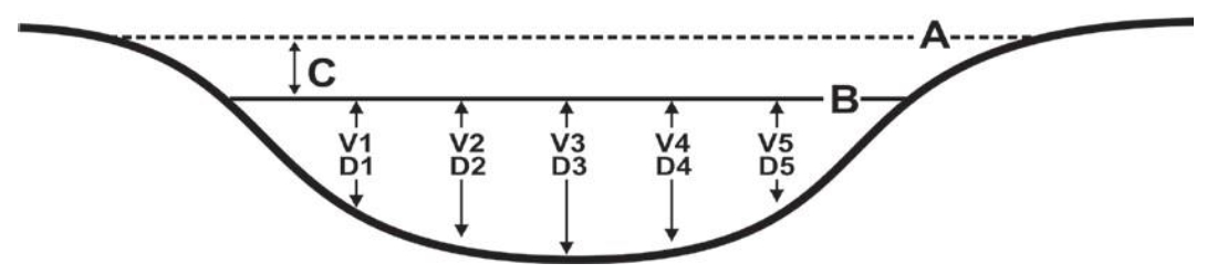
Long description
The image shows a cross-section diagram of a stream, displaying wetted and bankfull widths and bankfull-wetted depth, plus five depth/velocity equidistant measurement points.
Note:
Wetted widths > 5 m, measure a minimum of 5-6 equidistant locations.
Wetted widths < 5 m, measure 3-4 equidistant locations.
Velocity and depth
Check appropriate velocity measuring device and fill out the appropriate section in chart below. Distance from shore and depth are required regardless of method:
▢ Velocity Head Rod (or ruler): Velocity Equation (m/s) = √ [ 2(∆D/100) * 9.81]
▢ Rotary meters: Gurley/Price/Mini-Price/Propeller (Refer to specific meter conversion chart for calculation)
▢ Direct velocity measurements:
- ▢ Marsh-McBirney
- ▢ Sontek or
- ▢ Other_________________
| 1 | 2 | 3 | 4 | 5 | 6 | AVG | |
|---|---|---|---|---|---|---|---|
| Distance from Shore (m) | |||||||
| Depth (D) (cm) | |||||||
| Velocity Head Rod (ruler) | |||||||
| Flowing water Depth (D1) (cm) | |||||||
| Depth of Stagnation (D2) (cm) | |||||||
| Change in depth (ΔD=D2-D1) (cm) | |||||||
| Rotary meter | |||||||
| Revolutions | |||||||
| Time (minimum 40 seconds) | |||||||
| Direct Measurement or calculation | |||||||
| Velocity (V) (m/s) | |||||||
Substrate data
1. 100 pebble count and substrate embeddedness
- Measure the intermediate axis (100 rocks) and embeddedness (10 rocks) of substrate in the stream bed.
- Indicate B for bedrock, S for sand/silt/clay (particles < 0.2 cm) and O for organic material.
- Embededness categories (E):
- Completely embedded = 1
- 75% embedded = ¾
- 50% embedded= ½
- 25% embedded = ¼
- Unembedded = 0
2. Surrounding/interstitial material
Circle the substrate size category for the surrounding material.
| Substrate Size Class | Category |
|---|---|
| Organic Cover | 0 |
| < 0.1 cm (fine sand, silt or clay) | 1 |
| 0.1-0.2 cm (coarse sand) | 2 |
| 0.2-1.6 cm (gravel) | 3 |
| 1.6-3.2 cm (small pebble) | 4 |
| 3.2-6.4 cm (large pebble) | 5 |
| 6.4-12.8 cm (small cobble) | 6 |
| 12.8-25.6 cm (cobble) | 7 |
| > 25.6 cm (boulder) | 8 |
| Bedrock | 9 |
| Diameter (cm) | E | Diameter (cm) | E | Diameter (cm) | E | Diameter (cm) | E | ||||
|---|---|---|---|---|---|---|---|---|---|---|---|
| 1 | 26 | 51 | 76 | ||||||||
| 2 | 27 | 52 | 77 | ||||||||
| 3 | 28 | 53 | 78 | ||||||||
| 4 | 29 | 54 | 79 | ||||||||
| 5 | 30 | 55 | 80 | ||||||||
| 6 | 31 | 56 | 81 | ||||||||
| 7 | 32 | 57 | 82 | ||||||||
| 8 | 33 | 58 | 83 | ||||||||
| 9 | 34 | 59 | 84 | ||||||||
| 10 | 35 | 60 | 85 | ||||||||
| 11 | 36 | 61 | 86 | ||||||||
| 12 | 37 | 62 | 87 | ||||||||
| 13 | 38 | 63 | 88 | ||||||||
| 14 | 39 | 64 | 89 | ||||||||
| 15 | 40 | 65 | 90 | ||||||||
| 16 | 41 | 66 | 91 | ||||||||
| 17 | 42 | 67 | 92 | ||||||||
| 18 | 43 | 68 | 93 | ||||||||
| 19 | 44 | 69 | 94 | ||||||||
| 20 | 45 | 70 | 95 | ||||||||
| 21 | 46 | 71 | 96 | ||||||||
| 22 | 47 | 72 | 97 | ||||||||
| 23 | 48 | 73 | 98 | ||||||||
| 24 | 49 | 74 | 99 | ||||||||
| 25 | 50 | 75 | 100 | ||||||||
Note: The Wolman D50 (i.e. median diameter), Wolman Dg (i.e. geometric mean diameter) and the % composition of the substrate classes will be calculated automatically in the CABIN database using the 100 pebble data. All 100 pebbles must be measured in order for the CABIN database tool to perform substrate calculations.
Site inspection
Site Inspected by: _______________________________________
Communication information
▢ Itinerary left with contact person (include contact numbers)
Contact Person: _____________________ Time checked-in: _________
Form of communication:
▢ radio
▢ cell
▢ satellite
▢ hotel/pay phone
▢ SPOT
Phone number: ( ) _______________
Vehicle safety
▢ Safety equipment (first aid, fire extinguisher, blanket, emergency kit in vehicle)
▢ Equipment and chemicals safely secured for transport
▢ Vehicle parked in safe location; pylons, hazard light, reflective vests if necessary
Notes: _______________
Shore and wading safety
▢ Wading Task Hazard Analysis read by all field staff
▢ Wading Safe Work Procedures read by all field staff
▢ Instream hazards identified (i.e. log jams, deep pools, slippery rocks)
▢ PFD worn
▢ Appropriate footwear, waders, wading belt
▢ Belay used
Notes: _______________
CABIN Field Sheet April 2023