
Gulf of Maine quarterly climate impacts and outlook: June 2015
Gulf of Maine Region, June 2015
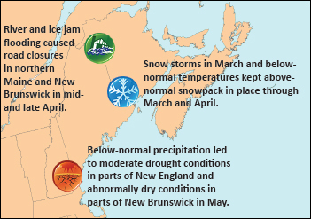
Gulf of Maine Significant Events - for March-May 2015
Several strong storms hit the region in March and April. A storm from March 14 to 15 dropped up to 60 cm (24 in.) of snow and 40 mm (1.60 in.) of rain. Winds gusted to 90 km/h (56 mph) in all three provinces, with a peak gust of 167 km/h (104 mph) in Grand Etang, NS. Moncton, NB, reported 12 hours of blizzard conditions. From March 17 to 18, another blizzard brought up to 50 cm (20 in.) of snow to Nova Scotia. A nor’easter from March 21 to 22 brought up to 36 cm (14 in.) of snow to the provinces. Blizzard conditions were reported for 18 hours in Bas Caraquet, NB, with seven hours of zero visibility. A storm from April 21 to 22 dropped up to 108 mm (4 in.) of rain, with wind gusts to 87 km/h (54 mph). Flood levels were exceeded along the St. John River in New Brunswick, leading to road closures. In addition, a ferry was unable to dock in Digby, NS, for 12 hours because of rough seas.
Above-normal snow depth lingered through March and April across the region. New Brunswick’s average snow depth at the end of March was five times normal. The Saint John airport had over 1 m (3 ft) of snow on the ground by March 31 compared to the normal 5 cm (2 in.). Several U.S. sites ranked their average March snow depth among their top five all-time greatest. The combination of snowpack and additional March precipitation contributed to multiple roof collapses throughout the region. At the end of April, Bas Caraquet, NB, still had record-deep snow, with 76 cm (30 in.) on the ground compared to the normal 2 cm (1 in.). Saint John, NB, and Charlottetown, PEI, had their greatest total snowfall (November-April) on record.
In mid-April, ice jams caused flooding in northern Maine and northwestern New Brunswick. Multiple roads were closed in both areas. A mandatory evacuation order was put in place in Perth-Andover, NB, for two days, with a state of emergency also in place for several days.
Severe thunderstorms struck the region in late May. Heavy rain caused flash flooding, and marble-sized hail was reported. Strong winds downed trees, caused thousands of power outages, and damaged homes and cars. A microburst with winds to 113 km/h (70 mph) occurred in Essex County, MA.
The abundant snow that fell during winter had near- to below-normal water content in many areas; therefore, overall winter precipitation was near to below normal. Despite multiple storms, spring precipitation was also below normal. Dry conditions led to moderate drought in parts of New England and to abnormal dryness in parts of New Brunswick in May.
Long description for Signifcant Events map
This map shows the Gulf of Maine Region, including Massachusetts, New Hampshire, Maine, New Brunswick, Nova Scotia, Prince Edward Island, and the nearby marine areas. The following highlights are noted:
- Snow storms in March and below normal temperatures kept above normal snowpack in place through March and April.
- River and ice jam flooding caused road closures in northern Maine and New Brunswick in mid and late April.
- Below-normal precipitation led to moderate drought conditions in parts of New England and abnormally dry conditions in parts of New Brunswick in May.
Regional Climate Overview - for March-May 2015
Temperature
Departure from Normal
Long description for Temperature map
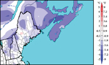
The Temperature Departure from Normal map of the Gulf of Maine region shows the temperature departure from normal, averaged over March, April, and May 2015. The three Maritime provinces were much colder than normal with sections of Nova Scotia as cold as 3°C (5.4°F) below normal. The three month average temperature for New England ranged from 0° to 2°C (0 to 3.6°F) below normal.
Spring temperatures (averaged over March, April, and May) ranged from near normal to 3°C (5.4°F) below normal. March was quite cold, with temperatures 2°C (3.6°F) to 5°C (9°F) below normal. For instance, Fredericton, NB, had only four days with temperatures above the freezing mark, compared to 22 days normally. April temperatures ranged from near normal in Massachusetts to 3°C (5.4°F) below normal in the Maritimes. April 6 was particularly cold, with 10 sites in New Brunswick setting or tying daily record lows and Caribou, ME, having its all-time lowest April temperature. May was quite warm, with temperatures 1°C (1.8°F) to 4°C (7.2°F) above normal. Massachusetts and New Hampshire each had a record-warm May, while Maine had its third warmest.
Temperature and precipitation normals based on 1981-2010. Canada and ocean precip data: Canadian Precipitation Analysis. U.S. precipitation data: interpolated station data.
Precipitation
Percent of Normal
Long description for Precipitation map
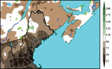
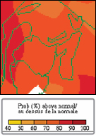
The Precipitation Percent of Normal map for the Gulf of Maine region shows the total precipitation as a percentage of normal precipitation, averaged over March, April, and May 2015. The three month average was below normal in most areas. The driest areas were Massachusetts, southern New Hampshire, and southwestern Maine which received as little as 25% the normal amount of total precipitation. Other parts of New England received 50% to 90% of the normal amount. Much of New Brunswick, western Nova Scotia and Prince Edward Island generally received 75% to 90% of the normal amount of precipitation, with near normal amounts in the more eastern sections of the Maritimes.
Spring precipitation (accumulated during March, April, and May) ranged from 25% of normal to near normal for most of the region. Massachusetts and New Hampshire had their fourth driest spring. March was extremely dry in the U.S. and New Brunswick, with areas seeing 25-75% of normal precipitation. Maine and New Hampshire ranked this March among their top 12 driest. Conversely, March was wet in Nova Scotia and Prince Edward Island, with areas seeing up to 175% of normal precipitation. April precipitation ranged from 50% of normal in the U.S. to near normal in the Maritimes. May was also extremely dry, with most of the region seeing from less than 25% of normal precipitation to 75% of normal. Massachusetts had its second driest May, while New Hampshire had its 16th driest.
Sea Surface Temperatures
Departure from Normal
Long description for Sea Surface Temperatures map
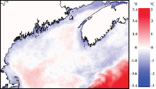
The Sea Surface Temperature Departure from Normal map of the Gulf of Maine region covers the Bay of Fundy, the Gulf of Maine, and waters south of Nova Scotia. It shows the departure from normal sea surface temperature, averaged over March, April, and May 2015. Sea surface temperatures were as much as 1 °C (1.8°F) below normal over all shallow coastal regions and some offshore areas, with somewhat above normal temperatures over deeper basins. Details of the locations of the cold and warm anomalies are described in the text.
Spring sea surface temperatures in the Gulf of Maine were colder than normal by as much as 1°C (1.8°F) over all shallow coastal regions, especially along the Maine and New Brunswick coasts, southwest Nova Scotia, and Minas Basin. Cold anomalies were also present offshore in the central Gulf of Maine south of Penobscot Bay and over most of the Scotian Shelf. These cold anomalies continued from the strong winter cooling that started in February. Surface water over deeper basins in the Gulf of Maine (Wilkinson and Jordan Basins) still had weak [around 0.5°C (0.9°F)] warm anomalies left over from the strong warm anomalies that were present throughout 2014 and even into winter 2015.
Sea surface temperature anomalies based on 1985-2014. Mean SST anomalies from NOAA AVHRR data. Credit: University of Maine School of Marine Sciences and NERACOOS
Regional Impacts - for March-May 2015
Delayed Spring

Ice flows through the Cape Cod Canal in early March. Credit: Ron Horwood.
Long description for Delayed Spring figure
This figure is a photograph of the Cape Cod Canal looking inland with a bridge in the background. Much of the canal is covered with broken pieces of ice with only limited areas of open water nearer to each side of the canal.
Snow cover remained in place later into spring than normal for much of the region. The start of the growing season was delayed by up to a month, as many fields were too wet or still snow-covered in April. The late spring also contributed to above-average tree pollen counts, leading to a shortened but concentrated allergy season. In April and May, sea ice and frozen harbors around Prince Edward Island, northern Nova Scotia, and western Cape Breton delayed the start of the spring lobster and snow crab seasons by up to 11 days. Shellfish harvesters and ferry services were also delayed by the ice. In Maine, the ice fishing season was extended, but the start of the open water fishing season was delayed.
Nova Scotia’s above-normal snow cover made it difficult for migratory birds and wildlife to find food, causing some to become weak or die. A late snowmelt in northern New England cut short the development period for amphibians that hatch in pools created by melted snow and need several months to grow legs before these pools dry up. Above-normal snowfall likely insulated blacklegged (deer) ticks, which transfer diseases to humans.
Lingering snow cover caused Nova Scotia golf courses to open several weeks late and the Portland Sea Dogs baseball team to postpone their first two games of the season. In Prince Edward Island, snow cover and wet conditions made many seasonal roads impassable and delayed the opening of campgrounds and trails in some provincial parks. The harsh spring kept real estate agents from showing cottages in PEI and delayed new home construction in Nova Scotia. Spring weight restrictions were extended by a week in parts of the Maritimes so roads could recover from frost heaves.
Drought Monitor
Percent normal stream flow map for May from U.S. Geological Survey. Red indicates much below normal (less than 10%), orange indicates below normal (10-24%), and green indicates normal (25-75%).
Long description for Drought Monitor map
This figure is a map of New England showing the stream flow as a percentage of normal for May. It shows much below normal stream flows in Massachusetts, southeastern New Hampshire, southwestern and also parts of southeastern Maine. It shows below normal stream flows nearly everywhere else except near normal stream flows in extreme northwestern sections of New Hampshire and Maine.
Maine, New Hampshire, Massachusetts, and northern New Brunswick were abnormally dry during spring due to a continued lack of precipitation. By late May, moderate drought conditions were present in Massachusetts, southern New Hampshire, and part of southern Maine. Stream flows were much below normal in these areas. Topsoil moisture as of May 31 was rated short or very short in 51% of New Hampshire. U.S. Department of Agriculture crop reports indicated that plant growth was slow due to lack of moisture, with some farmers already irrigating. The dry conditions also contributed to multiple wildfires in Maine and New Hampshire. Wildfires were also reported in Nova Scotia and New Brunswick. Precipitation in early June helped ease dryness in some areas.
Regional Outlook - for Summer 2015
Temperature
Environment Canada map produced on May 31.
Long description for Environment Canada Temperature map
The Environment Canada seasonal outlook map for temperature, produced on May 31, 2015 for the three month period June to August 2015, shows 70% to 80% probability of above normal temperatures over all three Maritime provinces, except probability of over 80% in extreme northwestern sections of New Brunswick.
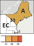
Probability of above-normal
A: Above-normal
EC: Equal chances of above-, near-, or below-normal
33: Probability of above-normal
Climate Prediction Center map produced on May 21.
Long description for Climate Prediction Center Temperature map
The NOAA seasonal outlook map for temperature, produced on May 21, 2015, for the three month period June to August 2015, shows increased chances (33% and 40% probability) of above normal temperatures over northeastern New Hampshire and over Maine. It shows equal chances of above, near, or below-normal temperatures over southwestern New Hampshire and over Massachusetts.
For June through August, Environment Canada is predicting an increased chance of above-normal temperatures for the Maritimes. NOAA’s Climate Prediction Center is forecasting an increased chance of above-normal temperatures for Maine, northern and eastern New Hampshire, and part of Cape Cod. Equal chances are forecast elsewhere.
Precipitation
Environment Canada and NOAA’s Climate Prediction Center are both predicting equal chances of above-, near-, or below-normal precipitation for June through August.
Drought
Issued: June 18, 2015
Drought conditions were expected to improve during summer in Massachusetts, southern New Hampshire, and southern Maine. According to the Climate Prediction Center, conditions should improve “due to the proximity of the summer storm track, and the overall historical tendency for above-median precipitation during the past 10 to 15 summers.”
El Niño
Issued: June 11, 2015
During May, ongoing and strengthening El Niño conditions were observed in the equatorial Pacific. NOAA’s Climate Prediction Center says there is a 90% chance of El Niño continuing through fall, with an 85% chance of it continuing through winter. El Niño impacts in the region are generally weak or insignificant, especially during summer. However, El Niño does impact hurricane activity.
Atlantic Hurricane Season
Issued: May 27, 2015
While the 2015 Atlantic hurricane season got an early start with Tropical Storm Ana in May, NOAA is predicting that the season will likely be below normal. There is a 70% chance of 6-11 named storms. Of the named storms, 3-6 could become hurricanes, with 0-2 of those becoming major hurricanes. The main driver of the forecast is El Niño, which is expected to help suppress hurricane development.
Gulf of Maine Region Partners
- Environment Canada
- Northeast Regional Climate Center
- National Oceanic and Atmospheric Administration
- Gulf of Maine Research Institute
- State Climatologists
- National Integrated Drought Information System
- Cooperative Institute for the North Atlantic Region
- Gulf of Maine Council on the Marine Environment, Climate Network
- Northeastern Regional Association of Coastal and Ocean Systems
- University of Maine, School of Marine Sciences
Contacts
NOAA:
Ellen Mecray
Samantha Borisoff
Environment Canada:
1-800-668-6767 (in Canada only)
819-997-2800 (long-distance charges apply)
Sign up to receive this publication every quarter.