
Disposal at sea permit application guide: disposal site selection, assessments
Scientific and technical assessments for selection of disposal at sea sites
If disposal at sea is found to be the appropriate management option, potential disposal sites must be identified and characterized to understand the potential impacts on the receiving environment. The Disposal at Sea Program strives to minimize the number of active disposal at sea sites so that potential impacts associated with disposal at sea activity are spatially limited and monitoring efforts are focused and effective. Existing sites should always be considered first when preparing a disposal at sea permit application.
However, in those cases where use of an existing site is not operationally feasible or other issues preclude its selection as the most appropriate disposal at sea site, new candidate disposal sites must be identified and characterized. Some primary concerns that need to be addressed when applying for a new disposal site are:
- alterations to the physical environment
- risks to human health
- devaluation of marine resources, and
- interference with other legitimate uses of the sea
The 5 steps of disposal site selection are shown in Figure 1.
Figure 1: Disposal at sea site selection process
Step 1
Identification of candidate Sites
What is the zone of siting feasibility?
Constraint mapping:
Where are environmentally sensitive areas?
Where are areas of incompatible uses?
Where are areas potentially suitable for disposal (candidate sites)?
Step 2
Characterization of the candidate sites
Physical, chemical, and biological environment
Other uses of the sites and nearby areas
Step 3
Assessment of potential impacts at candidate sites
What are the near and far-field effects?
What are the short and long-term effects?
Step 4
Comparison of candidate sites
Compare potential adverse effects at each site
Evaluate compatibility with other uses
Assess acceptability of potential adverse impacts at the sites
Identify applicable management and monitoring techniques
Step 5
Preparation of the site monitoring and management plan
Identify compliance monitoring and field monitoring requirements
Identify management measures to manage potential impacts
Step 1: Identification of candidate sites
- What is the zone of siting feasibility?
- Constraint mapping:
- where are environmentally sensitive areas?
- where are areas of incompatible uses?
- where are areas potentially suitable for disposal (candidate sites)?
Zone of siting feasibility
Sites for disposal at sea must be located in areas where disposal will not cause unacceptable impacts to the environment or to other uses of the sea. In order to effectively locate sites within potentially acceptable areas, the initial consideration should be of factors affecting the operational feasibility of using a site.
The zone of siting feasibility is the area within a feasible radius from the point of loading onto the vessel, and is determined by consideration of such factors as:
- seasonal weather restrictions and type of disposal vessel, or equipment that will be utilized
- navigation restrictions
- operational and transport costs to the site
- political boundaries
- feasibility of surveillance and monitoring.
However, these considerations can be overridden by environmental or other practical concerns if all candidate disposal site locations within the zone of siting feasibility would result in unacceptable impacts. Alternate sites at greater distances should be considered when they offer environmental benefits at reasonable increases in costs.
When seasonal conditions limit the dredging schedule, practical considerations may also limit distances between the dredging site and the disposal site so that transit times do not unduly prolong the dredging cycle. Some seagoing barges and hopper dredges have a limited range of operation, defined primarily by safety considerations.
Once the zone of siting feasibility is established, a constraint mapping exercise can be undertaken in consultation with Disposal at Sea Program staff, other federal, provincial, territorial, and municipal government departments, Aboriginal groups and stakeholders as appropriate. Constraint mapping entails the identification of environmentally sensitive areas and potentially incompatible uses within the zone of siting feasibility.
Constraint mapping: environmentally sensitive areas
Sensitive areas are those areas where natural resources could be adversely affected by disposal at sea, including, but not limited to:
- commercial, recreational, or aboriginal fish or shellfish habitat
- spawning grounds and habitat of important species and their food organisms
- migration routes of finfish or whales and other marine mammals
- habitat for species at risk
- areas supporting nesting marine-associated avifauna, including seabird colonies
- areas supporting moulting, over-wintering, and staging marine-associated avifauna
- proximity to areas of special scientific or biological importance, such as marine sanctuaries or marine reserves
Concerns about the location of a disposal site will likely focus upon the species of local significance and unique habitats or environmental features that ensure their continued viability. Sensitive habitats near the candidate site need to be identified, such as areas with abundant submerged aquatic vegetation or rocky outcrops. In addition, nearshore habitats should be identified including coastal marshes, wetlands, kelp beds, and habitats that provide important habitat for juvenile and adult phases of sensitive species. These features should be identified and overlain on a map within the zone of siting feasibility.
Constraint mapping: areas of potentially incompatible uses
Potentially incompatible uses should also be identified and overlain on the map within the zone of siting feasibility. Consultation with relevant federal, provincial, territorial, and municipal government departments, Aboriginal groups, and stakeholders as appropriate should be conducted to determine the significance and potential implications of “other uses” if a disposal site was situated within the same area. Potentially incompatible uses include, but are not limited to:
- proximity to Aboriginal traditional uses in the vicinity of the candidate disposal sitesFootnote 1
- archeological or other features in close proximity to natural or other features of historical or cultural importance, and areas of high aesthetic value
- beaches and water sports
- engineering uses of the sea floor, including mining, pipelines, water intake structures or undersea cables
- navigation and shipping lanes
- military training and exclusion zones (for example, given presence of unexploded ordinances)
- mineral extraction
- aquaculture sites
- public use of the shoreline
- prospective oil and gas exploration and development
- commercial, recreational and Aboriginal fisheries
- commercial diving sites
Some of the above uses may require the application of certain management measures to reduce possible impacts or possibly a buffer zone around them to ensure that they are adequately protected.
Constraint Mapping: selection of candidate disposal sites
Once the constraint mapping exercise is completed, and sensitive areas and areas of incompatible uses are consolidated onto a map within the zone of siting feasibility, the available areas for candidate disposal sites should become more apparent, as in example maps of Figures 2 and 3. Existing sites should always be considered first. Whenever possible, sites should be selected which have been previously used for disposal of similar material.
If no potentially suitable disposal sites can be identified in the zone of siting feasibility, the geographic region under consideration may be enlarged. If this is not feasible, the use of land-based alternatives may need to be reconsidered for disposal.
The location and size of the disposal site are important issues to assess. Information is required to demonstrate that the candidate sites are:
- large enough that the bulk of the deposited material would remain either within the site limits or within a predicted area of impact after disposal while ensuring that the area impacted is nonetheless minimized
- this would not apply for sites selected for dispersive characteristics
- large enough in relation to anticipated disposal volumes that it would serve its function for many years
- small enough to ensure that environmental impacts can be predicted and effective monitoring can be conducted in future.
During the selection of candidate sites, consultation should be occurring with the relevant federal, provincial, territorial, and municipal government departments, Aboriginal groups, and stakeholders as appropriate and necessary to confirm that candidate sites are feasible prior to further study or data collection.
In the event that no constraints are identified, applicants should propose sites that are suitable for the material to be disposed. The following general characteristics have been found to minimize impacts to the marine environment:
- deeper sites may be less dispersive and have less diverse biological communities
- level sites are generally more stable
- higher energy sites are more suitable for disposal of material that may generate Biochemical Oxygen Demand (BOD), for example, fish waste and organic matter
- stable sites are generally more suitable for excavated and dredged material
Figure 2: Example of constraint mapping within zone of siting feasibility to identify candidate disposal sites (US EPA 2012)
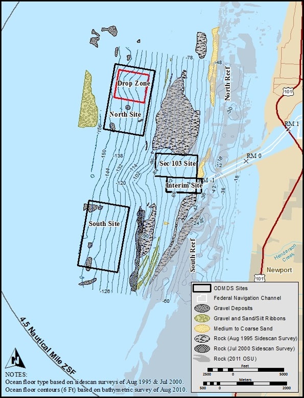
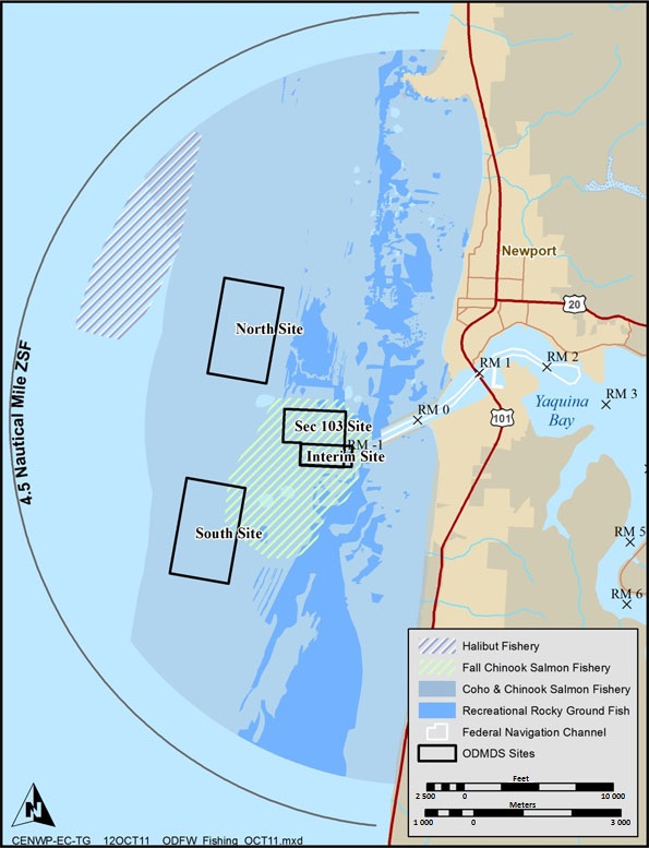
Description of Figure 2
An example of constraint mapping taken from a US EPA report (2012) showing Yaquina Bay on the Oregon coast. The first map shows a coastal area with the location of 2 candidate disposal sites in relation to recreational fishing areas (halibut, salmon and rocky ground fish) in the vicinity. The second map shows the same coastal area overlaid with areas of human-powered recreation activities (that is, kayaking, surfing, swimming, snorkeling and Scuba diving), as well as the types of bottom substrate (gravel, sand, silt and rock).
Figure 3: Map demonstrating the proposed disposal site in relation to potential shipwrecks, fishing and shellfishing areas in the vicinity (US EPA 2008)

Description of Figure 3
In another example of constraint mapping, the map of the Oregon coast taken from a US EPA report (2008) demonstrates a coastal disposal site surrounded by commercial and recreational fishing areas for salmon, halibut, crab and reef fish, as well as areas with potential shipwrecks.
Step 2: Characterization of the candidate sites
- Physical, chemical, and biological environment
- Other uses of the sites and nearby areas
Description of the characteristics of the candidate disposal sites
Once constraint mapping is complete and candidate sites are identified in consultation with federal, provincial, territorial, and municipal government departments, Aboriginal groups and stakeholders, a detailed description of the characteristics of each site is needed. Information on historical uses of the site and the surrounding area should be collected as part of this effort. Information needed includes:
1. General site characteristics
- Latitude and longitude of the centrepoint of the candidate sites in decimal degrees to 5 decimal places, located on a map and should include proposed site boundaries (this may vary for dispersive sites)
- each candidate site should have a name
- Historical disposal activities at or near the site
- Present and historical uses of, or events at or near the site that could impact sediment quality
- Site characteristics or activities that could affect movement of sediments
- Any recent or historical spill events
2. Physical, chemical, and biological environment
Information regarding the physical, chemical, and biological characteristics of the water column and the seabed are required for candidate sites as follows, and in Appendix C.2 quick reference guide:
a. Water column
Physical characteristics
- Detailed bathymetry of the candidate sites and surrounding areas
- Expected water temperature and salinity at the time of disposal and any relevant temporal and seasonal fluctuations
- Expected background turbidity and natural fluctuations at the time of disposal and any relevant temporal and seasonal fluctuations
- Assessment of the seasonal current flow, tidal cycles, wave climate, and upwelling at the candidate disposal sites, and identification of whether the disposal site is non-dispersive or dispersive
- Consideration should be given to:
- short term measurements of current (that is, during the disposal action) have little validity in determining the transport of fines either in the water column or sediment on the sea floor
- long term measurements of currents (that is, post-disposal, once the sediment has settled) may be necessary to refine the estimates of the dispersion of disposed materials
- other current and wave information may be required including:
- tidal period and orientation of the tidal ellipse
- mean direction and velocity of the surface and bottom drifts
- velocities of storm-wave induced bottom currents
- general wind and wave characteristics
- average number of storm days per year
Biological characteristicsFootnote 2
- Proximity to spawning, feeding, nursery, recruitment, migration, and other important habitats
- A description of fisheries resources including known sensitive species, such as at risk species (for example, those listed on the Species at Risk Act), or habitat at or near the load site(s); as well as communities and migratory species in the vicinity of the disposal site
- Temporal and seasonal and spatial characteristics should be considered, to identify potentially critical times or circumstances when disposal should not take place including:
- periods of migration from one part of an ecosystem to another
- growing, feeding, resting and breeding periods of sensitive or threatened speciesFootnote3
- Temporal and seasonal and spatial characteristics should be considered, to identify potentially critical times or circumstances when disposal should not take place including:
b. Sediment
Physical characteristics
- Particle size and total organic carbon (TOC)
- Percent (%) moisture
- Other parameters may be required based on site specific characteristics
Chemical characteristics
Refer to Appendix C.4 table for minimum sample analytical requirements.
- Mercury (Hg), cadmium (Cd), lead (Pb), copper (Cu) other heavy metals
- High molecular weight hydrocarbons, for example, petroleum hydrocarbons
- Total polychlorinated biphenyls (PCBs) and total polycyclic aromatic hydrocarbons (PAHs)
- Other contaminants of concern may need to be characterized based on site history, for example, polybrominated diphenyl ethers (PBDEs), dioxins and furans, chlorinated pesticides and nutrients
c. Biota
Biological characteristicsFootnote4
Marine habitats and the benthic community should be enumerated and characterized using appropriate sampling techniques. Sampling plans are to be submitted to the Disposal at Sea Program for review prior to conducting baseline studies.
Consideration of other uses of the sites or nearby areas
Consideration should be given as to whether potentially incompatible uses at candidate sites could be mitigated by management measures. In addition, an assessment on the need for further consultations with government, Aboriginal groups and stakeholders should be made once the initial physical, chemical and biological data are available.
Step 3: Assessment of potential impacts at candidate sites
- What are the near and far-field effects?
- What are the short and long-term effects?
The candidate site or sites should be evaluated to determine potential adverse effects of the disposal activity (see also the list of considerations below if there are any future predicted uses of a proposed disposal site). Comprehensive testing of the waste material prior to evaluation of candidate disposal sites should provide details on its characteristics including the presence and mobility of contaminants. In addition, the quantities of material to be disposed should be specified along with information on disposal management options.
Information required:
- maximum quantity per disposal load in cubic metres or metric tonnes
- rate of disposal in cubic metres or metric tonnes per hour or per day
- frequency of disposal events per day, week, or month
- speed during disposal in knots or kilometres per hour
- time required for disposal event
- track followed during disposal event
- duration to complete all disposal activity for the project.
The evaluation of the potential effects of disposal of the waste material and its constituents must consider:
- near and far field fates (spatial effects), and
- short and long term effects (temporal effects) on marine resources and the environment.
The expected consequences of disposal should be described in terms of the habitats, processes, species, communities and uses that are expected to be affected. The precise nature of the predicted effect (for example, change, response, or interference) should be described. Assessment of the potential effects should lead to a concise statement of the expected consequences of the disposal activity that is, the ‘Impact Hypothesis.’ For sample impact hypotheses, see the quick reference guide in Appendix C.2.
The impact hypothesis should integrate information on the type and characteristics of the material to be disposed, the proposed disposal site conditions and pathways of concern including:
- nature of the sea bed:
- including its topography, geochemical and geological characteristics, data on benthic communities including fisheries resources and prior disposal activities in the area
- physical nature of the water column:
- including depth, temperature, the possible existence of a pycnocline and thermocline, currents (tidal, wave-induced, residual), and suspended matter where these characteristics may affect sediment transport at the site
- chemical and biological nature of the water column:
- including pH, salinity, dissolved oxygen, nutrients, primary productivity, contaminant concentrations, for example, trace metals
- biological and ecological effects of the disposal of the waste material:
- including toxicological and bioaccumulation effects, changes in community structure, disruption of ecological processes, degradation of water and sediment quality and alteration of sediment characteristics
- these possible effects must be considered within the disposal site and in the area that could be influenced by the disposed material.
Quantitative analysis to address impacts of Total Suspended Solids (TSS) in sensitive environments includes physical tests of basic sediment characteristics to predict the behaviour of material after loading and disposal. This would include full grain size analysis for prediction of turbidity plume characteristics during and after disposal, and to assess whether the material proposed for disposal is physically different than the substrate at the disposal site. This analysis supports the prediction of post-disposal behaviour of the waste material. For the purpose of habitat protection, it is advantageous to seek compatibility between the physical characteristics of the load site material and the sediment type at the disposal site.
The method of loading (for example, hydraulic or mechanical dredge) and disposal (for example, hopper discharge or discharge through marine-based pipes) can alter the characteristics of the material; therefore, it is important to determine physical, chemical, and biological characteristics as the material is released from the disposal vessel, in addition to the in situ characteristics. The most important physical characteristics are grain size distribution and the cohesiveness or degree of consolidation.
Important considerations:
- Dispersion direction and distance of associated plumes:
- fine fractions associated with the material may remain in suspension in the water column and be transported to threaten sensitive areas or interfere with other uses
- Erodability; once the material reaches the sea floor depending on its physical characteristics, it may remain there or be eroded and moved by currents to affect sensitive areas
- Shoaling; some material (for example, consolidated clay or rocks) may not move from where it is deposited and shoaling may occur
- it must be determined whether the site can accommodate this and future material without any adverse effects.
Cumulative effects must also be considered when repeated or multiple disposal operations occur. You must consider possible interactions with other disposal at sea activities in the area, including historical, existing, and planned disposals. In some cases, disposal at sea can augment existing effects attributable to inputs of contaminants to coastal waters through land runoff and waste water discharges, from the atmosphere, resource extraction, and other sources such as maritime transport. These existing stresses on biological communities should be considered as part of the assessment of potential impacts caused by disposal at sea activities.
Where existing information is absent or inadequate, site-specific field work is required to address the gaps. Computer modeling may be needed to predict water and sediment movements.Footnote 5
At a non-dispersive site, the impact assessment will delineate the area that will be altered by the disposed material and identify effects to the area. In most cases, the primary impact zone will be entirely smothered. The assessment should project the likely time scale of recovery or recolonization after disposal, as well as the nature of recolonization (that is, whether the benthic community structure will be altered). The assessment should also specify the likelihood, scale, and severity of residual impacts outside this primary zone.
At a dispersive site, the impact assessment will define the area likely to be altered in the short and long term and the severity of any changes. Applicants should also specify the likely extent of long term transport of material from the disposal site, compare this flux with existing transport fluxes in the area and assess the likely scale and severity of effects in the long term. In some cases, disposal of fine-grained material at dispersive sites within, and close to, estuaries or in the littoral zone, along the coastline, can have beneficial effects for habitats and species by maintaining sediment budgets.
Step 4: Comparison of candidate sites
- Compare potential residual adverse effects at each candidate site
- Evaluate compatibility with other uses
- Assess acceptability of potential adverse impacts at the sites
- Identify applicable management and monitoring techniques
At this stage of the site selection process, a comparison of the potential adverse effects at each candidate site or sites needs to be undertaken. An analysis of each candidate site should be considered in light of a comparative assessment of human health risks, environmental impacts, hazards (including accidents), economics and exclusion of future uses.Footnote6 The quick reference guide in Appendix C.2 has examples of questions to consider in comparing the potential impacts and conflicts to the other uses of the site and surrounding areas. If this assessment reveals that adequate information is not available to determine, with confidence, the likely effects of the proposed disposal at the candidate disposal sites, including potential long-term harmful consequences, then these candidate sites should not be considered until sufficient information is available.
If 2 or more candidate sites have been identified as acceptable, a comparison then needs to be carried out to evaluate the relative impacts of disposal activities at each site. This should include quantitative and qualitative evaluations of the perceived risks. For example:
- Quantitative comparisons of predicted water-quality characteristics to established criteria
- Quantitative comparisons of the sediment transport modeling results and predicted areas of impact resulting from disposal
- Proximity to sensitive resources; timing limitations, operational feasibility
- Comparison of other site characteristics as appropriate for the site
Risk assessment models covering human health effects and environmental impacts and resource damages can also be used to compare sites.Footnote7
Once the likelihood and consequences of potential impacts of disposal have been predicted, management measures should be evaluated to determine if the impacts can be controlled or mitigated. For candidate disposal sites where impacts to marine life are considered unacceptable during certain times of the year, management provisions should be considered. You must identify potentially critical times of the year (that is, for marine life) when disposal operations should not take place. This consideration should determine periods when it is expected that disposal operations will have less impact than at other times. Managing the exposures and risks associated with disposal during critical times can also be addressed through the use of engineering and operational controls. Biological considerations relative to the timing of disposal operations include:
- periods when marine organisms are migrating from one part of the ecosystem to another, for example, from an estuary to open sea or vice versa
- growing and breeding periods
- periods when marine organisms are hibernating on or are buried in the sediments
- periods when particularly sensitive and at risk species are exposed
Candidate sites for which the assessment has shown that disposal would result in unacceptable impacts, even with management measures applied, can be eliminated from the process. If no sites are acceptable, then the parameters of acceptance need to be reconsidered or no site can be selected for disposal at sea in the zone of siting feasibility.
The final decision regarding the acceptability of a proposed disposal site is determined by the Disposal at Sea Program during the permit application and regulatory review phase. If you're seeking to dispose material at a site that already exists, and no major issues have been raised by government departments, Aboriginal groups and stakeholders during the constraint mapping exercise, site selection may be relatively straightforward. For projects where either there are no existing sites, or where a new site is proposed rather than using one that already exists within the zone of siting feasibility, the permit application and regulatory review phase may be more complex and require additional time in order to collect, interpret and assess the supporting information and consult with relevant parties.
Step 5: Preparation of the site monitoring and management plan
- Identify compliance monitoring and field monitoring requirements
- Identify management measures to manage potential impacts
While an applicant is responsible for preparation of a site monitoring and management plan (the plan) for the selected disposal site as part of the permit application, the Disposal at Sea Program is responsible for implementation and delivery of the post-disposal monitoring program, and any subsequent management actions required at a site (for example, site closure).
The plans should set out the framework for management, mitigation, and monitoring of impacts during project implementation. They should detail the control strategies for the project, including environmental objectives, auditable performance criteria, and corrective actions. The plans should include:
- management objectives relating to possible adverse effects that could develop at the disposal site
- consideration of the times, rates, quantities, and types of material disposed
- consideration of the various methodologies of monitoring the movement and characteristics of the disposed material during project activities
- impact hypotheses and a tiered approach for monitoring disposal operations
- target thresholds and associated response measures that may be applied should the project implementation monitoring indicate outcomes significantly different than expected.
Management measures may include:
- directed disposal within the disposal site
- to avoid or reduce impacts on sensitive benthic communities, which depends upon the equipment used and the ability to control disposal in the disposal site
- altering the time of year of operations
- to avoid critical life-cycle phases of sensitive marine organisms
- loading and disposal management
- to reduce dispersal of turbid plumes in sensitive environments, which depends upon the availability of suitable equipment
- thin layer disposal
- to improve recolonization by benthic organisms
The quick reference guide in Appendix C.2 has a summary of the plan components and measures. The template outline for the plan is also presented in Appendix C.3, with main headings as follows:
- Description of project
- Anticipated use of site
- Goals and objectives of the management plan
- Regulatory regime
- Roles and responsibilities
- Description of the existing environment
- Description of the material for disposal
- Description of potential impact
- Consultation and engagement
- Disposal site history
- Project implementation monitoring
- Management measures, conditions or practices
- Target thresholds and associated response measures
- Disposal site monitoring and management plan review and revision
- References