
Canadian Lightning Danger Map: frequently asked questions
Always remember: When thunder roars, GO INDOORS!
Questions and Answers
What is a Canadian Lightning Danger Map?
The Canadian Lightning Danger Map is a map that shows the areas most at risk of lightning reaching the ground. The performance of the map will increase with the number of lightning strikes.
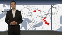
What do the red areas on the Canadian Lightning Danger Map represent?
The Canadian Lightning Danger Map shows the areas that are at immediate risk of being struck by lightning in the next 10 minutes. The risk areas are based on actual lightning strikes that have occurred in the past 20 minutes.
Why are the circles different sizes on the map?
The larger circles correspond to lightning within the past 10 minutes. The smaller circles correspond to lightning within the past 10-20 minutes. The size of the circle does not change the risk of being struck by lightning.
What should I do if there is a red circle over my area?
You should go to a safe location immediately, either a building with plumbing and wiring or an all metal vehicle. Stay there for 30 minutes following the last rumble of thunder.
What should I do when I hear thunder?
When you hear thunder you should go to a safe location, either a building with plumbing and wiring or an all metal vehicle. Stay there for 30 minutes following the last rumble of thunder.
Is it safe to go outside once a thunderstorm has begun to move away and thunder is less frequent?
No. Research in North America shows that 1/3 of lightning injuries and fatalities occur in the early stages of a storm, 1/3 at the peak of a storm and 1/3 once the peak of the storm has passed by. It is recommended that you remain in a safe location, either a building with plumbing and wiring or an all metal vehicle, for 30 minutes following the last rumble of thunder.
I heard thunder and saw lightning but nothing appears on the lightning danger maps. Why?
Firstly, if you hear thunder, seek safe shelter immediately. And stay there for 30 minutes until after the last rumble of thunder.
Secondly, what you likely saw was in-cloud lightning or cloud-to-cloud lightning. This type of lightning does not contact the ground but it is a warning signal to find safe shelter quickly.
What is the time interval between the Canadian Lightning Danger Maps?
The interval between maps is 10 minutes.
Thunderstorms are in the forecast for my location, but the Canadian Lightning Danger Map does not show that my location is at risk. Why is there a difference?
Risk areas on the map are based on observations of lightning during the past 20 minutes. However a forecast of thunderstorms is a general alert of the potential for thunderstorms and their associated lightning to develop in the region.
When thunderstorms are forecast you should keep an eye on the sky and be prepared to go to a safe location should thunder be heard. This also applies if thunderstorms have already been observed at your location as more storms may still develop later in the day. When lightning begins to strike in your area, the Canadian Lightning Danger Map will reflect the lightning risk.
Is the Canadian Lightning Danger Map a forecast of lightning?
No. The Canadian Lightning Danger Map is based on lightning that has occurred in the past 20 minutes. It is valid for 10 minutes from the time at which the map is produced.
Why doesn’t the Canadian Lightning Danger Map display actual lightning strikes?
Displaying individual lightning strikes would not fully illustrate the area that is at immediate risk of lightning. Lightning research has shown that successive lightning strikes occur on average within an area of 5 to 8 kilometres, and within 5 minutes, from the previous strike.
How do I use the Canadian Lightning Danger Map?
Please follow the link to “How to Use the Canadian Lightning Danger Map” for detailed instructions.
What time zone is used?
The national and regional displays will use UTC (Coordinated Universal Time). For more information see Time Zones and Coordinated Universal Time (UTC)
Page details
- Date modified: