
Bird conservation strategy for Region 8: Prairie and Northern boreal softwood shield
Table of Contents
- Abridged version -
July 2014

- Preface
- Acknowledgements
- Bird Conservation Strategy for Bird Conservation Region 8 in Prairie and Northern Region: Boreal Softwood Shield
- Executive suummary
- Introduction: Bird Conservation Strategies
The abridged version of the strategy available here contains a summary of the results, but does not include an analysis of conservation needs by habitat, a discussion of widespread conservation issues, or the identification of research and monitoring needs.
To obtain a copy of the full version of this strategy, please contact migratorybirds_oiseauxmigrateurs@ec.gc.ca.
Preface
Environment and Climate Change Canada led the development of all-bird conservation strategies in each of Canada’s Bird Conservation Regions (BCRs) by drafting new strategies and integrating new and existing strategies into an all-bird framework. These integrated all-bird conservation strategies will serve as a basis for implementing bird conservation across Canada, and will also guide Canadian support for conservation work in other countries important to Canada’s migrant birds. Input to the strategies from Environment and Climate Change Canada’s conservation partners is as essential as their collaboration in implementing their recommendations.
Environment and Climate Change Canada has developed national standards for strategies to ensure consistency of approach across BCRs. Bird Conservation Strategies will provide the context from which specific implementation plans can be developed for each BCR, building on the programs currently in place through Joint Ventures or other partnerships. Landowners including Aboriginal peoples will be consulted prior to implementation.
Conservation objectives and recommended actions from the conservation strategies will be used as the biological basis to develop guidelines and beneficial management practices that support compliance with regulations under the Migratory Birds Convention Act, 1994.
Acknowledgements
Jean-Michel DeVink was the main author of this document that follows templates developed by Alaine Camfield, Judith Kennedy and Elsie Krebs with the help of the BCR planners in each of the Canadian Wildlife Service regions throughout Canada. K. Calon, W. Fleming, T.J. Habib, K.C. Hannah, E. Kuczynski, C.L. Mahon, and K. St. Laurent conducted all of the initial work to refine species priority lists, assess objectives and threats and research habitat associations as well as producing the first draft of the plan and populating the database. However, work of this scope cannot be accomplished without the contribution of other colleagues who provided or validated technical information, commented on earlier draft versions of the strategy, and supported the planning process, and our thanks are extended to everyone who helped with the completion of this strategy.
Bird Conservation Strategy for Bird Conservation Region 8 in Prairie and Northern Region: Boreal Softwood Shield

Text Description for Map
Map of the Bird Conservation Regions (BCRs) of Canada with BCR 8, Prairie and Northern Region: Boreal Softwood Shield highlighted. The extent of the map includes Canada, with Alaska, Greenland and the northern portion of the U.S. also appearing. The map is divided by BCR (12 Canadian BCRs in total), with various colours, and their exact locations and sizes are indistinguishable, aside from BCR 8 PNR.
The highlighted BCR 8 stretches across central Manitoba from the Ontario border, along the eastern shore of Lake Winnipeg, and north to Reindeer Lake. It also includes a large swath of northern Saskatchewan, and extends slightly into Alberta south of Lake Athabasca.
Legend: Bird Conservation Regions of Canada. 8 PNR - Boreal Softwood Shield; Environment and Climate Change Canada logo, and Government of Canada logo.
Executive summary

Rusty Blackbird photo: © Dick Daniels
The Prairie and Northern Region (PNR) portion of Bird Conservation Region 8 (BCR 8) comprises the western portion of the Boreal Shield, which is the largest ecozone in Canada. The Boreal Shield covers 18.2% of Canada’s land surface. It extends from the northeast corner of Alberta to Labrador; however, BCR 8 PNR includes the portion of the Boreal Shield in Manitoba, Saskatchewan and Alberta. It is bordered by the Boreal Taiga Plains Ecozone to the south and west and the Taiga Shield and Hudson Plains Ecozones to the north.
The topography of the PNR portion of the Boreal Shield is characterized by rolling hills, and glacial till is the predominant parent material. Topographic depressions lack permeability, and lakes, ponds, bogs and fens commonly occupy these areas. Forest is the predominant land cover (88.2%). Latitudes range from 49°N in the southeast to almost 60°N in the northwest, which results in a wide range in temperatures and species composition. Boreal forest comprises the majority of the BCR, which is characterized by coniferous trees including white (Picea glauca) and black spruce (Picea mariana), tamarack (Larix laricina), balsam fir (Abies balsamea), and jack pine (Pinus banksiana). Balsam poplar (Populus balsamifera), trembling aspen (Populus tremuloides) and white birch (Betula paryrifera) are the primary deciduous trees, which become increasingly common in the southern portion of the ecozone. Temperate forests are present in the southern portion of the Boreal Shield from Manitoba to the east, where there are a greater number of trees intolerant to extreme cold, including birch, maple, poplar and some pine species.
Within BCR 8 PNR, 215 species of birds are known to occur, and of these 67 have been identified as priority species based on their distribution and abundance, their threats, their federal and provincial status, their inclusion in regional and continental conservation/ stewardship plans or based on expert opinion. Of the 4 bird groups (landbirds, shorebirds, waterbirds and waterfowl), landbirds are most represented with 152 of the 215 species in the region. Quantitative population trends for landbirds were based on Breeding Bird Survey (BBS) data wherever possible, but not all species are surveyed adequately, and geographic extent is limited due to survey design and the remoteness of BCR 8 PNR.
Wetlands are some of the most important habitat for birds in this region. More priority species (39, or 60%) are found in wetlands than any other habitat type, and one third of the priority species that are considered at risk in BCR 8 PNR use this cover type. Forests (deciduous, coniferous and mixed) as well as shrubs/early successional habitats and waterbodies are also widely used by priority species in BCR 8 PNR.
The predominant natural disturbance in the western Boreal Shield is wildfire, but disturbances from windthrow and insect outbreaks become more common in the southern portions of this region. Anthropogenic disturbance is still limited in the western Boreal Shield compared with other BCRs in Canada but is increasing. Mining operations, forest harvesting, dams and reservoirs, and their associated infrastructure (e.g., roads) comprise some of the low-level threats to ecological integrity of the area. Mining is the primary industry in northern Saskatchewan, mostly for uranium and gold. Long-range transport of pollutants and ecosystem acidification, including impacts on food availability, are possible consequences of oil sands development upwind of the region and may pose a threat in future. While agriculture has been limited as a result of the cool climate and shallow soils of the Boreal Shield, logging contributes to the economic history of the region. Conversely, recreation and tourism industries, which exist due to the abundance of fish and wildlife resources in the region, have very localized impacts and instead may promote habitat retention by placing direct economic value on functional ecosystems.
Climate change is also predicted to have broad impacts across BCR 8 PNR in future. Climate change has potentially affected forest disturbance and succession patterns, and may pose greater threats to habitat and food availability in the future. Wetland habitats may be particularly at risk, as climate change modelling predicts that wetlands in BCR 8 PNR will be subject to considerable drying. Projections over the coming century predict exacerbated population declines for waterfowl such as scoters and Lesser Scaup, and landbirds such as Olive-sided Flycatcher and Rusty Blackbird. Overall, however, predictions are wide-ranging, with some species increasing and others decreasing at varying rates, suggesting a greater role for individual species management in future. Identification and protection of refugia that will remain relatively stable through a dynamic, shifting climate may facilitate population adaptation.
Inadequate monitoring information is a pervasive issue in BCR 8 PNR: for 57% of priority species it was not possible to assign a quantitative population objective. Landbirds and waterbirds appear to have the largest information gaps in BCR 8 PNR, with many priority species in these groups assigned the population objective of “Assess/Maintain” (18 of 28 landbird species; 9 of 14 waterbird species). While there is more information available for the assessment of population objectives for shorebirds and waterfowl species, significant information gaps remain. However, some population information is available. For 29% of priority species, the evidence of population decline was sufficient to suggest a target for population increase of either 50 or 100%.
Overall, the majority of recommended conservation actions in BCR 8 PNR, an area of primarily Crown lands, fall under the category of Law and Policy, with particular emphasis on the development and implementation of beneficial management practices to avoid, minimize and mitigate the impact of human activities on habitats commonly used by priority bird species. Land management, such as the reintroduction of natural fire regimes to forests and protection of key habitats, is also recommended. Increasing public awareness of priority species and their needs is also recommended, as is research to address important gaps in knowledge.

Lesser Scaup photo: © Davefoc
Overall, BCR 8 PNR remains relatively intact when compared with many other regions more affected by anthropogenic disturbances, and the magnitude of most threats throughout this region is currently low. This presents an opportunity to assess this BCR for protection and preservation of ecological features and processes that are unique and/or important to this region, currently and in future. Achieving conservation successes in this region, through the implementation of recommended conservation actions contained within this strategy and others, will require broad collaboration among provincial and federal governments, industry, Aboriginal peoples and other interested parties.
Introduction: Bird Conservation Strategies
Context
This document is one of a suite of Bird Conservation Region Strategies (BCR strategies) that have been drafted by Environment and Climate Change Canada for all regions of Canada. These strategies respond to Environment and Climate Change Canada’s need for integrated and clearly articulated bird conservation priorities to support the implementation of Canada’s migratory birds program, both domestically and internationally. This suite of strategies builds on existing conservation plans for the four “bird groups” (waterfowl,Footnote[1] waterbirds,Footnote[2] shorebirdsFootnote[3] and landbirdsFootnote[4]) in most regions of Canada, as well as on national and continental plans, and includes birds under provincial/territorial jurisdiction. These new strategies also establish standard conservation planning methods across Canada and fill gaps, as previous regional plans do not cover all areas of Canada or all bird groups.
These strategies present a compendium of required actions based on the general philosophy of achieving scientifically based desired population levels as promoted by the four bird initiatives of bird conservation. Desired population levels are not necessarily the same as minimum viable or sustainable populations, but represent the state of the habitat/landscape at a time prior to recent dramatic population declines in many species from threats known and unknown. The threats identified in these strategies were compiled using currently available scientific information and expert opinion. The corresponding conservation objectives and actions will contribute to stabilizing populations at desired levels.
The BCR strategies are not highly prescriptive. In most cases, practitioners will need to consult additional information sources at local scales to provide sufficient detail to implement the recommendations of the strategies. Tools such as beneficial management practices will also be helpful in guiding implementation. Partners interested in participating in the implementation of these strategies, such as those involved in the habitat Joint Ventures established under the North American Waterfowl Management Plan (NAWMP), are familiar with the type of detailed implementation planning required to coordinate and undertake on-the-ground activities.
Strategy structure
Section 1 of this strategy presents general information about the BCR and the subregion, with an overview of the six elementsFootnote[5] that provide a summary of the state of bird conservation at the sub-regional level. Section 2, included in the full version of the strategy, provides more detail on the threats, objectives and actions for priority species grouped by each of the broad habitat types in the subregion. Section 3, also part of the full strategy, presents additional widespread conservation issues that are not specific to a particular habitat or were not captured by the threat assessment for individual species, as well as research and monitoring needs, and threats to migratory birds while they are outside Canada. The approach and methodology are summarized in the appendices, but details are available in a separate document (Kennedy et al. 2012). A national database houses all the underlying information summarized in this strategy and is available from migratorybirds_oiseauxmigrateurs@ec.gc.ca.
Characteristics of Bird Conservation Region 8 Prairie and Northern Region

Horned Grebe photo: © Donna Dewhurst
The Prairie and Northern Region (PNR) portion of BCR 8 comprises the western portion of the Boreal Shield, which is the largest ecozone in Canada. The Boreal Shield covers 18.2% of Canada’s land surface (Conservation Areas Reporting and Tracking System 2009). It extends from the northeast corner of Alberta to Labrador, with the PNR portion of BCR 8 including the portion of the Boreal Shield west of the Manitoba/Ontario border. It is bordered by the Boreal Taiga Plains Ecozone to the south and west and the Taiga Shield and Hudson Plains Ecozones to the north (Figure 1).
Topography is characterized by rolling hills, and glacial till is the predominant parent material (Geological Survey of Canada 1995). Topographic depressions lack permeability, and lakes, ponds, bogs and fens commonly occupy these areas. Forest is the predominant land cover (88.2%).
Latitudes range from 49°N in the southeast to almost 60°N in the northwest, which results in a wide range in temperatures and species composition. Boreal forest comprises the majority of the BCR (Figure 1), which is characterized by coniferous trees including white (Picea glauca) and black spruce (Picea mariana), balsam fir (Abies balsamea), and jack pine (Pinus banksiana). Balsam poplar (Populus balsamifera), trembling aspen (Populus tremuloides) and white birch (Betula paryrifera) are the primary deciduous trees, which become increasingly common in the southern portion of the ecozone. Temperate forests are present in the southern portion of the Boreal Shield from Manitoba to the east, where there are a greater number of trees intolerant to extreme cold, including birch, maple, poplar and pine species (Ecological Stratification Working Group 1995).
The predominant natural disturbance in the western Boreal Shield is wildfire, while windthrow and insect outbreaks are more common in the southern portions. Anthropogenic disturbance is still limited in the western Boreal Shield but is increasing. Climate change has potentially affected forest disturbance and succession patterns, and may pose a greater threat to habitats in the future.
Mining operations, forest harvesting, dams and reservoirs, and their associated infrastructure (e.g., roads) have potential to affect the ecological integrity of the area. Mining is the primary industry in northern Saskatchewan, mostly for uranium and gold. Oil sands developments are located to the west of the Boreal Shield in BCR 6. However, concern about air pollution contributing to ecosystem acidification is growing with the development of oil sands projects upwind of the region.
Logging occurs in parts of the region, while agriculture has been limited as a result of the cool climate and shallow soils of the Boreal Shield. Recreation and tourism industries exist due to the abundance of fish and wildlife resources in the region, but have very localized impacts.
There are currently a small number of protected areas within BCR 8 PNR (Figure 2), which provide limited habitat protection for priority species conservation. Just prior to publishing this strategy, the creation of a large new ecological reserve was announced in Saskatchewan. The Pink Lake Representative Area Ecological Reserve, located 160 km north of LaRonge, will add an additional 3660 square kilometres of protected area to this region.
Figure 1. Landcover in BCR 8 PNR.
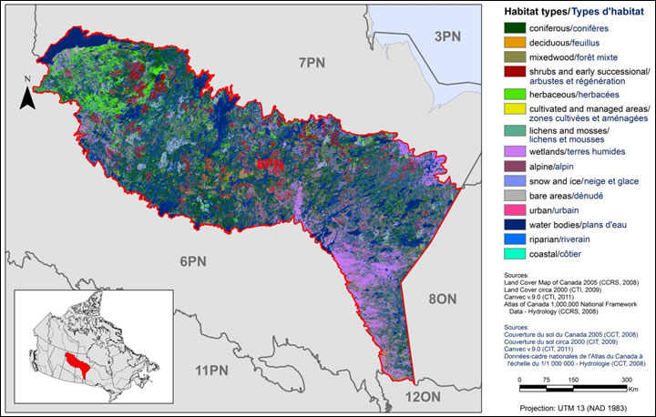
Text Description for Figure 1
Map of the landcover in BCR 8 Prairie and Northern Region: Boreal Softwood Shield. The map's extent includes most of Manitoba and Saskatchewan, as well as part of eastern Alberta; the borders of adjoining BCRs are delineated.
BCR 8 PNR stretches across central Manitoba from the Ontario border, along the eastern shore of Lake Winnipeg, and north to Reindeer Lake. It also includes a large swath of northern Saskatchewan, and extends slightly into Alberta south of Lake Athabasca.
The various habitat types in the BCR are shown on the map and are explained in a bilingual legend, along with sources of information, scale and projection for the map. For BCR 8 PNR, the most common habitat types are coniferous forests, waterbodies, wetlands and herbaceous areas.
Figure 2. Map of protected and designated areas in BCR 8 PNR.
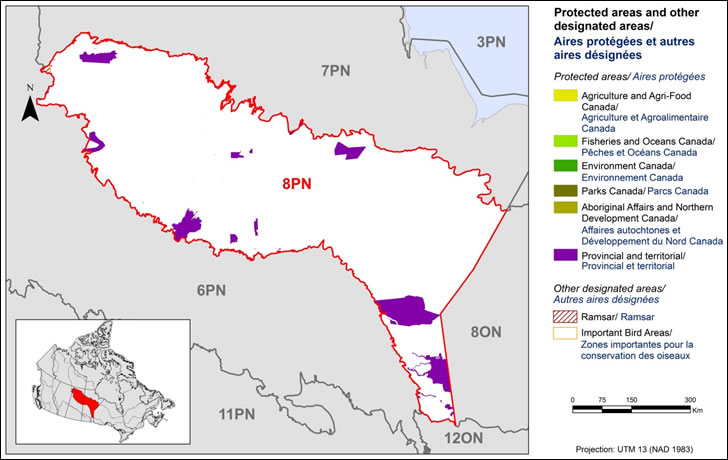
Text Description for Figure 2
Map of protected and other designated areas in BCR 8 Prairie and Northern Region: Boreal Softwood Shield. The map's extent includes most of Manitoba and Saskatchewan, as well as part of eastern Alberta; the borders of adjoining BCRs are delineated.
BCR 8 PNR stretches across central Manitoba from the Ontario border, along the eastern shore of Lake Winnipeg, and north to Reindeer Lake. It also includes a large swath of northern Saskatchewan, and extends slightly into Alberta south of Lake Athabasca.
The various types of protected areas that exist in the BCR are shown on the map, and are explained in the bilingual legend, along with the scale and projection of the map. The most common type of protected area shown is provincial. There is also an Important Bird Areas visible in the northwest corner of the BCR.
- Coniferous/conifères
- Deciduous/feuillus
- Mixedwood/forêt mixte
- Shrubs and early successional/arbustes et régénération
- Cultivated and managed areas/zones cultivées et aménagées
- Wetlands/terres humides
- Bare areas/denude
- Urban/urbain
- Water bodies/plans d'eau
The remaining text in the legend provides the data sources for the map (i.e. Land Cover Map of Canada 2005 (CCRS, 2008), the projection of the map (i.e. UTM 16 (NAD 1983)) and there is a visual representation of the scale of the map. For BCR 12 ON, the most common habitat types are deciduous (especially in the eastern section), coniferous and mixed wood (especially in the western section) forests.