
Bird Conservation Strategy for region 11 in the Prairies and Northern Region
- Abridged version -
August 2013

The abridged version of the strategy available here contains a summary of the results, but does not include an analysis of conservation needs by habitat, a discussion of widespread conservation issues, or the identification of research and monitoring needs.
Other formats available for this document:
Table of contents
- Preface
- Acknowledgements
- Bird Conservation Strategy for Bird Conservation Region 11 in the Prairie and Northern Region: Prairie Potholes
- Executive summary
- Introduction: Bird Conservation Strategies
- Section 1: Summary of results - All Birds, All Habitats
- References
List of figures
- Figure 1. Landcover in BCR 11 Prairie and Northern Region: Prairie Potholes.
- Figure 2. Map of protected and designated areas in BCR 11 Prairie and Northern Region:
Prairie Potholes. - Figure 3. Percent of priority species that are associated with each habitat type in BCR 11 PNR.
- Figure 4. Percent of priority species that are associated with each population objective category in BCR 11 PNR.
- Figure 5. Percent of identified threats to priority species within BCR 11 PNR by threat sub-category.
- Figure 6. Percent of all conservation objectives assigned to each conservation objective category in BCR 11 PNR.
- Figure 7. Percent of recommended actions assigned to each sub-category in BCR 11 PNR.
List of tables
- Table 1. Priority species in BCR 11 PNR, population objectives, and the reason for priority status.
- Table 2. Summary of priority species, by bird group, in BCR 11 PNR.
- Table 3. Number of priority species in BCR 11 PNR by reason for priority status.
- Table 4. Relative magnitude of identified threats to priority species within BCR 11 PNR by threat category and broad habitat class.
Preface
Environment and Climate Change Canada led the development of all-bird conservation strategies in each of Canada’s Bird Conservation Regions (BCRs) by drafting new strategies and integrating new and existing strategies into an all-bird framework. These integrated all-bird conservation strategies will serve as a basis for implementing bird conservation across Canada, and will also guide Canadian support for conservation work in other countries important to Canada’s migrant birds. Input to the strategies from Environment and Climate Change Canada’s conservation partners is as essential as their collaboration in implementing their recommendations.
Environment and Climate Change Canada has developed national standards for strategies to ensure consistency of approach across BCRs. Bird Conservation Strategies will provide the context from which specific implementation plans can be developed for each BCR, building on the programs currently in place through Joint Ventures or other partnerships. Landowners including Aboriginal peoples will be consulted prior to implementation.
Conservation objectives and recommended actions from the conservation strategies will be used as the biological basis to develop guidelines and beneficial management practices that support compliance with regulations under the Migratory Birds Convention Act, 1994.
Acknowledgements
Scott Wilson, Sue Michaelsky, Katherine Brewster, Paul Smith, Lisa Mahon and John Conkin were the main authors of this document, which follows templates developed by Alaine Camfield, Judith Kennedy and Elsie Krebs with the help of the BCR planners in each of the Canadian Wildlife Service regions throughout Canada. However, work of this scope cannot be accomplished without the contribution of many other colleagues who provided or validated technical information, commented on earlier draft versions of the strategy, and supported the planning process. We thank the following individuals for providing many helpful comments during the development and preparation of earlier versions of the BCR 11 strategy: Michael Barr, Ron Bazin, Wendy Calvert, Bob Clark, Brenda Dale, Ken de Smet, Jim Devries, Kiel Drake, Dave Duncan, Cynthia Edwards, Mike Gollop, Cheri Gratto-Trevor, Renny Grilz, Karla Guyn, Bob McFarlane, Glen McMaster, Cindy Paszkowski, Dave Prescott, Samantha Song and Troy Wellicome.
Bird Conservation Strategy for Bird Conservation Region 11 in the Prairie and Northern Region: Prairie Potholes
Text Description for the Map
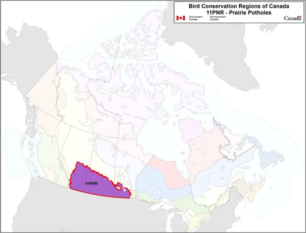
Map of the Bird Conservation Regions (BCRs) of Canada with BCR 11, Prairie and Northern Region: Prairie Potholes highlighted and outlined. Canada (with Alaska, Greenland and the northern portion of the United States of America also appearing) is shown, but it is only present to provide context for the location of the highlighted BCR 11. The Canadian map is divided by BCR (12 Canadian BCRs in total), but their exact locations and sizes are indistinguishable, aside from BCR 11.
The highlighted BCR 11 extends from the foothills of the Rocky Mountains in Alberta, to the Red River Valley in Manitoba, and from the Canadian Border in the south, to the forested habitats of BCR 6 in the North.
The following legend appears in the top right corner of the map: “Bird Conservation Regions of Canada. 11 PNR - Prairie Potholes” and includes the Environment and Climate Change Canada logo, and the Government of Canada logo.
Executive summary
The Prairie Potholes Bird Conservation Region, BCR 11, lies within the Prairie Ecozone at the northern edge of North America’s Great Plains. The Canadian portion of this region (467000 km2) extends from the foothills of the Rocky Mountains in Alberta to the Red River Valley in Manitoba, and from the Canadian border in the south to the forested habitats of BCR 6 in the north. The climate of BCR 11 PNR is generally dry and grasslands are the dominant type of natural habitat, but a moister climate in the northern and eastern extent of the region supports continuous tree cover. Native grasslands are predominantly mixed-grass prairie, but fescue prairie is also found in the west and north, and tallgrass prairie in parts of Manitoba. The Prairie Potholes Bird Conservation Region (BCR) derives its name from the millions of shallow wetlands scattered across the landscape; depressional wetlands from irregular glacial deposits. These natural habitats support many of the region’s birds, but a majority of the landcover has been converted to cropland, rangeland or other agricultural uses; habitats with a reduced value to most birds.
In Canada, BCR 11 is contained within Environment and Climate Change Canada’s Prairie and Northern Region (PNR). This conservation strategy for BCR 11 PNR builds on existing bird conservation plans and complements those created for the other BCRs across Canada. These strategies will serve as a framework for implementing bird conservation nationally, and also identify international conservation issues for Canada’s priority birds. This strategy is not intended to be highly prescriptive, but rather is intended to guide future implementation efforts undertaken by various partners and stakeholders.
We evaluated 341 bird species that occur in the region, and 118 were determined to qualify as priority species (35%). All bird groups were represented, with 36% of the list consisting of landbirds, 25% waterfowl, 21% shorebirds and 19% waterbirds. Among the priority species were 30 assessed as Special Concern or greater by COSEWIC, 26 listed under the federal Species at Risk Act, and 18 listed by provincial species at risk legislation in Alberta, Saskatchewan or Manitoba.
In BCR 11 PNR, the largest number of priority bird species were associated with wetlands (78, or 66%), followed by cultivated and managed areas (72, 61%) and waterbodies (55, 47%). The heavy use of wetlands and waterbodies is to be expected, given that 64% of the priority species list consists of waterfowl, waterbirds and shorebirds. In contrast, the high use of cultivated areas by priority species does not reflect a preference for these habitats per se, but instead is a result of the landscape of BCR 11 PNR being dominated by these agricultural lands. Similarly, the small number of priority species using coniferous, deciduous and mixed forest habitats reflects the small extent of these habitat types in the region.
Population objectives were set on the basis of observed trends. In the Canadian prairies, waterfowl are in general well-monitored but other species less so. For 26 species or populations (22%), survey data were incomplete and a population goal of “Maintain and Assess” was assigned. Among those species for which quantitative objectives could be assigned, populations were below objectives in 33 cases (28%) and at or above objectives in 24 cases (20%). An additional 20 priority species (17%) are species at risk, and objectives are set out in recovery plans. Among all priority species in the region, the most severe population declines have been observed for specialists of grasslands and sagebrush including Burrowing Owl, Sprague’s Pipit, Chestnut-collared Longspur, McCown’s Longspur, Baird’s Sparrow and Greater Sage-Grouse.
BCR 11 PNR is an area heavily affected by agriculture. We identified a large number and diversity of anthropogenic threats and other conservation issues facing priority species in the region, but issues related directly or indirectly to agriculture were most numerous. Conversion of native upland habitats (e.g., shortgrass prairie, sagebrush) to agricultural land, draining of wetlands for agricultural production and other forms of habitat loss remain a concern, but recent conservation efforts have helped to reverse the trend of habitat loss in some areas. Populations of many priority waterfowl and waterbirds are now stable or increasing in BCR 11 PNR due to these efforts.
Other important threats to prairie habitats and the priority birds dependent on them include overgrazing, oil and gas development, invasive species, and a wide variety of other issues. Climate change is expected to result in drier, hotter summers and warmer, wetter winters in the region, but the full extent of the effects on birds are difficult to predict.
These varied threats to priority birds require a correspondingly varied response. Proposed conservation objectives and actions include development and implementation of beneficial management practices to reduce the adverse effects of agriculture on birds, habitat protection and restoration, maintenance of natural processes such as fire and hydrologic cycles, awareness and education campaigns to engage industry and the public in conservation, and a variety of other forms of conservation action.
Management of birds in the BCR also requires targeted investment in monitoring to be better able to assess population status and set population objectives. Similarly, targeted research in the following key areas will clarify both the causes underlying population declines and the most appropriate conservation actions to take:
- Determine primary drivers of population decline and habitat requirements, particularly for grassland- and sagebrush-dependent species
- Map land-cover changes to correlate habitat loss with species declines, identify priority areas and set quantitative habitat objectives
- Conduct research to develop sector-specific beneficial management practices with an emphasis on bird and biodiversity conservation
- Continue research to improve our understanding of the effects of climate change on habitat and species in BCR 11 PNR
These conservation objectives, actions and research needs could all contribute to the conservation of the priority birds of BCR 11 PNR. However, implementation of the recommendations within this strategy will require the cooperation of federal and provincial governments, industry and other stakeholders. Fostering this broad collaboration is the most important next step towards conservation of birds in Canada’s Prairie Pothole region.
Introduction: Bird Conservation Strategies
Context
This document is one of a suite of Bird Conservation Region Strategies (BCR strategies) that have been drafted by Environment and Climate Change Canada for all regions of Canada. These strategies respond to Environment and Climate Change Canada’s need for integrated and clearly articulated bird conservation priorities to support the implementation of Canada’s migratory birds program, both domestically and internationally. This suite of strategies builds on existing conservation plans for the four “bird groups” (waterfowl,Footnote1 waterbirds,Footnote2 shorebirds,Footnote3 and landbirdsFootnote4) in most regions of Canada, as well as on national and continental plans, and includes birds under provincial/territorial jurisdiction. These new strategies also establish standard conservation planning methods across Canada, and fill gaps, as previous regional plans do not cover all areas of Canada or all bird groups.
These strategies present a compendium of required actions based on the general philosophy of achieving scientifically based desired population levels as promoted by the four pillar initiatives of bird conservation. Desired population levels are not necessarily the same as minimum viable or sustainable populations, but represent the state of the habitat/landscape at a time prior to recent dramatic population declines in many species from threats known and unknown. The threats identified in these strategies were compiled using currently available scientific information and expert opinion. The corresponding conservation objectives and actions will contribute to stabilizing populations at desired levels.
The BCR strategies are not highly prescriptive. In most cases, practitioners will need to consult additional information sources at local scales to provide sufficient detail to implement the recommendations of the strategies. Tools such as beneficial management practices will also be helpful in guiding implementation. Partners interested in participating in the implementation of these strategies, such as those involved in the habitat Joint Ventures established under the North American Waterfowl Management Plan (NAWMP), are familiar with the type of detailed implementation planning required to coordinate and undertake on-the-ground activities.
Strategy Structure
Section 1 of this strategy, published here, presents general information about the BCR and the subregion, with an overview of the six elementsFootnote5 that provide a summary of the state of bird conservation at the subregional level. Section 2, included in the full strategy, provides more detail on the threats, objectives and actions for priority species, and the broad habitat types in the subregion. Section 3, also part of the full strategy, presents additional widespread conservation issues that are not specific to a particular habitat or were not captured by the threat assessment for individual species, as well as research and monitoring needs, and threats to migratory birds while they are outside of Canada. The approach and methodology are summarized in the appendices of the full strategy, but details are available in a separate document (Kennedy et al. 2012). A national database houses all the underlying information summarized in this strategy and is available from Environment and Climate Change Canada.
Characteristics of Bird Conservation Region 11
The Prairie Pothole Region (PPR) is the northernmost portion of North America’s Great Plains. The Canadian portion of this region encompasses an area of 467 000 km2, from the foothills of Alberta’s Rocky Mountains in the west to the Red River Valley in Manitoba in the east (Fig. 1). The PPR in Canada is bound by the boreal forest in the north and stretches south to the Canada-U.S. border. The area is also known as the Prairie Ecozone, in the Ecological Framework of Canada.
BCR 11 is generally characterized by a dry climate that supports temperate grasslands; however, moister climates in the northern and eastern portions sustain continuous tree cover. Native grasslands are largely mixed-grass prairie with fescue prairie in the west and north, and tallgrass prairie limited to parts of Manitoba. It is the millions of shallow wetlands, however, that have defined the pothole region. Depressional wetlands stem from irregular glacial deposits and today contribute substantially to the region’s biodiversity (Thorpe and Godwin 2010).
The geomorphologic and climatic characteristics that define the PPR’s suitability for wildlife have made the region particularly attractive for human settlement. As a result of its fertile soils and moderate climate, the region has experienced extensive cultivation, wetland drainage and other forms of habitat modification since the time of European settlement. These historic landscape-level changes have caused widespread loss and degradation of marshlands and native habitats. In particular, the loss of native grassland is unparalleled in other natural habitats of North America. Despite substantial changes to the landscape, the PPR remains among North America’s most important regions for many bird populations. Wetlands of the PPR are renowned for their importance to sustaining populations of waterfowl. Breeding density of dabbling ducks in the PPR may exceed 40 pairs per square kilometre in some areas during years with favourable wetland conditions, and the region comprises the core of the breeding range of most dabbling duck and several diving duck species. The PPR also provides key breeding and staging habitat for over 200 species of waterbirds, shorebirds and landbirds including priority species such as Piping Plover, Sprague’s Pipit, Chestnut-collared Longspur, Baird’s Sparrow, Yellow Rail, Franklin’s Gull, Wilson’s Phalarope, Marbled Godwit and American Avocet (North American Bird Conservation Initiative, U.S. Committee, 2010).
Continued wetland degradation and fragmentation of remaining grasslands and other native habitats threaten future suitability of the PPR for all of these birds; however, other contemporary threats also exist. Environmental pollution, predominantly from agricultural and industrial sources, competition and predation from both native and introduced species, energy development and collisions with human-made structures all threaten high proportions of priority species in BCR 11 PNR. A number of protected areas have been established in BCR 11 PNR aimed at conserving threatened species and their habitats (Fig. 2).
Figure 1. Landcover in BCR 11 Prairie and Northern Region: Prairie Potholes.
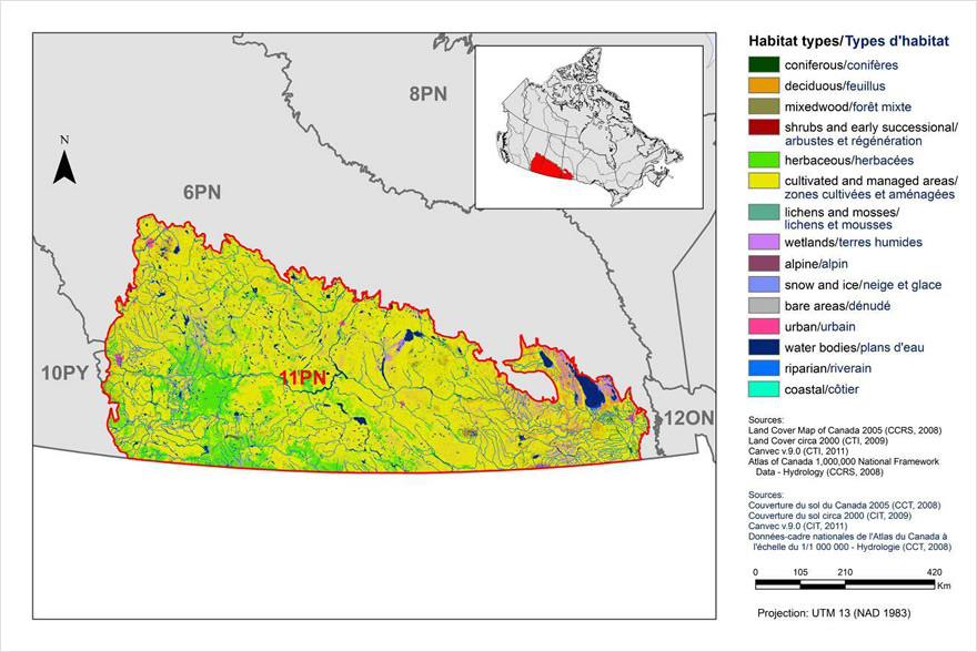
Text Description for Figure 1
Map of the landcover in BCR 11 Prairie and Northern Region: Prairie Potholes. The map's extent includes southern Alberta, Saskatchewan and Manitoba. The borders of BCR 10PY, 6PN, 8PN and 12ON are delineated. BCR 11 has a thick line indicating its borders. Inset in the lower left corner is a map of Canada with BCR 11 highlighted.
BCR 11 extends from the foothills of the Rocky Mountains in Alberta, to the Red River Valley in Manitoba, and from the Canadian Border in the south, to the forested habitats of BCR 6 in the North.
The various habitat types that exist in the BCR are shown on the map, and are explained in the following bilingual legend (appearing to the right of the map):
- Coniferous/conifères
- Deciduous/feuillus
- Mixedwood/forêt mixte
- Shrubs and early successional/arbustes et régénération
- Herbaceous/herbacées
- Cultivated and managed areas/zone cultivées et aménagées
- Lichens and mosses/lichens et mousses
- Wetlands/terres humides
- Alpine/alpin
- Snow and ice/neige et glace
- Bare areas/denude
- Urban/urbain
- Water bodies /plans d’eau
- Riparian/riverain
- Coastal/côtier
The remaining text in the legend provides the data sources for the map (i.e. Land Cover Map of Canada 2005 (CCRS, 2008), the projection of the map (i.e. UTM 9 (NAD 1983)) and there is a visual representation of the scale of the map.
The most common habitat type visible at this scale in BCR 11 is cultivated and managed areas, followed by a moderate amount of herbaceous habitat (mostly in the south west) and deciduous forest (mostly in the south east). Small areas of urban habitat and waterbodies are patchily distributed throughout. The other habitat types are not obvious at this scale, and coastal areas are absent.
Figure 2. Map of protected and designated areas in BCR 11 Prairie and Northern Region: Prairie Potholes.
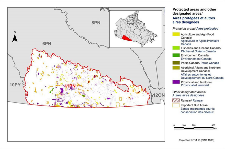
Text Description for Figure 2
Map of protected areas in BCR 11 Prairie and Northern Region: Prairie Potholes. The map's extent includes The map's extent includes southern Alberta, Saskatchewan and Manitoba. The borders of BCR 10PY, 6PN, 8PN and 12ON are delineated. BCR 11 appears in colour (with a thick red line indicating its borders) while the others appear in grey. Inset in the lower left corner is a map of Canada with BCR 11 highlighted.
BCR 11 extends from the foothills of the Rocky Mountains in Alberta, to the Red River Valley in Manitoba, and from the Canadian Border in the south, to the forested habitats of BCR 6 in the North.
The various types of protected areas that exist in the BCR are shown on the map, and are explained in the following bilingual legend (appearing to the right of the map):
Protected areas/Aires protégées
- Agriculture and Agri-Food Canada/Agriculture et Agroalimentaire Canada
- Fisheries and Oceans Canada/Pêches et Océans Canada
- Environment and Climate Change Canada/Environnement et Changement climatique Canada
- Parks Canada/Parcs Canada
- Aboriginal Affairs and Northern Development Canada/Affaires autochtones et Développement du Nord Canada
- Provincial/Provincial
Other designated areas/autres aires désignées
- Important Bird Areas/ Aires d'importance pour les oiseaux
- Ramsar/Ramsar
There is also a visual representation of scale for the map in the legend and the projection of the map (i.e. UTM 9 (NAD 1983)).
The most common type of protected area shown are provincial and Agriculture Canada areas, appearing as a patchwork of small areas throughout the whole BCR. There are approximately an equal amount of important bird areas, also patchily distributed. The other protected areas occur rarely.
Section 1: Summary of results - All Birds, All Habitats
Element 1: Priority species assessment
These Bird Conservation Strategies identify “priority species” from all regularly occurring bird species in each BCR subregion. Species that are vulnerable due to population size, distribution, population trend, abundance and threats are included because of their “conservation concern.” Some widely distributed and abundant “stewardship” species are also included. Stewardship species are included because they typify the national or regional avifauna and/or because they have a large proportion of their range and/or continental population in the subregion; many of these species have some conservation concern, while others may not require specific conservation effort at this time. Species of management concern are also included as priority species when they are at (or above) their desired population objectives but require ongoing management because of their socio-economic importance as game species or because of their impacts on other species or habitats.
The purpose of the prioritization exercise is to focus implementation efforts on the issues of greatest significance for Canadian avifauna. Table 1 provides a full list of all priority species and their reason for inclusion. Tables 2 and 3 summarize the number of priority species in BCR 11 PNR by bird group and by the reason for priority status. We evaluated 341 bird species that occur in the region, and 118 were determined to qualify as priority species (35%; Table 2). All bird groups were represented, with 36% of the list consisting of landbirds, 25% waterfowl, 21% shorebirds and 19% waterbirds. Among the priority species were 28 recognized as Special Concern or greater by COSEWIC, 25 listed under the federal Species at Risk Act, and 18 listed by provincial species at risk legislation in Alberta, Saskatchewan or Manitoba (Table 3).
Table 1. Priority species in BCR 11 PNR, population objectives, and the reason for priority status.
Accessible version of Table 1
| Bird Group | Total Species | Priority Species | Percent Listed as Priority | Percent of Priority List |
|---|---|---|---|---|
| Landbirds | 217 | 42 | 19% | 36% |
| Shorebirds | 39 | 25 | 64% | 21% |
| Waterbirds | 36 | 22 | 61% | 19% |
| Waterfowl | 49 | 29 | 59% | 25% |
| All | 341 | 118 | 35% | 100% |
| Reason for Priority Listinga | Landbirds | Shorebirds | Waterbirds | Waterfowl |
|---|---|---|---|---|
| COSEWICb | 20 | 6 | 4 | 0 |
| Federal SARA Listedc | 18 | 5 | 3 | 0 |
| Provincially Listedd | 9 | 4 | 2 | 3 |
| NAWMPe | - | - | - | 26 |
| National/Continental Concern | 13 | 18 | 15 | 15 |
| Regional Concern | 26 | 7 | 0 | 0 |
| National/Continental Stewardship | 7 | - | - | - |
| Regional Stewardship | 14 | 7 | - | - |
a A single species can be on the priority list for more than one reason. Note that not all reasons for inclusion apply to every bird group (indicated by “-”).
b COSEWIC indicates species assessed by the Committee on the Status of Endangered Wildlife in Canada as Extirpated, Endangered, Threatened or Special Concern.
c Species listed on Schedule 1 of the Species at Risk Act as Extirpated, Endangered, Threatened or Special Concern. Designations current to January 2013.
d Provincially Listedindicates species listed under species at risk legislation of Alberta, Saskatchewan or Manitoba as Extirpated, Endangered, Threatened, Vulnerable or Special Concern.
e NAWMP indicates species ranked in the North American Waterfowl Management Plan (Plan Committee 2004) as having Highest, High or Moderately High breeding or non-breeding conservation and/or monitoring need in the BCR.
Element 2: Habitats Important to Priority Species
Identifying the broad habitat requirements for each priority species within the BCR allowed species to be grouped by shared habitat-based conservation issues and actions. If many priority species associated with the same habitat face similar conservation issues, then conservation action in that habitat may support populations of several priority species. BCR strategies use a modified version of the standard land cover classes developed by the United Nations (Food and Agriculture Organization 2000) to categorize habitats, and species were often assigned to more than one habitat class.
In BCR 11 PNR, the largest number of priority species were associated with wetlands (78, or 66%; Fig. 3), followed by cultivated and managed areas (72, or 61%) and waterbodies (55 or 47%). The heavy use of wetlands and waterbodies is to be expected, given that 64% of the priority species list consists of waterfowl, waterbirds and shorebirds. In contrast, the high use of cultivated areas by priority species does not reflect a preference for these habitats per se, but instead is a result of the landscape of BCR 11 being dominated by these agricultural lands. Similarly, the small number of priority species using coniferous, deciduous and mixed forest habitats reflects the small extent of these habitat types in the region.
Figure 3. Percent of priority species that are associated with each habitat type in BCR 11 PNR.
Note: The total exceeds 100% because each species may be assigned to more than one habitat.
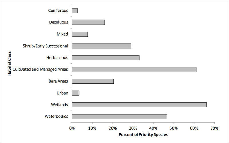
Text Description for Figure 3
| Habitat class | Percent of Priority Species |
|---|---|
| Coniferous | 3% |
| Deciduous | 16% |
| Mixed | 8% |
| Shrub/Early Successional | 29% |
| Herbaceous | 33% |
| Cultivated and Managed Areas | 61% |
| Bare Areas | 20% |
| Urban (Artificial Surfaces and Bare Areas) | 3% |
| Wetlands | 66% |
| Waterbodies, Snow and Ice | 47% |
Note: The total exceeds 100% because each species may be assigned to more than one habitat.
Element 3: Population Objectives
Population objectives allow us to measure and evaluate conservation success. The objectives in this strategy are assigned to categories and are based on a quantitative or qualitative assessment of species’ population trends. If the population trend of a species is unknown, the objective is set as “assess and maintain,” and a monitoring objective is given. For any species listed under the Species at Risk Act (SARA) or under provincial/territorial endangered species legislation, Bird Conservation Strategies defer to population objectives in available Recovery Strategies and Management Plans. The ultimate measure of conservation success will be the extent to which population objectives have been reached over the next 40 years. Population objectives do not currently factor in feasibility of achievement, but are held as a standard against which to measure progress.
The population objectives for priority species in BCR 11 PNR are summarized in Figure 4. Waterfowl of the prairies are surveyed by the large-scale, international “Waterfowl Breeding Population and Habitat Surveys,” among other surveys. In comparison with other species in Canada, prairie waterfowl are in general well monitored. However, many other species are poorly surveyed at present. Excluding migrating shorebirds whose population objectives are set in the BCR 3 PNR strategy, an estimated 38% of the non-waterfowl species are not adequately surveyed in a manner that allows us to assess population trends. This is most notable among waterbirds, where only 8 of 22 priority species are adequately monitored at the BCR and continental levels. Many landbirds are surveyed to some extent by the Breeding Bird Survey; we considered results of this survey to be unreliable if a 3%/year change in population size could not be determined over the long term. Among those species and populations that are reliably surveyed (or still show a trend despite low statistical power), 54 of 68 have declined and objectives seek to restore populations to a former abundance. For 19 species at risk, quantitative population goals are available published in recovery plans. Many of these listed species occur in grasslands, mixed-shrub grasslands or sagebrush habitats. Section 2 in the full version of the strategy reviews the threats facing these species, the ongoing conservation efforts to protect populations and the conservation actions that may be needed to reverse the declines.
Figure 4. Percent of priority species that are associated with each population objective category in BCR 11 PNR.
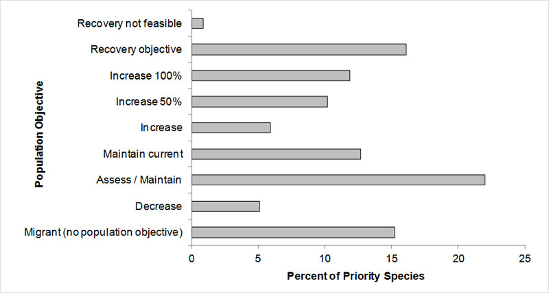
Text Description for Figure 4
| Population Objective | Percent of Priority Species |
|---|---|
| Recovery not feasible | 0.847458 |
| Recovery objective | 16.10169 |
| Increase 100% | 11.86441 |
| Increase 50% | 10.16949 |
| Increase | 5.932203 |
| Maintain current | 12.71186 |
| Assess / Maintain | 22.0339 |
| Decrease | 5.084746 |
| Migrant (no population objective) | 15.25424 |
Element 4: Threat Assessment for Priority Species
The threats assessment process identifies threats believed to have a population-level effect on individual priority species. These threats are assigned a relative magnitude (Low, Medium, High, Very High), based on their scope (the proportion of the species’ range within the subregion that is impacted) and severity (the relative impact on the priority species’ population). This allows us to target conservation actions towards threats with the greatest effects on suites of species or in broad habitat classes. Some well-known conservation issues (such as predation by domestic cats or climate change) may not be identified in the literature as significant threats to populations of an individual priority species and therefore may not be captured in the threat assessment. However, they merit attention in conservation strategies because of the large numbers of individual birds affected in many regions of Canada. We have incorporated them in a separate section on Widespread Issues in the full version of the strategy, but, unlike other threats, they are not ranked.
BCR 11 PNR is an area heavily dominated by agriculture and, perhaps unsurprisingly, issues related to agriculture such as habitat loss, degradation, disturbance and pollution from agricultural effluents were among the most significant threats to priority birds (Fig. 5, Table 4). Disturbance of habitat or breeding birds, habitat loss from human development and water management also emerged as significant threats. A wide variety of anthropogenic and climate-related impacts affected priority species to varying degrees (Fig. 5). Cumulative effects of these myriad threats may be substantial; a discussion of the population-level impacts and the conservation actions needed to counteract these threats appear in subsequent sections of the strategy. Threats to priority species while they are outside Canada during the non-breeding season were also assessed and are presented in the Threats Outside Canada section of the full version of the strategy.
Figure 5. Percent of identified threats to priority species within BCR 11 PNR by threat sub-category.
Note: Each bar represents the percent of the total number of threats identified in each threat sub-category in BCR 11 PNR (for example, if 100 threats were identified in total for all priority species in BCR 11 PNR, and 10 of those threats were in the category 1.1 Housing and urban areas, the bar on the graph would represent this as 10%). Shading in the bars represents the rolled up magnitude of all threats in each threat sub-category in the BCR.
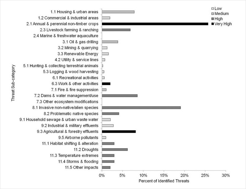
Text Description for Figure 5
| Threat | Overall | % | Low | Medium | High | Very High |
|---|---|---|---|---|---|---|
| 1.1 Housing and urban areas | M | 8% | 8% | |||
| 1.2 Commercial and industrial areas | L | 2% | 2% | |||
| 2.1 Annual and perennial non-timber crops | VH | 26% | 26% | |||
| 2.3 Livestock farming and ranching | H | 7% | 7% | |||
| 2.4 Marine and freshwater aquaculture | 0% | |||||
| 3.1 Oil and gas drilling | M | 4% | 4% | |||
| 3.2 Mining and quarrying | L | 1% | 1% | |||
| 3.3 Renewable Energy | L | 2% | 2% | |||
| 4.2 Utility and service lines | L | 1% | 1% | |||
| 5.1 Hunting and collecting terrestrial animals | L | 0% | 0% | |||
| 5.3 Logging and wood harvesting | L | 1% | 1% | |||
| 6.1 Recreational activities | L | 1% | 1% | |||
| 6.3 Work and other activities | VH | 2% | 2% | |||
| 7.1 Fire and fire suppression | M | 1% | 1% | |||
| 7.2 Dams and water management/use | H | 9% | 9% | |||
| 7.3 Other ecosystem modifications | H | 0% | ||||
| 8.1 Invasive non-native/alien species | H | 19% | 19% | |||
| 8.2 Problematic native species | H | 4% | 4% | |||
| 9.1 Household sewage and urban waste water | L | 2% | 2% | |||
| 9.2 Industrial and military effluents | L | 3% | 3% | |||
| 9.3 Agricultural and forestry effluents | VH | 8% | 8% | |||
| 9.5 Airborne pollutants | L | 1% | 1% | |||
| 11.1 Habitat shifting and alteration | H | 3% | 3% | |||
| 11.2 Droughts | H | 6% | 6% | |||
| 11.3 Temperature extremes | H | 3% | 3% | |||
| 11.4 Storms and flooding | H | 3% | 3% | |||
| 11.5 Other impacts | H | 2% | 2% |
Note: Each bar represents the percent of the total number of threats identified in each sub-threat category in BCR 11 (for example, if 100 threats were identified in total for all priority species in BCR 11, and 10 of those threats were in the category 1.1 Housing and urban areas, the bar on the graph would represent this as 10%). Shading in the bars (VH = very high, H = high, M = medium and L = low) represents the rolled up magnitude of all threats in each threat subcategory in the BCR.
Table 4. Relative magnitude of identified threats to priority species within BCR 11 PNR by threat category and broad habitat class. Accessible version of Table 4
Element 5: Conservation Objectives
Conservation objectives were designed to address threats and information gaps that were identified for priority species. They describe the environmental conditions and research and monitoring that are thought to be necessary for progress towards population objectives and to understand underlying conservation issues for priority bird species. As conservation objectives are reached, they will collectively contribute to achieving population objectives. Whenever possible, conservation objectives were developed to benefit multiple species and/or respond to more than one threat.
In BCR 11 PNR, a majority of threats relate to habitat loss and degradation. Accordingly, the largest proportion of conservation objectives were related to ensuring adequate habitat for priority species (41%; Fig. 6). Direct management of individual species, or direct efforts to reduce mortality or increase productivity, were rare by comparison, accounting for 14% and 9% of recommended actions, respectively (Fig. 6). Because of the potentially far-reaching effects, climate change emerged as a threat of very high magnitude overall (Table 4); conservation objectives directed towards management of the adverse effects of climate change also figure prominently in this strategy.
Figure 6. Percent of all conservation objectives assigned to each conservation objective category in BCR 11 PNR.
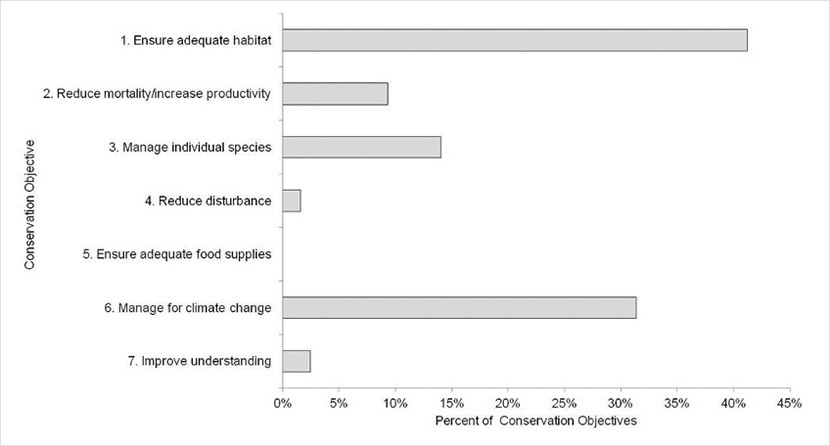
Text Description for Figure 6
| Conservation Objective | % |
|---|---|
| 1 Ensure adequate habitat | 41% |
| 2 Reduce mortality/increase productivity | 9% |
| 3 Manage individual species | 14% |
| 4 Reduce disturbance | 2% |
| 5 Ensure adequate food supplies | 0% |
| 6 Manage for climate change | 31% |
| 7 Improve understanding | 2% |
Element 6: Recommended actions
Recommended actions indicate on-the-ground activities that will help to achieve the conservation objectives (Fig. 7). Actions are strategic rather than highly detailed and prescriptive. Whenever possible, recommended actions benefit multiple species and/or respond to more than one threat. Recommended actions defer to or support those provided in recovery documents for species at risk at the federal, provincial or territorial level but will usually be more general than those developed for individual species.
Conservation in BCR 11 PNR requires the participation of a wide variety of stakeholders. Beneficial management practices, policies and private-sector standards are important tools in the conservation of priority species in the region, as are awareness campaigns and communication with stakeholders and the public (Fig. 7). However, in this heavily human-altered region, protection of remaining natural habitats is also an important conservation need.
Figure 7. Percent of recommended actions assigned to each sub-category in BCR 11 PNR.
Note: “Research” and “monitoring” refer to specific species where additional information is required. For a discussion of broad-scale research and monitoring requirements, see the Research and Population Monitoring Needs section of the full strategy.
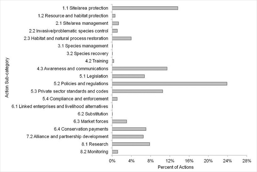
Text Description for Figure 7
| Action Sub-category | % |
|---|---|
| 1.1 Site/area protection | 14% |
| 1.2 Resource and habitat protection | 1% |
| 2.1 Site/area management | 1% |
| 2.2 Invasive/problematic species control | 1% |
| 2.3 Habitat and natural process restoration | 4% |
| 3.1 Species management | 0% |
| 3.2 Species recovery | 0% |
| 4.2 Training | 0% |
| 4.3 Awareness and communications | 11% |
| 5.1 Legislation | 7% |
| 5.2 Policies and regulations | 24% |
| 5.3 Private sector standards and codes | 11% |
| 5.4 Compliance and enforcement | 1% |
| 6.1 Linked enterprises and livelihood alternatives | 0% |
| 6.2 Substitution | 0% |
| 6.3 Market forces | 3% |
| 6.4 Conservation payments | 7% |
| 7.2 Alliance and partnership development | 6% |
| 8.1 Research | 8% |
| 8.2 Monitoring | 1% |
References
Donaldson, G. M., C. Hyslop, R. I. G. Morrison, H. L. Dickson, and I. Davidson (editors). 2000. Canadian Shorebird Conservation Plan. Canadian Wildlife Service, Environment and Climate Change Canada, Ottawa, Ontario. 27pp.
Food and Agriculture Organization (FAO). 2000. Land cover classification system. United Nations Food and Agriculture Organization, Rome.
Kennedy, J.A., E.A. Krebs and A.F. Camfield. 2012. A Manual for Completing All-bird Conservation Plans in Canada, April 2012 version. Canadian Wildlife Service, Environment and Climate Change Canada. Ottawa, ON
Milko, R., L. Dickson, R. Elliot, and G. Donaldson. 2003. Wings Over Water: Canada’s Waterbird Conservation Plan. Canadian Wildlife Service, Environment and Climate Change Canada, Ottawa, Ontario. 28pp.
National Audubon Society. 2010. The Christmas Bird Count Historical Results.
NAWMP Plan Committee. 2004. North American Waterfowl Management Plan 2004. Implementation Framework: Strengthening the Biological Foundation. Canadian Wildlife Service, U.S. Fish and Wildlife Service, pp. 106.
North American Bird Conservation Initiative, U.S. Committee, 2010. The State of the Birds 2010 report on climate change, United States of America. U.S. Department of the Interior: Washington, DC.
Prairie Habitat Joint Venture. 2008. Prairie Habitat Joint Venture Implementation Plan 2007-2012. Report of the Prairie Habitat Joint Venture. Environment and Climate Change Canada, Edmonton, AB. 34pp. (revised May 2009).
Rich, T.D., C.J. Beardmore, H. Berlanga, P.J. Blancher, M.S.W. Bradstreet, G.S. Butcher, D.W. Demarest, E.H. Dunn, W.C. Hunter, E.E. Iñigo-Elias, J.A. Kennedy, A.M. Martell, A.O. Panjabi, D.N. Pashley, K.V. Rosenberg, C.M. Rustay, J.S. Wendt, T.C. Will. 2004. Partners in Flight North American Landbird Conservation Plan. Cornell Lab of Ornithology. Ithaca, NY.
Smith, G.W. 1995. A critical review of the aerial and ground surveys of breeding waterfowl in North America. Biological Science Report 5, National Biological Service, Washington, D.C. 252pp.
Thorpe, J. and B. Godwin. 2010. Prairie EcozonePlus Status and Trends Assessment [Draft #3, March 2010]. Prepared by the Saskatchewan Research Council, Saskatoon, SK.