
Bird Conservation Strategy for region 14 in Quebec
- Abridged version -
October 2013

The abridged version of the strategy available here contains a summary of the results, but does not include an analysis of conservation needs by habitat, a discussion of widespread conservation issues, or the identification of research and monitoring needs.
Other formats available for this document:
Table of contents
- Preface
- Acknowledgements
- Bird Conservation Strategy for Bird Conservation Region 14 in Quebec Region - Atlantic Northern Forest
- Executive summary
- Introduction: Bird Conservation Strategies
- Section 1: Summary of results - All Birds, All Habitats
- References
List of figures
- Figure 1. Landcover in BCR 14-QC: Atlantic Northern Forest.
- Figure 2. Map of protected and designated areas in BCR 14-QC: Atlantic Northern Forest.
- Figure 3.Percent of priority species that are associated with each habitat type in BCR 14-QC.
- Figure 4. Percent of priority species that are associated with each population objective category in BCR 14-QC.
- Figure 5. Percent of identified threats to priority species within BCR 14-QC by threat sub-category.
- Figure 6. Percent of all conservation objectives assigned to each conservation objective category in BCR 14-QC.
- Figure 7. Percent of recommended actions assigned to each sub-category in BCR 14-QC.
List of tables
- Table 1. Priority species in BCR 14-QC, population objective and the reason for priority status.
- Table 2. Summary of priority species, by bird group, in BCR 14-QC.
- Table 3. Number of priority species in BCR 14-QC by reason for priority status.
- Table 4. Relative magnitude of identified threats to priority species within BCR 14-QC by threat category and broad habitat class.
Preface
Environment and Climate Change Canada led the development of all-bird conservation strategies in each of Canada's Bird Conservation Regions (BCRs) by drafting new strategies and integrating new and existing strategies into an all-bird framework. These integrated all-bird conservation strategies will serve as a basis for implementing bird conservation across Canada, and will also guide Canadian support for conservation work in other countries important to Canada's migrant birds. Input to the strategies from Environment and Climate Change Canada's conservation partners is as essential as their collaboration in implementing their recommendations.
Environment and Climate Change Canada has developed national standards for strategies to ensure consistency of approach across BCRs. Bird Conservation Strategies will provide the context from which specific implementation plans can be developed for each BCR, building on the programs currently in place through Joint Ventures or other partnerships. Landowners including Aboriginal peoples will be consulted prior to implementation.
Conservation objectives and recommended actions from the conservation strategies will be used as the biological basis to develop guidelines and beneficial management practices that support compliance with regulations under the Migratory Birds Convention Act, 1994.
Acknowledgements
Véronique Connolly, Stéphane Légaré, Benoît Audet et François Fournier were the main authors of this document which follows templates developed by Alaine Camfield, Judith Kennedy and Elsie Krebs with the help of the BCR planners in each of the Canadian Wildlife Service regions throughout Canada. However, work of this scope cannot be accomplished without the contribution of other colleagues who provided or validated technical information, commented on earlier draft versions of the strategy, and supported the planning process. We would like to thank the following people: Matthieu Allard, Yves Aubry, Luc Bélanger, Martine Benoît, Daniel Bordage, Pierre Brousseau, Vincent Carignan, Richard Cotter, Marie-France Dalcourt, Emmanuel Dalpé-Charron, Bruno Drolet, Gilles Falardeau, Patricia Houle, Benoît Jobin, Sandra Labrecque, Claudie Latendresse, Josée Lefebvre, Christine Lepage, Jean-François Rail and François Shaffer.
Bird Conservation Strategy for Bird Conservation Region 14 in Quebec Region - Atlantic Northern Forest
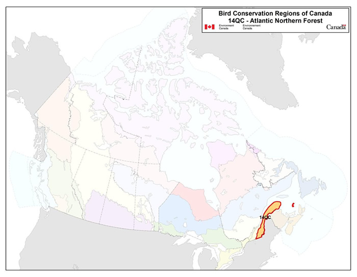
Long description for the Map
Map of the Bird Conservation Regions (BCR's) of Canada with BCR 14 QC highlighted. The extent of the map includes Canada, with Alaska, Greenland and the northern portion of the U.S. also appearing. The map is divided by BCR (12 Canadian BCRs in total), with various colours, and their exact locations and sizes are indistinguishable, aside from BCR 14 QC.
The highlighted BCR 14 QC covers the Gaspé Peninsula, the Magdalene Islands and all but a small portion of south-eastern Quebec.
The following legend appears in the top right corner of the map: “Bird Conservation Regions of Canada. 14 QC - Atlantic Northern Forest” and includes the Environment and Climate Change Canada logo, and the Government of Canada logo.
Executive summary
The Quebec portion of the Atlantic Northern Forest Bird Conservation Region (BCR 14-QC) largely equates to the Appalachian ecoregion and covers 129 186 km2. The region's rugged terrain consists of hills and mountains interspersed with plateaus and large valleys. The terrestrial portion of BCR 14-QC is mainly covered by forests, which are mostly mixed wood and, to a lesser extent, coniferous. Agricultural areas are somewhat prevalent in the southern portion of the region and in the less rugged areas of the rest of the BCR. The marine portion of BCR 14-QC is dominated by the St. Lawrence Estuary and Gulf of St. Lawrence and includes a number of rivers and some large lakes. The coastal habitats in this BCR offer nesting sites for certain waterbird species as well as stopover areas for numerous shorebird species during migration. The BCR 14-QC marine environment also includes islands with steep cliffs where a variety of seabird species nest.
Following an assessment of the 256 bird species in BCR 14-QC, 100 species were identified as priorities in this BCR. The priority list includes species from all 4 bird groups: landbirds (52%), shorebirds (15%), waterbirds (22%) and waterfowl (11%). These priority species include 28 species considered at risk, either provincially or federally. Priority species use 11 habitat types in BCR 14-QC, most frequently coastal areas (37% of priority species), wetlands (34%), mixed wood forests (23%), coniferous forests (22%), deciduous forests (14%) and cultivated and managed areas (14%).
Each priority species was assigned a population objective based on its population trend. Maintaining populations at current levels was the objective assigned to the greatest number of priority species in BCR 14-QC (35%), while 19% were assigned an objective to assess/maintain their populations. Better population trend data are required for the vast majority of the species that have been assigned one of these two objectives. A recovery objective was assigned to 20% of the priority species (all are species at risk), and another 26% of the priority species also require population increases. Overall, 46% of priority species identified in BCR-14 QC were assigned a population increase objective. This reflects the magnitude of the threats affecting bird populations in this BCR.
A threat assessment identified a number of conservation issues facing priority species in the various habitats of BCR 14-QC. Major threats include habitat loss and degradation caused by forestry and agriculture, the presence of native and non-native invasive species, climate change and severe weather. The lack of biological or demographic data on the priority species and the ongoing need for the finalization of recovery strategies and management plans for federally listed species at risk were also considered to be significant conservation issues, as a total of 76% of priority species are affected. The habitats most severely affected by the threats in BCR 14-QC include wetlands, coastal areas, and cultivated and managed areas.
Conservation objectives have been established to counter threats and provide the missing information on priority species. In BCR 14-QC, conservation objectives chiefly involve providing suitable habitat for priority species by ensuring, for example, that resource and land use policies and practices maintain or improve bird habitat. Another major conservation objective is to improve bird population monitoring to gather the missing ecological and demographic information on many of the priority species in the BCR.
Conservation actions have been recommended for priority species in BCR 14-QC in order to achieve the established conservation objectives. The recommended actions largely relate to population monitoring and include on-the-ground activities such as increasing the coverage of the Breeding Bird Survey, conducting species-specific surveys, improving the current migration monitoring program, updating waterfowl banding and survey programs, developing a shorebird monitoring program for the fall migration, and optimizing the seabird monitoring programs. A significant percentage of the recommended actions involve protecting sites and, more particularly, wetlands. These actions include protecting a wide variety of wetlands through stewardship or the legal designation as conservation areas, the adoption of municipal urban plans that protect wetlands, and the protection of shorebird staging areas.
Migratory birds found in BCR 14-QC also face threats that are difficult to analyze with the standardized methodology used in this strategy. These threats include widespread issues that may sometimes not apply to a particular habitat (e.g., collisions with human-made structures, air pollution and climate change), research needs and population monitoring, as well as threats to migratory birds when they are outside Canada. An overview of these issues, the affected species and the recommended conservation actions is also presented.
Introduction: Bird Conservation Strategies
Context
This document is one of a suite of Bird Conservation Region strategies (BCR strategies) that have been drafted by Environment and Climate Change Canada for all regions of Canada. These strategies respond to Environment and Climate Change Canada's need for integrated and clearly articulated bird conservation priorities to support the implementation of Canada's migratory birds program, both domestically and internationally. This suite of strategies builds on existing conservation plans for the four “bird groups” (waterfowl,Footnote1 waterbirds,Footnote2 shorebirdsFootnote3 and landbirdsFootnote4) in most regions of Canada, as well as on national and continental plans, and includes birds under provincial/territorial jurisdiction. These new strategies also establish standard conservation planning methods across Canada and fill gaps, as previous regional plans do not cover all areas of Canada or all bird groups.
These strategies present a compendium of required actions based on the general philosophy of achieving scientifically based desired population levels as promoted by the four pillar initiatives of bird conservation. Desired population levels are not necessarily the same as minimum viable or sustainable populations, but represent the state of the habitat/landscape at a time prior to recent dramatic population declines in many species from threats known and unknown. The threats identified in these strategies were compiled using currently available scientific information and expert opinion. The corresponding conservation objectives and actions will contribute to stabilizing populations at desired levels.
The BCR strategies are not highly prescriptive. In most cases, practitioners will need to consult additional information sources at local scales to provide sufficient detail to implement the recommendations of the strategies. Tools such as beneficial management practices will also be helpful in guiding implementation. Partners interested in participating in the implementation of these strategies, such as those involved in the habitat Joint Ventures established under the North American Waterfowl Management Plan (NAWMP), are familiar with the type of detailed implementation planning required to coordinate and undertake on-the-ground activities.
Strategy structure
Section 1 of this strategy, published here, presents general information about the BCR and the subregion, with an overview of the six elementsFootnote5 that provide a summary of the state of bird conservation at the sub-regional level. Section 2, included in the full version of this strategy, provides more detail on the threats, objectives and actions for priority species grouped by each of the broad habitat types in the subregion. Section 3, also included in the full strategy, presents additional widespread conservation issues that are not specific to a particular habitat or were not captured by the threat assessment for individual species, as well as research and monitoring needs, and threats to migratory birds while they are outside of Canada. The approach and methodology are summarized in the appendices of the full strategy, but details are available in a separate document (Kennedy et al. 2012). A national database houses all the underlying information summarized in this strategy and is available from Environment and Climate Change Canada.
Characteristics of Bird Conservation Region 14-QC
The Atlantic Northern Forest Bird Conservation Region (BCR 14) is bordered by the Adirondack region of New York State to the southwest, includes New England, and covers part of eastern Quebec and all of New Brunswick, Prince Edward Island and Nova Scotia. The Quebec portion of BCR 14 (BCR 14-QC) equates largely to the Appalachian ecoregion (Ecological Stratification Working Group 1996) and occupies a strip south of the St. Lawrence that covers 129 186 km2 from the Gaspé Peninsula to the American border, just east of Lake Champlain (Fig. 1). BCR 14-QC includes most of the upper estuary of the St. Lawrence River, the southern portion of the lower St. Lawrence estuary and part of the Gulf of St. Lawrence, as well as the Magdalen Islands.
Physical environment
Topography
BCR 14-QC's rugged terrain consists of hills and mountains interspersed with plateaus and large valleys (Li and Ducruc 1999). Elevations in this region range from sea level to just over 1 200 m. The highest peaks include Mount Megantic (1 105 m), Mount Albert (1 181 m), Mount Gosford (1 192 m) and Mount Jacques-Cartier (1 268 m; Natural Resources Canada 2013), which is the highest in southern Quebec.
Hydrography and hydrology
The St. Lawrence Estuary and Gulf of St. Lawrence, as well as the Saint-François, Chaudière and Matapédia rivers, make up BCR 14-QC's main water system. Other major rivers include the Etchemin, Kamouraska, Rimouski and Bonaventure. BCR 14-QC contains few lakes, but some are relatively large, such as the Memphremagog (95.3 km2), Saint-François (47. 1 km2), Aylmer (31.1 km2), Temiscouata (66.8 km2) and Matapedia (38 km2) lakes (Quebec's Ministère du Développement durable, de l'Environnement et des Parcs 2002).
Climate
BCR 14-QC's climate varies with latitude and altitude, ranging from moderate in the southwest to harsh in the higher elevations of its eastern portion. The average annual temperature is approximately 3.5°C, with a summer average of 14.5°C and a winter average of -8 °C. The average annual rainfall ranges from 900 mm to 1 300 mm. In the Chic-Choc Mountains, home to the highest peaks in the BCR subregion, precipitation can exceed 1 300 mm and temperatures are cooler (Ecological Stratification Working Group 1996).
Figure 1. Landcover in BCR 14-QC: Atlantic Northern Forest.
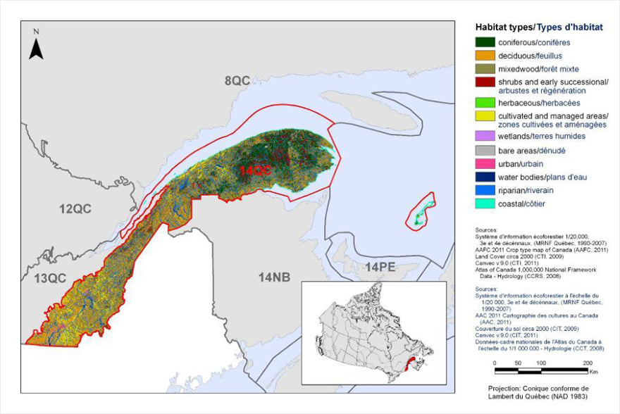
Long description for Figure 1
Map of the landcover in BCR 14 QC. The map's extent includes southeastern Quebec, the Gulf of St Lawrence, the maritime provinces and Maine. The borders of adjoining BCR's are delineated.
BCR 14 QC covers the Gaspé Peninsula, the Magdalene Islands and all but a small portion of south-eastern Quebec.
The various habitat types in the BCR are shown on the map in various colours, which are explained in a bilingual legend, along with sources of information, scale and projection for the map. For BCR 14 QC, the most common habitat types are coniferous forests in the east, and deciduous/mixed forests in the south west.
Map of the landcover in BCR 14 QC. The map's extent includes southeastern Quebec, the Gulf of St Lawrence, the maritime provinces and Maine. The borders of adjoining BCR's are delineated.
BCR 14 QC covers the Gaspé Peninsula, the Magdalene Islands and all but a small portion of south-eastern Quebec.
The various habitat types that exist in the BCR are shown on the map, and are explained in the following bilingual legend (appearing to the right of the map):
- Coniferous/conifères
- Deciduous/feuillus
- Mixedwood/forêt mixte
- Shrubs and early successional/arbustes et régénération
- Herbaceous/herbacées
- Cultivated and managed areas/zone cultivées et aménagées
- Lichens and mosses/lichens et mousses
- Wetlands/terres humides
- Alpine/alpin
- Snow and ice/neige et glace
- Bare areas/denude
- Urban/urbain
- Water bodies /plans d'eau
- Riparian/riverain
- Coastal/côtier
The remaining text in the legend provides the data sources for the map (i.e. Land Cover Map of Canada 2005 (CCRS, 2008), the projection of the map (i.e. UTM 9 (NAD 1983)) and there is a visual representation of the scale of the map.
For BCR 14 QC, the most common habitat types are coniferous forests in the east, and deciduous/mixed forests in the south west.
Land cover and land use
Most of the land in BCR 14-QC is covered by forest, which is predominantly mixed wood (Fig. 1; Li and Ducruc 1999). The BCR's rugged terrain and relatively poor soil have limited agricultural activities to the southern portion of the region, as well as in the lowlands, plateaus and valley floors in the rest of the BCR. Therefore, only approximately 10% of the land in BCR 14-QC consists of cultivated and managed areas. Urban areas account for close to 2% of the land area while wetlands account for only 1%. Nearly all of the land in the southwestern portion of the sub-BCR is privately owned while most of the land in the northeastern portion is publicly owned (Drolet et al. 2010). The main activities in this BCR are forestry, agriculture and tourism (Groupe de travail sur la stratification écologique 1996).
Biological environment
Vegetation
BCR 14-QC contains three subzones of vegetation that transition from the southwestern part of the region to the northeastern part as follows: deciduous forest, mixed wood forest and continuous boreal forest (Quebec's Ministère des Ressources naturelles 2013).
The deciduous forest subzone hosts the sugar maple-basswood bioclimatic domain, which is characterized by diverse flora, including many species at the northern limit of their range. Sugar maple is the dominant species but others such as basswood, American white ash, ironwood and butternut are also found. The deciduous forest subzone also includes the sugar maple-yellow birch bioclimatic domain. The flora here is less diverse but includes several boreal species. Companion species to the sugar maple include the yellow birch, American beech, red oak and hemlock. Windfall is a key element of the forest dynamics in this subzone.
In the eastern portion of BCR 14-QC, the mixed wood forest subzone consists of the balsam fir-yellow birch domain, which is a transition area between the deciduous and boreal forest. This domain is characterized by mixed stands of yellow birch and conifers such as balsam fir, white spruce and cedar. The main drivers of forest dynamics in this sub-area are outbreaks of spruce budworm and fires.
The continuous boreal forest subzone covers much of the easternmost part of BCR 14-QC and is represented by the balsam fir-white birch bioclimatic domain. This bioclimatic domain is characterized by fir and white spruce mixed with white birch mesic sites, while less favourable sites include black spruce, Jack pine and larch, accompanied by white birch or trembling aspen. The main drivers of forest dynamics in this domain are also outbreaks of spruce budworm and fires.
Wildlife
BCR 14-QC features a wide diversity of animal species. Mammal species that are abundant or representative of the region include the white-tailed deer, moose, black bear, Canada lynx, fisher and raccoon (Li and Ducruc 1999). In the eastern portion of the sub-region, on the Gaspé Peninsula, there is an isolated population of Woodland Caribou (mountain ecotype), a species designated as threatened in Quebec and endangered in Canada (Quebec's Ministère du Développement durable, de l’Environnement, de la Faune et des Parcs 2013; Species at Risk Public Registry 2012). The marine portion of BCR 14-QC is used by marine mammals that are at risk in Canada: the Right Whale and Blue Whale, both endangered species; the Beluga, a species threatened in both Quebec and Canada; and the Fin Whale, a species of special concern. BCR 14-QC contains mammal species that are likely to be designated as threatened or vulnerable in Quebec, such as the Gaspé Shrew, Eastern Pipistrelle and Hoary Bat.
BCR 14-QC has numerous amphibian and reptile species, including the Wood Turtle, Leatherback Turtle and the Spring Salamander, which are species at risk in both Canada and Quebec, as well as the Pickerel Frog and Northern Dusky Salamander, two species likely to be designated as threatened or vulnerable in Quebec.
BCR 14-QC is home to a highly diverse fish fauna. Typical fish species include the Atlantic Salmon, Brook Trout, Atlantic Cod, Atlantic Herring, Deepwater Redfish and Atlantic Mackerel (Li and Ducruc 1999; Fisheries and Oceans Canada 2013). The Channel Darter, Rainbow Smelt and American Shad, three vulnerable species in Quebec, are also present in BCR 14-QC.
BCR 14-QC includes a variety of aquatic and terrestrial habitats that are used by a wide range of breeding migratory birds. Species representative of the deciduous forest include the Ruffed Grouse, Yellow-bellied Sapsucker, Wood Thrush, Veery, American Redstart, Black-throated Blue Warbler and Rose-breasted Grosbeak. The mixed wood forest contains species that are common to deciduous and boreal forests, as well as species that are specially adapted to mixed wood stands, such as the Canada Warbler, Black-throated Green Warbler and Blackburnian Warbler. Species characteristic of the boreal forest include the Spruce Grouse, Black-backed Woodpecker, Boreal Chickadee, Bicknell's Thrush, Cape May Warbler, Blackpoll Warbler and Pine Grosbeak. The agricultural areas are inhabited by farmland species, such as the Bobolink, Eastern Meadowlark, Savannah Sparrow and Vesper Sparrow. Species associated with the wetlands include the Common Loon, American Black Duck, Common Goldeneye, Ring-necked Duck, Green-winged Teal and Common Merganser. The coastal habitats offer nesting sites for species such as the Common Tern and Piping Plover, as well as stopover areas for numerous shorebird species (e.g., the Black-bellied Plover, Semipalmated Plover, Ruddy Turnstone and White-rumped Sandpiper) during migration. BCR 14-QC's marine environment also features a number of islands with steep cliffs that are used for nesting by seabirds, such as the Northern Gannet, Black-legged Kittiwake, Razorbill, Common Murre and Black Guillemot. One of these islands, Île Bonaventure, is home to North America's largest Northern Gannet colony, boasting nearly 50 000 breeding pairs (J.-F. Rail, pers. comm.). During migration and wintering periods, the waters of the St. Lawrence Estuary and Gulf of St. Lawrence within BCR 14-QC are used by a number of waterfowl species, such as the Common Eider, Long-tailed Duck, American Scoter, Surf Scoter, Barrow's Goldeneye (Eastern population) and Red-breasted Merganser. Lastly, BCR 14-QC contains species with highly restricted ranges in Quebec, including the Golden-winged Warbler, Nelson’s Sparrow, American Pipit and the eastern population of Harlequin Duck.
Human environment
Approximately 780 000 people live in BCR 14-QC, accounting for 10% of Quebec's population (adapted from Statistics Canada 2012). The major cities are Sherbrooke (154 601 inhabitants), Rimouski (46 860), Saint-Georges (31 173), Thetford Mines (25 709) and Gaspé (15 163). BCR 14-QC has an Aboriginal population of approximately 2 900 inhabitants spread out over three Mi'kmaq communities in the eastern part of the region: Listuguj, Gesgapegiag and Gespeg (Aboriginal Affairs and Northern Development Canada 2010; Statistics Canada 2010).
Protected and designated areas
Approximately 4% of the land in BCR 14-QC is officially protected (Fig. 2). Seven Quebec national parks (responsibility of Quebec's Ministère du Développement durable, de l'Environnement, de la Faune et des Parcs) and one Canadian national park (operated by Parks Canada) are entirely located within the sub-BCR. These parks, occupying a total area of 1323 km2, are the Quebec national parks Mont-Orford, Mont-Mégantic, Frontenac, Bic, Gaspésie, Miguasha and Île Bonaventure-et-du-Rocher-Percé, and the Forillon National Park of Canada. In addition, the sub-region includes 28% (343 km2) of the Saguenay-St. Lawrence Marine Park (joint responsibility of Parks Canada and Quebec's Ministère du Développement durable, de l'Environnement, de la Faune et des Parcs).
BCR 14-QC includes four of Quebec's eight national wildlife areas (Environment and Climate Change Canada's responsibility; Fig. 2). They are the Îles de l'Estuaire, Pointe de l'Est, Pointe-au-Père and Baie de l'Isle-Verte national wildlife areas (the Baie de l'Isle-Verte National Wildlife Area is part of the Ramsar Baie de l'Isle-Verte site and overlaps with BCR 13). Together, they cover an area of 22 km2. There are also five migratory bird sanctuaries (under Environment and Climate Change Canada's mandate), which cover a total area of 32 km2: the Île aux Basques, Bonaventure Island and Percé Rock, Bird Rocks, Saint-Omer and Trois-Saumons migratory bird sanctuaries. An area of 862 km2 is occupied by no less than 165 waterbird staging areas (responsibility of Quebec's Ministère du Développement durable, de l'Environnement, de la Faune et des Parcs).
Finally, BCR 14-QC includes 41 Important Bird Areas (IBAs) totalling 2417 km2 that are designated as important for birds, but which do not receive legal protection.
Figure 2. Map of protected and designated areas in BCR 14-QC: Atlantic Northern Forest.
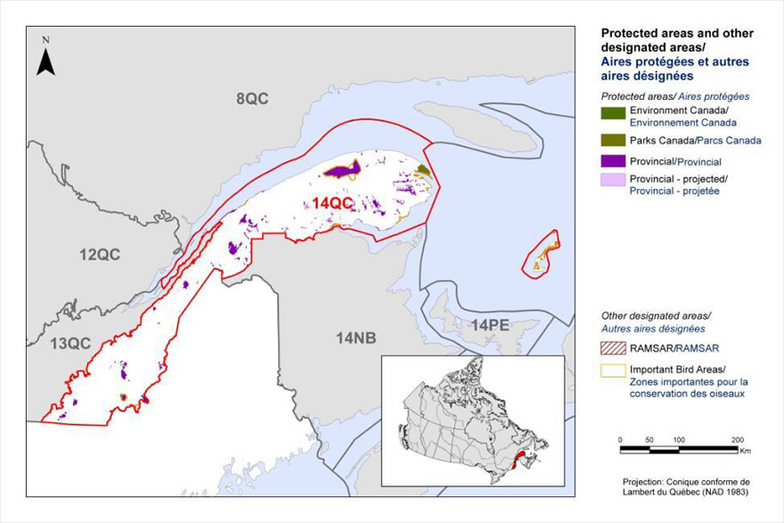
Long description for Figure 2
Map of protected and other designated areas in BCR 14 QC. The map's extent includes southeastern Quebec, the Gulf of St Lawrence, the maritime provinces and Maine. The borders of adjoining BCR's are delineated. BCR 14 QC covers the Gaspé Peninsula, the Magdalene Islands and all but a small portion of south-eastern Quebec.
The various types of protected areas that exist in the BCR are shown on the map, and are explained in the following bilingual legend (appearing to the right of the map):
Protected areas/Aires protégées
- Agriculture and Agri-Food Canada/Agriculture et Agroalimentaire Canada
- Fisheries and Oceans Canada/Pêches et Océans Canada
- Environment and Climate Change Canada/Environnement et Changement climatique Canada
- Parks Canada/Parcs Canada
- Aboriginal Affairs and Northern Development Canada/Affaires autochtones et Développement du Nord Canada
- Provincial/Provincial
Other designated areas/autres aires désignées
- Important Bird Areas/ Aires d'importance pour les oiseaux
- Ramsar/Ramsar
There is also a visual representation of scale for the map in the legend and the projection of the map (i.e. UTM 9 (NAD 1983)).
The most common type of protected area shown is provincial. There is a large Environment and Climate Change Canada protected area at the tip of the peninsula. Several important bird areas are visible, most notably ones in the Magdalene Islands.
Section 1: Summary of results - All Birds, All Habitats
Element 1: Priority species assessment
These Bird Conservation Strategies identify “priority species” from all regularly occurring bird species in each BCR subregion. Species that are vulnerable due to population size, distribution, population trend, abundance and threats are included because of their “conservation concern”. Some widely distributed and abundant “stewardship” species are also included. Stewardship species are included because they typify the national or regional avifauna and/or because they have a large proportion of their range and/or continental population in the subregion; many of these species have some conservation concern, while others may not require specific conservation effort at this time. Species of management concern are also included as priority species when they are at (or above) their desired population objectives but require ongoing management because of their socio-economic importance as game species or because of their impacts on other species or habitats.
The purpose of the prioritization exercise is to focus implementation efforts on the issues of greatest significance for Canadian avifauna. Table 1 provides a full list of all priority species and their reason for inclusion. Tables 2 and 3 summarize the number of priority species in BCR 14-QC by bird group and by the reason for priority status.
The standard method for selecting priority species was used to identify, on a preliminary basis, 94 priority species, sub-species or populations (called “species” hereinafter) from the 256 species occurring in BCR 14-QC). Regional experts reviewed the preliminary list and excluded 16 pre-selected species while adding 22 others, for a final list of 100 priority species (Table 1).
The 100 priority species identified are not distributed equally among the 4 bird groups. Landbirds are the most represented group with 52 species or 52% of all priority species in BCR 14-QC (Table 2). This is an indication of the prevalence of landbirds in the subregion, as they account for 60% of all bird species present. Forty-four percent of shorebird species (15 species) and 69% of waterbird species (22 species) found in the BCR 14-QC have been identified as priority species, an indication of the precarious status of these 2 groups of birds in the sub-BCR. Among the priority species are also 11 waterfowl species (31% of the waterfowl species found in BCR 14-QC [Table 2]).
The vast majority of priority species (71%) were selected because they are of conservation concern (Table 1; shaded cells). They include 28 species at risk, which are listed provincially under the Loi sur les espèces menacées ou vulnerable [Act respecting threatened or vulnerable species] (Quebec), nationally under the Species at Risk Act (SARA), or have received a Committee on the Status of Endangered Wildlife in Canada (COSEWIC) designation. Eighteen species are considered at risk both provincially and nationally, 5 species are considered at risk only by the province of Quebec (Golden Eagle, Nelson’s Sparrow, Leach's Storm-Petrel, Bald Eagle and Sedge Wren), and another 5 species are considered at risk nationally. The latter species are the Bobolink, Wood Thrush, Barn Swallow, Eastern Wood-Pewee and Eastern Meadowlark, which were assessed by COSEWIC but are not currently listed on Schedule 1 of SARA. In addition to the species of conservation concern, 29 species have been identified as priority species for stewardship reasons (Table 1; unshaded cells).
Table 1. Priority species in BCR 14-QC, population objective and the reason for priority status.
Accessible version of Table 1
| Bird Group | Total Species | Total Priority Species | Percent Listed as Priority | Percent of Priority List |
|---|---|---|---|---|
| Landbird | 154 | 52 | 34% | 52% |
| Shorebird | 34 | 15 | 44% | 15% |
| Waterbird | 32 | 22 | 69% | 22% |
| Waterfowl | 36 | 11 | 31% | 11% |
| Total | 256 | 100 | 39% | 100% |
| Reason for Priority Listinga | Landbirds | Shorebirds | Waterbirds | Waterfowl |
|---|---|---|---|---|
| COSEWICb | 15 | 2 | 4 | 2 |
| Federal SARA listedc | 10 | 2 | 4 | 2 |
| Provincially listedd | 14 | 2 | 5 | 2 |
| National/Continental Concerne | 21 | - | - | - |
| Regional Concerne | 11 | - | - | - |
| Continental Stewardshipe | 14 | - | - | - |
| Regional Stewardshipe | 16 | - | - | - |
| Conservation categoryf | - | 13 | - | - |
| Priority levelg | - | 13 | - | |
| NAWMPh | - | - | - | 7 |
| Expert reviewi | 7 | 2 | 9 | 4 |
a A single species can be on the priority list for more than one reason. Note that not all reasons for inclusion apply to every bird group (indicated by “-”).
b COSEWIC indicates species assessed by the Committee on the Status of Endangered Wildlife in Canada as Endangered, Threatened, or Special Concern.
c Species listed on Schedule 1 of SARA as Endangered, Threatened, or Special Concern.
d Provincially Listed indicates species listed under the Loi sur les espèces menacées ou vulnérables (Quebec) as Threatened, Vulnerable, or Likely to be designated threatened or vulnerable.
e See Table 1.
f Conservation category indicates a species ranked in Canada’s Shorebird Conservation Plan (Donaldson et al., 2000) as having a 5, 4a, 4b or 3a conservation category in the United States of America and Canada.
g Priority level indicate a species ranked in Canada’s Waterbird Conservation Plan (Milko et al., 2003) as belonging to Tier 1 or Tier 2.
h NAWMP indicates species ranked in the North American Waterfowl Management Plan (Plan Committee 2004) as having Highest, High or Moderately High breeding or non-breeding conservation and/or monitoring need in the BCR.
i Species that did not meet the standard criteria but that were added by experts.
Element 2: Habitats important to priority species
Identifying the broad habitat requirements for each priority species within the BCR allowed species to be grouped by shared habitat-based conservation issues and actions. If many priority species associated with the same habitat face similar conservation issues, then conservation action in that habitat may support populations of several priority species. BCR strategies use a modified version of the standard land cover classes developed by the United Nations (Food and Agriculture Organization 2000) to categorize habitats, and species were often assigned to more than one habitat class.
Eleven habitat classes are used by priority species in BCR-14 QC (Fig. 3). Coastal areas are the habitat class used by the greatest number of priority species (37). This habitat class is used by most of the priority waterbird, shorebird and waterfowl species found in the subregion.
Although they constitute only 1% of the BCR 14-QC land area, wetlands are the second habitat class most used by priority species (34% of priority species). This habitat class is used by all 4 bird groups, with landbirds dominating (14 species).
Mixed wood forest (23% of priority species), coniferous forest (22%), deciduous forest (14%), and cultivated and managed areas (14%) are among the other habitats most used by priority species. The various forest types are used exclusively by priority terrestrial species, while the cultivated and managed areas are used mostly by landbird species but are also inhabited by priority waterfowl and shorebird species.
See Section 2 of the full strategy for additional details on priority species, threats and conservation actions for each habitat class in BCR 14-QC.
Figure 3. Percent of priority species that are associated with each habitat type in BCR 14-QC.
Note: The total exceeds 100% because each species may be assigned to more than one habitat.
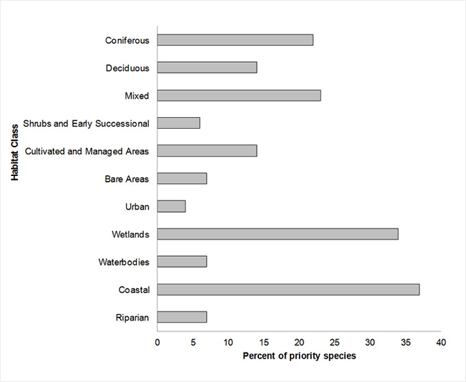
Long description for Figure 3
| Habitat | % |
|---|---|
| Coniferous | 22 |
| Deciduous | 14 |
| Mixed | 23 |
| Shrubs and Early Successional | 6 |
| Cultivated and Managed Areas | 14 |
| Bare Areas | 7 |
| Urban | 4 |
| Wetlands | 34 |
| Waterbodies | 7 |
| Coastal | 37 |
| Riparian | 7 |
Note: The total exceeds 100% because each species may be assigned to more than one habitat.
Element 3: Population objectives
Population objectives allow us to measure and evaluate conservation success. The objectives in this strategy are assigned to categories and are based on a quantitative or qualitative assessment of species' population trends. If the population trend of a species is unknown, the objective is set as “assess and maintain”, and a monitoring objective is given. For any species listed under SARA or under provincial/territorial endangered species legislation, Bird Conservation Strategies defer to population objectives in available Recovery Strategies and Management Plans. The ultimate measure of conservation success will be the extent to which population objectives have been reached over the next 40 years. Population objectives do not currently factor in feasibility of achievement, but are held as a standard against which to measure progress.
Maintaining populations at current levels was the objective assigned to the greatest number of priority species in BCR 14-QC (35% of priority species; Fig. 4). For 33 of the 35 species that have been assigned this objective, better population trend data must be acquired for decision making. This also applies to all but one of the species whose population objective is “Assess/Maintain” (19% of priority species).
As a result of the significant presence of species at risk in BCR 14-QC, recovery population objectives relating to species at risk represents 20% of all objectives for the region. In addition to these recovery objectives, which all seek to increase populations of species at risk, population increase objectives were also assigned to 26% of priority species under the categories “Increase,” “Increase 50%” and “Increase 100%.” Overall, 46% of priority species identified in BCR-14 QC were assigned a population increase objective. This reflects the magnitude of the threats affecting bird populations in this BCR.
Figure 4. Percent of priority species that are associated with each population objective category in BCR 14-QC.
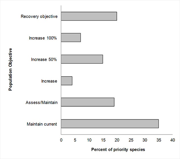
Long description for Figure 4
| Objective | % priority species |
|---|---|
| Recovery objective | 20 |
| Increase 100 % | 7 |
| Increase 50 % | 15 |
| Increase | 4 |
| Assess / Maintain | 19 |
| Maintain current | 35 |
Element 4: Threat assessment for priority species
The threats assessment process identifies threats believed to have a population-level effect on individual priority species. These threats are assigned a relative magnitude (Low, Medium, High, Very High), based on their scope (the proportion of the species' range within the subregion that is impacted) and severity (the relative impact on the priority species' population). This allows us to target conservation actions towards threats with the greatest effects on suites of species or in broad habitat classes. Some well-known conservation issues (such as predation by domestic cats or climate change) may not be identified in the literature as significant threats to populations of an individual priority species and therefore may not be captured in the threat assessment. However, they merit attention in conservation strategies because of the large numbers of individual birds affected in many regions of Canada. We have incorporated them in a separate section of the full strategy called Widespread Issues, but, unlike other threats, they are not ranked.
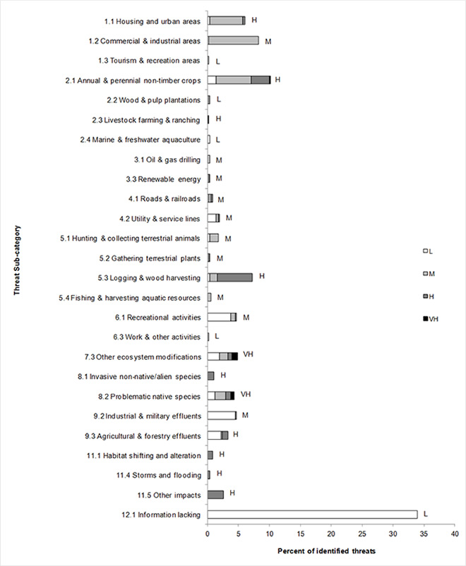
Bird populations found in BCR 14-QC face many threats from different sources. No less than 509 threats classified into 11 categories and 26 sub-categories have been identified and are summarized in Figure 5. Category 12 “Other direct threats,” represented by sub-category “12.1 Information lacking,” is the category most frequently associated with priority species in BRC 14-QC because it includes 34% of all identified threats. This category, with a “Low” overall relative magnitude, consists of elements relating to the lack of biological or demographic information required for appropriate population management. Its magnitude is also attributable to the presence of species at risk for which there are no finalized recovery strategies, management plans or action plans (Table 4). Only 9 of the 28 species at risk in BCR 14-QC had a completed recovery strategy, action plan or management plan when this strategy was written. Overall, the need for more information was identified for 83 of the 100 priority species in BCR 14-Qc.
Category 1”Residential and commercial development” ranks second in the percentage of threats affecting priority species in BCR 14-QC, with just over 14% of all threats. This category of “Medium” overall relative magnitude is represented by sub-categories “1.1 Housing and urban areas” and “1.2 Commercial and industrial areas,” which account for 6% and 8% of identified threats, respectively (Fig. 5). These sub-categories include threats such as habitat loss and/or degradation due to drainage and filling of wetlands for residential, commercial or industrial development, loss of woodlands for development, and a decrease in the abundance of prey insects caused by the destruction of wetlands.
Category “2. Agriculture and aquaculture” has a “High” overall relative magnitude and is mainly represented by sub-category “2.1 Annual and perennial non-timber crops,” which accounts for 10% of all identified threats. This sub-category includes elements such as the conversion of forested farmland to arable land, habitat loss and degradation due to the transition from perennial to annual crops, intensification of agriculture, and drainage and filling of wetlands for agriculture.
Category “5. Biological resource use,” which has a “High” overall relative magnitude, is also a major threat. It is mainly represented by sub-category “5.3 Logging and wood harvesting,” which alone is responsible for 7% of the threats identified in BCR 14-QC, and includes forest habitat fragmentation, loss of mature forest, and the decrease in the number of snags with cavities, stands of dead trees and large-diameter trees.
Category “9. Pollution” includes 8% of identified threats and has a “Medium” overall relative magnitude. This category is represented by sub-categories “9.2 Industrial and military effluents” and “9.3 Agricultural and forestry effluents.” The threats relating to sub-category 9.2 are oil spills and sediment contamination, while the only threat in sub-category 9.3 is the overuse of pesticides, which can cause bird poisoning, eggshell thinning, and a reduction in insect populations and prey fish.
Category “8. Invasive and other problematic species and genes” is represented by sub-categories “8.1 Invasive non-native/alien species” and “8.2 Problematic native species” in BCR 14-QC. Although it describes just over 5% of all existing threats, this category has a “Very High” overall relative magnitude. The only threat in sub-category 8.1 is wetland loss and degradation caused by invasive non-native plants. The threats associated with sub-category 8.2 include nest predation by the Brown-headed Cowbird, predation of waterbird nests by the Red Fox and gulls, and predation of shorebirds in staging areas.
Category “7. Natural system modifications” includes approximately 5% of identified threats, but its overall relative magnitude is “High.” The only sub-category included in this category is “7.3 Other ecosystem modifications,” and it involves the abandonment of agricultural land, which becomes unsuitable for some species of farmland birds; closure or disturbance of pits used for nesting; transition of shrub habitats to forest habitats; and alteration of the Havre-aux-Basques habitat (Magdalen Islands), which could affect numerous shorebird species.
Category “11. Climate change and severe weather” is another category that includes only a small percentage of identified threats (close to 4%) but has a “High” overall relative magnitude. This category includes three sub-categories in BCR 14-QC: “11.1 Habitat shifting and alterations,” “11.4 Storms and flooding” and “11.5 Other impacts.” The only threat in sub-category 11.1 is wetland loss and degradation, while sub-category 11.4 involves more frequent flooding affecting the wetlands and cultivated and managed areas. The threats in sub-category 11.5 mainly relate to the increased frequency of adverse weather events that could affect migration, reproductive success, nesting phenology and prey availability. This threat affects aerial insectivores such as the Common Nighthawk, Barn Swallow, Chimney Swift and Olive-sided Flycatcher.
Each of the “3. Energy production and mining”, “4. Transportation and service corridors” and “6. Human intrusions and disturbance” threat categories includes less than 5% of all identified threats and has a “Medium” overall relative magnitude.
The overall relative magnitude of threats to priority species is “High” in 5 of the 11 habitat classes in BCR 14-QC: shrub/early successional, cultivated and managed areas, urban, wetlands and coastal. Also noted is the “Very High” relative impact of three threat categories on priority species in specific habitats, that is, “2. Agriculture and aquaculture” on cultivated and managed areas, “7. Natural system modifications” on shrub/early successional habitat and “8. Invasive and other problematic species and genes” on wetlands and coastal areas.
Section 2 of the full strategy provides more details on the threats associated with the various habitat classes. Threats to priority species while they are outside Canada during the non-breeding season were also assessed and are presented in the Threats Outside Canada section of the full strategy.
Figure 5. Percent of identified threats to priority species within BCR 14-QC by threat sub-category.
Note: Each bar represents the percent of the total number of threats identified in each threat sub-category in BCR 14-QC (for example, if 100 threats were identified in total for all priority species in BCR 14-QC, and 10 of those threats were in the category 1.1 Housing and urban areas, the bar on the graph would represent this as 10%). Shading in the bars (VH = very high, H = high, M = medium and L = low) represents the rolled-up magnitude of all threats in each threat sub-category in the BCR.
Long description for Figure 5
| Threat subcategory | L | M | H | VH |
|---|---|---|---|---|
| 1.1 Housing and urban areas | 0 | 5 | 0 | 0 |
| 1.2 Commercial and industrial areas | 0 | 8 | 0 | 0 |
| 1.3 Tourism and recreation areas | 0 | 0 | 0 | 0 |
| 2.1 Annual and perennial non-timber crops | 1 | 6 | 3 | 0 |
| 2.2 Wood and pulp plantations | 0 | 0 | 0 | 0 |
| 2.3 Livestock farming and ranching | 0 | 0 | 0 | 0 |
| 2.4 Marine and freshwater aquaculture | 0 | 0 | 0 | 0 |
| 3.1 Oil and gas drilling | 0 | 0 | 0 | 0 |
| 3.3 Renewable energy | 0 | 0 | 0 | 0 |
| 4.1 Roads and railroads | 0 | 0 | 0 | 0 |
| 4.2 Utility and service lines | 1 | 0 | 0 | 0 |
| 5.1 Hunting and collecting terrestrial animals | 0 | 1 | 0 | 0 |
| 5.2 Gathering terrestrial plants | 0 | 0 | 0 | 0 |
| 5.3 Logging and wood harvesting | 0 | 1 | 6 | 0 |
| 5.4 Fishing and harvesting aquatic resources | 0 | 1 | 0 | 0 |
| 6.1 Recreational activities | 4 | 1 | 0 | 0 |
| 6.3 Work and other activities | 0 | 0 | 0 | 0 |
| 7.3 Other ecosystem modifications | 2 | 1 | 1 | 1 |
| 8.1 Invasive non-native/alien species | 0 | 0 | 1 | 0 |
| 8.2 Problematic native species | 1 | 2 | 1 | 1 |
| 9.2 Industrial and military effluents | 5 | 0 | 0 | 0 |
| 9.3 Agricultural and forestry effluents | 2 | 0 | 1 | 0 |
| 11.1 Habitat shifting and alteration | 0 | 0 | 1 | 0 |
| 11.4 Storms and flooding | 0 | 0 | 0 | 0 |
| 11.5 Other impacts | 0 | 0 | 3 | 0 |
| 12.1 Information lacking | 34 | 0 | 0 | 0 |
Note: Each bar represents the percent of the total number of threats identified in each sub-threat category in BCR 14 QC (for example, if 100 threats were identified in total for all priority species in BCR 14 QC, and 10 of those threats were in the category 1.1 Housing and urban areas, the bar on the graph would represent this as 10%). Shading in the bars (VH = Very High, H = high, M = medium and L = low) represents the rolled up magnitude of all threats in each threat subcategory in the BCR.
Table 4. Relative magnitude of identified threats to priority species within BCR 14-QC by threat category and broad habitat class. Accessible version of Table 4
Element 5: Conservation objectives
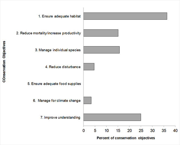
Conservation objectives were designed to address threats and information gaps that were identified for priority species. They describe the environmental conditions and research and monitoring that are thought to be necessary for progress towards population objectives and to understand underlying conservation issues for priority bird species. As conservation objectives are reached, they will collectively contribute to achieving population objectives. Whenever possible, conservation objectives were developed to benefit multiple species and/or respond to more than one threat.
Conservation objectives have been divided into the seven categories presented in Figure 6. In BCR-14 QC, 36% of suggested conservation objectives are in category “1. Ensure adequate habitat” and involve nearly all the habitats in BCR 14-QC, with the exception of waterbodies. This objective category includes three sub-categories affecting BCR 14-QC: “1.1 Ensure land and resource-use policies and practices maintain or improve bird habitat,” “1.2 Maintain the size, shape and configuration of habitat within the natural range of variation” and “1.4 Maintain important bird features on the landscape.”
Objective “7. Improve understanding (of population status, limiting factors and mitigation)” ranks second with 25% of all suggested conservation objectives. The vast majority of objectives in this category are from sub-category “7.1 Improve population/demographic monitoring,” while the other objectives are associated with sub-category “7.4 Improve understanding of causes of population declines.” This indicates a need for increased monitoring in the BCR for numerous priority species in the four bird groups.
Sixteen percent of the objectives involve managing individual species (category 3). Close to 90% of this category's objectives are from sub-category “3.4 Implement recovery plans for species at risk”, as there are 28 species at risk in BCR 14-QC. Sub-categories “3.3 Reduce parasitism/predation” and “3.5 Prevent and control the spread of invasive and exotic species” complete this category's objectives.
Objective “2. Reduce mortality/increase productivity” represents 15% of the conservation objectives in BCR 14-QC. Nearly half of this category's objectives are in sub-category “2.1 Reduce mortality and/or sub-lethal effects from pesticide use,” while slightly over 20% are from sub-category “2.7. Reduce incidental mortality from collisions.” The other objectives in this category are part of sub-categories “2.2. Reduce mortality and/or sub-lethal effects from exposure to contaminants,” “2.4 Reduce incidental mortality” and “2.8. Reduce mortality from legal or illegal hunting, and persecution.”
Categories “4. Reduce disturbance” and “6. Manage for climate change” account for 5% and 3% of all the objectives raised for BCR 14-QC, respectively. Sub-category “4.1 Reduce disturbance from human recreation,” which primarily involves birds in wetlands and coastal areas, is the only sub-category included in category 4. All category 6 objectives are from sub-category “6.2 Manage for habitat resilience as climate changes” and are mainly associated with aerial insectivores and certain waterbirds. No objectives have been assigned to sub-category “5. Ensure adequate food supplies” in BCR 14-QC.
Figure 6. Percent of all conservation objectives assigned to each conservation objective category in BCR 14-QC.
Note: Objective “7. Improve understanding” means improving our understanding of population status, limiting factors and mitigation.
Long description for Figure 6
| Objective | Percent |
|---|---|
| 1. Ensure adequate habitat | 36.39705882 |
| 2. Reduce mortality/increase productivity | 15.07352941 |
| 3. Manage individual species | 15.625 |
| 4. Reduce disturbance | 4.595588235 |
| 5. Ensure adequate food supplies | 0 |
| 6. Manage for climate change | 3.308823529 |
| 7. Improve understanding | 25 |
Element 6: Recommended actions
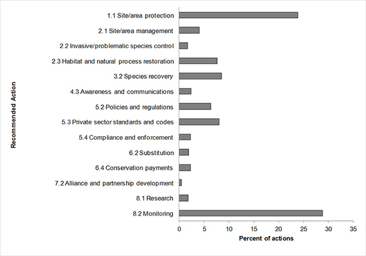
Recommended actions indicate on-the-ground activities that will help to achieve the conservation objectives (Fig. 7). Actions are strategic rather than highly detailed and prescriptive. Whenever possible, recommended actions benefit multiple species and/or respond to more than one threat. Recommended actions defer to or support those provided in recovery documents for species at risk at the federal, provincial or territorial level, but will usually be more general than those developed for individual species.
Figure 7 shows that close to 29% of the actions recommended in BCR 14-QC are in sub-category “8.2 Monitoring.” The high frequency of this recommendation is primarily due to the lack of biological or demographic information on the priority species in the BCR. The actions suggested in this category include increasing the coverage of the Breeding Bird Survey, conducting specific surveys (e.g., surveys of high-altitude birds, breeding birds in boreal forests or nocturnal birds), improving the current migration monitoring program, updating waterfowl banding and survey programs, developing a shorebird monitoring program for the fall migration and optimizing seabirds monitoring. For more information, see the Research and Population Monitoring Needs section of the full strategy.
Sub-category “1.1 Site/area protection” is the second largest, with nearly 24% of all recommended actions. The actions recommended in this category mainly target wetlands and include protecting a variety of wetlands through stewardship or the legal designation of wetlands as conservation areas, the adoption of municipal urban plans that protect wetlands and the protection of shorebird staging areas. These actions are specifically aimed at minimizing the impact of the threats relating to residential and commercial development, as well as agriculture.
Sub-category “3.2 Species recovery” is the third most-frequently mentioned action sub-category (8%) and mainly involves continuing to develop and implement species at risk recovery documents and associated activities.
The adoption of standards and beneficial practices (5.3), mainly in agriculture and forestry, represents 8% of recommended actions. More specifically, developing sustainable agriculture, implementing silvicultural treatments that maintain key habitat features and the landscape structure, and establishing beneficial management practices are some of the actions suggested for overcoming a number of threats relating to annual and perennial crops, and logging and wood harvesting.
Habitat and natural process restoration (2.3) represents 7% of the recommended actions and primarily concerns coastal areas and wetlands. The actions suggested in this category involve maintaining the efficiency of Environment and Climate Change Canada's emergency response programs, as well as reducing pesticide use by promoting integrated pest management.
Sub-category “5.2 Policies and regulations” includes slightly more than 6% of the recommended actions and refers primarily to improving the protection of wetlands through available policies, regulations and stewardship tools. Each of the other sub-categories represents less than 5% of the recommended actions (Fig. 7).
More details on recommended actions for the various habitat classes are presented in Section 2 of the full strategy.
Figure 7. Percent of recommended actions assigned to each sub-category in BCR 14-QC.
Note: “Research” and “monitoring” refer to specific species where additional information is required. For a discussion of broad-scale research and monitoring requirements, see the Research and Population Monitoring Needs section of the full strategy.
Long description for Figure 7
| Actions | % |
|---|---|
| 1.1 Site/area protection | 24 |
| 2.1 Site/area management | 4 |
| 2.2 Invasive/problematic species control | 2 |
| 2.3 Habitat and natural process restoration | 8 |
| 3.2 Species recovery | 8 |
| 4.3 Awareness and communications | 2 |
| 5.2 Policies and regulations | 6 |
| 5.3 Private sector standards and codes | 8 |
| 5.4 Compliance and enforcement | 2 |
| 6.2 Substitution | 2 |
| 6.4 Conservation payments | 2 |
| 7.2 Alliance and partnership development | 0 |
| 8.1 Research | 2 |
| 8.2 Monitoring | 29 |
References
Aboriginal Affairs and Northern Development Canada. 2010. Aboriginal peoples in Quebec [On line]. (Accessed 11 October 2013)
Aubry, Y. and R. Cotter. 2007. Québec Shorebird Conservation Plan, Environment and Climate Change Canada, Canadian Wildlife Service, Québec region, Sainte-Foy, xvi + 196 p.
Chapdelaine, G. and J.-F. Rail. 2004. Québec’s Waterbird Conservation Plan. Migratory Bird Division, Canadian Wildlife Service, Québec region, Environment and Climate Change Canada, Sainte-Foy, Québec. 99 p.
Donaldson, G. M., C. Hyslop, R. I. G. Morrison, H. L. Dickson, and I. Davidson (editors). 2000. Canadian Shorebird Conservation Plan. Canadian Wildlife Service, Environment and Climate Change Canada, Ottawa, Ontario. 27pp.
Drolet, B., V. Carignan, M.-A. Vaillancourt and G. Falardeau. 2010. Plan de conservation des oiseaux terrestres du Québec : volume 1, oiseaux des milieux forestiers. Unpublished working document, Environment and Climate Change Canada, Canadian Wildlife Service, Québec region.
Ecological Stratification Working Group. 1995. A National Ecological Framework for Canada. Agriculture and Agri-Food Canada, Research Branch, Centre for Land and Biological Resources Research and Environment and Climate Change Canada, State of the Environment Directorate, Ecozone Analysis Branch, Ottawa/Hull. Report and national map at 1:7500 000 scale.
Falardeau, G., V. Carignan, B. Drolet and M.-A. Vaillancourt. 2010. Plan de conservation des oiseaux terrestres du Québec, volume 2 : les oiseaux des milieux agricoles, humides, urbains, arctiques, alpins et des falaises. Unpublished working document, Environment and Climate Change Canada, Canadian Wildlife Service, Québec region.
Fisheries and Oceans Canada. 2013. List of aquatic species living in Canadian waters [On line]. (Accessed 12 September 2013).
Food and Agriculture Organization (FAO). 2000. Land cover classification system. United Nations Food and Agriculture Organization, Rome.
Kennedy, J.A., E.A. Krebs and A.F. Camfield. 2012. A Manual for Completing All-bird Conservation Plans in Canada, April 2012 version. Canadian Wildlife Service, Environment and Climate Change Canada. Ottawa, ON.
Lepage, C., D. Bordage, D. Dauphin, F. Bolduc and B. Audet. In preparation. Plan de conservation de la sauvagine du Québec, 2010. Environment and Climate Change Canada, Canadian Wildlife Service, Quebec region, Quebec.
Li, T. and J.-P. Ducruc. 1999. Les provinces naturelles. Niveau I du cadre écologique de référence du Québec (in French only). Ministère de l’Environnement. [On line] (Accessed 25 August 2012).
Milko, R., L. Dickson, R. Elliot, and G. Donaldson. 2003. Wings Over Water: Canada’s Waterbird Conservation Plan. Canadian Wildlife Service, Environment and Climate Change Canada, Ottawa, Ontario. 28pp.
Ministère des Ressources naturelles. 2013. Zones de végétation et domaines bioclimatiques du Québec (in French only) [On line].(Accessed 28 February 2013).
Ministère du Développement durable, de l’Environnement, de la Faune et des Parcs. 2013. Liste des espèces désignées menacées ou vulnérables au Québec (in French only) [On line]. (Accessed 4 April 2013).
Ministère du Développement durable, de l’environnement et des Parcs. 2002. Portrait général de l’eau (in French only) [On line].(Accessed 7 August 2012).
Natural Resources Canada. 2013. The Atlas of Canada. [On line]. (Accessed 12 September 2013).
North American Waterfowl Management Plan, Plan Committee. 2004. North American Waterfowl Management Plan 2004. Implementation Framework: Strengthening the Biological Foundation. Canadian Wildlife Service, U.S. Fish and Wildlife Service, Secretaria de Medio Ambiente y Recursos Naturales, 106pp.
Panjabi, A. O., E. H. Dunn, P. J. Blancher, W. C. Hunter, B. Altman, J. Bart, C. J. Beardmore, H. Berlanga, G. S. Butcher, S. K. Davis, D. W. Demarest, R. Dettmers, W. Easton, H. Gomez de Silva Garza, E. E. Iñigo-Elias, D. N. Pashley, C. J. Ralph, T. D. Rich, K. V. Rosenberg, C. M. Rustay, J. M. Ruth, J. S. Wendt, and T. C. Will. 2005. The Partners in Flight Handbook on Species Assessment. Version 2005. Partners in Flight Technical Series No. 3. Rocky Mountain Bird Observatory (PDF; 406 Kb).
Rich, T.D., C.J. Beardmore, H. Berlanga, P.J. Blancher, M.S.W. Bradstreet, G.S. Butcher, D.W. Demarest, E.H. Dunn, W.C. Hunter, E.E. Iñigo-Elias, J.A. Kennedy, A.M. Martell, A.O. Panjabi, D.N. Pashley, K.V. Rosenberg, C.M. Rustay, J.S. Wendt and T.C. Will. 2004. Partners in Flight North American Landbird Conservation Plan. Cornell Lab of Ornithology. Ithaca (NY).
Species at Risk Public Registry. Accessed 4 April 2012. Schedule 1: List of Wildlife Species at Risk.
Statistics Canada. 2010. 2006 Aboriginal Population Profile [On line]. (Accessed 8 August 2012).
Statistics Canada. 2012. Population and dwelling counts, for Canada, provinces and territories, and census subdivisions (municipalities), 2011 and 2006 censuses [Online]. (Accessed 8 August 2012).