
Bird Conservation Strategy for region 7 in the Prairies and Northern Region
- Abridged Version -
March 2013

The abridged version of the strategy available here contains a summary of the results, but does not include an analysis of conservation needs by habitat, a discussion of widespread conservation issues, or the identification of research and monitoring needs.
Table of Contents
Preface
Environment and Climate Change Canada led the development of all-bird conservation strategies in each of Canada's Bird Conservation Regions (BCRs) by drafting new strategies and integrating new and existing strategies into an all-bird framework. These integrated all-bird conservation strategies will serve as a basis for implementing bird conservation across Canada, and will also guide Canadian support for conservation work in other countries important to Canada's migrant birds. Input to the strategies from Environment and Climate Change Canada's conservation partners is as essential as their collaboration in implementing their recommendations.
Environment and Climate Change Canada has developed national standards for strategies to ensure consistency of approach across BCRs. Bird Conservation Strategies will provide the context from which specific implementation plans can be developed for each BCR, building on the programs currently in place through Joint Ventures or other partnerships. Landowners including Aboriginal peoples will be consulted prior to implementation.
Conservation objectives and recommended actions from the conservation strategies will be used as the biological basis to develop guidelines and beneficial management practices that support compliance with regulations under the Migratory Birds Convention Act, 1994.
Acknowledgements
Craig S. Machtans was the primary author of this document, following templates developed by Alaine Camfield, Judith Kennedy and Elsie Krebs with the help of the BCR planners in each of the Canadian Wildlife Service regions throughout Canada. K. Calon, W. Fleming, T.J. Habib, K.C. Hannah, E. Kuczynski, C.L. Mahon and K. St. Laurent did all of the initial work to refine species priority lists, assess objectives and threats, research habitat associations as well as producing the first draft of the strategy and populating the database. However, our thanks are extended to everyone who helped with this strategy, as work of this scope cannot be accomplished without the contribution of other colleagues who provided or validated technical information, commented on earlier draft versions of the strategy, and supported the planning process.
Bird Conservation Strategy for Bird Conservation Region 7, Prairie and Northern Region: Taiga Shield and Hudson Plains
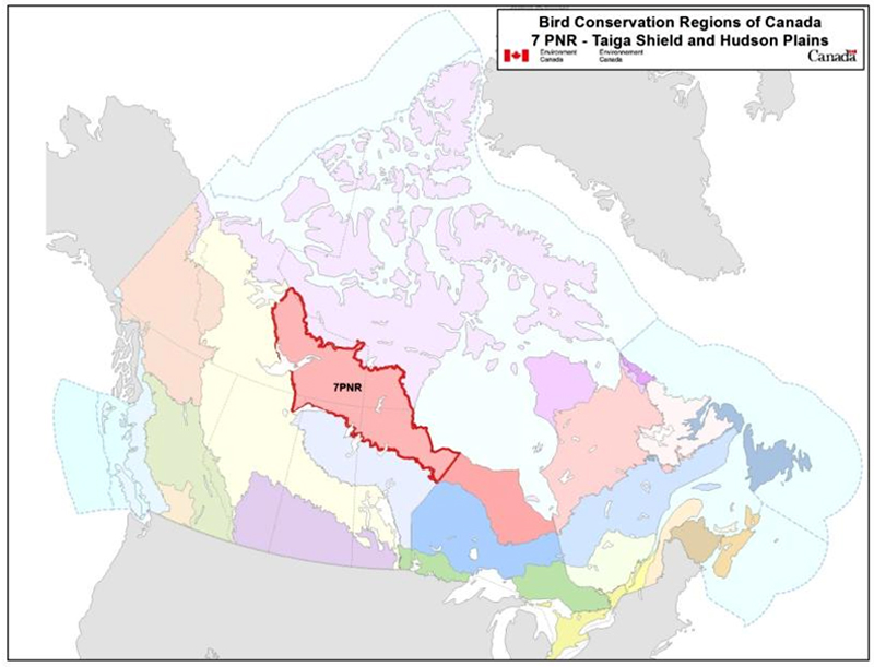
Text Description for BCR 7-PNR Map
Map of the Bird Conservation Regions (BCRs) of Canada with BCR 7, Prairie and Northern Region: Taiga Shield and Hudson Plains highlighted in light red with a red outline. Canada (with Alaska, Greenland and the northern portion of the United States of America also appearing, in grey) is shown very washed out, as it is only present to provide context for the location of the highlighted BCR 7PN. The washed out Canadian map is divided by BCR (12 Canadian BCRs in total), with various colours, and their exact locations and sizes are indistinguishable, aside from BCR 7PN.
The highlighted BCR 7PN extends from the eastern half of Northwest Territories, through southern Nunavut and northern Manitoba, to the Ontario border along Hudson Bay. The BCR is primarily situated in the Northwest Territories, in an east-west swath north of the boreal forest and straddling the tree line. Its southern borders also include the northern most portions of Saskatchewan and Alberta. The following legend appears in the top right corner of the map: “Bird Conservation Regions of Canada. 7 PNR - Taiga Shield and Hudson Plains” and includes the Environment and Climate Change Canada logo, and the Government of Canada logo.
Executive Summary
The Prairie and Northern Region (PNR) portion of BCR 7 consists of the western portion of two Ecozones: the Taiga Shield and the Hudson Plains. This subregion of the Bird Conservation Region (BCR) stretches northwest from the Hudson Bay coast of Manitoba, through the Northwest Territories (N.W.T.) as far west as Great Bear Lake. Nearly half (49%) of the BCR area of about 700,000 km2 is in the N.W.T., with 28% in Manitoba, 15% in Nunavut, 7% in Saskatchewan, and 1% of the strategy area in the extreme northeast corner of Alberta.
This conservation strategy for BCR 7-PNR builds on existing bird conservation strategies and complements those created for the other BCRs across Canada. BCR strategies will serve as a framework for implementing bird conservation nationally, and also identify international conservation issues for Canada's priority birds. This strategy is not intended to be highly prescriptive, but rather is intended to guide future implementation efforts undertaken by various partners and stakeholders.
The vast majority of BCR 7-PNR is Crown land, although the western portion of the BCR lies within the Tłicho land claim. This land claim area includes private lands where the Tłicho exercise self-government status and a larger area that has a regime of co-management for wildlife issues. The northern margin of the BCR runs along the Arctic Plains, mostly following the treeline and with the southern fringes bordering much of the Boreal Shield and Boreal Plains Ecozones. Northern continental portions of the BCR mainly have stunted conifer forests with interspersed ponds and peatlands overlaying the granite bedrock of the Canadian Shield. Numerous lakes and ponds dot the landscape. Within the Hudson Bay Plains, coastal flood plains and marshland become dominant, as does a milder climate that plays a large role in flora and fauna composition. The principal river and drainage systems include the North Hudson Bay (Thelon) and the Mackenzie River catchment, with linkages to the Peace and Athabasca rivers.
Human disturbance is very limited in BCR 7-PNR. Nearly all settlements are on or near the boundary of the BCR, and industrial development is local and restricted in nature. The area with by far the most anthropogenic activity is near Yellowknife in the N.W.T. The main economic activity in the BCR is mining, but currently there is only one operating mine of any kind - the Snap Lake Diamond Mine of DeBeers Canada. There are many small, abandoned mines, several locations with potential mines in some stage of development, and mineral potential is high throughout the Taiga Shield. There is no forestry activity and fire suppression is usually limited to protecting “values at risk” such as industrial areas and settlements. Fires regularly burn large areas in the southern two-thirds of the BCR.
Sixty-two of the 195 species (32%) in BCR 7-PNR were assigned a priority ranking. Landbirds had the most priority species (22 of 106 species), followed by waterbirds (15 of 30), waterfowl (13 of 30) and shorebirds (12 of 29). Nine species are priorities because they were assessed as “at risk” by COSEWIC, 7 are listed on Schedule 1 of the federal Species at Risk Act, while 5 are listed provincially. Wetlands and waterbodies were the most often-used habitats when considering all priority species.
There is one significant conservation issue in BCR 7-PNR, the overabundance of the Lesser Snow Goose and rapidly growing populations of Ross's Goose. These birds have become extremely numerous in the past few decades, primarily as a result of agricultural practices along migration routes and in wintering areas, which provides a limitless food source for them. Massive flocks of these birds are having devastating effects on natural coastal grass and tundra habitat during the breeding season and migration, which in turn affects large numbers of other birds. This effect is limited in BCR 7-PNR to the coastal areas along Hudson Bay, in and near the white goose colonies, and in their nearby staging areas. While severe, it is a localized effect at the scale of the BCR. Because this and other threats to priority species are of low magnitude, conservation objectives and recommended actions have not been developed in this strategy.
The only widespread issue that clearly applies to BCR 7-PNR is climate change. The impact of pollution, bird-structure collisions and predation by cats were considered minor threats. Additional threats may be located outside the BCR, particularly for long-distance migrants that may be impacted in their wintering habitat or important staging areas in the United States, Central/South America or the Caribbean islands. Major international threats include coastal development, deforestation, and agricultural expansion and intensification.
Population objectives and conservation needs are difficult to determine accurately because there is very little bird monitoring in BCR 7-PNR. Monitoring is restricted to two localized surveys for landbirds, a local, long-term waterfowl productivity study and annual spring waterfowl aerial transects. All this monitoring is in the western edge of BCR 7-PNR. Therefore, no good BCR-wide breeding season data exist for any species. The net result of this lack of comprehensive monitoring is that many population objectives are set as assess or maintain because the BCR population trend is not known.
Overall the key messages for bird conservation in BCR 7-PNR are:
- Development pressure is currently low, is mostly at the margins of the BCR, and, for the foreseeable future, is expected to remain best managed as site-specific concerns that are dealt with through the existing environmental assessment regulatory system.
- The existing conservation concern is related to overabundant white geese near Hudson Bay; this concern has international attention for management approaches.
- Monitoring data are so limited that BCR subregion-specific information on population trends cannot be generated; this is a primary need for determining the regional status of populations.
Introduction: Bird Conservation Strategies
Context
This document is one of a suite of Bird Conservation Region Strategies (BCRstrategies) that have been drafted by Environment and Climate Change Canada for all regions of Canada. These strategies respond to Environment and Climate Change Canada's need for integrated and clearly articulated bird conservation needs to support the implementation of Canada's migratory birds program, both domestically and internationally. This suite of strategies builds on existing conservation plans for the four “bird groups” (waterfowl Footnote[1], waterbirdsFootnote[2], shorebirdsFootnote[3] and landbirdsFootnote[4]) in most regions of Canada, as well as on national and continental plans, and includes birds under provincial/territorial jurisdiction. These new strategies also establish standard conservation planning methods across Canada, and fill gaps, as previous regional plans do not cover all areas of Canada or all bird groups.
These strategies present a compendium of required actions based on the general philosophy of achieving scientifically based desired population levels as promoted by the four pillar initiatives of bird conservation. Desired population levels are not necessarily the same as minimum viable or sustainable populations, but represent the state of the habitat/landscape at a time prior to recent dramatic population declines in many species from threats known and unknown. The threats identified in these strategies were compiled using currently available scientific information and expert opinion. The corresponding conservation objectives and actions will contribute to stabilizing populations at desired levels.
The BCR strategies are not highly prescriptive. In most cases, practitioners will need to consult additional information sources at local scales to provide sufficient detail to implement the recommendations of the strategies. Tools such as beneficial management practices will also be helpful in guiding implementation. Partners interested in participating in the implementation of these strategies, such as those involved in the habitat Joint Ventures established under the North American Waterfowl Management Plan (NAWMP), are familiar with the type of detailed implementation planning required to coordinate and undertake on-the-ground activities.
Strategy Structure
Section 1 of this strategy, published here, presents general information about the BCR and the subregion, with an overview of the six elementsFootnote[5] that provide a summary of the state of bird conservation at the sub-regional level. Section 2, included in the full version of the strategy, provides more detail on the threats, objectives and actions for priority species grouped by each of the broad habitat types in the subregion. Section 3, also part of the full strategy, presents additional widespread conservation issues that are not specific to a particular habitat or were not captured by the threat assessment for individual species, as well as research and monitoring needs, and threats to migratory birds while they are outside of Canada. The approach and methodology are summarized in the appendices of the full strategy, but details are available in a separate document (Kennedy et al. 2012). A national database houses all the underlying information summarized in this strategy and is available from Environment and Climate Change Canada.
Characteristics of Bird Conservation Region 7 Prairie and Northern Region
The Prairie and Northern Region (PNR) portion of BCR 7 is comprised of portions of two Canadian Ecozones: the western half of the Taiga Shield, and the western portion of the Hudson Plains. The PNR subregion of BCR 7 is approximately 700,710 km2, or 40% of the total BCR 7 area in Canada. It borders the waters of Hudson Bay and the Arctic Plains of Nunavut and Northwest Territories to the north, by the Boreal Softwood Shield to the south, and on the west by the Boreal Taiga Plains in Alberta and the Northwest Territories (Figure 1). The portion of BCR 7-PNR that consists of Coastal Hudson Bay Lowland is primarily salt marsh containing eel grass and other salt-tolerant species that follow along coastal regions. These ocean-influenced habitats transition into fens, bogs and areas of tundra farther inland. The continental inland portion of BCR 7-PNR is in the Taiga Shield Ecozone. The western portion of the BCR subregion stretches through southern Nunavut (15% of the subregion) and then into the Northwest Territories (49% of the subregion), bordering the Arctic Ecozone near Great Bear Lake. The remaining 36% of the subregion is in the northern Prairie provinces, with Manitoba having the second-largest portion of the area (28%), followed by Saskatchewan (7%), and a tiny portion of Alberta (1% of the subregion).
Figure 1: Map of BCR 7 showing the location of First Nations settled land claims, communities and provincial/territorial boundaries relative to the BCR boundary.
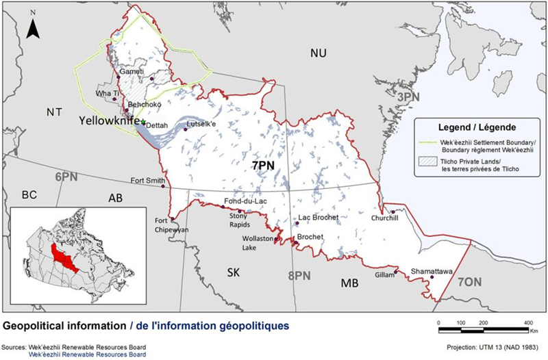
Text Description for Figure 1
Map of BCR 7 Prairie and Northern Region: Taiga Shield and Hudson Plains, showing the location of First Nations settled land claims, communities and provincial/territorial boundaries relative to the BCR boundary. The map's extent includes the areas immediately surrounding the BCR in the Northwest Territories, Nunavut, Ontario, Manitoba, Saskatchewan and Alberta. The borders of BCR 3PN, 6PN, 7ON, 8PN, and 8ON are delineated. BCR 7PN appears in colour (with a thick red line indicating its borders) while the others appear in grey. Inset in the lower left corner is a map of Canada with BCR 7PN highlighted in red. BCR 7PN extends from the eastern half of Northwest Territories, through southern Nunavut and northern Manitoba, to the Ontario border along Hudson Bay. The BCR is primarily situated in the Northwest Territories, in an east-west swath north of the boreal forest and straddling the tree line. Its southern borders also include the northern most portions of Saskatchewan and Alberta. Most of the communities are along the western and southern borders of BCR7PN, and the two land claims indicated occur in central NT, north of Yellowknife.
There are two bilingual legends for this map. The first is inset and says: “Legend/Légende, Wek'èezhii Settlement Boundary/Boundary règlement Wek'èezhii, Tlicho Private lands/les terres privées de Tlicho”. The second legend appears below the map and says: “Geopolitical information/de l'information géopolitiques. Sources: Wek'èezhii Renewable Resources Board, Wek'èezhii Renewable Resources Board”
There is also a visual representation of scale for the map in the legend which indicates 0, 100, 200 and 400 kms. The Projection is UTM 13 (NAD 1983).
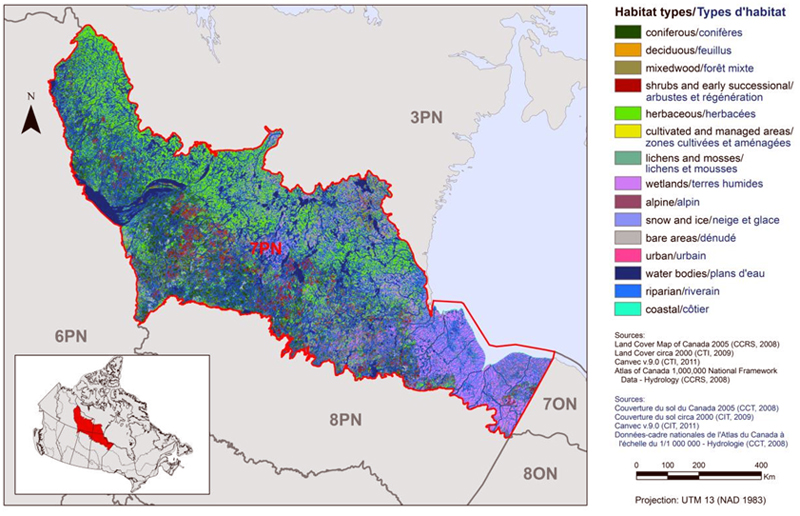
Habitat in BCR7-PNR is dominated by black spruce or jack pine forests of the Taiga Shield, which is interwoven with a network of peatlands, rivers, and innumerable ponds and lakes (Figure 2). General land cover is summarized in Figure 3 and Figure 4. Interested readers should consult Ecosystem Classification Group (2008) for detailed descriptions and images of all aspects of the geography, vegetation and other features of the Taiga Shield ecozone in the Northwest Territories. Willow and birch are important deciduous habitats in many shoreline and low-lying areas with soil development. Lowland areas have organic soils laid upon a foundation of Canadian Shield granite bedrock established during the Precambrian period. These saturated lowlands transition into shrublands as elevation increases, then into exposed upland areas that consist of tundra barrens colonized by small vascular plants, lichen and moss. Substantial areas have no continuous soil covering the exposed bedrock. The cold inland climate warms and transitions into a temperate coastal climate moving eastward toward Hudson Bay. This diverse landscape of the western extent of the Hudson Plains Ecozone is influenced greatly by oceanic influences from the east transitioning to freshwater ponds, tundra, and stunted forest from the west, and is important for many bird species that inhabit this large zone both seasonally and throughout the year.
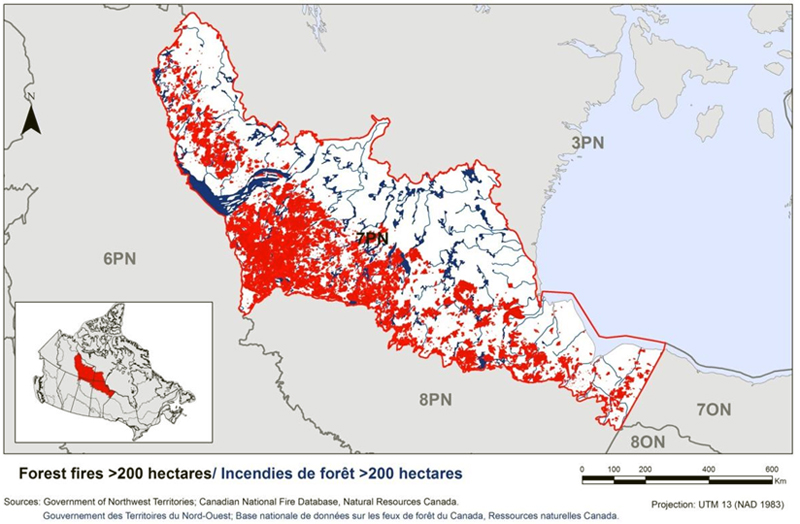
Natural disturbances in BCR 7-PNR are similar to those in the boreal region to the south but often without the restrictions imposed by humans such as fire suppression. Fire, insect outbreaks and extreme weather events (e.g., windstorms, heavy snow) impact regional vegetation as does grazing and browsing from mammals (e.g., caribou herds). Fires regularly burn extensive portions of the southern two-thirds of the BCR (Figure 5). Global climate change will impact these natural disturbance regimes (IPCC 2007).
The human population of all settlements in BCR 7-PNR is about 28,000, with the vast majority in the N.W.T. and Yellowknife in particular (20,000). The largest settlements in the provinces in the southern portion of the BCRcontain a thousand or fewer inhabitants each. Nearly all settlements are actually on or near the border of the BCR (Figure 1), making it one of the more sparsely populated BCRs in Canada. There are numerous protected areas in the BCR (Figure 6). Most are in the three provinces and are protected under provincial laws. Proposals for two new federally protected areas exist for areas over parts of Great Slave Lake.
Figure 2: An aerial view of habitat typical of BCR 7 in the Northwest Territories.
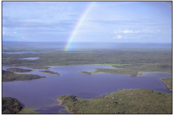
© Environment and Climate Change Canada - Photo: Craig Machtans
Figure 3: Landcover in BCR 7 Prairie and Northern Region.
Wetlands are difficult to separate without dominating the image; Figure 4 displays them preferentially.
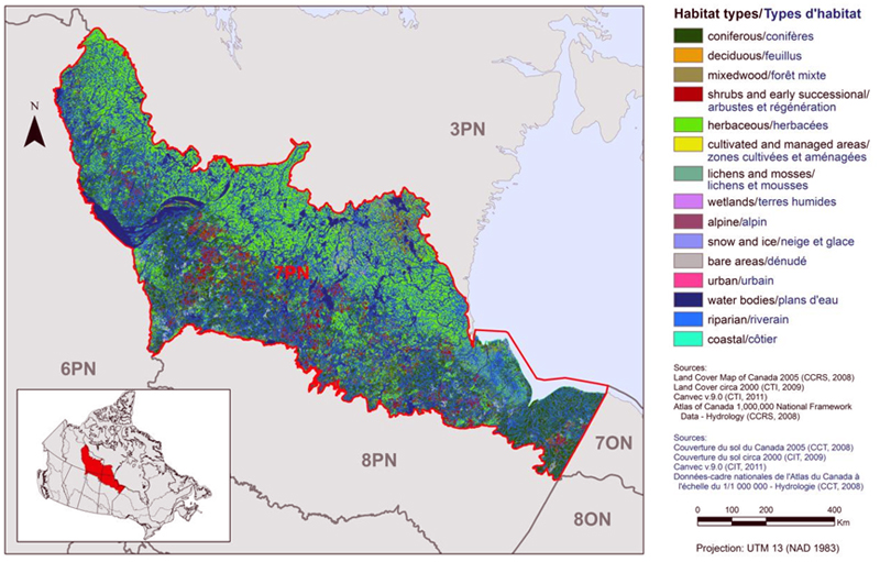
Text Description for Figure 3
Map of the landcover in BCR 7 Prairie and Northern Region: Taiga Shield and Hudson Plains. The map's extent includes the areas immediately surrounding the BCR in the Northwest Territories, Nunavut, Ontario, Manitoba, Saskatchewan and Alberta. The borders of BCR 3PN, 6PN, 7ON, 8PN, and 8ON are delineated. BCR 7PN appears in colour (with a thick red line indicating its borders) while the others appear in grey. Inset in the lower left corner is a map of Canada with BCR 7PN highlighted in red.
BCR 7PN extends from the eastern half of Northwest Territories, through southern Nunavut and northern Manitoba, to the Ontario border along Hudson Bay. The BCR is primarily situated in the Northwest Territories, in an east-west swath north of the boreal forest and straddling the tree line. Its southern borders also include the northern most portions of Saskatchewan and Alberta. The various habitat types that exist in the BCR are shown on the map in various colours, which are explained in the following bilingual legend (appearing to the right of the map):
- Coniferous/conifères
- Deciduous/feuillus
- Mixedwood/forêt mixte
- Shrubs and early successional/arbustes et regeneration
- Herbaceous/herbacées
- Cultivated and managed areas/zone cultivées et aménagées
- Lichens and mosses/lichens et mousses
- Wetlands/terres humides
- Alpine/alpin
- Snow and ice/neige et glace
- Bare areas/denude
- Urban/urbain
- Water bodies /plans d'eau
- Riparian/riverain
- Coastal/côtier
The most common habitat types visible at this scale in BCR 7PN are herbaceous (including tundra; more common in north), coniferous forests (more common in south) and waterbodies throughout. There is a moderate amount of shrub and early successional habitat in the southern 2/3 of the BCR, corresponding more or less to the burned areas. Riparian areas appear in high concentration in the east of the BCR (Hudson Plain). The other habitat categories are not obvious at this scale.
The remaining text in the legend is the following: Sources: Land Cover Map of Canada 2005 (CCRS, 2008), Land Cover circa 2000 (CTI, 2009), Canvec v 9.0 (CTI, 2011), Atlas of Canada 1,000,000 National Framework Data - Hydrology (CCRS, 2008). Sources: Couverture du sol du Canada 2005 (CCT, 2008), Couverture du sol circa 2000 (CIT, 2009), Canvec v 9.0 (CIT, 2011), Données-cadre nationales de l'Atlas du Canada à l'échelle du 1/1 000 000 - Hydrologie (CCT, 2008). There is also a visual representation of scale for the map in the legend which indicates 0, 100, 200 and 400 kms. The Projection is UTM 13 (NAD 1983).
Figure 4: Landcover in BCR 7 Prairie and Northern Region with wetlands displayed preferentially.
Text Description for Figure 4
Map of the landcover in BCR 7 Prairie and Northern Region: Taiga Shield and Hudson Plains, with wetlands displayed preferentially. The map's extent includes the areas immediately surrounding the BCRin the Northwest Territories, Nunavut, Ontario, Manitoba, Saskatchewan and Alberta. The borders of BCR 3PN, 6PN, 7ON, 8PN, and 8ON are delineated. BCR 7PN appears in colour (with a thick red line indicating its borders) while the others appear in grey. Inset in the lower left corner is a map of Canada with BCR 7PN highlighted in red.
BCR 7PN extends from the eastern half of Northwest Territories, through southern Nunavut and northern Manitoba, to the Ontario border along Hudson Bay. The BCR is primarily situated in the Northwest Territories, in an east-west swath north of the boreal forest and straddling the tree line. Its southern borders also include the northern most portions of Saskatchewan and Alberta. The various habitat types that exist in the BCR are shown on the map in various colours, which are explained in the following bilingual legend (appearing to the right of the map):
- Coniferous/conifères
- Deciduous/feuillus
- Mixedwood/forêt mixte
- Shrubs and early successional/arbustes et regeneration
- Herbaceous/herbacées
- Cultivated and managed areas/zone cultivées et aménagées
- Lichens and mosses/lichens et mousses
- Wetlands/terres humides
- Alpine/alpin
- Snow and ice/neige et glace
- Bare areas/denude
- Urban/urbain
- Water bodies /plans d'eau
- Riparian/riverain
- Coastal/côtier
The most common habitat types visible at this scale in BCR 7PN are herbaceous (including tundra; more common in north), coniferous forests (more common in south), waterbodies and wetlands throughout. Wetlands, as they are being displayed preferentially, appear in high concentration over the entire eastern portion of the BCR (Hudson Plain) and also in the central north portion. There is a moderate amount of shrub and early successional habitat in the southern 2/3 of the BCR, corresponding more or less to the burned areas. Riparian areas appear in high concentration in the east of the BCR and are associated with the wetlands (Hudson Plain). The other habitat categories are not obvious at this scale.
The remaining text in the legend is the following: Sources: Land Cover Map of Canada 2005 (CCRS, 2008), Land Cover circa 2000 (CTI, 2009), Canvec v 9.0 (CIT, 2011), Atlas of Canada 1,000,000 National Framework Data - Hydrology (CCRS, 2008). Sources: Couverture du sol du Canada 2005 (CCT, 2008), Couverture du sol circa 2000 (CIT, 2009), Canvec v 9.0 (CIT, 2011), Données-cadre nationales de l'Atlas du Canada à l'échelle du 1/1 000 000 - Hydrologie (CCT, 2008). There is also a visual representation of scale for the map in the legend which indicates 0, 100, 200 and 400 kms. The Projection is UTM 13 (NAD 1983).
Figure 5: The area of BCR 7 Prairie and Northern Region burned by forest fires (red areas) in the past 30-80 years.
Coverage is from 1965-2010 for Northwest Territories, 1931-2009 for Alberta, 1945-2010 for Saskatchewan, 1980-2008 for Manitoba.
Text Description for Figure 5
Area of BCR 7 Prairie and Northern Region burned by forest fires (red areas) in the past 30-80 years. The map's extent includes the areas immediately surrounding the BCR in the Northwest Territories, Nunavut, Ontario, Manitoba, Saskatchewan and Alberta. The borders of BCR3PN, 6PN, 7ON, 8PN, and 8ON are delineated. BCR 7PN appears in colour (with a thick red line indicating its borders) while the others appear in grey. Inset in the lower left corner is a map of Canada with BCR 7PN highlighted in red. BCR 7PN extends from the eastern half of Northwest Territories, through southern Nunavut and northern Manitoba, to the Ontario border along Hudson Bay. The BCR is primarily situated in the Northwest Territories, in an east-west swath north of the boreal forest and straddling the tree line. Its southern borders also include the northern most portions of Saskatchewan and Alberta. A large percent of the BCR area has been burned, with a patch distribution, with the majority of burns occurring along the lower 2/3 of the BCR. A legend appears below the map and says: "Forest fires >200 hectares / Incendies de forêt>200 hectares. Sources: Government of the Northwest Territories; Canadian National Fire Database, Natural Resources Canada. Gouvernement des Territories du Nord-Ouest; Base nationale de données sur les feux de forêt du Canada, Ressources naturelles Canada. There is also a visual representation of scale for the map in the legend which indicates 0, 100, 200, 400 and 600 kms. The Projection is UTM 13 (NAD 1983).
Figure 6: Protected and designated areas in and adjacent to BCR 7 Prairie and Northern Region.
The Ramsar site is the Peace-Athabasca Delta at the southwest tip of the BCR. Information on Important Bird Areas is available at IBA Canada. The numbered protected areas are: 1. Wood Buffalo National Park, 2. La Butte Creed Wildland Provincial Park, 3. Colin-Cornwall Lakes Wildland Provincial Park, 4. Tazin Lake Special Management Area, 5. Chappuis-Fontaine Lakes Special Management Area, 6. Misaw Lake Special Management Area, 7. Colvin Lake Provincial Park, 8. Nueltin Lake Provincial Park , 9. Baralzon Lake Ecological Reserve, 10. Caribou River Provincial Park, 11. Sand Lakes Provincial Park Reserve, 12. Numaykoos Lake Provincial Park, 13. Wapusk National Park, 14. Kaskatamagan Sipi Wildlife Management Area, 15. Kaskatamagan Wildlife Management Area, 16. Thelon Game Sanctuary. Not shown: Three territorial parks near Yellowknife, a proposal for Thaidene Nene National Park Reserve that covers part of the east arm of Great Slave Lake, and a candidate National Wildlife Area in the north arm of Great Slave Lake.
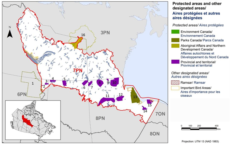
Text Description for Figure 6
Map of protected and other designated areas in BCR 7 Prairie and Northern Region: Taiga Shield and Hudson Plains. The map's extent includes the areas immediately surrounding the BCR in the Northwest Territories, Nunavut, Ontario, Manitoba, Saskatchewan and Alberta. The borders of BCR 3PN, 6PN, 7ON, 8PN, and 8ON are delineated. BCR 7PN appears in colour (with a thick red line indicating its borders) while the others appear in grey. Inset in the lower left corner is a map of Canada with BCR 7PN highlighted in red.
BCR 7PN extends from the eastern half of Northwest Territories, through southern Nunavut and northern Manitoba, to the Ontario border along Hudson Bay. The BCR is primarily situated in the Northwest Territories, in an east-west swath north of the boreal forest and straddling the tree line. Its southern borders also include the northern most portions of Saskatchewan and Alberta.
The various types of protected areas that exist in the BCR are shown on the map in various colours, which are explained in the following bilingual legend (appearing to the right of the map):
Protected areas/Aires protégées
- Environment and Climate Change Canada/Environnement et Changement climatique Canada
- Parks Canada/Parcs Canada
- Aboriginal Affairs and Northern Development Canada/Affaires autochtones et Développement du Nord Canada
- Provincial and territorial/Provincial et territorial
Other designated areas/Autres aires désignées
- Ramsar/Ramsar
- Important Bird Areas/Aires d'importance pour les oiseaux
The most common type of protected area shown is provincial, appearing as a patchwork throughout the eastern portion of the BCR. Two large National Parks occur, one within the BCR next to Hudson Bay, and another adjacent to the southwest corner of the BCR. There are several small Important Bird Areas throughout and one obvious AANDCarea.
There is also a visual representation of scale for the map in the legend which indicates 0, 100, 200 and 400 kms. The Projection is UTM 13 (NAD 1983).
Figure 7: Active mineral exploration projects in the northern part of BCR 7 Prairie and Northern Region as of 2012.
The Snap Lake Diamond mine owned by DeBeers Canada is the only active mine. Several mines are in the environmental assessment phase while other active properties are not as advanced.
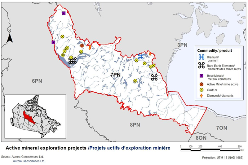
Text Description for Figure 7
Active mineral exploration projects in the northern part of BCR7 Prairie and Northern Region as of 2012. The map's extent includes the areas immediately surrounding the BCR in the Northwest Territories, Nunavut, Ontario, Manitoba, Saskatchewan and Alberta. The borders of BCR 3PN, 6PN, 7ON, 8PN, and 8ON are delineated. BCR 7PN appears in colour (with a thick red line indicating its borders) while the others appear in grey. Inset in the lower left corner is a map of Canada with BCR 7PN highlighted in red. BCR 7PN extends from the eastern half of Northwest Territories, through southern Nunavut and northern Manitoba, to the Ontario border along Hudson Bay. The BCR is primarily situated in the Northwest Territories, in an east-west swath north of the boreal forest and straddling the tree line. Its southern borders also include the northern most portions of Saskatchewan and Alberta. Most projects occur in two general areas: just north of Great Slave Lake and in the Nunavut portion of the BCR. There are several gold projects, two rare earth elements projects, two diamond projects, two base metals projects and one active mine in the area north of Great Slave Lake. There are several gold projects, one uranium project and one rare earth elements project in the Nunavut portion of the BCR.
There are two bilingual legends for this map. The first is inset and says:“Commodity/produit. Uranium/uranium, Rare Earth Elements/éléments des terres rares, Base Metals/ métaux commun, Active Mine/mine actif, Gold/or, Diamonds/diamants”. The second legend appears below the map and says: “Active mineral exploration projects / actives projets d'exploration minière. Source: Aurora Geosciences Ltd, Aurora Geosciences Ltd”. There is also a visual representation of scale for the map in the legend which indicates 0, 100, 200, 400 and 600 kms. The Projection is UTM 13 (NAD 1983).
The one settled land claim in the BCR is the Tłicho, found at the western end (see Figure 1). The significance of this land claim for bird conservation can be summarized as:
- The Tłįcho have a self-government claim, so they have the same status and management responsibilities as a province on their private lands.
- In the larger settlement boundary, there is a formal wildlife co-management regime with the Wek'éezhìi Renewable Resources Board. The board has legal jurisdiction to set a total harvest limit for species in its management area (if ever an upper cap was needed on harvest, as opposed to individual bag limits). The Canadian Wildlife Service has one member on the board and consults them on issues of wildlife management, including BCR strategies.
- The Wek'éezhìi board must be consulted on proposed listings under the Species at Risk Act and makes a recommendation to the Minister of the Environment.
In both the Taiga Shield and Hudson Plains portions of BCR 7-PNR, direct human impact on the surrounding landscape is still low compared to southern regions of the country where industry and human population exists at a much larger scale. Mining developments have been a part of the landscape for decades in the mineral rich Taiga Shield, where the mining of gold, nickel, and iron ore deposits used to lead the economy. More recently, there is one operating diamond mine, the Snap Lake Diamond Mine, and potential for various new mines as rare earth elements and uranium deposits are sought by developers (Figure 7). The Snap Lake Diamond Mine is an underground mine, and its entire infrastructure, including an airstrip, covers less than 500 ha of land. This is in contrast to the larger, combined open-pit and underground operations at the other two diamond mines nearby in BCR 3.
Three mines are currently in or entering the environmental assessment phase, all in the N.W.T. portion of the BCR. These industrial-scale mining activities typically have local impacts on the northern landscape, through mineral leaching and other toxic by-products of mining, habitat destruction while the mine is operating, and the creation of tailings ponds by some types of mines. Reclamation and financial deposits for that purpose are held by the federal government after project approval and are a requirement for modern mines.
Some portions of BCR 7-PNR, particularly in the coastal regions, but more recently in the tundra areas of the Hudson Plains, are under high pressure from overabundant Lesser Snow Geese and rapidly growing populations of Ross's Geese. The term “overabundant” is legally defined in the Migratory Birds Regulations (S. 23.1) as “…a species of migratory game bird that, as a result of the rate of increase of the population of that species or its overabundance, is injurious to or threatens agricultural, environmental or other similar interests”. The populations of geese have become extremely large due primarily to the vast agricultural areas along their migration routes which offer a virtually limitless food supply. This food supply dramatically increases over-winter survival and also allows geese to arrive on the breeding grounds in excellent physical condition. Impacts to the delicate ecosystems where these geese breed and stage can be devastating. At present this is the only pressing conservation issue involving birds directly within the BCR subregion.
Figure 8: Greater Yellowlegs is a priority species in BCR 7 Prairie and Northern Region because of national and regional concern. It is found in the western and southwestern portions of the BCR where it can easily be confused with the similar and more common Lesser Yellowlegs (also a priority species).
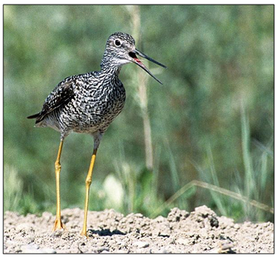
© Environment and Climate Change Canada - Photo: Craig Machtans
Section 1: Summary of Results - All Birds, All Habitats
Element 1: Priority Species Assessment
These Bird Conservation Strategies identify “priority species” from all regularly occurring bird species in each BCR subregion. Species that are vulnerable due to population size, distribution, population trend, abundance and threats are included because of their “conservation concern.” Some widely distributed and abundant “stewardship” species are also included. Stewardship species are included because they typify the national or regional avifauna and/or because they have a large proportion of their range and/or continental population in the subregion; many of these species have some conservation concern, while others may not require specific conservation effort at this time. Species of management concern are also included as priority species when they are at (or above) their desired population objectives but require ongoing management because of their socio-economic importance as game species or because of their impacts on other species or habitats.
The purpose of the prioritization exercise is to focus implementation efforts on the issues of greatest significance for Canadian avifauna. Table 1 provides a full list of all priority species and their reason for inclusion. Tables 2 and 3summarize the number of priority species in BCR 7 Prairie and Northern Region by bird group and by the reason for priority status.
Table 1: Priority species in BCR 7, Prairie and Northern Region, population objective, and the reason for priority status. Accessible Version of Table 1.
| Bird Group | Total Species |
Total Priority Species | Percent Listed as Priority | Percent of Priority List |
|---|---|---|---|---|
| Landbird | 106 | 22 | 21% | 36% |
| Shorebird | 29 | 12 | 41% | 19% |
| Waterbird | 30 | 15 | 50% | 24% |
| Waterfowl | 30 | 13 | 43% | 21% |
| Total | 195 | 62 | 32% | 100% |
| Priority ListingReturn to footnote[1] | Landbirds | Shorebirds | Waterbirds | Waterfowl |
|---|---|---|---|---|
| COSEWICReturn to footnote[2] | 6 | 0 | 3 | 0 |
| Federal SARA listedReturn to footnote[3] | 5 | 0 | 2 | 0 |
| Provincially ListedReturn to footnote[4] | 3 | 0 | 1 | 1 |
| NAWMPReturn to footnote[5] | - | - | - | 12 |
| National/Continental Concern | 11 | 10 | 13 | 9 |
| Regional/Concern | 0 | 12 | 14 | 10 |
| National/Continental Stewardship | 9 | - | - | - |
| Regional Stewardship | 10 | 6 | 7 | 8 |
| Management ConcernReturn to footnote[6] | 0 | 0 | 0 | 1 |
Element 2: Habitats Important to Priority Species
Identifying the broad habitat requirements for each priority species within the BCR allowed species to be grouped by shared habitat-based conservation issues and actions. If many priority species associated with the same habitat face similar conservation issues, then conservation action in that habitat may support populations of several priority species. BCR strategies use a modified version of the standard land cover classes developed by the United Nations (Food and Agriculture Organization 2000) to categorize habitats and species were often assigned to more than one habitat class.
Figure 9 provides a summary of habitats used by the priority species. Habitat use for each species was not ranked, so the figure does not represent a corresponding overall importance of particular habitats in the BCR. It only shows, for example, that many priority species use wetlands or waterbodies as one of their main habitat choices.
Figure 9: Percent of priority species that are associated with each habitat type in BCR 7 Prairie and Northern Region. The full habitat class name for Urban is “Urban (Artificial Surfaces and Bare Areas)”.
Note: The total exceeds 100% because each species may be assigned to more than one habitat.
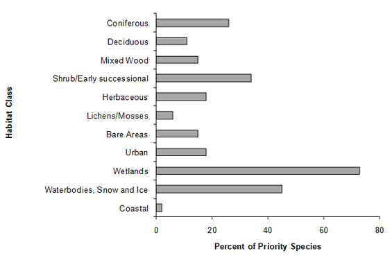
Text Description for Figure 9
A horizontal bar graph indicating the percent of priority species (x axis) that are associated with each habitat class (y axis, coniferous; deciduous; mixed wood; shrub/early successional; herbaceous; lichens/mosses; bare areas; urban; wetlands; waterbodies, snow and ice; and coastal in BCR 7 Prairie and Northern region. Note: The total exceeds 100% because each species may be assigned to more than one habitat.
| Habitat class | Percent of Priority Species |
|---|---|
| Coniferous | 26 |
| Deciduous | 11 |
| Mixed Wood | 15 |
| Shrub/Early Successional | 34 |
| Herbaceous | 18 |
| Lichens/Mosses | 6 |
| Bare Areas | 15 |
| Urban | 18 |
| Wetlands | 73 |
| Waterbodies, Snow and Ice | 45 |
| Coastal | 2 |
Element 3: Population Objectives
Population objectives allow us to measure and evaluate conservation success. The objectives in this strategy are assigned to categories and are based on a quantitative or qualitative assessment of species' population trends. If the population trend of a species is unknown, the objective is set as “assess and maintain,” and a monitoring objective is given. For any species listed under the Species at Risk Act (SARA) or under provincial/territorial endangered species legislation, Bird Conservation Strategies defer to population objectives in available Recovery Strategies and Management Plans. The ultimate measure of conservation success will be the extent to which population objectives have been reached over the next 40 years. Population objectives do not currently factor in feasibility of achievement, but are held as a standard against which to measure progress.
Figure 10 summarizes the proportion of population objectives for priority species in BCR 7-PNR. The vast majority of the species were data deficient for regional trend information. Where no defendable alternative could be found, “assess/maintain” was assigned as the population objective. Although consistency with adjacent BCRs (especially BCR 7 - Ontario region and BCR 3 - PNR) was desirable, there are exceptions where species do not have identical objectives. For instance, Harris's Sparrow has an objective of “Increase 100%” in BCR 7 - PNR where the vast majority of its breeding range occurs. Data on trend come from Christmas Bird Counts, likely a valid representation given the high overlap of this species' range with the BCR boundaries. By contrast, BCR 7 - Ontario Region overlaps very little of the range of this species and has set “assess/maintain” as the appropriate target. Notes on these differences and the underlying reasoning are contained in the national database.
Figure 10: Percent of priority species that are associated with each population objective category in BCR 7, Prairie and Northern Region.
Many species have “Assess/Maintain” because of the paucity of monitoring data from within the BCR.
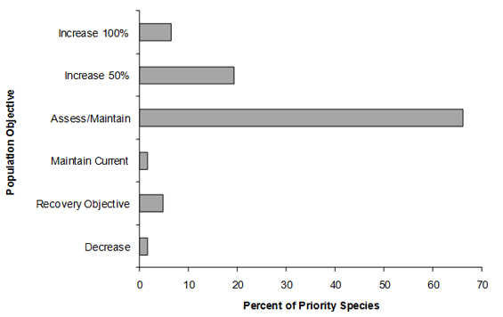
Text Description for Figure 10
A horizontal bar graph indicating the percent of priority species (x axis) that are associated with each population objective (y axis; increase 100%, increase 50%, assess/maintain, maintain current, recovery objective, decrease) in BCR 7 Prairie and Northern Region.
| Population Objective | Percent of Priority Species |
|---|---|
| Increase 100% | 6.5 |
| Increase 50% | 19.4 |
| Assess / Maintain | 66.1 |
| Maintain current | 1.6 |
| Recovery objective | 4.8 |
| Decrease | 1.6 |
Element 4: Threat Assessment for Priority Species
The threats assessment process identifies threats believed to have a population-level effect on individual priority species. These threats are assigned a relative magnitude (Low, Medium, High, Very High), based on their scope (the proportion of the species' range within the subregion that is impacted) and severity (the relative impact on the priority species' population). This allows us to target conservation actions towards threats with the greatest effects on suites of species or in broad habitat classes. Some well known conservation issues (such as predation by domestic cats or climate change) may not be identified in the literature as significant threats to populations of an individual priority species and therefore may not be captured in the threat assessment. However, they merit attention in conservation strategies because of the large numbers of individual birds affected in many regions of Canada. We have incorporated them in a separate section on Widespread Issues in the full strategy, but, unlike other threats, they are not ranked.
Because development is so limited in BCR 7-PNR, no threats were identified as operating at a level that affects populations of priority species. However, the following threats were initially identified and considered:
- Urban expansion of the communities in the BCR subregion
- Mining and quarrying
- Overabundant native species
- Dams/hydro development
- Roads
Forest harvesting, salvage logging, and peat mining do not occur in the BCR so are not listed as threats. Fire suppression is mostly limited to protecting communities and industry sites or some localized timber resources. Most fires are allowed to burn extensive areas under natural conditions (Figure 5), unless coming close to human property, so no human-caused effect on bird populations from fire suppression could be identified. As per the methodology in Kennedy et al. (2012), threats identified as “Low” are not considered further for Conservation Objectives or Recommended Actions. Since all threats in BCR 7 were deemed to be “Low,” this strategy has no Element 5 or 6 results. However, there are two conservation issues in the BCR, both relatively local in scale: overpopulation of two species of goose, the Lesser Snow Goose and Ross's Goose, and overpopulation of Common Ravens around Yellowknife and nearby settlements.
Overabundant White Geese
Ecosystems within BCR 7-PNR, particularly in the coastal regions, but more recently in the tundra areas of the Hudson Plains, are under high pressure from a large overabundance of Lesser Snow Geese (Figure 11) and rapidly growing populations of Ross's Geese. A special publication from the Arctic Goose Joint Venture (Leafloor et al. 2012) is a current and expansive review of the situation and conservation options for dealing with this issue. Lesser Snow Goose populations have increased at a remarkable rate, up to 7% per year from the early 1960s to the mid-1990s, due primarily to the agricultural food resources available throughout their migratory routes and on their wintering grounds (Abraham et al. 2005). The abundance of these herbivores on breeding areas in BCR 7-PNR is causing loss or degradation of habitat for a variety of other bird species, and may, over time, cause changes in bird communities in the affected habitats. For example, Savannah Sparrows and their grass/shrub habitat showed large declines, up to 77%, over a 25-year period from 1976 to 2001 in an area adjacent to coastal salt marshes in northern Manitoba (Rockwell et al.2003). This is attributed to destructive foraging by snow geese causing changes in the properties of the soil, and erosion of the unvegetated soils resulting in potentially irreversible changes (Jefferies et al. 2006). Decreasing Snow and Ross's Goose numbers will likely require large-scale, intensive management efforts since recent evidence suggests that increased bag limits and the special conservation season (spring hunt) are not curtailing population growth as much as expected (Leafloor et al. 2012).
Figure 11: Lesser Snow Geese are overabundant and are severely damaging their breeding habitats.

© Environment and Climate Change Canada - Photo: Craig Machtans
The issue of overabundant Lesser Snow Geese and similarly destructive increasing populations of Ross's Geese is a serious, but local problem in the BCR (restricted to the area near Churchill, MB). BCR 3-PNR contains many more white-goose colonies, and that strategy has both Conservation Objectives and Recommended Actions for these species that would also apply to the white geese in BCR 7-PNR.
Overabundant Ravens
Yellowknife has the highest count of Common Ravens (Figure 12) in North America on the Christmas Bird Count, with 2,613 and 2,221 individuals found in the 2010 and 2011 counts respectively. This local overpopulation has been linked to decreased nesting success in several waterbird and waterfowl species in the area, likely due to increased nest predation (Fournier and Hines 1999, 2001, Canadian Wildlife Service unpublished data). For example, scaup nesting success averages 58% where ravens are excluded, but is 18-21% on land or islands accessible to ravens (although the latter are free of terrestrial predators). Similar effects were noted on waterfowl and waterbirds nesting in the Yellowknife area.
Figure 12: Common Ravens have become very numerous in the Yellowknife area, resulting in negative effects on local waterfowl nesting success.
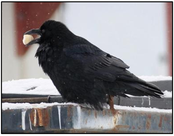
© Environment and Climate Change Canada - Photo: Craig Machtans
Mining
Mining is the main industry in the BCR subregion, as mentioned earlier. Though the threat from mining to birds in BCR 7-PNR is likely below the threshold for consideration at this regional scale, mining has historically been more active and is likely to increase with three potential new mines coming into operation. Impacts will still remain local in scope and can be dealt with by participation in the environmental assessment process and compliance with regulatory conditions of licenses and authorizations.
Figure 13 summarizes the six sub-threats that affect priority species in BCR 7-PNR. “Mining and quarrying” usually refers to the direct loss of habitat and any indirect effects from the mines on habitat such as dust and noise. “Recreational activities” are primarily those involving use of lakes and wetlands and the associated boat wakes, noise or pollution. “Problematic native species” is mostly a threat from white goose overpopulation, but it does include unusually high numbers of Common Ravens around Yellowknife and the associated depredation of nests mentioned above. The “Industrial and military effluents” sub-category covers mercury, selenium and other metals, as well as complex chemicals such as PCBs or flame retardants. They are deposited locally from industry or by long-range atmospheric transport and bioaccumulate in birds. “Garbage and solid waste” is self-explanatory and was assessed for gulls. Finally, “Air-borne pollutants” was used for aerial deposition of compounds that acidify the environment.
Figure 13: Percent of identified threats to priority species within BCR 7, Prairie and Northern Region, by threat sub-category.
Each bar represents the percent of the total number of threats identified in each threat sub-category in BCR 7-PNR (for example, if 100 threats were identified in total for all priority species in BCR 7-PNR, and 10 of those threats were in the category 3.2 - Mining and quarrying, the bar on the graph would represent this as 10%). Shading in the bars (VH = very high, H = high, M = medium and L = low) represents the rolled up magnitude of all threats in each threat subcategory in the BCR.
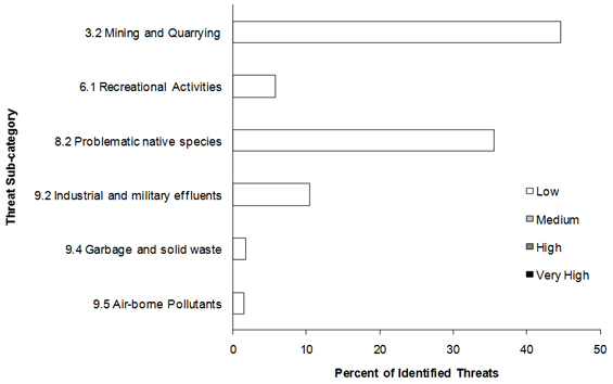
Text Description for Figure 13
A horizontal bar graph indicating the percent of identified threats to priority species (x axis) within BCR 7 Prairie and Northern Region by threat subcategory (y axis; i.e. mining and quarrying, airborne pollutants, etc).
Each bar represents the percent of the total number of threats identified in each sub-threat category in BCR 7-PNR (for example, if 100 threats were identified in total for all priority species in BCR 7-PNR, and 10 of those threats were in the category 3.2 - Mining and quarrying, the bar on the graph would represent this as 10%). Shading in the bars (VH = very high, H = high, M = medium and L = low) represents the rolled up magnitude of all threats in each threat subcategory in the BCR.
| Threat Sub-category | % Low |
|---|---|
| 3.2 Mining and quarrying | 44.6 |
| 6.1 Recreational activities | 5.76 |
| 8.2 Problematic native species | 35.6 |
| 9.2 Industrial and military effluents | 10.4 |
| 9.4 Garbage and solid waste | 1.8 |
| 9.5 Airborne pollutants | 1.4 |
Overall threats were summarized for the strategy subregion in Table 4. Like the data presented above, sub-categories 2. Energy Production and Mining and 8. Invasive and Other Problematic Species and Genes are the two main threats. However, the table demonstrates that both of these low ranked threats were assessed to occur in most habitat classes. The overall threat ranking in each habitat is in the top row, while the overall threat ranking for each threat is in the last column.
Table 4: Relative magnitude of identified threats to priority species within BCR 7, Prairie and Northern Region, by threat category and broad habitat class. Accessible Version of Table 4.
Threats to priority species while they are outside Canada during the non-breeding season were also assessed and are presented in the full strategy in the Threats Outside Canada section.
Element 5: Conservation Objectives
Conservation objectives were designed to address threats and information gaps that were identified for priority species. They describe the environmental conditions and research and monitoring that are thought to be necessary for progress towards population objectives and to understand underlying conservation issues for priority bird species. As conservation objectives are reached they will collectively contribute to achieving population objectives. Whenever possible, conservation objectives were developed to benefit multiple species, and/or respond to more than one threat.
For BCR7-PNR no threats identified for individual species were assessed at a magnitude of “medium” or greater. Therefore no specific conservation objectives or associated actions were developed as per Kennedy et al. (2012). See the BCR 3-PNR strategy for conservation objectives and recommended actions for overabundant white geese.
Element 6: Recommended Actions
Recommended actions indicate on-the-ground activities that will help to achieve the conservation objectives. Actions are strategic rather than highly detailed and prescriptive. Whenever possible, recommended actions benefit multiple species, and/or respond to more than one threat. Recommended actions defer to or support those provided in recovery documents for species at risk at the federal, provincial or territorial level, but will usually be more general than those developed for individual species.
For BCR7-PNR no threats identified for individual species were assessed at a magnitude of “medium” or greater. Therefore no specific conservation objectives or associated actions were developed as per Kennedy et al. (2012). Many of the threats facing priority bird species in BCR 7-PNR are not well understood; this may be due to inadequate monitoring for most species that leads to uncertainty in BCR population trends, or a lack of evidence establishing causative relationships between human activities and population declines. These knowledge gaps will often be best addressed using an adaptive management approach which iteratively employs management actions as scientific experiments to test specific hypotheses to inform future management decisions (Walters et al. 1992).
References
Abraham, K. F., R. L. Jefferies and R. T. Alisauskas, 2005. The dynamics of landscape change and snow geese in mid-continent North America. Global Change Biology 11: 841-855.
Donaldson, G. M., C. Hyslop, R. I. G. Morrison, H. L. Dickson, and I. Davidson (editors). 2000. Canadian Shorebird Conservation Plan. Canadian Wildlife Service, Environment and Climate Change Canada, Ottawa, Ontario. 27pp.
Ecosystem Classification Group. 2008. Ecological regions of the Northwest Territories - Taiga Shield. Department of Environment and Natural Resources, Government of the Northwest Territories, Yellowknife, NT, Canada. viii + 146 pp. + insert map.
Food and Agriculture Organization (FAO). 2000. Land cover classification system. United Nations Food and Agriculture Organization, Rome.
Fournier, M. A. and J. E. Hines. 1999. Breeding ecology of the Horned Grebe Podiceps auratus in subarctic wetlands. Occasion Paper 99, Canadian Wildlife Service, Ottawa, ON.
Fournier, M. A. and J. E. Hines. 2001. Breeding ecology of sympatric Greater and Lesser Scaup (Aythya marila andAythya affinis) in the Subarctic Northwest Territories. Arctic 54:444-456.
IPCC, 2007: Climate Change 2007: Synthesis Report. Contribution of Working Groups I, II and III to the Fourth Assessment Report of the Intergovernmental Panel on Climate Change [Core Writing Team, Pachauri, R.K and Reisinger, A. (eds.)]. IPCC, Geneva, Switzerland, 104 pp.
Jefferies, R. L., P. J. Andrew and K. F. Abraham, 2006. A biotic agent promotes large-scale catastrophic change in the coastal marshes of Hudson Bay. Journal of Ecology 94: 234-242.
Kennedy, J.A., E.A. Krebs and A.F. Camfield. 2012. A Manual for Completing All-bird Conservation Plans in Canada, April 2012 version. Canadian Wildlife Service, Environment and Climate Change Canada. Ottawa, ON
Leafloor, J. O., T. J. Moser, and B. D. J. Batt (editors). 2012. Evaluation of special management measures for midcontinent lesser snow geese and Ross's geese. Arctic Goose Joint Venture Special Publication. U.S. Fish and Wildlife Service, Washington, D.C. and Canadian Wildlife Service, Ottawa, Ontario.
Milko, R., L. Dickson, R. Elliot, and G. Donaldson. 2003. Wings Over Water: Canada's Waterbird Conservation Plan. Canadian Wildlife Service, Environment and Climate Change Canada, Ottawa, Ontario. 28pp.
North American Waterfowl Management Plan, Plan Committee. 2004. North American Waterfowl Management Plan 2004. Implementation Framework: Strengthening the Biological Foundation. Canadian Wildlife Service, U.S. Fish and Wildlife Service, Secretaria de Medio Ambiente y Recursos Naturales, 106pp.
Rich, T. D., C. J. Beardmore, H. Berlanga, P. J. Blancher, M. S. W. Bradstreet, G. S. Butcher, D. W. Demarest, E. H. Dunn, W. C. Hunter, E. E. Iñigo-Elias, J. A. Kennedy, A. M. Martell, A. O. Panjabi, D. N. Pashley, K. V. Rosenberg, C. M. Rustay, J. S. Wendt, T. C. Will. 2004. Partners in Flight North American Landbird Conservation Plan. Cornell Lab of Ornithology. Ithaca, NY.
Rockwell, R.F., R.L. Jefferies, and P.J. Weatherhead, 2003. Response of nesting savannah sparrows to 25 years of habitat change in a snow goose colony. Ecoscience, 10 (1): 33-37.
Species at Risk Public Registry. Accessed 4 April 2012. Schedule 1: List of Wildlife Species at Risk.
Walters, C., G. Gunderson, and C. S. Holling. 1992. Experimental policies for water management in the Everglades. Ecological Applications 2:189-202.