Tintamarre National Wildlife Area Management Plan: chapter 1
1 Description of the Protected Area
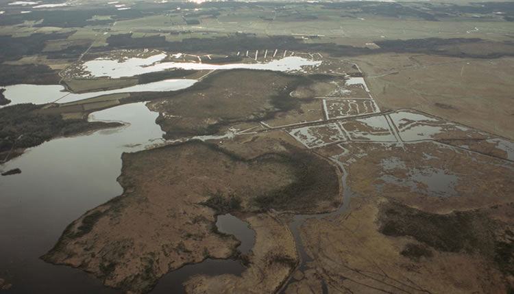
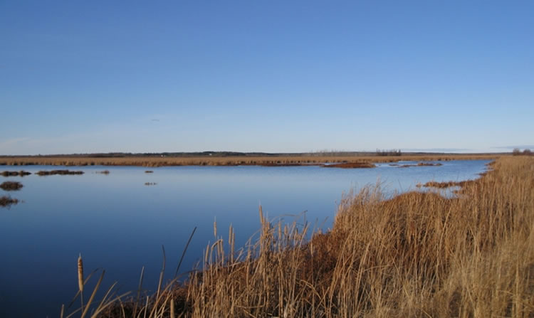
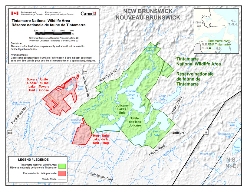
Tintamarre National Wildlife Area (NWA) is located in southeastern New Brunswick (45° 58'N 64° 16'W). Tintamarre NWA was established in 1978 to protect waterfowl habitat (Table 1). This 1990-ha protected area contains extensive tracts of marshes, fens, bogs, swamps and woodlands (Figure 1). Three large lakes, Jolicure Large Lake, Long Lake and Front Lake, are among the site's most prominent features. Collectively, these wetland and peatland habitats comprise 79.5% (1580 ha) of the NWA (Figure 2). All three lakes within the NWA are relatively shallow (1.5-2.0 m). Jolicure Large Lake has significant areas of open water, while Long Lake and Front Lake are more characterized by narrow zones of emergent vegetation, principally Cattail (Typha spp.) and Round-stem Bulrush (Scirpus validus). Efforts are currently under way to acquire and designate additional lands: the proposed Towers Goose Lake and Hog Lake units (Figure 2).
Tintamarre NWA protects some of the largest remaining tracts of peatlands in southeastern New Brunswick. These large and open raised bogs are characterized by deep peat deposits. The dominant plant cover is typically an expanse of Sphagnum (predominantly Sphagnum rubrum) surrounded by a narrow fringe of Black Spruce (Picea mariana). Within the floating Sphagnum are typically clumps of Leatherleaf (Chamaedaphne calyculata) and Pale Laurel (Kalmia polifolia) with creeping ground cover of Bog Cranberry (Vaccinium macrocarpon) and Crowberry (Empetrum nigrum). In the other zones of the NWA, Sphagnum moss is less dominant, with heath shrubs and stunted trees including Larch (Larix laricina) and Black Spruce becoming progressively more prevalent.
The development of controlled water-level impoundments began in 1967 with the assistance of Ducks Unlimited Canada. Thirteen separate marsh impoundments totalling 890 ha have been developed through a system of dykes and control structures (Figure 1). Some of these impoundments were constructed predominantly on drained and abandoned agricultural dykelands, while others aid in retaining water within the larger lake basins. Emergent and submergent vegetation within these managed wetlands include Broadleaf Cattail (Typha latifolia), Narrow Leaf Cattail (Typha angustifolia), Giant Burreed (Sparganium eurycarpum), Bladderwort (Utricularia spp.) and small pondweeds such as Slender Pondweed (Potamogeton pusillus).
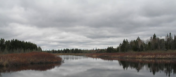
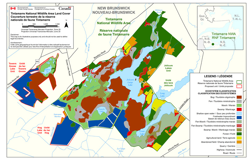
The uplands of Tintamarre NWA consist mainly of dense forests of coniferous trees, as well as remnants of abandoned farms and agricultural lands on the periphery (Figure 3). Several additional upland parcels, formerly cultivated, are now in various stages of old field and forest succession. The most recently abandoned sites are primarily vegetated by grasses and other herbaceous species with thickets of Hardhack (Spirea latifolia) on poorer soils, whereas other areas support various shrubs and young softwood trees. The forest cover in the NWA consists principally of conifers such as Black Spruce, Red Spruce (Picea rubens), Balsam Fir (Abies balsamea) and Larch. Black Spruce and Larch are found generally on the more poorly drained sites and provide the tree cover of wooded bogs. Most upland sites are covered by younger forest stands; however, some areas support more mature woodlands dominated by deciduous trees such as White Birch (Betula papyrifera), Yellow Birch (Betula lutea), Red Maple (Acer rubrum) and Sugar Maple (Acer saccharum).
| Category | Information |
|---|---|
| Protected area designation | National Wildlife Area |
| Province or territory | New Brunswick |
| Latitude and longitude | 45° 58’N 64° 16’W |
| Size (ha) | 1990 ha |
| Protected area designation criteria | Historic: Protecting a significant wetland complex of bogs, lakes and fens at the head of the Bay of Fundy that functions as an important area for waterfowl. Current: Criteria 1(a), where “the area supports a population of a species or subspecies or a group of species that is concentrated, for any portion of the year”. A significant number and diversity of waterfowl use the protected area as breeding or migration habitat. |
| Protected area classification system | The area possesses a high research potential for restoration and enhancement of migratory bird populations to national population targets (Environment Canada 2005). |
| International Union for Conservation of Nature (IUCN) classification | Category IV: Managed for conservation of habitat and species through management intervention. |
| Order in Council number | P.C. 1978-1439 |
| Directory of Federal Real Property (DFRP) number | DFRP number04315 |
| Gazetted | 27 April 1978 |
| Additional designations | Grassy Hole Lakes proposed as an Ecological Reserve through the International Biological Program. |
| Faunistic and floristic importance | Wetland complex of lakes, streams, bogs, open marshes and fens at the headwaters of the Bay of Fundy supports a diversity of waterfowl and wetland birds. |
| Invasive species | Purple Loosestrife (Lythrum salicaria), Buckthorn (Rhamnus frangula), Japanese Knotweed (Fallopia japonica), Reed Grass (Phragmites communis [alpestris]) and Reed Canary Grass (Phalaris arundinacea) |
| Species at risk | The National Wildlife Area supports five species at risk under the federal Species at Risk Act: Chimney Swift (Chaetura pelagicaI), Common Nighthawk (Chordeiles minor), Least Bittern (Ixobrychus exilis), Monarch (Danaus plexippus) and Short-eared Owl (Asio flammeus). |
| Management agency | Environment and Climate Change Canada, Canadian Wildlife Service |
| Public access and use | No public facilities on site. Low-level use consists of traditional activities such as hunting, fishing, trapping, canoeing, birdwatching, and berry picking (mainly bog cranberry). |
Long description for Figure 2
Map showing the boundary of Tintamarre NWA, located in New Brunswick, close to the border with Nova Scotia. The wildlife area comprises a few water bodies including Jolicure Large Lake, Front Lake, part of Long Lake and Paunchy Lake, as well as streams such as Goose Creek and Robinson Creek. West of the wildlife area, the map shows two proposed units. The first one, Towers Goose Lake Unit, being located just west of the NWA and surrounding Ogdens Lake, and the second one, Hog Lake Unit, being adjacent to the NWA south-western border, and east of Tantramar Marshes and Goose Creek. Tantramar River flows west of the NWA. Several roads are shown including the 940, the 16, Brooklyn Road (north of the NWA), Luciphy Road (east of the NWA), Jolicure Road (south of the NWA), High Marsh Road (west of the NWA), Goose Lake Road, and Pond Shore Road. The inset map shows the location of Tintamarre NWA in the south-eastern area of New Brunswick, relative to Nova Scotia, Newfoundland and Quebec. The scale on the map is in meters and the Universal Transverse Mercator Projection is Zone 20. Disclaimer: This map is for illustrative purposes only and should not be used to define legal boundaries. Tintamarre NWA, proposed units and roads are indicated on the map.
Long description for Figure 3
Map showing the land cover of Tintamarre NWA, Towers Goose Lake Unit and Hog Lake Unit. The wildlife area comprises a few water bodies including Jolicure Large Lake, Front Lake, part of Long Lake and Paunchy Lake, as well as streams such as Goose Creek and Robinson Creek. West of the wildlife area, the map shows two proposed units. The first one, Towers Goose Lake Unit, being located just west of the NWA and surrounding Ogdens Lake, and the second one, Hog Lake Unit, being adjacent to the NWA south-western border, and east of Tantramar Marshes and Goose Creek. Several roads are shown including the 940, Brooklyn Road (north of the NWA), Luciphy Road (east of the NWA), Jolicure Road (south of the NWA), Goose Lake Road, and Pond Shore Road. The inset map shows the location of Tintamarre NWA in the south-eastern area of New Brunswick, relative to Nova Scotia, Newfoundland and Quebec. The scale on the map is in meters and the Universal Transverse Mercator Projection is Zone 20. Disclaimer: This map is for illustrative purposes only and should not be used to define legal boundaries. The legend shows what is indicated on the map: the wildlife area boundary, the boundary of the two proposed units, highways and roads, and the various ecosystems present including bog, fen, marsh, swamp, shallow open water, freshwater impoundment, fen-marsh, fen-swamp, swamp-marsh, forest, agricultural land, abandoned field, and quarry.
Long description for Figure 4
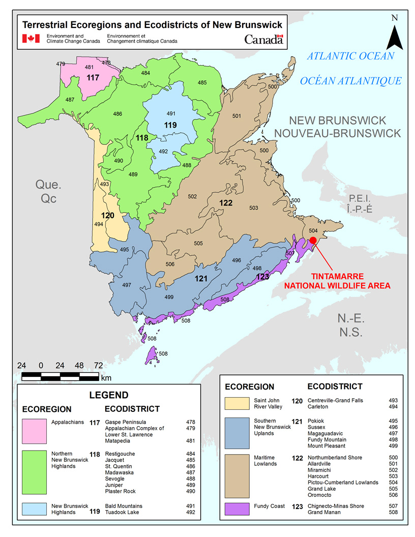
Illustration showing the terrestrial ecoregions and ecodistricts of New Brunswick and the location of Tintamarre National Wildlife Area. Seven ecoregions are shown, with Tintamarre NWA being located within Ecoregion No. 122, Maritime Lowlands. 28 ecodistricts are shown, with Tintamarre NWA being located within Ecodistrict No. 504, Pictou-Cumberland Lowlands, in the south-eastern area of the province. The scale on the map is in kilometers. The legend shows all ecoregions and ecodistricts present in New Brunswick.
1.1 Regional Context
Tintamarre NWA is located at the geographic centre of the Maritime provinces on the Chignecto Isthmus that connects New Brunswick with Nova Scotia. This location is well known for its strategic importance to migratory birds, particularly waterfowl (Boyer 1948; Erskine 1992).
Tintamarre NWA is situated within the Atlantic Maritime Ecozone. One of 15 terrestrial ecozones in Canada, the Atlantic Maritime Ecozone includes all of New Brunswick, Prince Edward Island, Nova Scotia and Quebec's Gaspé Peninsula. Within this ecozone, the NWA lies within the Maritime Lowlands Ecoregion and the Pictou-Cumberland Lowlands Ecodistrict (Figure 4). This area is characterized as low-lying with gentle rolling hills over a geology consisting predominantly of non-calcareous Pennsylvanian sandstone, conglomerate and mudstone. Throughout the 19th century, the more uniform sandstone deposits were extracted for building stone for the nearby community of Sackville.
The rich farm lands of the Tantramar Marshes are derived from centuries of tidal silts being deposited over four millennia of sea level rise and coastal subsidence. Tintamarre NWA is situated generally where these silt deposits border the uplands, resulting in low, flat lands that support a diversity of wetlands. The Tantramar is generally cooler than nearby inland sites due to its proximity to the cold waters of Cumberland Basin. The area averages 415-450 mm of precipitation during the growing season (May to September).
1.2 Historical Background
The lakes, bogs and other wetlands comprising Tintamarre NWA developed as a result of a gradual subsidence of the coastal region, combined with sea level rise, over 4000 years ago. The invading tidal waters left deposits of silt that accumulated to form salt marshes and eventually a barrier that resisted further tidal intrusion. This natural levee also impeded the drainage of water from the land, with the result that large freshwater wetlands developed immediately inland from it. Tintamarre NWA lies in the area of former interaction between seawater invasion and freshwater runoff, and includes habitats formed by both processes.
Known human history of the Tantramar area follows the development of the marsh. The earliest Aboriginal sites are over 3700 years old (MacKinnon 2003b, 2003c). The wetlands within the NWA were undoubtedly used by First Peoples as both a navigation route and for obtaining food. Although there are no known Aboriginal locations within Tintamarre NWA, there is a small site from the Middle Woodland Period, approximately 1000 years old (Borden site designation Dl-Db 19), just outside the east boundary on Jolicure Long Lake (MacKinnon 2003a).
Around 1670, the natural salt marsh processes were disrupted with the arrival of European settlers and their subsequent successful creation of arable farmland by dyking and draining tidal wetlands. Freshwater wetlands, including sites in the present NWA, were also drained and converted to farmland. Throughout the early 19th century, many of the more inland lakes and bogs were infilled with marine silts by a process known as warping or tiding (Hustvedt 1987). Hog, Rush and Goose Lakes, as well as Mud Bog, were altered in this way. To accomplish the infilling, canals were dug to allow saltwater to flood the freshwater wetlands and peatlands. These special canals can be identified on period maps as “tide feeder streams.”
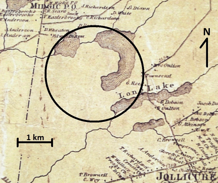
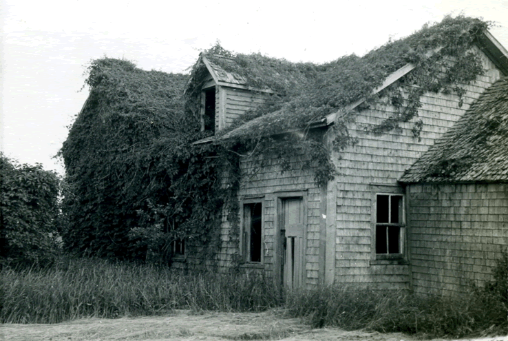
The uplands of the area were cleared for merchantable timber and farm land. Early in the 20th century, there were six homesteads situated within the boundary of the present NWA. Most of these had been abandoned for a considerable period before land acquisition in support of the establishment of Tintamarre NWA was initiated in the late 1960s (Figure 5). With changing times and the transition from horses to tractors, many of the poorly drained haylands could not easily support heavy farm machinery, and peripheral areas were not maintained. Despite renewed attempts in the 1950s and early 1960s to revive and maintain some of this land for agricultural use, much of the dykeland within the NWA lay idle.
The importance of the Tantramar dykelands to waterfowl has long been recognized, and prompted one of the first studies to look at waterfowl use of these areas by Boyer (1951). Tintamarre NWA was proposed for acquisition through the National Habitat Protection Program in 1966 (Whitman 1966). Most lands were acquired in 1972 and 1973 by fee simple purchase.
The 1900 ha were officially identified as an NWA under the Wildlife Area Regulations on 27 April 1978 by Order in Council P.C. 1978-1439.
Long description for Figure 5
Historical 1862 map depicting homesteads in the vicinity of Jollicure. Map shows Long Lake, in the centre, as well as streams. Roads and houses are shown on the map. Names of land owners are indicated on the map. Circle shows roughly the present-day Tintamarre NWA. Scale shows 1 kilometre.
1.3 Land Ownership
Tintamarre NWA is owned by the Government of Canada and administered by the Canadian Wildlife Service under the Canada Wildlife Act. The property boundary is delineated with NWA boundary signs.
The federal government does not hold the subsurface mineral rights for Tintamarre NWA.
1.4 Facilities and Infrastructure
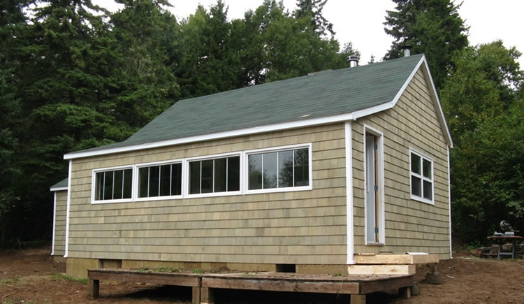
Maintenance of boundaries, entrance and regulatory signs, access roads, field accommodations, and storage facilities at Tintamarre NWA is an annual requirement (Table 2). The 30.5 km boundary is routinely inspected, and lines are cleared and signs replaced where necessary. Entrance signs are maintained at conspicuous sites: Goose Lake Road, Front Lake Landing and the entrance to the Jolicure Lakes Field Station (Figure 7). The Jolicure Lakes Field Station provides onsite accommodations, while a large barn and associated work yard provides storage space for the Atlantic Region's protected areas program (Figure 8).
Canadian Wildlife Service habitat staff and Ducks Unlimited Canada personnel conduct regular inspections of impoundments, including dykes, water control structures and water levels (Figure 9). Ducks Unlimited Canada is responsible for maintenance and repairs to the controlled water-level impoundments within the NWA.
Thirteen controlled water-level projects totalling 890 ha have been developed at Tintamarre NWA with the cooperation of Ducks Unlimited Canada (Table 3). Macro-habitat conditions within all impoundments are assessed every year based on high-resolution aerial photography (MacKinnon and Kennedy 2012). Specific site-management objectives and actions for these projects are collaboratively determined between Ducks Unlimited Canada and the Canadian Wildlife Service each year. The Canadian Wildlife Service will work with Ducks Unlimited Canada to develop an annual planning framework for the maintenance of infrastructure.
| Type of Facility or Infrastructure | Approximate Size or Number | Responsibility Holder or Owner |
|---|---|---|
| Property boundary | 30.5 km | Environment and Climate Change Canada - Canadian Wildlife Service (ECCC-CWS) |
| Boundary signs | ~600 | ECCC-CWS |
| NWA entry signs | 4 | ECCC-CWS |
| Public notice signs | 12 | ECCC-CWS |
| Steel entry gates | 6 | ECCC-CWS |
| Foot bridges | 1 | ECCC-CWS |
| Storage barn | 1 (10 m x 20 m) | ECCC-CWS |
| Field station | 1 (10 m x 5 m ) | ECCC-CWS |
| Boat house | 1 (3 m x 5 m | ECCC-CWS |
| Boat landing | 4 | ECCC-CWS |
| Parking lots | 4 | ECCC-CWS |
| Maintenance access points | 9 | ECCC-CWS |
| Impoundments | 19 | Ducks Unlimited Canada |
| Control structures | 19 | Ducks Unlimited Canada |
| Ducks Unlimited Canadas Project Number | Project Name | Year Built | Size (ha) |
|---|---|---|---|
| 6119 | Front Lake | 1967 | 417.6 |
| - | Large Lake | - | 190.0 |
| 6106 | Paunchy Lake Extension 1 | 1969 | 15.0 |
| 6106 | Paunchy Lake Extension 2 | 1969 | 9.3 |
| 6106 | Paunchy Lake Extension 3 | 1969 | 8.1 |
| - | Paunchy Lake Extension 4.3 | 2009 | 6.5 |
| 6129 | Fillmore's Hole | - | 14.6 |
| 6101 | Robinson Brook | 1971 | 172 |
| 6131 | Paunchy Lake 1 | 1969 | 15.0 |
| 6131 | Paunchy Lake 2 | 1969 | 9.3 |
| 6131 | Paunchy Lake 3 | 1969 | 8.1 |
| 6131 | Paunchy Lake 4 | 1969 | 14.0 |
| 6131 | Paunchy Lake Extension | 1971 | 10.1 |
| Total Area | - | - | 889.6 |