
Tway National Wildlife Area Management Plan, 2016: chapter 1
1 Description of the Protected Area
Tway National Wildlife Area (NWA) (Figure 1) provides important wildlife habitat and unique wildlife conservation attributes that include:
- Staging, nesting, brood-rearing or moulting habitat for approximately 140 bird species
- Access to water from the Carrot River system for moderation of water level fluctuations in wetland basins during dry periods (Figure 3)
- A network of ditches and water control structures built and operated by Ducks Unlimited Canada (DUC) that permit separate manipulations of the two wetland basins in the NWA and two additional basins outside the NWA
- Connection of the NWA within a larger DUC wetland project (Tway Lakes Project)
The Tway NWA region includes lands and waters managed by agencies such as DUC, Saskatchewan Wildlife Federation, Saskatchewan Ministry of Environment (Wildlife Habitat Protection Lands, Fish and Wildlife Development Lands) and Saskatchewan Ministry of Agriculture (Figure 4). When considered together, Tway NWA and surrounding lands and waters provide nationally significant habitat for migratory waterfowl and waterbirds, consistent with the Protected Areas Strategy (Environment Canada 2011).
Tway NWA and the surrounding DUC waterfowl habitat enhancement projects, such as the Tway Lakes Project, provide important waterfowl habitat in a landscape of intensive agricultural production and, as a result, attract a high number and variety of water birds. The network of wetlands has also prevented development of many road allowances in the vicinity, thereby maintaining relatively more intact habitat than the typical grid of cultivated lands separated by straight gravel roads. The Tway Lakes Project was initiated in 1968 and became fully operational in 1986. In assessing the Tway area for waterfowl production, DUC noted that the lack of water level control had a negative effect on productivity and that the lack of suitable upland nesting cover resulted in the under-use of wetlands for brood rearing. Thus, the primary objective of the Tway Lakes Project has been to maximize waterfowl production capability on the wetlands through water level management. The establishment of Tway NWA has contributed to this objective by securing adjacent upland habitat for management to improve the imbalance between the brood carrying capacity of the wetlands and the capability of surrounding uplands to produce enough broods. The wetland and upland habitat protected at Tway NWA contributes directly to the conservation and management objectives of the North American Waterfowl Management Plan. The frequency of monitoring and manipulation of water levels by DUC staff also demonstrates a public-private partnership between Environment and Climate Change Canada and DUC that has continued for nearly 45 years at Tway NWA.
Since the first acquisition of lands in 1971, and following official designation as a NWA under the Wildlife Area Regulations in 1978 (Table 1), a number of new legislative and policy changes have influenced site management. Waterfowl were and are the primary wildlife group of concern, but other groups of migratory birds, species at risk, and rare or unique habitats are now part of the criteria for selecting and directing management of NWAs.
| Protected Area Designation | National Wildlife Area |
|---|---|
| Province or Territory | Saskatchewan |
| Latitude and Longitude | 52°45'N, 105°25'W |
| Size | 245 ha |
| Protected Area Designation Criteria (Protected Areas Manual) | Historic: Area provides relatively undisturbed wetland and upland migratory bird habitat in an intensively cultivated region. Current: Criteria 1a) Migratory Birds - The area supports a group of species which is concentrated during the breeding and staging seasons |
| Protected Area Classification System | Category: A Conservation Value: High Management Goal: Species Habitat Conservation |
| International Union for Conservation of Nature (IUCN) Classification | Category IV - Habitat/Species Management Area |
| Order in Council Number | Order in Council P.C. 1978-1439 Amendment SOR/78-408 |
| Directory of Federal Real Property (DFRP) Number | 14441 |
| Gazetted | 1978 |
| Additional Designations | None |
| Faunistic and Floristic Importance | Migratory Bird Concentration Site - S3 Provincial Rank |
| Invasive Species | Smooth Brome (Bromus inermis), Quackgrass (Elymus repens), Kentucky Bluegrass (Poa pratensis), Sweet Clover (Melilotus sp.), Alfalfa (Medicago sativa), Canada thistle (Cirsium arvense), Perennial Sow-thistle (Sonchus arvensis) and Dandelion (Taraxacum officinale) |
| Species at Risk | The National Wildlife Area supports four species at risk under the federal Species at Risk Act: Common Nighthawk (Chordeiles minor), Northern Leopard Frog (Lithobates pipiens), Short-eared Owl (Asio flammeus) and Yellow Rail (Coturnicops noveboracensis). |
| Management Agency | Canadian Wildlife Service; collaboration with DUC |
| Public Access and Use | No facilities on site. Access to the NWA is limited to two roads from the north. Hiking, canoeing and kayaking, hunting (by foot only), photography and wildlife viewing (by foot only), berry picking (non-commercial, by foot only), and night use (without spotlight) authorized by posted notice. |
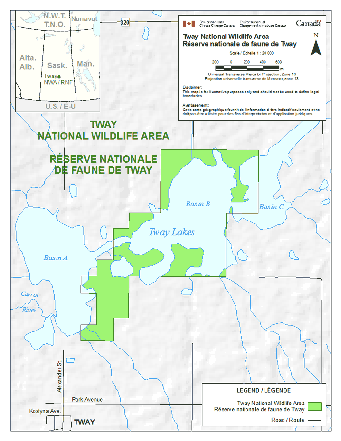
Long description for figure 1
Map showing the boundaries of Tway National Wildlife Area. Tway Lakes are located in the centre of the map and comprise three basins: Basin A, Basin B and Basin C. Basin B is almost entirely located within the NWA. The wildlife area extends from Basin C of Tway Lakes in the East to the eastern shore of Basin A of Tway Lakes in the West. Tway hamlet is located south-west of the wildlife area. North of the NWA is Road 320 and south are Alexander Street, Park Avenue, and Koslyna Avenue in Tway. The Carrot River, west of Basin A, is shown on the map. The inset map shows the location of Tway NWA in the central area of Saskatchewan, relative to the Northwest Territories, Nunavut, Alberta, Manitoba and the Unites States. The scale on the map is in meters and the Universal Transverse Mercator Projection is Zone 13. Disclaimer: This map is for illustrative purposes only and should not be used to define legal boundaries. Tway NWA and roads are indicated on the map.
1.1 Regional context
Tway NWA is a 245-ha property located 125 km northeast of Saskatoon and less than 1 km north of the hamlet of Tway, Saskatchewan. It is located in the Rural Municipality of Invergordon #430 and near the boundaries of the municipalities of Three Lakes #400 to the south and Hoodoo #401 to the west. Tway NWA straddles the Aspen Parkland Ecoregion of the Prairie Ecozone and the Boreal Transition Ecoregion of the Boreal Plain Ecozone of Saskatchewan.
Tway NWA is bisected by the Cudworth Plain Ecodistrict (Aspen Parkland) to the south and the Tiger Hills Upland Ecodistrict (Boreal Transition) to the north side of the Carrot River. Both ecodistricts are characterized by a mosaic of hummocky or undulating glaciomoraine and glaciolacustrine deposits (Acton et al. 1998). The soils are predominately Black and Dark Gray Chernozemic loams soils, and elevations range from 530 m to 610 m above sea level. The landscape immediately surrounding Tway NWA is a gravel fluviolacustrine plain. Drainage is predominantly internal to closed-basin wetlands and lakes, or the Carrot River watershed. In 2001, it was estimated that this ecodistrict contained 9% native grassland, 5% trees and shrubs, and 9% water and wetlands (Hammermeister et al. 2001). Tway NWA lies in the Carrot River Valley, which, at one time, formed the Wakaw Spillway between Glacial Lake Saskatoon and Glacial Lake Melfort (Christiansen 1979). The marshes are a series of channel wetlands of the Carrot River that have been described as open water marshes (Millar 1976). The watershed is classified as Stressed due to reduced surface and ground water quality and rangeland and riparian health issues (Saskatchewan Watershed Authority 2012a).
The regional climate is cool and subhumid, with more precipitation falling as rain during the warm summer, and relatively less precipitation falling as snow during the cold winter. Climate normals for nearby Pilger (40 km southeast of Tway NWA) indicate mean annual precipitation of approximately 320 mm, while temperatures range from a mean July high of +24°C to a mean January low of -23.5°C (Environment Canada 2014).
Agricultural land use and private land ownership dominate the region, leading to frequent changes in land cover and land use driven by changes in global demand and commodity prices. As a result, many native species and natural processes that depend upon large and stable expanses of natural land cover (i.e., migratory bison herds or wildfire) are now missing from the ecosystem. Altering the landscape also alters local drainage and may have an impact on habitat on the NWA. Prior to cultivation, surrounding upland vegetation was Fescue Prairie intermixed with Aspen Parkland communities (Coupland 1950, Coupland and Brayshaw 1953). Most of that vegetation and underlying Black Chernozemic soil was plowed and converted to cropland over the last century. Many wetlands were also drained or filled to further increase the area of arable cropland (Millar 1976, Bartzen et al. 2010).
The region is now fragmented by the grid road network that follows north-south and east-west road allowances every 1.6 to 3.2 km (McKercher and Wolfe 1978). This road network can interfere with wildlife and water movements, as well as facilitate movement of invasive alien species, pollutants, native predators and wildlife parasites (Forman et al.2003). Surrounding agricultural activities include grain and oilseed annual crop production, perennial forage crop haying, and livestock grazing. Widespread use of pesticides and fertilizers and erosion of cultivated soils has affected local water and soil quality (Donald et al. 2007, Papiernik et al. 2005, Saskatchewan Watershed Authority 2012b).
Despite these regional changes in land cover, the wetland habitats of the Tway Lakes area continue to attract a diversity of wildlife. Two species at risk and nearly 140 species of migratory birds have been observed at Tway NWA or within its vicinity.
DUC has completed nearly 3000 habitat projects in Saskatchewan, protecting 725 000 ha of wetlands and associated habitat through restoration and retention projects. The Tway NWA is embedded within the Tway Lakes Project, an initiative led by DUC. The Canadian Wildlife Service (CWS) and DUC work together closely to enhance and protect waterbird habitat in the Tway NWA.
1.2 Historical background
Prior to European settlement, the surrounding region was occupied by First Nations of Plains Cree (Nahathaway), Assiniboine (Nakota) and Saulteaux (Anishnabe) background. Through most of the 1700s and 1800s, primary land uses were trapping for the fur trade or hunting and gathering for subsistence. During this period, the fur trade directly or indirectly caused great depletions in the populations of some wildlife, like Beaver (Castor canadensis), Muskrat (Ondatra zibethicus), Bison (Bison bison) and Elk (Cervus canadensis). By the end of the 1800s, settlers began to arrive in the surrounding region (Fung 1999).
European settlers started immigrating to this area in the late 1880s, including Ukrainian and Polish immigrants to the Tway region, and Hungarian and French immigrants in the surrounding area (Yellow Creek History Committee 1982). A Canadian Pacific rail line was built between Lanigan and Prince Albert, Saskatchewan, in 1929 and abandoned in 1993. The village of Tway (currently a hamlet) was established along this rail line, providing grain elevators and other services to the local rural area. The current population of Tway is 22 people, with 12 private dwellings (Statistics Canada 2012a). In 2011, the surrounding Rural Municipality of Invergordon No. 430 had a population of 651 people in 319 private dwellings, with a median population age of 53.3 (Statistics Canada 2012b). This area has seen a large decline in population from the 1970s, but there was a 5.5% increase in population from 2006 to 2011.
From the early 1900s through to the 1970s, there was a rapid decline in natural land cover related to the increase in annual crop production. Wetlands in low relief landscapes were sometimes filled during droughts or drained to increase the area of cropland (Bartzen et al. 2010). Only where the soil was too stony, saline, sandy, saturated or steeply sloped did native grasslands and wetlands persist.
DUC initiated the Tway Lakes Project in 1968, after an initial survey of the area in 1966. The preliminary proposal involved the development of numerous wetland basins along the Carrot River, east of the outlet of Wakaw Lake. In 1970, the Tennessee Chapter of Ducks Unlimited Inc. sent a request to DUC to secure the Tway Lakes as a donor project. The request was processed, a cairn was erected on the site, and the project was named the Tennessee Tway Lakes Project. Construction of the first dyke, control structure and outlet ditch occurred in 1971, including the development of 37 artificial nesting islands.
During the 1960s and 1970s, DUC invested more in water engineering structures than in upland habitats, and thus encountered logistical challenges accessing structures across multiple private land holdings. In 1971, the CWS, under the NWA Program, purchased NW 3-44-24 W2 and the E½ NE 4-44-24 W2 to resolve this accessibility issue and increased the effectiveness of DUC's Tway Lakes Project. In 1979, DUC inspected the project, determined that the structures were inoperable and began an improvement program. From 1980 to 1982, water easement agreements were renegotiated, and new agreements were established so that objectives of the initial plan could be met (Whyte 1986). In 1983, CWS proposed to expand the NWA. The parcels of W½ and SW 3-44-24 W2, SE 4-44-24 W2, and a portion of SW 4-44-24 W2 were purchased in 1984. In 1985, NW 33-43-24 W2 was purchased (Table 2). The expansion plan included NE 32-43-24 W2, which was never secured (Whyte 1986). The most recent water control developments were completed in 1985.
Grazing management has been a desired management activity within Tway NWA, but fencing has been insufficient to contain livestock. In 2002, CWS conducted a boundary survey, and a new fence was constructed around most of the property perimeter. Grazing began thereafter for a few years until the shortcomings of the fence (incomplete perimeter, broken gates, etc.) caused permit holders to decline grazing opportunities.
1.3 Land ownership
Lands were acquired for the creation of the Tway NWA in 1971, 1984 and 1985 (Table 2). Surface title to Tway NWA belongs to the federal government. Subsurface rights are retained by the provincial government. Road allowances are owned by the provincial government but are managed by the local Rural Municipality of Invergordon No. 430. DUC has easements placed on three nearby land parcels for their water control projects.
| Legal Land Location | Title in Name Of | Exceptions | Interest Registered By | Date of Title Transfer |
|---|---|---|---|---|
| NW3-44-24 W2 | Her Majesty the Queen in the Right of Canada | N/A | Ducks Unlimited Canada | April 1971 |
| Easterly 1320 feet in perpendicular width throughout NE 4-44-24 W2 |
Her Majesty the Queen in the Right of Canada | Except most northerly 66 feet in perpendicular throughout | Her Majesty the Queen (Sask) as rep. by the Minister of Highways and Transportation | August 1971 |
| LSD 4 and 5 of 3-44-24 W2 |
Her Majesty the Queen in the Right of Canada | N/A | N/A | May 1984 |
| SE4-44-24 W2 | Her Majesty the Queen in the Right of Canada | - | Ducks Unlimited Canada | August 1984 |
| NE¼ and S½ of LSD 3 and SE¼ of LSD 6 of 4-44-24 W2 | Her Majesty the Queen in the Right of Canada | N/A | Ducks Unlimited Canada | August 1984 |
| LSD 11 and 14 and SE¼ of LSD 12 and NE¼ of LSD 13 of 33-43-24 W2 | Her Majesty the Queen (Canada) | All that portion of Legal Subdivision 11 on Plan 85PA12179 | Ducks Unlimited Canada | November 1985 |
All surrounding lands are either provincial Crown lands or are privately held by livestock and annual crop producers, many with DUC water projects on them (Figure 4).
No utility rights-of-way occur on the land base or on legal land titles.
1.4 Facilities and infrastructure
No facilities are present on site. Signs and fences are maintained by CWS through periodic field inspections along the NWA boundaries. The wood post and barbed wire perimeter fence around the NWA is 3.7 miles (7.5 km) in length and was completed in 2002 (Figure 2). Perimeter fencing is in fair to good condition, with 400 metres of fence missing on the north boundary and the west side, where the boundary goes through water and wet areas. Cross-fences on the NWA are dilapidated and require removal.
The water control infrastructure was built in 1971, repaired in the mid-1980s, and has always been operated by DUC (Figure 3). Infrastructure includes ditches, dams and culverts that DUC operates and maintains through a long-term agreement signed with CWS in 1986 (Table 3). There are no official trails on the area, but DUC staff drives on the dyke to the water control structure on the east side of the property via two-track trails extending from the north fence across the earthen dams.
From 1985 to 2015, the water control structures served their useful life. The control structure at the drainage of Tway Lake has breached, and the dyke around it has been severely eroded. Beaver activity also interferes with the function of the structures.
A concrete cairn with a brass plaque depicting and explaining the Tway Lakes Tennessee Project is maintained by DUC.

Long description for figure 2
Aerial photograph showing the location of the perimeter fencing at Tway NWA. The perimeter fencing encompasses almost completely a water body located in the centre of the photograph, extends southwest towards another water body, and stops when reaching it. Two gravel roads appear on the photograph one in the northwest corner and the other one in the southwest corner. Three dirt roads are also shown. The first reaches the fencing on its northern perimeter, the second reaches the fencing on its southern perimeter. The third dirt road appears east of the wildlife area. A small map shows the location of Tway NWA in the central area of Saskatchewan, relative to Alberta and Manitoba. The scale on the map is in meters and the Universal Transverse Mercator Projection is Zone 13N. Disclaimer: This map is for illustrative purposes only and should not be used to define legal boundaries. Tway NWA boundaries, fences, gravel roads and dirt roads are indicated on the map.
| Type of Infrastructure | Number | Condition | Approximate Size | Responsibility (Holder or Owner) |
|---|---|---|---|---|
| Artificial Nesting Islands | 5 (remaining) | Poor to Fair | 0.4 ha | DUC |
| Boundary Signs | 50 | Fair to Good | N/A | CWS |
| Ditch | 1 | Fair | 549 m | DUC |
| Drop Culvert | 1 | Poor to Fair | 4.5 m2 | DUC |
| DUC Cairn | 1 | Fair | N/A | DUC |
| Dyke and Culvert | 1 | Poor to Fair | 0.56 m x 0.92 m | - |
| Earthen Dam | 1 | Fair | 639 m2 | DUC |
| Entrance Sign | 1 | Poor | N/A | CWS |
| Information Sign | 1 | Excellent | N/A | CWS |
| Wire Gates | 6 | Fair to Good | N/A | CWS |
| Wire Fence with Wood Posts | N/A | Fair to Good | 7500 m | CWS |
| Wire Fence with Wood Posts | N/A | Dilapidated | 1700 m | CWS |
| Wire Fence with Wood Posts | N/A | Non-existent | 400 m | CWS |

Long description for figure 3
Aerial photograph showing the locations of habitat types and water control infrastructure at Tway NWA. The map shows the boundaries of the wildlife area. The NWA encompasses almost entirely an open water surrounded with wetland located in the centre of the photograph, whose eastern shore has been partly dyked. The dyke has a water control infrastructure, and a ditch starts there and runs towards the eastern boundary of the NWA. There are five artificial nesting islands located around this open water. A ditch links the open water to a lake located southwest. It ends to a dyke with a water control infrastructure. The scale on the map is in meters and the Universal Transverse Mercator Projection is Zone 13N. Disclaimer: This map is for illustrative purposes only and should not be used to define legal boundaries. Tway NWA boundaries, water control structures, dykes, ditches and artificial nesting islands are indicated on the map, as well as cover types such as: aspen and shrubs, open water, upland tame grass, wet meadow and wetland.