
COSEWIC Assessment and Status Report on the Spiked Saxifrage Micranthes spicata in Canada - 2015

Photo: Spiked Saxifrage © Syd Cannings, 2015
Long description for Figure
Photo of the Spiked Saxifrage, Micranthes spicata, in fruit, growing beside a stream. The leaves are mainly basal, with long-petioles, orbicular to reniform, and with sharply toothed and ciliated margins.
- Document Information
- Assessment Summary
- Executive Summary
- Technical Summary
- Preface
- Wildlife Species Description and Significance
- Distribution
- Habitat
- Biology
- Population Sizes and Trends
- Threats and Limiting Factors
- Protection, Status and Ranks
- Habitat Protection and Ownership
- Acknowledgements and Authorities Contacted
- Information Sources
- Biographical Summary of Report Writers
- Collections Examined
- Figure 1. Spiked Saxifrage in fruit, Spicata Creek, August 25, 2010. (Photo: Syd Cannings.)
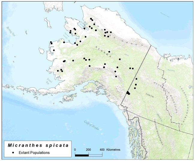
- Figure 2. Global range of Spiked Saxifrage. (Map Jenny Wu, COSEWIC Secretariat.)
- Figure 3. Potential Canadian range of Spiked Saxifrage showing the extant subpopulations and the Klondike Plateau Ecoregion. (Map: Jenny Wu, COSEWIC Secretariat.)
- Figure 4. Spicata Creek, August 26, 2010 (notice capsules). (Photo: Syd Cannings.)
- Figure 5. Spiked Saxifrage habitat at Mount Wellesley, Aug. 2013. (Photo: Shannon Stotyn.)
- Figure 6. Kate Creek. Photo In: Yukon Placer Mining Industry 2003-2006 (Photo: Yukon Geological Survey)
COSEWIC
Committee on the Status
of Endangered Wildlife
in Canada

COSEPAC
Comité sur la situation
des espèces en péril
au Cananda
COSEWIC status reports are working documents used in assigning the status of wildlife species suspected of being at risk. This report may be cited as follows:
COSEWIC. 2015. COSEWIC assessment and status report on the Spiked Saxifrage Micranthes spicata in Canada. Committee on the Status of Endangered Wildlife in Canada. Ottawa. xii + 38 pp.
COSEWIC. 2013. COSEWIC assessment and status report on the Spiked Saxifrage Micranthes spicata in Canada. Committee on the Status of Endangered Wildlife in Canada. Ottawa. ix + 35 pp.
COSEWIC would like to acknowledge Rhonda Rosie for writing the status report on the Spiked Saxifrage (Micranthes spicata) in Canada. This report was prepared under contract with Environment Canada and was overseen and edited by Bruce Bennett, Co-chair of the COSEWIC Vascular Plant Species Specialist Subcommittee.
COSEWIC Secretariat
c/o Canadian Wildlife Service
Environment Canada
Ottawa, ON
K1A 0H3
Tel.: 819-938-4125
Fax: 819-938-3984
E-mail: COSEWIC E-mail
Website: COSEWIC
Également disponible en français sous le titre Ếvaluation et Rapport de situation du COSEPAC sur le Saxifrage à épis (Micranthes spicata) au Canada.
Spiked Saxifrage -- Photo: Syd Cannings
Spiked Saxifrage is a large, showy perennial herb, growing singly or in tufts from short, thick rhizomes. The inflorescence is borne on a stalk 15-70 cm tall.
Spiked Saxifrage is an eastern Beringian endemic, one of a small group of species known globally only from unglaciated areas in Alaska and western Yukon. The Canadian population is at the eastern edge of the species’ range and has been shown to be genetically distinct from the Alaskan population. In Yukon, Spiked Saxifrage appears to occupy a narrow ecological niche, with very specific habitat conditions and a short growing season.
Spiked Saxifrage is endemic to Yukon and Alaska. In Alaska, it occurs throughout much of the central part of the state; in Canada it is known from 12 subpopulations in western Yukon. Approximately 10% of its global range is in Canada.
In Canada, Spiked Saxifrage grows in two distinct habitats, both characterized by cool, moist conditions during the growing season: the shores of cool, shady creeks, and moist, rocky alpine meadows. Along creeks, it grows on moist rock shelves of adjacent outcrops and on narrow bordering floodplains. In those places it grows in small piles of silt- and moss-covered substrate, and on exposed soil. Plants may grow singly but often form dense clusters of up to several dozen plants In moist alpine and upper subalpine, it grows among boulders and rock rubble, in turf at the edge of stabilized scree.
Creeks supporting subpopulations of Spiked Saxifrage in Yukon share a number of characteristics: year-round flow of clear, cold water in narrow, rocky beds that are subject to “glaciering” (i.e., aufeis - icethat forms in winter as spring-fed water constantly flows over the frozen creek that may persist into July) and/or permafrost, which helps to maintain a humid, cold microclimate; with rock outcrops bordering the creeks, and abundant shade from forests of Alaska Paper Birch and/or White Spruce, alders and willows.
Little is known of the biology of Spiked Saxifrage. Reproduction is by seeds and by rhizomes; conditions for germination are unknown. Self-fertilization is common in the Saxifrage family, and may occur with Spiked Saxifrage. Longevity of the plants and possible seed banks are unknown.
The plant’s ability to withstand and repopulate after disturbance is unknown. It apparently can survive flooding, but severe flood events (e.g., a flash flood) may scour the floodplain and eliminate existing subpopulations and possibly seed banks. However, plants growing on the outcrops above flood level may provide a seed source for repopulation, if essential habitat characteristics have not been altered.
Twelve subpopulations totalled 4680+ plants in 2014, of which 3244 are estimated to be mature. Though more plants are expected, it is unlikely the total will exceed 10,000.
Despite over a century of botanical collecting in the region, Spiked Saxifrage was only reported once in Canada (in 1899) until it was rediscovered in 2009, so it seems the species was uncommon or rare even during the gold rush era of the late 1800s and early 1900s. Although no population trends can be derived from data at hand, much of the species lowland habitat was likely altered or destroyed by placer mining, road-building, and wood cutting since the late 1800s. These activities are continuing. Alpine occurrences appear to be pristine.
Placer mining is the most extensive cause of habitat loss for Spiked Saxifrage in Yukon. Placer mining activity fluctuates in rate and scope with changes in gold prices. Subpopulations can be destroyed or diminished as a direct result of mining, or by upstream activities that affect habitat, such as siltation (sediment build-up), damming, stream realignment, etc. As well, natural processes such as flash flooding, forest fires, and landslides may be increasing in frequency and severity due to human-induced climate change. There are no imminent threats to the four alpine subpopulations; however habitat is limited to a small region in southwest Yukon. The effect of climate change and advanced mineral development could threaten these subpopulations in the future.
Spiked Saxifrage has a NatureServe Global rank of G3G4 (Vulnerable to Probably Secure). Its National Rank in the U.S. is N3N4 (Vulnerable to Probably Secure), and in Canada is N2 (Imperilled). Its Subnational Rank in Alaska is S3S4 (Vulnerable to Probably Secure), and in Yukon is S2 (Imperilled). The National General Status ranks for Canada and Yukon are ‘May be at Risk’.
Spiked Saxifrage currently has no legal protection in Canada, and is not listed under the U.S. Endangered Species Act or the Convention on International Trade in Endangered Species of Wild Fauna and Flora (CITES).
Active placer and/or quartz mining claims occur on or upstream of the plant’s habitat on seven of the twelve subpopulations representing about 70% of the Canadian population. While there are restrictions on how operations are conducted on those claims, these restrictions target protection of fish habitat, and there is no legal obligation to protect the habitat or existing subpopulations ofSpiked Saxifrage.
Generation time unknown, but the plants are perennial and likely do not flower for a few years after establishment. The cool shaded habitat and short growing season may suggest individual plants are very long-lived.
3+ years
Is there an [observed, inferred, or projected] continuing decline in number of mature individuals?
Yes, inferred
Estimated percent of continuing decline in total number of mature individuals within [5 years or 2 generations] (52-60 years)
Unknown[Observed, estimated, inferred, or suspected] percent [reduction or increase] in total number of mature individuals over the last [10 years, or 3 generations] (78-90 years)
Unknown
[Projected or suspected] percent [reduction or increase] in total number of mature individuals over the next [10 years, or 3 generations] (78-90 years).
Unknown
[Observed, estimated, inferred or suspected] percent [reduction or increase] in total number of mature individuals over any [10 years, or 3 generations] period, over a time period including both the past and the future.
Unknown
Are the causes of the decline clearly reversible and understood and ceased?
No
- The causes are understood and may be reversible, but have not ceased.
Are there extreme fluctuations in number of mature individuals?
No
Estimated extent of occurrence
9,622 km²
Index of area of occupancy (IAO, 2 x 2 km² grid values)
56 km²
Is the population severely fragmented? >50% of the population is in patches that are large enough to be considered viable.
NoNumber of locations
12 (12-14)Is there an observed continuing decline in extent of occurrence?
NoIs there an observed continuing decline in index of area of occupancy? (Current Area of Occupancy is 65% of historical; see Figure 4)
Unknown, but likelyIs there an inferred continuing decline in number of subpopulations? There may be a continuing decline through loss of the small subpopulations through mining activities?
YesIs there an inferred continuing decline in number of locations? There may be a continuing decline through loss of the small subpopulations through mining activities?
YesIs there an observed continuing decline in area, extent and/quality of habitat? Lowland habitat is declining through mining activities; upland may be in slow decline through shrubification.
Yes
Are there extreme fluctuations in number of populations?
NoAre there extreme fluctuations in number of locations?
NoAre there extreme fluctuations in extent of occurrence?
NoAre there extreme fluctuations in index of area of occupancy?
No
| Subpopulation | N Mature Individuals (total individuals) |
|---|---|
| Donahue Creek | 88 (132) |
| Spicata Creek | 1054 (1682) |
| Fourth Creek | 1 (6) |
| Snow Creek | ~492 (652) |
| Dry Creek | 352 (502) |
| Sanpete Creek (north fork) | ~525+ (700+) |
| Sanpete CreekFootnote star* | 0 (2) |
| Sanpete Creek (southern tributary) | ~229 (305) |
| Sanpete Hill | 87+ (130+) |
| Mount Wellesley | 159+ (238+) |
| Koidern Mountain | 24+ (36+) |
| Koidern Mountain (south ridge)Footnote star* | 0 (2) |
| Eikland Mountain | 66+ (100+) |
| Beaver Creek tributary | 167+ (250+) |
| Total | >3244 |
Probability of extinction in the wild is at least [20% within 20 years or 5 generations, or 10% within 100 years].
not done
- Present and future placer and quartz (hard rock) mining and associated human disturbance.
- Indirect effects of climate change including increasing frequency of extreme weather events, which may increase the frequency and/or severity of floods, landslides and wildfires, potential changes to habitat in subalpine and alpine areas over the long term.
- Human-caused fires.
Status of outside population(s)?
Alaska S3S4 (vulnerable to apparently secure)Is immigration known or possible? Unlikely due to long dispersal distance required.
Unknown but unlikely
Would immigrants be adapted to survive in Canada? However, Alaskan plants have been shown to be genetically different, so the existing populations may be better adapted for local conditions.
ProbablyIs there sufficient habitat for immigrants in Canada? Habitat loss is considered a key threat. However, dispersal ability to recolonize remaining suitable habitat may be limiting.
Possibly
Is rescue from outside populations likely?
No
- COSEWIC: Designated Threatened in May 2013. Status re-examined and designated Special Concern in May 2015.
Spiked Saxifrage was first assessed as Threatened by COSEWIC in May 2013. In the summer of 2013, additional sites were discovered, which increased the range and total number of known subpopulations for the species. Some of these new sites were in alpine habitat, a situation previously not known in Canada. Under Section 24 of the Species at Risk Act, COSEWIC must review the classification of a wildlife species if there is reason to believe its status might have changed. In November 2013, COSEWIC determined a reassessment of Spiked Saxifrage should take place. Targeted surveys on foot and with helicopter support in the summers of 2013 and 2014 resulted in an increase in the estimated extent of occurrence (EOO) from 7213 km² to 9,622 km², index of area of occupancy (IAO) from 24 km² to 56 km², number of locations from 6 to 12-14, and the number of mature individuals from ~2500 to ~3200. It is believed that most of the suitable habitat has now been searched although population size is likely to be larger than what has been reported.
Spiked Saxifrage’s conservation rank was reviewed by NatureServe in (2014) and remains unchanged as Imperilled in Yukon (S2) and in Canada (N2). As part of the conservation rank review, a threat calculation was done which places the species under a Medium threat.
In addition, DNA barcoding has revealed the Canadian population harbours genetic variation not detected in Alaska and as such the Yukon population contributes unique genetic diversity to the species.
The Committee on the Status of Endangered Wildlife in Canada (COSEWIC) was created in 1977 as a result of a recommendation at the Federal-Provincial Wildlife Conference held in 1976. It arose from the need for a single, official, scientifically sound, national listing of wildlife species at risk. In 1978, COSEWIC designated its first species and produced its first list of Canadian species at risk. Species designated at meetings of the full committee are added to the list. On June 5, 2003, the Species at Risk Act (SARA) was proclaimed. SARA establishes COSEWIC as an advisory body ensuring that species will continue to be assessed under a rigorous and independent scientific process.
The Committee on the Status of Endangered Wildlife in Canada (COSEWIC) assesses the national status of wild species, subspecies, varieties, or other designatable units that are considered to be at risk in Canada. Designations are made on native species for the following taxonomic groups: mammals, birds, reptiles, amphibians, fishes, arthropods, molluscs, vascular plants, mosses, and lichens.
COSEWIC comprises members from each provincial and territorial government wildlife agency, four federal entities (Canadian Wildlife Service, Parks Canada Agency, Department of Fisheries and Oceans, and the Federal Biodiversity Information Partnership, chaired by the Canadian Museum of Nature), three non-government science members and the co-chairs of the species specialist subcommittees and the Aboriginal Traditional Knowledge subcommittee. The Committee meets to consider status reports on candidate species.
The Canadian Wildlife Service, Environment Canada, provides full administrative and financial support to the COSEWIC Secretariat.
Scientific name: Micranthes spicata (D. Don) Small
Synonyms:
- Saxifraga spicata D. Don
- Saxifraga galacifolia Small
- Micranthes galacifolia (Small) Small
English common name: Spiked Saxifrage
French common name: Saxifrage en épis
Family: Saxifragaceae, Saxifrage Family
Major plant group: Angiosperm - Eudicot flowering plant
The Saxifragaceae has undergone considerable revision in the past several decades, resulting in the splitting of the genus Saxifraga into Saxifraga and Micranthes, based on molecular phylogenetic analysis (Wells and Elvander 2009). Spiked Saxifrage is the largest of the ten species of Micranthes in Yukon, and of the 20 species that occur in Alaska and northwestern Canada (Brouillet and Elvander 2009). No subspecies or varieties of Spiked Saxifrage have been described.
Spiked Saxifrage was first collected in 1822 on Sledge Island on the Seward Peninsula of Alaska by David Nelson, a botanist on Captain Cook’s third voyage, and was later described by David Don as Saxifraga spicata (Bennett and Withers 2010). The first specimens from Canada were collected in 1899, and were described as a new species, S. galacifolia Small (Britton and Rydberg 1901). However, Eric Hultén considered S. galacifolia synonymous with S. spicata (Hultén 1941).
Spiked Saxifrage (Figure 1) is a showy perennial herb, growing singly or in tufts from short, thick rhizomes. Leaves are mainly basal, with long-petioles, orbicular to reniform (kidney-shaped), covered with fine short hair or becoming hairless with age, and with sharply toothed and ciliated margins. Stem leaves, if present, are small, ovate to linear, and lack petioles. The inflorescence is borne on a stalk 15-70 cm tall, forming slender, compact, glandular-pubescent panicles. Fruits are basally connate, green and purplish-tinged capsules, 5-8 mm long. Seeds are small, brown, and longitudinally ribbed (Brouillet and Elvander 2009).
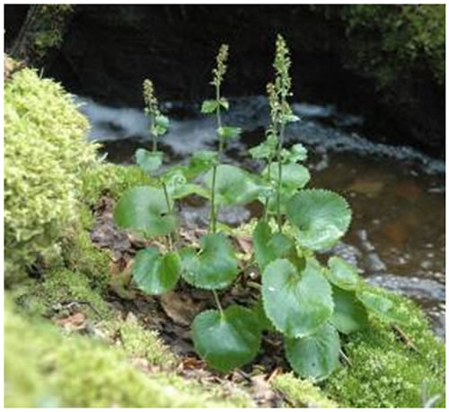
Photo: Spiked Saxifrage © Syd Cannings, 2015
Long description for Figure 1
Photo of the Spiked Saxifrage, Micranthes spicata, in fruit, growing beside a stream. The leaves are mainly basal, with long-petioles, orbicular to reniform, and with sharply toothed and ciliated margins.
The plant somewhat resembles Heart-leaved Saxifrage (Micranthes nelsoniana), which occurs in similar habitats but is overall a smaller plant than Spiked Saxifrage. Both species have round, orbicular leaves, but those of Spiked Saxifrage have more numerous teeth relative to M. nelsoniana. Flowers of M. nelsoniana have white petals 2.5-4.5 mm long, and form congested capitate or corymb-like panicles with 10+ flowers, and capsules that are 3-6 mm long, while those of Spiked Saxifrage have cream to yellowish petals 4-7 mm long, forming spikes of 15+ flowers, with capsules 5-8 mm long.
DNA barcoding uses short regions of DNA to uncover genetic differences between and within species (Saarela et al. 2013). Plants from throughout the range of Spiked Saxifrage (n=24) were surveyed at the ITS-2 region (internal transcribed spacer 2) and the results archived in the Barcode of Life Systems database (BOLD) (Ratnasingham and Hebert 2007). Neighbour-joining analysis uncovered two major clusters: one includes plants only from Yukon and the other includes plants from Yukon and Alaska. Though there was not enough evidence to support a designatable unit structure, there is evidence that the Canadian population harbours genetic variation not found in Alaska, and therefore the Yukon population contributes unique genetic diversity to the species.
Because all known subpopulations occur in the same COSEWIC ecological zone (Northern Mountain), and because the findings of genetic differences among Canadian subpopulations are preliminary, only one designatable unit is recognized.
Spiked Saxifrage is significant in being an eastern Beringian endemic, one of a small group of species known globally only from unglaciated areas in Alaska and west-central Yukon (Klondike Plateau Ecoregion). A genetic group has been identified based on DNA barcoding as unique to the Canadian population, which may be important to maintaining the genetic diversity of the species (Ratnasingham and Hebert 2007).
No traditional uses of the plant have been reported by the Tr’ondëk Hwëch’in First Nation in the Yukon range of Spiked Saxifrage (Olson pers. comm. 2011), but in Alaska the plant is reported as used as food by Alaskan Aboriginal peoples (Moerman 1998).
Spiked Saxifrage has been found only in Alaska and western Yukon Territory. In Alaska, it occurs scattered throughout much of the central part of the state from the Yukon border to the west coast (Figure 2).
Long description for Figure 2
Map of the global range of the Spiked Saxifrage, which has been found only in Alaska and western Yukon Territory. In Alaska, the species occurs scattered throughout much of the central part of the state from the Yukon border to the west coast.
Spiked Saxifrage is known in Canada from 12 subpopulations representing seven creeks and four mountains in western Yukon (Figure 3; Table 3).
Four of the creeks are tributaries to the Yukon River: Donahue Creek (the gazetted name is Donohue Creek, but local and government usage today is Donahue Creek (Yukon Tourism and Culture March 2011)), “Snow Creek” (ungazetted), “Spicata Creek” (ungazetted), and an unnamed creek which will be referred to as “Fourth Creek” in this report. Three other creeks are tributaries to the White River, itself a main tributary to the Yukon River: Beaver Creek, Dry Creek, and Sanpete Creek.
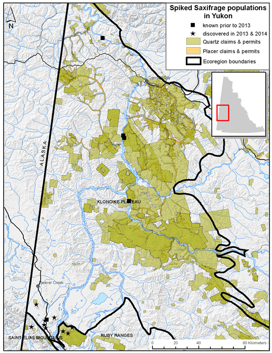
Long description for Figure 3
Map of potential Canadian range for the Spiked Saxifrage, indicating extant populations and outlining the Klondike Plateau Ecoregion.
While there are thousands of creeks of all sizes in the Klondike Plateau Ecoregion, it is unlikely that very many of them host Spiked Saxifrage, either for natural reasons (i.e., the species’ restricted/narrow ecological niche, poor dispersal abilities) or owing to human disturbance. Most of the 156 creeks checked (see Search Effort) along the Yukon River, Stewart River, and upper White River had potentially suitable habitat, i.e., similar rich species diversity and physical attributes (Kennedy pers. comm. 2011), but only 3.8% of those searched contained Spiked Saxifrage.
The seven Yukon streams occupied by Spiked Saxifrage possess similar physical characteristics, i.e., small narrow creeks, bordered by bedrock hills (Figure 4).
The four mountains, atop which Spiked Saxifrage has been found, occur in a defined area south of Beaver Creek of southwestern Yukon that experiences significantly moister summers than the rest of the central Yukon (see Habitat).
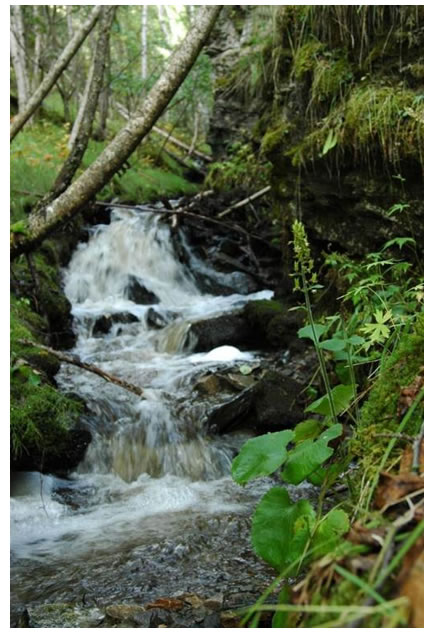
Long description for Figure 4
Photo of Spiked Saxifrage habitat at Spicata Creek, showing waterfalls, rock outcrops bordering the creek and abundant shade from forests of Alaska Paper Birch and/or White Spruce, alders and willows. Other vegetation consists of a diverse assortment of low shrubs, mosses, grasses, forbs, and abundant leaf litter.
The extent of occurrence (EOO), based on a minimum convex polygon around known extant observations, is 9,622 km². Using a 2 km x 2 km grid, the index of area of occupancy (IAO) is 56 km².
Spiked Saxifrage was first discovered in Yukon by the botanist John Berry Tarleton in 1899, during a canoe trip down the Yukon River from its headwaters to Dawson City (Tarleton 1900). He found it growing “along mountain streams” entering the Yukon River in the vicinity of the Indian River. According to his journal, this stream (or streams) was a short distance upriver of the Indian River, and is most likely Spicata Creek or Fourth Creek, which are immediately upriver of the Indian River (Bennett pers. comm. 2011; Cannings pers. comm. 2011).
Despite over a century of botanical collecting in the Territory since Tarleton’s discovery in 1899 (Table 2), and repeated efforts to locate the plant (Bennett pers. comm. 2011), this large and conspicuous plant was not seen again in Yukon until 2009 at Donahue Creek (Bennett and Withers 2010). Martha Black, a resident of Dawson during and after the gold rush, made an extensive collection of plants of the region and did not report Spiked Saxifrage (Black 1940).
Following the rediscovery of the species at Donahue Creek, intensive targeted search efforts were made to locate more sites from 2010 to 2014 by Environment Canada, Canadian Wildlife Service (CWS), Environment Yukon biologists, the Tr’ondëk Hwech’in First Nation, the report writer, and other local botanists.
In order to estimate how many subpopulations of Spiked Saxifrage may exist in western Yukon, the physical characteristics of known occurrences were used in combination with aerial photos, satellite imagery, Google Earth images, and maps of bedrock outcroppings, to attempt to identify creeks in the Klondike Plateau Ecoregion with potentially suitable habitat for Spiked Saxifrage. A total of 211 creeks in ten drainages (including the Yukon River) met these rough criteria (Table 1). However, placer mining (i.e., mining of alluvial sand and gravel deposits for minerals and gemstones) has occurred along many of these creeks and their tributaries, so it is likely that some existing or potential habitat for Spiked Saxifrage habitat has been degraded or destroyed.
| Drainage | Total Number of Tributary Streams (Using 1 To 50000 Map) | Estimate of Possibly Suitable Tributary Streams |
|---|---|---|
| Yukon River | 430 | 120 |
| Stewart River | 40 | 10 |
| White River | 150 | 25 |
| Klondike River | 54 | 5 |
| Indian River | 65 | 12 |
| Sixty Mile River | 103 | 15 |
| Forty Mile River | 18 | 8 |
| Fifty Mile River | 20 | 7 |
| Donjek River | 60 | 7 |
| North Ladue River | 60 | 2 |
| Totals | 1000 | 211 |
| Year(s) | Collector(s) | Affiliations | Locations |
|---|---|---|---|
| 1883 | Frederick Schwatka | United States Army | Yukon River |
| 1887 | George Mercer Dawson | Geological Survey of Canada | Pelly and Yukon river areas |
| 1893-4 | Frederick Funston | U.S. Department of Agriculture | Yukon River, Forty Mile Creek, Porcupine River |
| 1898-9 | Martin Woodlock Gorman | - | Yukon River between White Pass and Dawson Fort Selkirk, White River |
| 1898-ca 1955 | Martha Louise Black | - | Dawson area |
| 1898-9 | Robert Statham Williams | New York Botanical Garden | vicinity of Dawson, Klondike River |
| 1898 | Joseph Burr Tyrrell | Geological Survey of Canada | chiefly in the Dawson area, Forty Mile Creek |
| 1898-1901 | John J. McLean | U.S. Single Service | Dawson City and the Klondike Goldfields |
| 1898-1900 | Arthur L. Bolton | - | Dominion Creek, Fifty Mile River |
| 1898 | Frithiof Anderson | University of Gothenburg | Yukon River, Stewart River, Indian River, Dawson City |
| 1898 | Otto Nordenskjold | University of Gothenburg | Yukon River Stewart River, Eldorado Creek |
| 1899 | John Berry Tarleton | - | Yukon River to Dawson City |
| 1899-1900 | Wilfred H. Osgood | U.S. Biological Survey | Yukon River from source to Fort Yukon |
| 1902 | John Macoun | Geological Survey of Canada | in the Yukon Valley between Whitehorse and Dawson, Hunker Creek, Colorado Creek, Klondike River, Gold Run Creek, Klondike-Indian Divide |
| 1903 | Charles Arthur Hollick | New York Botanical Garden | Dawson |
| 1905 | E. Dossel | - | Yukon River |
| 1909 | Arthur Spear Hitchcock, Royal Shaw Kellogg | U.S. Department of Agriculture, U.S. National Forest Service | along the Yukon River between Whitehorse and Dawson |
| 1908-1917 | Donaldson Delorme Cairnes | Geological Survey of Canada | along the Alaska-Yukon border from 1908 to 1917 |
| 1914 | Alice Eastwood | Herbarium of the California Academy of Science | the upper Yukon and Dawson areas, Moosehide, Dome Creek, Swede Creek, Bonanza Creek, Coffee Creek |
| 1914 | Margaret Milvain | Californian Academy of Science | Dawson and Glacier |
| 1916 | Oscar Malte | Curator National Herbarium, Ottawa | Yukon River valley and Dawson City |
| 1918 | W.E. Cockfield | - | Stewart River, McQueston Lake |
| 1926-30 | J.B. Mertie | U.S. Geological Survey | Tatonduk to Nation Rivers, Alaska Yukon border |
| 1932 | William Albert Setchell and Clara B. Setchell | Professors of Botany, University of California | Yukon River and Dawson City |
| 1933 | Isobel Wylie Hutchison | - | Yukon River and Dawson City |
| 1933-1950 | Hugh Bostock | Geological Survey of Canada | from the Mayo and McQuesten areas and Dawson Range |
| 1936 | R.V. Moran | - | Vicinity of Dawson |
| 1949 | James A. Calder | Canada Department of Agriculture | near Dawson |
| 1984 | William Cody, James Ginns | Agriculture Canada | Dawson and northern Dawson Range |
| 1990 | Yukon Renewable Resources | Yukon Government | Vegetation survey, Dawson City east to Dempster Highway cutoff-100 plots |
| 2001 | Yukon Renewable Resources | Yukon Government | Vegetation and soil survey, eastern part of Klondike Plateau Ecoregion - 30 plots |
| 2007 | Environment Yukon | Yukon Government | Vegetation survey, along road west of Dawson and Top of the World Highway - 40 plots |
| 2009 | Environment Yukon | Yukon Government | Wetland survey, along Stewart River west to Yukon River - 31 plots (29 wetland, 2 grassland) |
| 2010 and 2012 | Rhonda Rosie | Western Copper and Gold Corporation | Rare plant survey south of Yukon River from west of Minto to Patton Hill |
| Creek | Date | Name of Surveyors | Immature | Mature | Total Count | Probable Maximum Totals | Comments | Mining | [Percentage]Footnotea |
|---|---|---|---|---|---|---|---|---|---|
| 1. Donahue Creek (EO 433) |
11-Aug-10 | Stu Withers | not recorded | not recorded | 57, but count was incomplete | 100-132 | The 2010 count was incomplete. The 2011 count was intended to begin where the 2010 count left off, but there may have been some spatial overlap. Therefore, the total population is estimated at 100-132 individual plants. Plants grew on banks along creek. | Partially within both active quartz mining claims and active placer mining claims | 1.6 |
| 1. Donahue Creek (EO 433) |
23-Jun-11 | Saleem Dar | not recorded | not recorded | 75, but count may include overlap from 2010 | 100-132 | The 2010 count was incomplete. The 2011 count was intended to begin where the 2010 count left off, but there may have been some spatial overlap. Therefore, the total population is estimated at 100-132 individual plants. Plants grew on banks along creek. | Partially within both active quartz mining claims and active placer mining claims | 1.6 |
| 2. Spicata Creek (EO 501) |
26-Aug-10 | Syd Cannings | 200-300 | 200-300 (flowering) | >500 | 1682 | The 2010 count was incomplete. The 2011 count covered the entire area of Spiked Saxifrage occurrence. Aufeis covered most of creek above the counted area. Plants grew along banks and on bordering cliffs. | Entirely within active quartz mining claims | 35.9 |
| 2. Spicata Creek (EO 501) |
25-Jun-11 | Saleem Dar | 628 | 1054 includes plants without flower buds but which appear mature otherwise | 1682 | 1682 | The 2010 count was incomplete. The 2011 count covered the entire area of Spiked Saxifrage occurrence. Aufeis covered most of creek above the counted area. Plants grew along banks and on bordering cliffs. | Entirely within active quartz mining claims | 35.9 |
| 3. Fourth Creek (EO 771) |
25-Jun-11 | Saleem Dar | ? | ? | 1 | 1 | Appears to be a survivor of former placer mining disturbance. Plant was growing on ground. | Entirely within an active placer claim and within less than 50 m of an active quartz mining claim | 0.1 |
3. Fourth Creek
|
21-July-12 | Saleem Dar | 5 | 1 | 6 | 6 | 500 m of creek was searched. The second plant was likely not detected the year before as it was not flowering. | Entirely within an active placer claim and within less than 50 m of an active quartz mining claim | 0.1 |
| 4. Snow Creek (EO 724) |
14-Sep-11 | Saleem Dar and Sebastian Jones | not recorded | not recorded | >479; count doesn’t include plants higher up on rock outcrop | >479 | All occur on the rock ledges above the creek; none on ground along creek; plants senescing. | Not currently within mining claims, but active quartz mining claims are located ~3.5km upstream | 13.9 |
| 4. Snow Creek (EO 724) |
19-Aug-12 | Sebastian Jones | not recorded | not recorded | 652 | 652 | Numerous seedlings were counted as plants. This year the top of the cliff was skirted and the patch delineated better. | - | 13.9 |
| 5. Dry Creek (EO 935) |
4-Sep-12 | Saleem Dar Syd Cannings |
150 | 352 | 502 | 502 | Plants occurred in three patches. Reaches downstream of occurrence were searched without success. | Entirely within active placer mining claims | 10.7 |
| 6. Sanpete Creek (N. Fork) (EO 934) |
11-Sep-12 | Syd Cannings Shannon Stotyn Bruce Bennett |
not recorded | not recorded | 700 | >700 | Population seems to be restricted by available habitat. Upper reaches were not searched. | •No mining •Falls partially within White River FN site specific S-186B |
15 |
| 7. Sanpete Creek (EOID 1167) (not a viable subpopulation) |
9-July-13 | Shannon Stotyn Saleem Dar |
2 | 0 | 2 | 2 | Habitat seems unsuitable. Poor viability. Though exhaustive survey has not been conducted. | •No mining •One of the points is within 65 metres of an area logged before 1990 |
0.04 |
| 8. Southern Tributary Sanpete creek (EOID 1174) |
10-July-13 | Syd Cannings Shannon Stotyn Saleem Dar |
101+ | 52+ | 305 (notes on maturity for only half the count) |
305+ | More area is available to be explored. | •No mining •A small portion falls within an industrial reservation for an NPA compressor station |
6.4 |
| 9. Sanpete Hill (EOID 1165) |
11-Aug-13 | Shannon Stotyn Saleem Dar |
Not recorded | Not recorded | 130+ | 130+ | Population probably larger and more extensive | •No mining | 2.8 |
| 10. Mount Wellesley (EOID 1163) |
11-Aug-13 | Syd Cannings Shannon Stotyn Saleem Dar |
Not recorded | Not recorded | 238+ | 238+ | Complete count not available. 5 patches spread over ~2 km. | Almost entirely within active quartz mining claims | 5.1 |
| 11. Koidern Mtn (EOID 1164) |
11-Aug-13 | Shannon Stotyn Saleem Dar |
Not recorded | Not recorded | 36+ | 36+ | More may exist in vicinity. 2 patches (16+20) | Entirely within active quartz mining claims | 0.8 |
| 12. Eikland Mtn (EOID 1166) |
12-Aug-13 | Saleem Dar | Not recorded | Not recorded | >100 | >100 | Entire population not surveyed. | •No mining | 2.1 |
| 13. Koidern Mtn (S. Ridge) (EOID 1249) (not viable) |
6-July-2014 | Syd Cannings Michael Svoboda | 2 | 0 | 2 | 2 | - | Entirely within active quartz mining claims | 0.1 |
| 14. Beaver Cr Tributary (EOID 1250) |
6-July-2014 | Syd Canning Michael Svoboda | Not recorded | Not recorded | 250+ | - | - | •Half of it falls within White River FN S-block S-176B (the creek is the boundary for the S-block and I mapped the population as occurring on both sides of the creek) •No current mining, but partially fell within quartz mining claims that expired in 2009 (the portion that is not on settlement land); active quartz mining claim is located 2.5 km upstream. |
5.3 |
| Totals | - | - | - | - | 4680 | 4935-4967 | - | - | - |
In 2013, surveys were undertaken from July to September to search for more subpopulations in other similar habitats in the headwaters of the White River (Dry Creek and Sanpete Creek). Where Spiked Saxifrage was found, subpopulation size was estimated and habitat details recorded. Twenty-four sites were searched resulting in the discovery of six new subpopulations.
In July 2014, four CWS field staff conducted four days of helicopter-based surveys at both high and low elevation sites in the Beaver Creek and White River areas. The surveys resulted in the discovery of two additional sites and it is believed that most of the suitable habitat in the area has now been searched.
In all cases, time and access constraints resulted in a) many creeks not being sampled because they appeared to have a low likelihood of supporting Spiked Saxifrage; b) some creeks not being sampled because access was difficult or time-consuming; and c) most creeks being sampled only to a point where it was judged that the habitat was not likely to support Spiked Saxifrage farther upstream.
The Alaskan population of Spiked Saxifrage occupies a greater variety of habitats than do the Canadian subpopulations found to date, based on label information from over 60 voucher specimens from about 40 sites, housed at the University of Alaska Museum of the North Herbarium (2009). Most of the Alaskan specimens occur in areas with a cold, maritime climate where the common habitats for Spiked Saxifrage range from sea level to alpine, on tussocky tundra and wetlands, ledges and crevices of rock outcrops, on scree slopes and in boulder fields, turfy alpine and subalpine sites, and along creeks. In sites closer to the Alaskan coast presence of tussocks is commonly noted.
Habitat information for specimens of Spiked Saxifrage from the Alaskan interior was reviewed to extract habitat features for the plant in terrain and climatic conditions similar to the Klondike Plateau. Five collections exist in the Alaskan interior between the Yukon border and the 151st line of longitude, and an additional five collections from the Alaska Range in southern Alaska were assessed.
In the mountainous Alaska Range in southern Alaska, nearest to the Yukon sites, only one high alpine site (1417 m) for Spiked Saxifrage is recorded, on “scree slope, snow flush meadow, occasional on gravelly scree slope”. It was also found in what appears to be a subalpine site at about 1008 m on another mountain, “confined to a limited area” in a boulder field. Two collections were made in the Toklat River valley, between 900-950 m, on a “wet hillside” and “growing in woods”.
In the Ray Mountains in interior Alaska, a collection was made at around 950 m in an alpine or subalpine “moist snowbed graminoid community”. Three other sites in the Interior (Yukon Tanana Uplands) occur on riparian “wide graminoid meadows which are often flooded”, in a “partially dried up stream bed running parallel to active channel of Coal Creek”, and in a “moist, mossy draw, under willows, 1070-1220 m”. The site closest to the Yukon border where Spiked Saxifrage has been found is along a small steep creek flowing into the Yukon River, very similar to sites where it has been found in Yukon.
From these data, it appears that high moisture levels combined with cool temperatures are the key habitat requirements for Spiked Saxifrage. Within the range of Spiked Saxifrage, these attributes are associated with shady streams and floodplains. In addition, high elevation snowbeds, scree slopes, and boulder fields are often sites of late snowmelt with moist substrates during the growing season, and that alpine habitats are also limited in Alaska.
Throughout much of its Canadian range, Spiked Saxifrage habitat is associated with shady creeks in the boreal ecozone. While there are mountain ranges within the Klondike Plateau with alpine terrain, they are much less extensive than the Alaska Range, and lie in a significantly drier climate. Hence, features such as late-lying snowbeds and moist boulder fields are less common and found mainly in the highest elevations.
In the eastern portion of its interior Alaskan range and into Canada, habitats include White Spruce (Picea glauca) and Alaska Paper Birch (Betula neoalaskana and/or B. kenaica) forests, under willows (Salix spp.) and alders (Alnus spp.). Spiked Saxifrage grows on the banks and rock shelves and on the moist ledges of adjacent outcrops along creeks, on the narrow bordering floodplain. It was observed growing in small piles of silt and moss-covered substrate, and on exposed soil. Plants may grow singly but often form dense clusters of up to several dozen plants, for >400 m upstream of the creek mouth along the Yukon River, and in similar habitat in the upper reaches of Dry and Sanpete creeks
Donahue, Snow, Dry, Sanpete, and Spicata creeks share a number of characteristics: year-round flow of clear, cold water in narrow, rocky, mainly V-shaped creek valleys subject to “glaciering” (i.e., aufeis – ice that forms in winter as spring-fed water constantly flows over the frozen creek) that may persist into July or permafrost which helps to maintain a humid, cold microclimate; rock outcrops bordering the creeks, and abundant shade from forests of Alaska Paper Birch and/or White Spruce, alders and willows. Other vegetation consists of a diverse assortment of lower shrubs, mosses, grasses, forbs, and abundant leaf litter. Small bare patches of soil and accumulations of coarse woody debris also occur along the creeks (Figure 4). The vegetation along the steep slopes bordering the creeks comprises upland forests typical of the area, as well as open grassland on dry south-facing slopes.
Fourth Creek has been disturbed by placer mining, so its original condition is not known.
The Beaver Creek area experiences significantly wetter summers than does the rest of central Yukon. To illustrate, the town of Beaver Creek receives an average of 230 mm of rain during June, July and August, whereas Dawson receives an average of only 130 mm during the same period (Environment Canada 2014). In this small area of western Yukon, alpine and subalpine meadows are relatively lush, and water, especially in the mossy crevices between rocks, is readily available. On mountaintops immediately south of Beaver Creek, Spiked Saxifrage occupies the alpine and open subalpine habitats associated with it in western Alaska: moist, rocky slopes between 1211 m and 1656 m elevation, and with a variety of aspects (Figure 5). Plants tended to establish in moist crevices among boulders and rock rubble, in turf at the edge of stabilized scree, and on moist slopes where the rocky substrate was thinly covered in vegetation (Dar pers. comm. 2014).
In an effort to more precisely characterize the habitat needs of Spiked Saxifrage, data loggers that measure air temperature and relative humidity were placed in the centre of and at the edge of patches of Spiked Saxifrage, at Donahue Creek, Spicata Creek, Mount Wellesley, and Koidern Mountain (Cannings pers. comm. 2015). Results won’t be available until later in 2015 at the earliest.
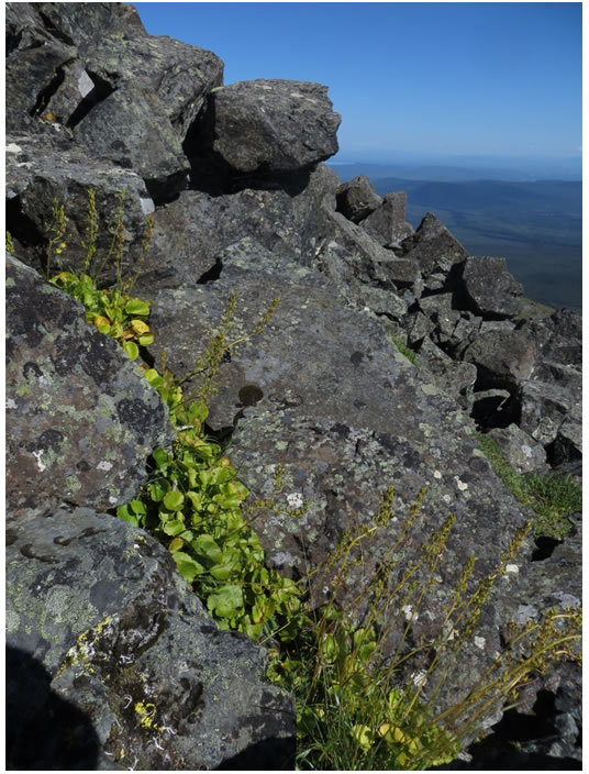
Long description for Figure 5
Photo of the Spiked Saxifrage occupying a rocky crevice in subalpine habitat at Mount Wellesle
Since the gold rush era of the late 1800s and early 1900s, the Klondike region has been heavily impacted by human activity (see also Threats and Limiting Factors). Placer mining is still active along many creeks and rivers and, along with road building, has greatly altered many drainages. The extensive quartz-mining claims (i.e., hard rock mining for gold associated with bedrock quartz veins) may also result in destructive changes to the landscape that are not confined to valleys. It is likely that much of the Canadian habitat of Spiked Saxifrage has been destroyed or degraded by placer mining during the Gold Rush era. Existing subpopulations continue to be threatened by this activity.
We can also infer that appropriate habitat (shady, cool, rocky creek banks) declined dramatically during the intense development that occurred in the area over the last 115 years. Most creeks in the broader Klondike region were at least tested for gold, and claims were registered on more than 400 creeks of all sizes (Yukon Archives 1989). Forests along the Yukon River were extensively and heavily logged for cabin and sluice box building, firewood, and fuelling river boats, and riparian forests in smaller valleys were “cut, burned, and consumed ... at an unprecedented rate” for building, heating, and for thawing permafrost in the gold-bearing gravels (Morse 2003). It thus seems likely that at least some (if not most) of the subpopulations existing at the time of early European exploration and settlement would have been adversely affected, and potential future subpopulations limited by lack of, or reduction/destruction of suitable habitat.
While large-scale forest destruction for fuel and building no longer occurs in the Klondike region, modern mechanized placer mining is inherently destructive to creek valleys (Figure 6). There is still intensive placer mining and quartz exploration activity in the region today, and we can infer that remaining habitat for Spiked Saxifrage will continue to decline if mitigation measures are not implemented.
There are fourteen known extant sites for Spiked Saxifrage (Table 3). At Donahue Creek Spiked Saxifrage plants were all found within 2 m of the creek edges (Cannings 2010). The creek shows evidence of old placer mining, but it appears the work was done by hand mining, and the creek may not have been redirected. One old placer pit at Donahue Creek occurs along the stream bank, and in 2011 Spiked Saxifrage was observed above and below the pit area but was noticeably absent along the banks at the pit. It is likely that the plant was present when mining began and, although it probably declined during the mining, was able to persist in the drainage.
Spicata Creek is much smaller than Donahue Creek, being about 2 km long and about 1-2 m wide near its mouth (Figure 4). It flows through a narrow, relatively steep gully, with many small rock cliffs on the south side of the creek. No sign of human activity in the area searched along the creek is apparent, except for a small pit in the rocky sediments at its mouth.
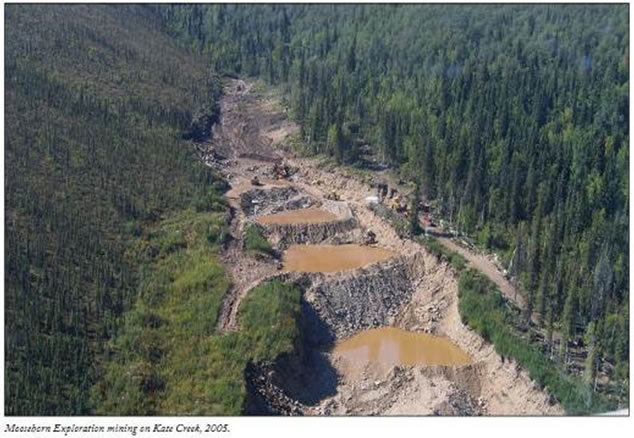
Long description for Figure 6
Photo of disturbance to Kate Creek caused by placer mining. The image shows a series of dams and ponds and ground denuded of vegetation.
Fourth Creek has been severely disturbed by recent placer mining in its lower reaches, including torn-up earth and a human-constructed dam and pond. Floods, either natural or anthropogenic, have scoured the creek bed, and its edges appear “sheared off”, with exposed roots and much less species diversity than the other three creeks (Kennedy pers. comm. 2011). In 2012, the creek was searched up to 500 m and two clumps of plants were found. These plants may have been part of a larger subpopulation that was eliminated directly or indirectly by placer mining (Dar pers. comm. 2012).
Snow Creek is about 5 km long and flows through a steep, rocky valley. Spiked Saxifrage was found along the creek and on adjacent west-facing outcrops. There was no sign of human disturbance or recent flooding (Jones pers. comm. 2011).
Dry Creek and Sanpete Creek both drain the north and west slopes of several small hills, the tallest being Sanpete Hill at 1538 m. The upper reaches consist of steep (>30°) slopes and the lower reaches meander through Black Spruce (Picea mariana) peat bogs and sedge fens. Spiked Saxifrage was found in a section of the creeks reminiscent of the previously described sites. Both sites are relatively intact, though a very old cabin exists at the lower end of Sanpete Creek.
The alpine subpopulations have shown little evidence of habitat change to date; however, subpopulations at Mount Wellesley and Koidern Mountain are in areas subject to mining exploration activities.
Little is known of the biology of Spiked Saxifrage.The following information has been obtained from reports, observations, and Malcolm McGregor’s book on saxifrages (McGregor 2008).
Reproduction in Spiked Saxifrageis by seeds and by rhizomes. In 2012, Dar (pers. comm. 2012) observed “a very thick scaly rhizome that appeared to have multiple shoots arising from it” with “another ramet coming off the rhizome 4-7 cm from the main plant”, and “some ramets appeared to come off of the rhizome even further away from the main plant (~ 15 cm)”. Closer examination of the rhizomes at Sanpete Creek showed the presence of roots on the rhizome branches, which suggest that if a crown was detached it could potentially survive independently and as such a mature individual was defined as a rosette of leaves with a flowering stalk. As such, many of the mature individuals are ramets with likely many fewer genetic individuals.
Pollinators have not been identified, but likely include a variety of flies (muscids, syrphids, etc.; Carlson pers. comm. 2011). Dar (pers. comm. 2012) reported observing pollination by a syrphid fly (likely a species of Melangyna) and a bumblebee (probably Bombus mixtus) at Spicata Creek in 2012. Indirect and circumstantial evidence suggests that most species of Micranthes are wholly or partly self-compatible, and that a few are regularly self-fertilizing (although seed set may not be as abundant as when pollinated, McGregor 2008). Spiked Saxifrage is therefore likely capable of self-fertilization.
Due to the distance between subpopulations, it is unlikely that any pollen transfer occurs between them, except for perhaps Dry and Sanpete creeks.
Conditions for germination of this species are unknown, but McGregor (2008) says that in cultivation, germination of “most of the Alaska Micranthes tends to be difficult.”
In early June, plants were just emerging, small basal leaves were present, and flowering stalks were small or absent (Cannings pers. comm. 2011). In late June, most, if not all flowers were still in bud or flowering stalks had not yet emerged, and in late August many capsules were well-developed (Cannings 2010). Photos taken at Snow Creek on September 14, 2011, show plants in senescence, with many leaves limp and browning, and many capsules fallen from the spikes (Jones 2011).
While Spiked Saxifrage is a perennial herb, the longevity of individual plants is unknown. Three years is a minimum estimate of age of maturity. The actual generation time may prove to be much greater. Based on personal experience in growing Saxifragaceae (but not including Spiked Saxifrage), McGregor (pers. comm. 2012) speculates that “It would seem that a plant such as M. spicata probably lives for up to a decade at least.” There is no information on the existence, viability or longevity of seedbanks of this species. Regarding seedbank longevity of Spiked Saxifrage in the wild McGregor believes that “Arctic seed may be long-lived in a seedbank because it is probably well-adapted to lengthy periods of freezing naturally” (pers. comm. 2012).
Spiked Saxifrage in Canada appears to be adapted to a narrow ecological niche characterized by a cold, humid microclimate, low light levels, a short growing season, and a variety of substrates (wet soil, rock crevices and ledges, woody debris).
Its ability to withstand and repopulate after disturbance is unknown. It apparently can survive at least some flooding (see also Threats), and the presence of rhizomes, and potentially seeds, may aid the plant in surviving substrate disturbance.
Seed dispersal by Spiked Saxifrage is likely similar to other saxifrages, i.e. the seed falls from the capsules when ripe and stems are shaken by wind (Webb and Gornall 1989). Seeds and possibly rhizome fragments may be dispersed further by flowing water, humans, and other animals. However, the seeds have no apparent specialized adaptations to aid in dispersal (e.g., hooks, reticulations, pappus).
Seed dispersal by Spiked Saxifrage is likely similar to other saxifrages, i.e. the seed falls from the capsules when ripe and stems are shaken by wind (Webb and Gornall 1989). Seeds and possibly rhizome fragments may be dispersed further by flowing water, humans, and other animals. However, the seeds have no apparent specialized adaptations to aid in dispersal (e.g., hooks, reticulations, pappus).
As the locality of the first collection made by Tarleton was known to be along the Yukon River between the Sixty Mile and Indian rivers, initial surveys targeted habitats in this general region, expanding into additional drainages as the most likely habitats were eliminated.
In 2010, the subpopulation at Donahue Creek was estimated at 57 mature individuals (i.e., a rosette of leaves with a flowering stalk). A more extensive survey in 2011 resulted in an estimated total subpopulation of 100-132 plants. Flowering stalks were not recorded.
In 2010, the subpopulation at Spicata Creek was estimated at >500 individuals, with 200-300 fruiting (and therefore counted as mature). In 2011, a more intensive survey resulted in a total count of 1682 plants, with 1054 mature and 628 immature.
In 2011, there was only one plant observed at Fourth Creek, and it was mature. In 2012, the creek was revisited and searched more thoroughly to 500 m. Two clumps of overlooked plants were found consisting of 6 individuals, one of which was flowering (Dar pers. comm. 2012).
In 2011, the population at Snow Creek was estimated at >479 individuals, but it was not possible to reach all parts of the outcrop on which they grew for a complete count. As well, many plants were in advanced senescence and some may have been missed during the count. Number of flowering stalks was not recorded. In 2012, a more complete count of the plants was done earlier in the season while plants were still in good condition. There were numerous seedlings included in the count. In total 652 plants were counted. In 2012, the top of the cliff was skirted and the subpopulation was better delineated.
In September 2012, two previously undetected subpopulations were discovered on Dry Creek and Sanpete Creek--two creeks that share the same headwater slope. A total of 502 individual plants in three separate patches were counted on Dry Creek, of which 352 were flowering and considered mature. The subpopulation on Sanpete Creek consisted of a single continuous patch (largest breaks in the subpopulation were <10 m) that totalled 700 plants (actual count, not an estimate). However, this is considered to be a low estimate as the subpopulation was not completely delimited and, due to the lateness of the season, many smaller immature plants may have been missed.
In 2013-2014, targeted surveys discovered eight additional subpopulations. Each of these sites has only been surveyed once (Table 3).
The total number of individual plants known in Canada as of 2014 is estimated at >4680 (Table 3) with mature (flowering or fruiting) individuals estimated to be approximately >3244. Though more plants are expected, it is unlikely the total will exceed 10,000.
Fluctuations of an order of magnitude are not known in Saxifrages and are not expected to be occurring in Spiked Saxifrage. Population trends are also unknown.
It is impossible to know how many subpopulations of Spiked Saxifrage existed in the past: the species seems to have been uncommon or rare even during the gold rush around the turn of the 20th century.
The nearest two known Alaskan subpopulations of Spiked Saxifrage are 161 and 177 km (direct line) to the northwest of the closest subpopulation in Canada (Snow Creek). Repopulation from those sources is unlikely, as seed dispersal seems very unlikely to occur over such distances or against the current of the Yukon River.
Mining and the effects of climate change have been identified as the greatest threats to Spiked Saxifrage. Habitats and subpopulations can be directly affected by mining activities. Lowland subpopulations can be impacted by upstream natural or anthropogenic events such as flooding, landslides, siltation, damming, stream realignment, and any activities that affect the water flow. Alpine habitats are less susceptible to flooding events; however, changes in moisture and habitat as a result of climate change are considered a long-term threat. A threat assessment calculated an overall threat impact of Medium-Low (Appendix 1).
As previously noted (Habitat Trends), placer mining has very likely been the most extensive and destructive cause of habitat loss historically for Spiked Saxifrage, and this continues today. Placer mining is active on creeks containing three subpopulations. Five subpopulations are under quartz claims; however, little activity is occurring at present with many in early stages of exploration. Of the Canadian population 54.3% of mature plants are on active claims and 19.2% adjacent (downstream) to active claims.
Placer gold is found in gravels along creeks and in the adjacent terraces and lower hill slopes. Placer mining has occurred in western Yukon from after the mid-1800s to the present, with especially intensive activity during the Klondike Gold Rush at the turn of the 20th century. Placer mining activity fluctuates in rate and scope as gold prices fluctuate. Exploration and staking recently have shown an increase in rate and scope as a result of the dramatic rise in the price of gold. With the recent discovery of large gold deposits in bedrock quartz veins in the Klondike region, vast areas have been staked for hard rock exploration and mining (Figure 3). In 2011 alone, 110,000 quartz claims (each 20 ha [51 acres]) were staked, almost double the last record set the year before. Though the majority of these will never be mined, there are now 250,000 such claims in Yukon, many of which are concentrated in the Klondike region.
The earliest placer mining was carried out using hand tools and improvised machinery. Eventually hydraulic hoses, dredges, and bulldozers came into common use (Gilbert 1989). Such large equipment can rapidly move vast quantities of material, and whole valleys have been dug up, often more than once, as the gravels have been reworked to extract more gold. These practices result in the complete removal of pre-existing vegetation, redirection, damming or infilling of streams, and slope thawing and removal by blasting with hydraulic hoses (Figure 6).
On creeks where mining has ceased for decades, vegetation has re-established in the valleys to varying degrees. Except for the presence of second-growth forest, landscapes may appear relatively undisturbed except for the occasional decaying cabin, cart track, cut logs, shafts, and so on. Many larger and more recent placer operations are either still being mined, or have been left to revegetate naturally. In some cases, the gravel piles have been recontoured and covered with overburden (excavated material), but the vegetation is still in early seral phases of young trees, shrubs, and grasses and forbs, and there is no habitat present considered suitable forSpiked Saxifrage.
While quartz exploration and mining may not affect creeks as extensively as placer mining, potential for riparian habitat degradation exists due to road building, toxic spills, and creation of tailings ponds (Yukon Chamber of Mines 2010).
As of 2011, active placer and quartz mining claims occur on Spiked Saxifrage habitat on Donahue, Dry, and Fourth creeks. Active quartz mining claims occur on Spicata and Snow creeks, but there are no active placer claims. There is evidence of one historical, small placer pit beside the creek’s mouth on Spicata Creek, downstream of the plant’s occurrence (Cannings pers. comm. 2011). There are no active placer claims or obvious historical mining sign at Snow Creek (Jones 2011) or Sanpete Creek (Bennett pers. comm. 2012). Of the four mountain subpopulations, Mount Wellesley is almost entirely with active mining claims and Koidern Mountain is entirely within active mining claims. Sanpete Hill and Eikland Mountain are currently not claimed; however, all subpopulations are within areas that are available to be mined (i.e., none falls within areas withdrawn from mining) and where there continues to be a lot of mining interest.
Natural habitat disturbances that can adversely affect Spiked Saxifrage include flooding, wildfire, and landslides. Flooding may be seasonal or from flash floods following heavy rainfall, which may uproot plants or possibly even eliminate an entire subpopulation. While flash floods in the Klondike Plateau Ecoregion are probably not common occurrences (Lipovsky pers. comm. 2012), some stream valleys have sustained intensive flooding and creekbed scouring, possibly as a result of heavy summer thunderstorms (Cannings 2010). Wildfires are common in the Klondike Plateau Ecoregion (Smith et al. 2004), and can adversely affect microclimate and other critical habitat factors if overstory vegetation along creeks supporting Spiked Saxifrage is burnt. Fire intensity and frequency across arctic and boreal regions is expected to increase over the next century as climate change lengthens the fire season (Stocks et al. 1998; Higuera et al. 2009; Johnstone et al. 2010). Loss of vegetation due to fire on slopes bordering creeks may cause increased thawing of permafrost, which may result in landslides (Lipovsky et al. 2006), which in turn may cause flooding, dam or alter creek flow, increase siltation load, or directly destroy subpopulations of Spiked Saxifrage.
Climate change models predict that the annual mean temperature in the west-central Yukon will increase 2.5°C to 3.5°C from 1990 to 2050, and precipitation will increase 20-30% (Werner et al. 2009). Not only is Spiked Saxifrage a species associated with very cool microhabitats that may be impacted directly by this climate change, but increased temperatures may be correlated with an increase of extreme weather events and increased incidence of wildfires, both of which are potential threats to the species. In addition, the moist mountain habitats currently occupied by Spiked Saxifrage are under the threat of habitat shift resulting from climate change, which is predicted to gradually transform mountain plant communities (e.g., Myers-Smith 2011; Myers-Smith et al. 2011; Dullinger 2012; Gottried et al. 2012) potentially making this limited habitat less viable over the long term. Abrupt shifts in forest cover are expected in response to changing climate and fire regime, particularly at sites linked to moisture availability (Stocks et al. 1998; Higuera et al. 2009; Johnstone et al. 2010).
As the threats discussed above could rapidly affect all individuals within each stream system, but as no threats are likely to affect multiple subpopulations, each subpopulation is considered to be a location as defined by COSEWIC. Each of the alpine subpopulations (i.e., Sanpete Hill, Mt. Wellesley, Koidern Mtn., Eikland Mtn.) is considered a separate location based on the threat of mining. The two subpopulations on Koidern Mountain (10 & 12) are considered to be the same location as they are both within the same group of mining claims. This reasoning results in a total of 13 locations, one of which (Sanpete Creek) is not considered viable.
Spiked Saxifrage currently has no legal protection in Canada, and is not listed under the U.S. Endangered Species Act or the Convention on International Trade in Endangered Species of Wild Fauna and Flora (CITES).
Spiked Saxifrage has a NatureServe Global rank of G3G4 (Vulnerable to Probably Secure) as of January 21, 2000, with the comment: “Known from more than sixty locations [sites] over a broad area; one site in westernmost Yukon Territory. Additional sites are expected and will likely push this rank to G4” (NatureServe 2014). Its National Rank in the U.S. is N3N4 (Vulnerable to Probably Secure), and in Canada is N2 (Imperilled). Its Subnational Rank in Alaska is S3S4 (Vulnerable to Probably Secure), and in Yukon is S2 (Imperilled, last assessed August 2014).
The National General Status ranks for Canada and Yukon are both 2: “May be at Risk” (Wild Species 2010).
All but two Canadian Spiked Saxifrage subpopulations are on Commissioner’s (i.e., Crown) Land under Yukon Territorial jurisdiction, as is most or all the area that has been claimed for placer and quartz mining. Portions of two subpopulations (Beaver Creek, and Sanpete Creek north fork) are under interim protection for the purpose of a potential land claim settlement with White River First Nation.
While there are restrictions on how operations are conducted on mining claims, these are mainly for the protection of fish habitat under the federal Fisheries Act, and there is no legal obligation to protect the habitat or existing subpopulations ofSpiked Saxifrage.
Applicants for Yukon placer mining claims must submit an application to the quasi-judicial Yukon Water Board describing their proposed mining operation, and must obtain a water use licence (Yukon Placer Secretariat 2010b).
The Department of Fisheries and Oceans Canada (DFO), designates each creek as to its suitability for salmonid habitat, and restrictions on placer mining operations and sediment discharge allowable for each level of suitability must be adhered to. Depending on the designation for a creek, restrictions are placed on allowable discharge of sediment concentrations above background levels, work within 30 metres from the high water mark, construction of new fords, construction of diversion channels, and in-stream works, except where site-specific authorization has been obtained (Yukon Placer Secretariat 2010a).
Habitat of the lower 500 m of Donahue Creek has been designated as Moderate to High Habitat Suitability (for salmonids) and above 500 m the creek is designated as Low Habitat Suitability. The provisions made to protect the salmon habitat should also afford Spiked Saxifrage habitat some measure of protection. As part of the licensing process, recommendations for protective measures for Spiked Saxifrage at Donahue Creek were made by Environment Canada and the Yukon Department of Environment (Environment Canada 2010; Yukon Environment 2010), but these conditions were not included in the licence ultimately issued by the Yukon Water Board.
Spiked Saxifrage is not known to occur in any park or protected area in Yukon.
The writer would like to thank Bruce Bennett, Syd Cannings, and Saleem Dar for their invaluable advice and input, and all others listed below for information and other help they generously provided.
| Name | Title | Affiliation | City | Province/Territory |
|---|---|---|---|---|
| Bruce Bennett | Coordinator | Yukon Conservation Data Centre, Environment Yukon; Co-Chair, COSEWIC Vascular Plant Subcommittee | Whitehorse | Yukon |
| Luc Brouillet | Professor and Curator of the Marie-Victorin Herbarium | University of Montréal | Montréal | Quebec |
| Greg Brunner | Botanist | n/a | Dawson City | Yukon |
| Syd Cannings | Species at Risk Biologist | Canadian Wildlife Service | Whitehorse | Yukon |
| Matthew Carlson | Program Botanist | Alaska Natural Heritage Program | Anchorage | Alaska |
| Saleem Dar | Species at Risk Biologist | Canadian Wildlife Service | Whitehorse | Yukon |
| Jennifer Doubt | Chief Collection Manager - Botany | Canadian Museum of Nature | Ottawa | Ontario |
| David Fraser | Scientific Authority Assessment | Ecosystems Protection and Sustainability Branch, Species and Ecosystems at Risk Section, Ministry of Environment, Government of British Columbia | Victoria | British Columbia |
| Steffi Ickert-Bond | Curator | Museum of the North, University of Alaska | Fairbanks | Alaska |
| Joelle Janes | Licensing Officer | Yukon Water Board | Whitehorse | Yukon |
| Neil Jones | Scientific Project Officer and ATK Coordinator, COSEWIC Secretariat | COSEWIC Secretariat, Canadian Wildlife Service | Ottawa | Ontario |
| Sebastian Jones | Consultant | Independent | Dawson City | Yukon |
| Thomas Jung | Senior Wildlife Biologist | Fish and Wildlife Branch, Environment Yukon | Whitehorse | Yukon |
| Catherine Kennedy | Vegetation Ecologist | Habitat Programs, Environment Yukon | Whitehorse | Yukon |
| Panya Lipovsky | Surficial Geologist | Yukon Geological Survey | Whitehorse | Yukon |
| Val Loewen, | Habitat Inventory Coordinator | Environment Yukon | Whitehorse | Yukon |
| Nathan Millar (email answered by Oliver Barker for Nathan Millar) | Senior Fisheries Biologist | Fish and Wildlife Branch, Department of Environment | Whitehorse | Yukon |
| Rhonda Millikin | A/Head Population Assessment | Pacific Wildlife Research Centre, Canadian Wildlife Service | Delta | British Columbia |
| Randi Mulder | Biodiversity Information Specialist | Fish and Wildlife Branch, Environment Yukon |
Whitehorse | Yukon |
| David Murray | Professor Emeritus | Museum of the North, University of Alaska | Fairbanks | Alaska |
| Patrick Nantel | Conservation Biologist, Species at Risk Program | Parks Canada | Hull | Quebec |
| Jackie Olson | Director, Heritage Department | T’’rondëk Hwëchin First Nation | Dawson City | Yukon |
| Carolyn Parker | Research Professional | Museum of the North, University of Alaska | Fairbanks | Alaska |
| Tim Smith | Manager, Mining Lands and Chief Mining Land Use | Yukon Energy, Mines, and Resources | Whitehorse | Yukon |
| Shannon Stotyn | Species at Risk Biologist | Canadian Wildlife Service | Whitehorse | Yukon |
| Robert Thomson | Director, Client Services and Inspections Branch | Department of Energy, Mines and Resources | Whitehorse | Yukon |
| Karen Timm | Scientific Project Officer | COSEWIC Secretariat, Canadian Wildlife Service | Ottawa | Ontario |
| Graham Van Tighem | Executive Director | Yukon Fish and Wildlife Management Board | Whitehorse | Yukon |
| Jenny Wu | Scientific Project Officer | COSEWIC Secretariat, Canadian Wildlife Service | Ottawa | Ontario |
Bennett, B.A., pers. comm. 2011. Email correspondence to R. Rosie. October-November, 2011. Coordinator, Yukon Conservation Data Centre, Whitehorse, Yukon.
Bennett, B.A., pers. comm. 2012. Email correspondence to R. Rosie. September -October, 2012. Coordinator, Yukon Conservation Data Centre, Whitehorse, Yukon.
Bennett, B.A., and S. Withers. 2010. Spiked Saxifrage, Saxifraga spicata, rediscovered in Canada after 110 years. Canadian Field-Naturalist 124(1): 57–58.
Black, M.L. 1940. Yukon Wild Flowers. Price Templeton. Vancouver, BC. 95 pp.
Britton, N.L., and P.A. Rydberg. 1901. Contributions to the botany of the Yukon Territory. 4. An enumeration of the flowering plants collected by R. S.Williams and J. B. Tarleton. Bulletin of the New York Botanical Garden 2. 149-187.
Brouillet, L., and P.E. Elvander. 2009. Micranthes. In: Flora of North America Editorial Committee, eds. 1993+. Flora of North America North of Mexico. 12+ vols. New York and Oxford. Vol. 8, p. 57.
Brunner, G., pers. comm. 2011. Email correspondence to R. Rosie. September 25, 2011. Botanist/consultant, Dawson City, Yukon.
Cannings, S. 2010. Canadian Wildlife Service Field Survey for Spiked Saxifrage (Saxifraga spicata D. Don). Environment Canada, Canadian Wildlife Service, Whitehorse, Y.T. October 4, 2010.
Cannings, S., pers. comm. 2011. Email correspondence to R. Rosie September-November, 2011. Biologist, Species at Risk Program, Canadian Wildlife Service, Whitehorse, Yukon.
Cannings, S., pers. comm. 2015. Email correspondence to B. Bennett January 29, 2015. Biologist, Species at Risk Program, Canadian Wildlife Service, Whitehorse, Yukon.
Carlson, M., pers. comm. 2011. Email correspondence to R. Rosie. November 3, 2011. Associate Professor – Biology & Program, Botanist, Biological Sciences Department, Alaska Natural Heritage Program, University of Alaska, Anchorage.
Cody, W.J. 1996. Flora of the Yukon Territory. NRC Research Press, Ottawa, Ontario, Canada.643 pp.
Dar, Saleem, pers. comm. 2011. Email correspondence to R. Rosie. November 30, 2011. Biologist, Canadian Wildlife Service, Whitehorse, Yukon.
Dar, Saleem, pers. comm. 2012. Email correspondence to R. Rosie. July 26, 2012 and August 31, 2012. Biologist, Canadian Wildlife Service, Whitehorse, Yukon.
Dar, Saleem, pers. comm. 2014. Email correspondence to B. Bennett. August 10, 2014. Biologist, Canadian Wildlife Service, Whitehorse, Yukon.
Dullinger, S., A. Gattringer, W. Thuiller, T. Moser, N.E. Zimmermann, A. Guisan, W. Willner, C. Plutzar, M. Leitner, T. Mang, M. Caccianiga, T. Dirnböck, S. Ertl, A. Fischer, J. Lenoir, J.-C. Svenning, A. Psomas, D.R. Schmatz, U. Silc, P. Vittoz, and L. Hülber. 2012. Extinction debt of high-mountain plants under twenty-first-century climate change. Nature Climate Change. 2: 619-622
Environment Canada, October 12, 2010. Letter to Yukon Water Board. Interventions document 5-4. Yukon Water Board website [Accessed March 2011].
Environment Canada. 2014. Canadian Climate Normals. [Accessed 7 October 2014].
Fast Track Land Management, October 20, 2010. Letter to Yukon Water Board. Interventions document 6.1. Yukon Water Board website: [Accessed March 2011].
Gilbert, G.W. 1989. A brief history of placer mining in the Yukon. Department of Indian Affairs and Northern Development, Whitehorse, Yukon.
Gottfried, M., H. Pauli, A. Futschik, M. Akhalkatsi, P. Barančok, J.L. Benito Alonso, et al. 2012. Continent-wide response of mountain vegetation to climate change. Nature Climate Change, 2:111-115.
Higuera, P.E., L.B. Brubaker, P.M. Anderson, F.S. Hu, and T.A. Brown. 2009. Vegetation mediated the impacts of postglacial climate change on fire regimes in the south-central Brooks Range, Alaska. Ecological Monographs, 79(2): 201–219
Hultén, E. 1940. History of botanical exploration in Alaska and Yukon territories from the time of the discovery to 1940. Botaniska Notiser. 1940: 289-346
Hultén, E. 1941-1950. Flora of Alaska and Yukon, 1-10. Lunds Universitets Arsskrift N.F., Aud. 2. Volumes 37-46. 1902 pp.
Johnstone, J.F., F.S. Chapin III, T.N. Hollingsworth, M.C. Mack, V. Romanovsky, and M. Turetsky. 2010. Fire, climate change, and forest resilience in interior Alaska. Canadian Journal of Forest Research 40:1302-1312.
Jones, S. 2011. 2011 Tr’ondëk Hwëch’in Spiked Saxifrage Project-Field Coordinators Report. Prepared for Tr’ondëk Hwëch’in Heritage Department, Dawson City, Yukon, October 2011.
Jones, Sebastian, pers. comm. 2011. Email correspondence to R. Rosie. October, 2011. Environmental consultant, Dawson City, Yukon.
Kennedy, C., pers. comm. 2011. Email correspondence to R. Rosie. October-November 2011. Vegetation Ecologist, Habitat Programs, Yukon Environment; Whitehorse, Yukon.
Lipovsky, P., pers. comm. 2012. Email correspondence to R. Rosie. March 29, 2012. Surficial Geologist, Yukon Geological Survey, Whitehorse, Yukon.
Lipovsky, P.S., J. Coates, A.G. Lewkowicz, and E. Trochim. 2006. Active-layer detachments following the summer 2004 forest fires near Dawson City, Yukon. In: Yukon Exploration and Geology 2005, D.S. Emond, L.H. Weston, G.D. Bradshaw and L.L. Lewis (eds.), Yukon Geological Survey.
McGregor, M. 2008. Saxifrages - A Definitive Guide to the 2000 Species, Hybrids & Cultivars. Timber Press, Portland, Oregon.
McGregor, M., pers. comm. 2012. Email correspondence to R. Rosie. August 30, 2012. Expert on Saxifragaceae, East Yorkshire, United Kingdom.
Moerman, D.E. 1998. Native American Ethnobotany. Timber Press, Portland, Oregon.
Morse, Kathryn. 2003. The Nature of Gold: An Environmental History of the Klondike Gold Rush. Seattle: University of Washington Press. xvii + 290 pp.
Myers-Smith, I. H. 2011. Shrub encroachment in arctic and alpine tundra: patterns of expansion and ecosystem impacts. Ph.D. Thesis, University of Alberta, Edmonton, AB.
Myers-Smith, I.H., B.C. Forbes, M. Wilmking, M. Hallinger, T. Lantz, D. Blok, K.D. Tape, M. Macias-Fauria, U. Sass-Klaassen, E. Levesque, S. Boudreau, P. Ropars, L. Hermanutz, A. Trant, L. Siegwart Collier, S. Weijers, J. Rozema, S.A. Rayback, N.M. Schmidt, G. Schaepman-Strub, S. Wipf, C. Rixen, C.B. Menard, S. Venn, S. Goetz, L. Andreau-Hayles, S. Elmendorf, V. Ravolainen, J. Welker, P. Grogan, H.E. Epstein, and D.S. Hik. 2011. Shrub expansion in tundra ecosystems: dynamics, impacts and research priorities. Environ, Res. Lett. 6(4):1-15
NatureServe. 2014. NatureServe Explorer: An online encyclopedia of life [web application]. Version 7.1. NatureServe, Arlington, VA. U.S.A. [Accessed: October 8, 2014].
Olson, Jackie pers. comm. 2011. Email correspondence to R. Rosie. Heritage Officer,Tr’ondëk Hwëtch’in First Nation, Dawson City, Yukon.
Ratnasingham S, and P.D.N. Hebert. 2007. BOLD: The Barcode of Life Data System. Molecular Ecology Notes 7:355–364.
Rosie, R. 2011. Report on road-based survey for Micranthes spicata in the Dawson area. Unpublished report for Canadian Wildlife Service, Whitehorse, Yukon.
Saarela, J.M., P.C. Sokoloff, L.J. Gillespie, L.L. Consaul, and R.D. Bull. 2013. DNA Barcoding the Canadian Arctic Flora: Core Plastid Barcodes (rbcl + matK) for 490 Vascular Plant Species. PLoS ONE 8(10):1-37.
Smith, C.A.S., J.C. Meikle, and C.F. Roots, (editors). 2004. Ecoregions of the Yukon Territory: Biophysical properties of Yukon landscapes. Agriculture and Agri-food Canada, PARC Technical Bulletin No. 04-01, Summerland, B.C. 313 p.
Stocks, B.J., M.A. Forberg, T.J. Lynham, L. Mearns, B.M. Wotton, Q. Yang, J-Z. Jin, K. Lawrence, G.R. Hartley, J.A. Mason, and D.W. McKenney. 1998. Climate change and forest fire potential in Russian and Canadian boreal forests. Climate Change 38: 1-13.
Tarleton, J.B. 1900. A botanist’s trip on the upper Yukon: in two parts-part II. Alaskan Magazine and Canadian Yukoner. 1: 178-184.
University of Alaska, Museum of the North (ALA). 2009. Fairbanks, Alaska. Arctos database. [Accessed October 20, 2011].
Webb, D.A., and Gornall, R.J. 1989. A manual of Saxifrages and their cultivation. – Timber Press, Portland, Oregon.
Wells, E.F., and P.E. Elvander. 2009. Saxifragaceae. In: Flora of North America Editorial Committee, eds. 1993+. Flora of North America North of Mexico. 12+ vols. New York and Oxford. Vol. 8, pp.43-45.
Werner, A.T., H.K. Jaswal, and T.Q. Murdock. 2009. Climate change in Dawson City, YT: Summary of past trends and future projections. Pacific Climate Impacts Consortium, University of Victoria, Victoria BC, 40 pp.
Wild Species. 2010. [Accessed November 29, 2011].
Yukon Archives. 1989. Index to creeks and tributaries: series 10 mining recorders records, record books for placer mining claims, 1896-1969 [PDF]. [Accessed October 15, 2011]
Yukon Chamber of Mines. August 2010 Yukon mineral and coal exploration best management practices and regulatory guide. Yukon Chamber of Mines, Whitehorse, Yukon.
Yukon Department of Environment. October 18, 2010. Letter to Yukon Water Board. Intervention document 5.5. Yukon Water Board website. [Accessed November, 2011].
Yukon Placer Mining Industry 2003-2006. 2007. W.P. LeBarge, and C.S. Welsh (compilers). Yukon Geological Survey, 235 p.
Yukon Placer Secretariat. November 2010a. Fish habitat design, operation and reclamation workbook and worksheets for placer mining in the Yukon Territory, v. 1.3 Yukon Energy, Mines and Resources, Placer Secretariat, Whitehorse, Yukon.
Yukon Placer Secretariat. November 2010b. Guidebook of mitigation measures for placer mining in the Yukon. Yukon Energy, Mines and Resources, Placer Secretariat, Whitehorse, Yukon.
Yukon Tourism and Culture. 2011. Gazetteer of Yukon. Geographical Names Program, Heritage Resources Unit, Cultural Services Branch, Whitehorse, Yukon.
Yukon Water Board. November 10, 2010. Type B Water Use License for Donohue Creek. License No. PM10-052. Yukon Water Board website: [Accessed November, 2011].
Rhonda Rosie has a life-long interest in vegetation and plant ecology. She began collecting plants, including bryophytes and lichens, in the 1970s in southeastern Yukon, and has since collected and studied vegetation in many parts of Yukon for personal interest and as a contractor with Environment Canada, the Yukon Government and the Canadian Parks and Wilderness Society. She has also conducted a number of rare plant surveys as a consultant in Yukon and northern British Columbia.
Pressed specimens from Donahue Creek and Alaska were examined at B.A. Bennett Herbarium (BABY) in Whitehorse, Yukon, and the images and database of specimens held at the University of Alaska Museum of the North (ALA) in Fairbanks, Alaska were viewed using the Arctos online website (University of Alaska Museum of the north 2009).
Species or Ecosystem Scientific Name: Micranthes spicata
Element ID: 398726
Elcode: PDSAX0U1M0
Date (Ctrl + “;” for today’s date): 04/09/2014
Assessor(s): B. Bennett; T. Jung; S. Stotyn; S. Dar; S. Cannings
References: 6-month COSEWIC Status Report
| Threat Impact | high range | low range |
|---|---|---|
| A - Very High | 0 | 0 |
| B - High | 0 | 0 |
| C - Medium | 2 | 0 |
| D - Low | 0 | 2 |
| Calculated Overall Threat Impact: | Medium | Low |
Assigned Overall Threat Impact: CD = Medium - Low
Impact Adjustment Reasons:
Overall Threat Comments: Sites are threatened by quartz mining and the potential of flash floods brought on by changes in the frequency, severity and timing of extreme weather events.
| Threat | [Threat Impact] | Impact (calculated) | Scope (next 10 Yrs) | Severity (10 Yrs or 3 Gen.) | Timing | Comments |
|---|---|---|---|---|---|---|
| Residential & commercial development | - | Negligible | Small (1-10%) | Negligible (<1%) | Low (Possibly in the long term, >10 yrs) | - |
| Housing & urban areas | - | Negligible | Small (1-10%) | Negligible (<1%) | Low (Possibly in the long term, >10 yrs) | There are two S-blocks containing Spiked Saxifrage. No development plans are known. One with over 700 plants could affect up to 10% of the population. |
| Commercial & industrial areas | - | - | - | - | - | - |
| Tourism & recreation areas | - | - | - | - | - | - |
| Agriculture & aquaculture | - | - | - | - | - | - |
| Annual & perennial non-timber crops | - | - | - | - | - | - |
| Wood & pulp plantations | - | - | - | - | - | - |
| Livestock farming & ranching | - | - | - | - | - | - |
| Marine & freshwater aquaculture | - | - | - | - | - | - |
| Energy production & mining | CD | Medium - Low | Pervasive (71-100%) | Moderate - Slight (1-30%) | High (Continuing) | - |
| Oil & gas drilling | - | - | - | - | - | - |
| Mining & quarrying | CD | Medium - Low | Pervasive (71-100%) | Moderate - Slight (1-30%) | High (Continuing) | Placer mining on 3 creeks. Five sites are under quartz claims but no activity at present. 54.3% of population is on active claims and 19.2% adjacent (upstream) from active claims. |
| Renewable energy | - | - | - | - | - | - |
| Transportation & service corridors | - | Negligible | Negligible (<1%) | Extreme (71-100%) | Moderate (Possibly in the short term, < 10 yrs) | - |
| Roads & railroads | - | Negligible | Negligible (<1%) | Extreme (71-100%) | Moderate (Possibly in the short term, < 10 yrs) | Alaska Highway maintenance. |
| Utility & service lines | - | - | - | - | - | - |
| Shipping lanes | - | - | - | - | - | - |
| Flight paths | - | - | - | - | - | - |
| Biological resource use | - | Negligible | Negligible (<1%) | Negligible (<1%) | High (Continuing) | - |
| Hunting & collecting terrestrial animals | - | - | - | - | - | - |
| Gathering terrestrial plants | - | Negligible | Negligible (<1%) | Negligible (<1%) | High (Continuing) | Harvest for food by First Nation, some limited collecting for scientific purposes and inventory. |
| Logging & wood harvesting | - | - | - | - | - | One site had logging adjacent in 1990. Other historical logging activities may have also had an affect at some populations. |
| Fishing & harvesting aquatic resources | - | - | - | - | - | - |
| Human intrusions & disturbance | - | - | - | - | - | - |
| Recreational activities | - | - | - | - | - | - |
| War, civil unrest & military exercises | - | - | - | - | - | - |
| Work & other activities | - | - | - | - | - | - |
| Natural system modifications | - | - | - | - | - | - |
| Fire & fire suppression | - | - | - | - | - | - |
| Dams & water management/use | - | - | - | - | - | - |
| Other ecosystem modifications | - | - | - | - | - | - |
| Invasive & other problematic species & genes | - | - | - | - | - | - |
| Invasive non-native/alien species | - | - | - | - | - | - |
| Problematic native species | - | - | - | - | - | - |
| Introduced genetic material | - | - | - | - | - | - |
| Pollution | - | - | - | - | - | - |
| Household sewage & urban waste water | - | - | - | - | - | - |
| Industrial & military effluents | - | - | - | - | - | - |
| Agricultural & forestry effluents | - | - | - | - | - | - |
| Garbage & solid waste | - | - | - | - | - | - |
| Air-borne pollutants | - | - | - | - | - | - |
| Excess energy | - | - | - | - | - | - |
| Geological events | - | - | - | - | - | - |
| Volcanoes | - | - | - | - | - | - |
| Earthquakes/tsunamis | - | - | - | - | - | - |
| Avalanches/landslides | - | - | - | - | - | - |
| Climate change & severe weather | CD | Medium - Low | Pervasive (71-100%) | Moderate - Slight (1-30%) | High (Continuing) | - |
| Habitat shifting & alteration | - | - | - | - | - | - |
| Droughts | - | - | - | - | - | - |
| Temperature extremes | - | - | - | - | - | - |
| Storms & flooding | CD | Medium - Low | Pervasive (71-100%) | Moderate - Slight (1-30%) | High (Continuing) | Over 70% of the Canadian population are in areas that could be affected by flash-flooding. The potential for flash floods are expected to increase in frequency, severity, and timing as a result of the effects of climate change. |
Classification of Threats adopted from IUCN-CMP, Salafsky et al. (2008).