Woodland caribou, boreal population: range plan guidance 2016
Species at Risk Act Guidelines
Species at Risk Act
Policies and Guidelines Series
Photo: © John A. Nagy
Table of Contents
- Document Information
- Preface
- Purpose of this document
- Federal and provincial/territorial responsibilities in the protection of critical habitat
- Boreal caribou recovery and the need for range-specific approaches
- Purpose of a range plan
- Difference between a range plan and an action plan
- General guidance for the preparation of range plans
- Acknowledgments
- A. Context Section
- B. Habitat Section
- C. Monitoring Section
- D Timelines Section
- References
- Glossary
- Appendix A: Boreal Caribou Range Plan Checklist
- Appendix B: Example High Disturbance Scenario: Illustrating The Achievement Of 65% Undisturbed Habitat Over Time
- Appendix C: Detailed Habitat Condition Balance Spreadsheet
Document Information
Recommended citation
Environment and Climate Change Canada. 2016. Range Plan Guidance for Woodland Caribou, Boreal Population. Species at Risk Act: Policies and Guidelines Series. Environment and Climate Change Canada, Ottawa. 26 p.
Unless otherwise specified, you may not reproduce materials in this publication, in whole or in part, for the purposes of commercial redistribution without prior written permission from Environment and Climate Change Canada's copyright administrator. To obtain permission to reproduce Government of Canada materials for commercial purposes, apply for Crown Copyright Clearance by contacting:
Environment and Climate Change Canada
Public Inquiries Centre
7th Floor, Fontaine Building
200 Sacré-Coeur Boulevard
Gatineau QC K1A 0H3
Telephone: 819-997-2800
Toll Free: 1-800-668-6767 (in Canada only)
Email: ec.enviroinfo.ec@canada.ca
Photos: © John Nagy
Également disponible en français sous le titre
« Lignes directrices relatives à la Loi sur les espèces en péril : Document d'orientation sur les plans par aires de répartition du caribou des bois, population boréal »
Notes to the reader:
This document is organized in two parts: the Preface, which sets the context for the guidance; and Suggested Range Plan Content. It draws extensively from the federal Recovery Strategy for the Woodland Caribou (Rangifer tarandus caribou), Boreal population (“boreal caribou”) in Canada (hereafter referred to as “the recovery strategy”). Where text is highlighted in yellow, it should be replaced with the relevant word(s) by the jurisdiction. Where maps are requested, please include associated GIS files with the maps.
Preface
I. Purpose of this document
The Range Plan Guidance for Woodland Caribou, Boreal Population ("Range Plan Guidance") has been prepared by Environment and Climate Change Canada to complement the recovery strategy. The purpose of the Range Plan Guidance is to assist jurisdictions in their preparation of range plans for the ranges within their province/territory. This document provides general guidance on the development of range plans, as well as Environment and Climate Change Canada's perspective regarding the desired content of a range plan.
II. Federal and provincial/territorial responsibilities in the protection of critical habitat
The federal, provincial, and territorial government signatories under the Accord for the Protection of Species at Risk agreed to establish complementary legislation and programs that provide for effective protection of species at risk throughout Canada. Provinces and territories have the primary responsibility for management of lands, natural resources and wildlife within boreal caribou ranges.
The Species at Risk Act (SARA) and the Accord for the Protection of Species at Risk are two of the three pillars of the federal government's National Strategy for the Protection of Species at Risk and their critical habitats. The other pillar is the Habitat Stewardship Program (HSP). These pillars reflect a co-operative approach to species at risk protection and recovery that is espoused by the federal government and its partners, and recognize that no one jurisdiction acting alone can effectively protect and recover species at risk.
The SARA requires the identification of critical habitat, to the extent possible, in a recovery strategy or subsequent action plan for species listed as extirpated, endangered, or threatened. Once critical habitat is identified, SARA looks to its protection. Timelines and processes for critical habitat protection are different depending on land ownership (federal/non-federal) and/or the type of species involved.
SARA requires that critical habitat on federal land be legally protected. Legal protection can be achieved through: (1) provisions in, or measures under, SARA or another Act of Parliament, which would be reflected in a protection statement posted on the Species at Risk Public Registry that outlines how the critical habitat or portions of it are legally protected; or (2) a protection order made by the Minister bringing the s.58 prohibition directly into force in specified areas.
Environment and Climate Change Canada will look to provincial/territorial jurisdictions to provide protection for boreal caribou critical habitat on non-federal lands. If the Minister of Environment and Climate Change is of the opinion, after consultation with the appropriate provincial or territorial minister, that any portion of critical habitat is unprotected, the Minister must make a recommendation to the Governor in Council (GIC) for a protection order (i.e. a s. 61 order). GIC decides whether or not to make the order based upon broader considerations, including socio-economics. As long as reasonable steps to put protection in place are actively underway, the Minister will defer making a recommendation for an order to GIC. In this latter situation, progress reports on the steps being taken to protect the critical habitat must be included in the Species at Risk Public Registry with respect to every 180 day period until it is protected or no longer identified as critical habitat.
III. Boreal caribou recovery and the need for range-specific approaches
Boreal caribou are listed as Threatened under Schedule 1 of SARA. The final recovery strategy for boreal caribou was posted on the Species at Risk Public Registry on October 5, 2012. Success in the recovery of boreal caribou depends on the commitment, collaboration, and cooperation of many different constituencies that will be involved in implementing the broad strategies and general approaches set out in the recovery strategy and will not be achieved by Environment and Climate Change Canada, or any other jurisdiction, alone.
Boreal caribou require large areas comprised of continuous tracts of undisturbed habitat rich in mature to old-growth coniferous forest, lichens, muskegs, peat lands, and upland or hilly areas.
The recovery goal for boreal caribou is to achieve self-sustaining local populations in all boreal caribou ranges throughout their current distribution in Canada, to the extent possible. To guide recovery efforts, the population and distribution objectives for boreal caribou across their distribution in Canada are, to the extent possible, to:
- Maintain the current status of the 14 existing self-sustaining local populations; and,
- Stabilize and achieve self-sustaining status for the 37 not self-sustaining local populations.
The critical habitat necessary to achieve the population and distribution objectives for the recovery and survival of boreal caribou is identified for all boreal caribou ranges, except for northern Saskatchewan's Boreal Shield range (SK1). Critical habitat for boreal caribou is identified as:
- the area within the boundary of each boreal caribou range that provides an overall ecological condition that will allow for an ongoing recruitment and retirement cycle of habitat, which maintains a perpetual state of a minimum of 65% of the area as undisturbed habitat; and
- biophysical attributes required by boreal caribou to carry out life processes.
The recovery strategy identifies 65% undisturbed habitat in a range as the disturbance management threshold, which provides a measurable probability (60%) for a local population to be self-sustaining. This threshold is considered a minimum threshold because at 65% undisturbed habitat there remains a significant risk (40%) that local populations will not be self-sustaining.
The recovery of boreal caribou requires actions that will vary according to both the habitat and population conditions within each boreal caribou range. The recovery strategy provides broad strategies and general approaches to achieve the population and distribution objectives, which will assist in the development of range plans and action plans.
As the range has been identified as the most relevant scale at which to plan for the conservation of boreal caribou, undertaking landscape level land and/or natural resource planning is appropriate for effective management of cumulative effects of habitat disturbance within boreal caribou ranges and for managing disturbance over time to ensure sufficient habitat is available for boreal caribou.
Given the dynamic nature of boreal caribou habitat requirements, the landscape scale at which those requirements operate, and the highly variable present-day land management and ecological conditions that exist among all boreal caribou ranges, range-specific approaches to protecting critical habitat, and in many cases improving the condition of critical habitat for this species, are needed. Both federal and non-federal lands need to be addressed in an integrated manner in range-wide plan. The development of range plans will address the need for range-specific approaches.
In light of jurisdictional responsibilities for land and natural resource management, it is expected that provinces and territories will develop range plans. In areas where the responsibility for land and natural resource management varies, range plans will be developed collaboratively between all responsible authorities. Range plans may be stand-alone documents, or part of other planning documents including action plans. Range plans could inform and be informed by broader land-use planning and decision making. The recovery strategy calls for range plans to be completed within three to five years of the posting of the final recovery strategy (i.e. by October 5, 2017).
IV. Purpose of a range plan
The main purpose of a range plan is to outline how range-specific land and/or resource activities will be managed over space and time to ensure that critical habitat for boreal caribou is protected from destruction. As such, each range plan should reflect disturbance patterns on the landscape, as measured and updated by the provinces and territories, and outline the measures and steps that will be taken to manage the interaction between human disturbance, natural disturbance, and the need to maintain or establish an ongoing, dynamic state of a minimum of 65% of the range as undisturbed habitat at any point in time to achieve or maintain a self-sustaining local population. While the general ecological principles and critical habitat dynamics described in the recovery strategy apply to all ranges, individual ranges also possess a unique mix of ecological and land use conditions (e.g. population condition, habitat condition and configuration, social and legal arrangements) that must be factored into decision making.
The range plans, consistent with the recovery strategy, are one factor the Minister of Environment and Climate Change can consider in forming an opinion on whether the laws of the province or territory effectively protect critical habitat within each boreal caribou range. As such, it would be useful to include any information that the jurisdiction feels would be pertinent for the Minister of Environment and Climate Change to consider in assessing whether critical habitat protection is in place or is being pursued throughout the range. Specifically, range plans should indicate what laws of the province or territory, legislative and/or regulatory provisions, licences or other instruments issued under an Act or regulation, or contractually binding agreements the jurisdiction intends to use to protect critical habitat. In the absence of range plans, the Minister will use the best available information and consult with the jurisdiction to determine whether critical habitat is effectively protected. In this analysis, the Minister will apply increasing degrees of precaution in favour of conservatism, as available information becomes less detailed. If the Minister is of the opinion that there are no provisions in or measures under SARA or another Act of Parliament that protect the critical habitat (including a section 11 agreement) and the laws of the province or territory do not effectively protect their critical habitat, the Minister of Environment and Climate Change is required to recommend to the Governor in Council that a protection order be made.
Range plans may form part of an action plan under SARA. However, in order to be adopted in whole or in part as an action plan by the Minister of Environment and Climate Change, the range plan and the process used to develop it will need to meet the requirements of section 48 (cooperation) and section 49 (content) of SARA.
In addition, range plans will be used to inform reporting that is required under SARA (section 46) on implementation and progress toward meeting the population and distribution objectives of the recovery strategy. Finally, range plans may be used to inform decisions related to environmental assessments, issuance of permits (either under SARA or other applicable legislation), and other similar approval processes.
Range plans are also an opportunity to provide range-specific information about activities likely to result in the destruction of critical habitat at a more refined level of detail than in the recovery strategy.
V. Difference between a range plan and an action plan
Action plans, which are required under SARA, provide the public and stakeholders with details on how the recovery strategy will be implemented. Action plans include a broad spectrum of subjects, such as: measures to address threats and to achieve population and distribution objectives; an evaluation of socio-economic costs and benefits to be derived from its implementation; and an approach for monitoring and reporting, etc. An action plan is not necessarily range-specific; it could cover multiple ranges or even specific recovery measures within a range. Action plans may be developed directly by Environment and Climate Change Canada, or prepared by the responsible provincial or territorial jurisdiction and adopted by Environment and Climate Change Canada (SARA s. 51).
Although range plans are not required under SARA, provincial and territorial jurisdictions are strongly encouraged to prepare range plans for boreal caribou. Range plans are described in the recovery strategy as documents that outline how a given range will be managed to ensure that critical habitat is protected from destruction.
Range plans should address the landscape level planning and habitat management aspects of recovery and will not address local population monitoring and management. Population monitoring and management will be addressed in action plans. For boreal caribou ranges where local populations are declining, stabilizing the local population by halting its decline will require immediate action. In some instances, continued human intervention (e.g. predator/prey management) may be required to achieve the minimum population size target of 100 animals.
VI. General guidance for the preparation of range plans
It is recommended that range plans are prepared collaboratively between the jurisdiction and Environment and Climate Change Canada. Such collaboration will help to ensure that range plans are consistent with the recovery strategy. Subject to resource constraints and staffing capacity, Environment and Climate Change Canada is open to collaborating at any level and on any aspects of the range plan that the jurisdiction sees fit.
There is no single prescriptive approach to developing a range plan, and jurisdictions may select those approaches they consider most appropriate. However, it is suggested that range plans should include information related to eight main components. This Range Plan Guidance provides details on what is envisioned for each of these eight components. In an effort to standardize range plans across jurisdictions, a suggested template is provided. If feasible, jurisdictions are encouraged to follow this template, including the use of its headings, in their range plans (starting at Section 1: Provincial/Territorial Recovery Planning). Environment and Climate Change Canada recognizes that jurisdictions may have other documents or alternative methods that achieve the goals of the range plan and, as a consequence, may not follow the suggested template.
If possible, the title of each range plan should follow this format: Range Plan For The [Local Poulation Name(s) Range(s)] Of Woodland Caribou, Boreal Population In [Jurisdiction]
Acknowledgments
Environment and Climate Change Canada would like to express its gratitude to the National Boreal Caribou Technical Committee for generously providing input on a draft version of this Range Plan Guidance.
Suggested Range Plan Content
A. Context Section
1. Recovery Planning In [Province/Territory]
This section should describe any boreal caribou recovery/management goals identified by the jurisdiction. A list of the provincial/territorial policy statements and planning documents related to boreal caribou recovery can also be included here, and the documents can be appended to the range plan (e.g. provincial/territorial boreal caribou recovery plans, implementation plans, management options, policy statements on recovery, etc.). This section should explain how these documents relate to the range planning process.
2. Range Plan Development Process
The development of each range plan will be led by the responsible provincial or territorial jurisdiction. In areas where the management responsibility for land and natural resource management varies, range plans will likely be multi-jurisdictional led between all responsible authorities. Range plans should be developed in a collaborative manner with directly affected stakeholders. Jurisdictions should also apply the appropriate level of cooperation with Indigenous peoples as they would in any other resource management planning process that is undertaken within their province or territory. The exact process of collaboration that is used is the responsibility of each jurisdiction and may vary between jurisdictions. For example, wildlife management boards may be included in the range planning process, if applicable.
In light of the impacts that actions taken in neighbouring ranges have on boreal caribou, it will be important that provinces and territories take a collaborative approach to land and/or resource planning, particularly in ranges that are jointly managed (i.e. transboundary), to ensure an agreed upon direction to boreal caribou recovery is attained. For transboundary ranges, collaborative habitat management approaches will be necessary to ensure that equitable recovery efforts are underway. Though ranges may cross provincial and territorial boundaries, each jurisdiction remains accountable for activities carried out in their own range.
This section of the range plan should outline the process the jurisdiction followed to develop the range plan.
3. Local Population Self-Sustainability Status
The status of self-sustainability for the local population (i.e. self-sustaining, as likely as not self-sustaining, or not self-sustaining) was calculated for each local population in the 2011 Scientific Assessment (Environment Canada, 2011) and reported in the final recovery strategy for boreal caribou.
The integrated risk assessment in the 2011 Scientific Assessment applied hierarchical decision rules to evaluate the probability that current conditions on a range will support a self-sustaining local population. The integrated assessment was based on three lines of evidence: i) population trend, ii) population size and iii) habitat condition (as defined by amount of total disturbance). If data was not available for one of the lines of evidence the assessment was still based on lines of evidence with available data. A measure of disturbance was available for all boreal caribou ranges.
This section should state the status of self-sustainability for the local population and the lines of evidence used to conduct the integrated risk assessment, as described in the recovery strategy (see Appendix F in the recovery strategy to find this information: population size estimate, population trend, % disturbed habitat).
Note: Any updates to the information in the national recovery strategy on local population size or trend can be submitted to Environment and Climate Change Canada for incorporation into the recovery strategy or can be provided through action plans. Any updates to the amount of total disturbance or range boundaries should be submitted to Environment and Climate Change Canada and included in the sections below. Any updates to the national recovery strategy will be based on sound science, validated by Environment and Climate Change Canada, and may be subject to SARA's public posting provisions as an amendment to the recovery strategy. Updated information should be submitted to Environment and Climate Change Canada prior to June 30 of any given year to update the recovery strategy.
B. Habitat Section
4. Current Habitat Condition And Important Areas For Boreal Caribou
4.1 Habitat Condition And Disturbance Levels
This section should include descriptions, quantities, and maps of the habitat condition at two time periods:
- As reported in the recovery strategy [Note: This GIS data can be downloaded from the website: Anthropogenic disturbance footprint within boreal caribou ranges across Canada - As interpreted from 2008-2010 Landsat satellite imagery Updated to 2012 range boundaries. These maps distinguish between undisturbed and disturbed habitat (anthropogenic with 500m buffer and fire). GIS data that exclude the 500m buffer can also be provided]; and
- Present [distinguish between undisturbed and disturbed habitat (permanent anthropogenic alterations with 500m buffer, non-permanent anthropogenic disturbances with 500m buffer, and fire)]. If disturbance is described and mapped differently for the purpose of this update relative to the approach taken in the recovery strategy, explain those differences and the rationale for doing so. Different disturbance mapping methodology/standards can be used by the jurisdictions to meet their specific needs for tracking the quantity of disturbed and undisturbed habitat in a range; however these various standards cannot be used to update the integrated risk assessment. The recruitment-disturbance relationship described in the 2011 Scientific Assessment was the main tool for quantifying the capacity of a range to maintain a self-sustaining caribou population based on habitat condition, and was the basis for identifying 65% undisturbed habitat in a range as the disturbance management threshold, which provides a measurable probability (60%) for a local population to be self-sustaining. The relationship was based on disturbance measured at a specific scale and the effects of using a different scale are unknown.
If the province/territory has updated the range boundaries from those described in the recovery strategy, the province/territory should note this in the range plan and submit the GIS data and associated scientific evidence to Environment and Climate Change Canada prior to June 30 of any given year in order to update the recovery strategy.
In addition, a map that depicts the location of the range within Canada and in relation to other ranges in the province/territory could be provided here.
4.2 Important areas for boreal caribou
Continuous tracts of undisturbed habitat of suitable quality (i.e. with the required biophysical attributes) are needed to ensure self-sustaining local populations, and should be included in the 65% undisturbed habitat. To guide where the 65% undisturbed habitat should be located within the range (see section 5.2), important areas for boreal caribou should be identified, described, and mapped, to the extent possible, as per the categories described in sections 4.2.1 and 4.2.2. Jurisdictions should use the best available information to complete these sections, so as not to delay the completion of range plans based on limited information.
4.2.1 Biophysical attributes
Biophysical attributes are the habitat characteristics required by boreal caribou to carry out life processes. The biophysical attributes for boreal caribou critical habitat are categorized in Appendix H of the recovery strategy by the types of habitat used by boreal caribou in accordance with seasonal and life-stage activity which include broad scale, calving, post-calving, rutting, wintering, and travel.
Refined biophysical attributes: As the biophysical attributes presented in the recovery strategy were developed at a national scale by ecozone and ecoregion, and not by local population, it is anticipated that each provincial and territorial jurisdiction may have or will develop over time, a more refined description of the biophysical attributes required for each range. If the province/territory has a more refined description of the biophysical attributes than that described in Appendix H of the recovery strategy, the province/territory should submit the description and associated scientific evidence to Environment and Climate Change Canada prior to June 30 of any given year in order to update the recovery strategy. This section should describe any refined range-specific biophysical attributes.
Mapping of biophysical attributes: If mapping of habitat types that possess biophysical attributes is available it should be included here. Maps should be based on the most fine-scale description of biophysical attributes available (as described above).
4.2.2 Patterns of habitat use
This section should provide caribou habitat use information, such as telemetry and survey information, including maps of caribou habitat use in the range and movements between ranges, as available. This section should identify areas that are required by boreal caribou to maintain connectivity within a range, between ranges, and across political boundaries.
5. Managing The 65% Undisturbed Habitat
The recovery strategy identifies a minimum of 65% undisturbed habitat in a range as the disturbance management threshold, which provides a measurable probability (60%) for a local population to be self-sustaining. This threshold is considered a minimum threshold because at 65% undisturbed habitat there remains a significant risk (40%) that local populations will not be self-sustaining.
For management purposes, the amount of critical habitat may need to be maintained or restored, depending on the level of disturbance in a range.
- In ranges with less than 65% undisturbed habitat, initially, critical habitat is the existing habitat that over time would contribute to the attainment of 65% undisturbed habitat.
- In ranges with 65% or more undisturbed habitat, critical habitat is at least 65% undisturbed habitat in a range.
- The habitat that is included in the 65% undisturbed habitat will change over time given the dynamic nature of the boreal forest.
Habitat disturbance within a range needs to be managed by the responsible jurisdiction at a level that will allow for a local population to be self-sustaining. As there is variation in habitat and population conditions between boreal caribou local populations across their distribution, for some ranges it may be necessary to manage the range above the 65% undisturbed habitat threshold, while for others it may be possible to manage the range below the 65% undisturbed habitat threshold. However, there must be strong evidence, validated by Environment and Climate Change Canada, from population data collected over an extended period of time to support the management decision to establish a lower range-specific threshold (i.e. the lag effects of disturbance on a local population have been considered and accounted for).
A demonstration of how at least 65% undisturbed habitat in the range will be achieved or maintained over time on the landscape is essential to the range plan. This section should therefore describe the measures and steps the jurisdiction is and will be taking to manage the interaction between human disturbance, natural disturbance, and the need to maintain or establish an ongoing, dynamic state of a minimum of 65% of the range as undisturbed habitat.
Important considerations for managing the 65% undisturbed habitat:
- Boreal caribou require large range areas comprised of continuous tracts of undisturbed habitat. Jurisdictions should fulfill this requirement when managing the 65% undisturbed habitat.
- The 65% undisturbed habitat should be comprised of areas of known boreal caribou habitat use and areas possessing biophysical attributes, including all of the habitat types as identified in the recovery strategy in Appendix H (see sections 4.2.1 and 5.1 of this Range Plan Guidance for further information on biophysical attributes).
- Where there is the possibility of a transboundary range, jurisdictions should maintain habitat at the provincial/territorial boundary to allow boreal caribou to move freely across political boundaries.
- For ranges with <65% undisturbed habitat, jurisdictions should demonstrate how the quantity of undisturbed habitat will increase over time and include an expected timeline for when at least 65% undisturbed habitat will be achieved (see Appendix B for an example high disturbance scenario that illustrates the achievement of 65% over time). To the extent possible, all undisturbed habitat should be included in the forecasted 65% undisturbed habitat.
- Generally, in ranges with <65% undisturbed habitat, all currently undisturbed habitat should be protected from destruction. However, there may be circumstances where the undisturbed habitat does not and will not be necessary for the survival and recovery of the species. For example, there may be undisturbed areas that are highly isolated, are surrounded by permanent disturbances, and appropriate scientific research indicates they are unused by boreal caribou and will not be necessary for the survival and recovery of the species. Strong scientific evidence and/or Indigenous Traditional Knowledge will be required by the jurisdiction to demonstrate that a particular area of undisturbed habitat is not and will not be necessary for the survival and recovery of the species and therefore does not require protection.
- Boreal caribou exist in mature boreal forest ecosystems that evolved over centuries, and in turn take decades to recover from disturbance. Reversing ecological processes detrimental to boreal caribou (e.g. habitat degradation and loss, the increase in predator and alternate prey populations), and instituting changes to management frameworks and ongoing land use arrangements, will often require time frames in excess of 50 to 100 years. Given these realities, while it is currently biologically and technically feasible to recover all local populations, under the best efforts of all parties, some local populations will not return to a self-sustaining status for a number of decades.
A rationale for the selection of the areas that comprise the 65% undisturbed habitat within the range should be included in this section of the range plan.
As outlined in the recovery strategy, the following habitat condition performance indicators will be used to gauge the successful implementation of the recovery strategy, and these should be taken into account when completing this section of the range plan:
- For ranges with 65% or more undisturbed habitat, maintain the undisturbed habitat that includes the biophysical attributes needed for boreal caribou to carry out life processes at a minimum of 65% of the total range.
- For ranges with less than 65% undisturbed habitat, identify in a range and/or action plan specific areas of existing undisturbed habitat, as well as those areas where future habitat is to be restored to an undisturbed condition over reasonable, gradual increments every five years.
- Provide measurements of disturbance for each range that reflect the best available information, as provided by the provinces and territories, to update the recovery strategy accordingly every five years.
More detailed performance indicators that reflect the specific local conditions (e.g. population condition, habitat condition, alternate prey/predator dynamics, mortality rates) of each boreal caribou range will need to be developed at the range plan and/or action plan stage. If the jurisdiction has more detailed performance indicators, they can be included in this section.
5.1 Biophysical attributes and the 65% undisturbed habitat
The 65% undisturbed habitat should be comprised of areas possessing biophysical attributes. The jurisdiction should ensure that:
- All habitat types possessing biophysical attributes, as identified in Appendix H of the recovery strategy (e.g. broad scale, calving, post-calving, rutting, winter, travel habitat) or as further refined in section 4.2.1 of the range plan, are included in the 65% undisturbed habitat to the extent possible; and
- The quantity of each habitat type included in the 65% undisturbed habitat is sufficient for boreal caribou to carry out life processes necessary for survival and recovery. Expert advice, best available scientific evidence, and/or Indigenous Traditional Knowledge will be required to determine what constitutes "sufficient" in a given range.
In ranges with less than 65% undisturbed habitat, the jurisdiction will be working toward achieving the above goals.
A note on the protection of biophysical attributes:
Ranges with <65% undisturbed habitat:
- Generally, all areas possessing biophysical attributes should be protected from destruction. However, there may be circumstances where biophysical attributes are not and will not be required by boreal caribou to carry out life processes necessary for the survival and recovery of the species. For example, there may be areas that possess biophysical attributes as described in Appendix H of the recovery strategy that are highly isolated, are surrounded by permanent disturbances, and appropriate scientific research indicates they are unused by boreal caribou and will not be necessary for the survival and recovery of the species. Strong scientific evidence and/or Indigenous Traditional Knowledge will be required by the jurisdiction to demonstrate that particular biophysical attributes are not and will not be required by boreal caribou to carry out life processes necessary for the survival and recovery of the species and therefore do not require protection.
5.2 Location of 65% undisturbed habitat
Using the information and map layers from section 4, this section should identify, describe, and map the current and forecasted location of the 65% undisturbed habitat. Specifically, the range plan should identify the following:
- I. Areas that presently contribute to 65% undisturbed habitat, including:
- Important boreal caribou habitat areas, as identified in section 4.2:
- Areas that possess biophysical attributes, categorized by habitat type,
- Areas that are being or have been used by boreal caribou, and
- Areas that should be maintained for connectivity within the range and across political boundaries.
- Important boreal caribou habitat areas, as identified in section 4.2:
- II. Areas that do not and will not contribute to the 65% undisturbed habitat, including:
- Areas that do not currently and have no future potential of providing biophysical attributes for boreal caribou, and hence will never be critical habitat (e.g. permanent alterations and other topographic features that will never possess biophysical attributes); and
- Areas where new development is planned (distinguish between permanent and non-permanent development and include timelines for development).
- III. Areas that will be or are being restored or naturally regenerated (i.e. will eventually contribute to the 65% undisturbed habitat)
Restoration and natural regeneration will be required in ranges with < 65% undisturbed habitat in order to attain at least 65% undisturbed habitat. This section should include a habitat restoration strategy, which:
- Identifies targets for specific habitat types possessing biophysical attributes that need to be gained through restoration or natural regeneration;
- Identifies discrete areas that are currently being restored and areas targeted for restoration within the range and the anticipated timelines when those areas will be restored (i.e. become undisturbed). Consideration should be given to the importance of maintain/re-establishing connectivity within a range, between ranges, and across political boundaries when targeting areas for restoration; and
- Identify areas that are currently naturally regenerating and areas targeted for natural regeneration and the anticipated timelines when those areas will be regenerated.
The level of detail in the habitat restoration strategy will depend upon the extent of restoration required in the range to maintain or achieve a minimum of 65% undisturbed habitat.
5.3 Habitat condition balance sheet
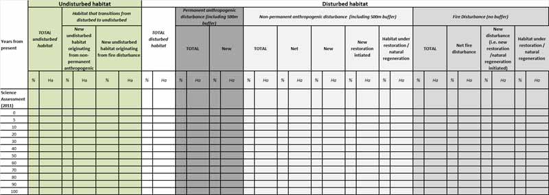
A habitat condition balance sheet will illustrate how the quantity of undisturbed habitat is changing over time to either maintain or achieve at least 65% undisturbed habitat in the range. A suggested balance sheet template is presented below as guidance (Table 1). Jurisdictions should alter the balance sheet format as needed. A detailed Excel spreadsheet is included in the Range Plan Guidance package as Appendix C to assist jurisdictions with the completion of the habitat balance sheet. Important points to remember:
- Adaptive management will be required in the event of a large natural disturbance.
- Habitat under restoration does not contribute to the 65% until it becomes undisturbed as per definition in the recovery strategy.
- Disturbed habitat includes a 500m buffer around the actual footprint of anthropogenic disturbance. In accordance with the definition of undisturbed habitat, the 500m buffer cannot be factored into the calculation of 65% undisturbed habitat, until such time as the disturbed habitat becomes undisturbed. Fire disturbance is not buffered.
- The time periods presented in the template (Table 1) are guidelines. These time periods may be changed by the jurisdiction to correspond with particular provincial/territorial timelines (e.g. timelines associated with habitat restoration or lease agreements).
- The first two rows of the balance sheet (Refer to row headings: "Scientific Assessment" and "Present") should be populated with data provided in section 4.1.
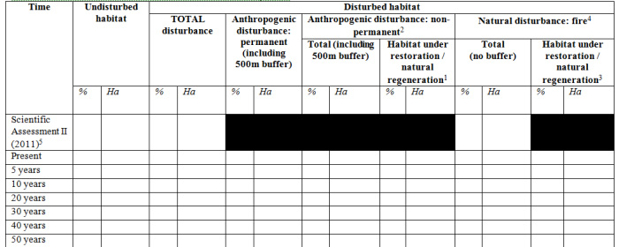
Long description for Table 1
Table 1 is a suggested balance sheet template that will illustrate how the quantity of undisturbed habitat is changing over time to either maintain or achieve at least 65% undisturbed habitat in the range. Once filled, the table would indicate the total percentage and area (ha) of undisturbed and disturbed habitat within a range. The amount of disturbed habitat would be further subdivided into permanent anthropogenic disturbance (with a 500m buffer), non-permanent anthropogenic disturbance (with a 500m buffer), including the amount of disturbed habitat that is under restoration or natural regeneration, and fire disturbance, including the amount of fire disturbed habitat under restoration or natural regeneration. The percentage and area of undisturbed and disturbed habitat at the time of the 2011 scientific assessment would be presented, and then the full habitat conditions as mentioned above would be assessed at year 0 (referred to as present), and projected for years 5, 10, 20, 30, 40 and 50 etc.1 Refers to habitat that originated from anthropogenic disturbance and is currently being restored/naturally regenerating. This disturbance is also included in the total anthropogenic disturbance: non-permanent2.
3 Refers to habitat that originated from fire disturbance and is currently being restored/naturally regenerating. This disturbance is also included in the total natural disturbance: fire.4.
5 The 2011 Scientific Assessment did not distinguish between permanent and non-permanent disturbances. Information on habitat under restoration/natural regeneration is not available in the 2011 Scientific Assessment..
6 Critical Habitat Protection
Range plans provide an opportunity for the jurisdiction to outline its plan for the protection of boreal caribou critical habitat in the range. The range plans, consistent with the recovery strategy, are one factor the Minister of Environment and Climate Change can consider in forming an opinion on whether the laws of the province or territory effectively protect critical habitat within each boreal caribou range. As such, it would be useful to include any information that the jurisdiction feels would be pertinent for the Minister of Environment and Climate Change to consider in assessing whether critical habitat protection is in place or is being pursued throughout the range. If the Minister is of the opinion that there are no provisions in or measures under SARA or another Act of Parliament that protect the critical habitat (including a section 11 agreement) and the laws of the province or territory do not effectively protect the critical habitat, the Minister of Environment and Climate Change is required to recommend to the Governor in Council that a protection order be made.
6.1 Range-specific activities likely to result in the destruction of critical habitat
SARA requires that a recovery strategy identify examples of activities likely to destroy critical habitat. Destruction is determined on a case by case basis. Destruction would result if part of the critical habitat were degraded, either permanently or temporarily, such that it would not serve its function when needed by boreal caribou. Destruction may result from a single activity, multiple activities at one point in time, or from the cumulative effects of one or more activities over time.
As identified in the recovery strategy, activities that are likely to result in the destruction of critical habitat, include, but are not limited to, the following:
- Any activity resulting in the direct loss of boreal caribou critical habitat. Examples of such activities include: conversion of habitat to agriculture, forestry cut blocks, mines, and industrial and infrastructure development.
- Any activity resulting in the degradation of critical habitat leading to a reduced, but not total loss of both habitat quality and availability for boreal caribou. Examples of such activities include: pollution, drainage of an area, and flooding.
- Any activity resulting in the fragmentation of habitat by human-made linear features. Examples of such activities include: road development, seismic lines, pipelines, and hydroelectric corridors.
The likelihood that critical habitat will be destroyed is increased if any one of these activities, or combination thereof, were to occur in such a manner, place and time, that after appropriate mitigation techniques (see Appendix I of the recovery strategy) any one of the following were to occur:
- compromise the ability of a range to be maintained at 65% undisturbed habitat;
- compromise the ability of a range to be restored to 65% undisturbed habitat;
- reduce connectivity within a range;
- increase predator and/or alternate prey access to undisturbed areas; or
- remove or alter biophysical attributes necessary for boreal caribou.
This section should identify range-specific activities that are likely to result in direct loss, degradation, and/or fragmentation of habitat, relevant to the individual range. For example, if oil and gas development does not occur in a particular range, activities associated with it can be excluded from the information provided in this section. This section should outline the specific activities that are likely to result in the destruction of critical habitat for each relevant industry (e.g. oil and gas exploration and development, forestry, mining exploration and development, agriculture, tourism, transportation, etc.). Information on activities likely to result in the destruction of critical habitat for both current and foreseeableactivities is recommended. The information in this section could be displayed in a table, as shown in the example below.
| Activities likely to result in the destruction of critical habitat |
Current | Foreseeable | |
|---|---|---|---|
| Direct loss of habitat | Forestry cut blocks | x | x |
| Direct loss of habitat | Mines | x | x |
| Degradation of habitat | Pollution - mining development | x | x |
| Degradation of habitat | Pollution - oil and gas development | x | x |
| Fragmentation of habitat by human-made linear features |
Road development | x | x |
| Fragmentation of habitat by human-made linear features |
Seismic lines | x | x |
| Fragmentation of habitat by human-made linear features |
Pipelines | x | x |
| Fragmentation of habitat by human-made linear features |
Hydroelectric corridors | x | x |
| Other | - | - | - |
6.2 Current protection for critical habitat on non-federal lands
This section should outline the protection that is currently in place for boreal caribou critical habitat on non-federal lands, including legally-binding instruments and conservation measures. For ranges with <65% undisturbed habitat, the jurisdiction should outline the protection mechanisms currently in place that occur in the areas designated as contributing to the forecasted 65% undisturbed habitat, as well as the areas containing biophysical attributes or undisturbed habitat that occur outside of the targeted 65% areas (as identified in section 5). For ranges with ≥65% undisturbed habitat, the jurisdiction should outline the protection mechanisms currently in place that occur in the habitat designated as contributing to the 65% undisturbed habitat (as identified in section 5).
Using the activities likely to result in the destruction of critical habitat (see section 6.1), describe the laws of the province or territory (including any regulations, permits, licences, etc. that are enabled under those laws) and/or conservation measures (e.g. policies, best management practices, etc.) that are available to manage the activities and thereby prevent the destruction of critical habitat.
6.3 Steps being taken by jurisdiction
In ranges where protection is not fully in place, this section should identify the steps being taken by the jurisdiction to put legally-binding instruments and conservation measures in place with the intent of preventing the destruction of critical habitat or the particular activities from being undertaken that would likely result in the destruction of critical habitat and the expected timeline for their implementation. This will inform the completion of any reports required by the Minister of Environment and Climate Change under s. 63 of SARA.
6.4 Range plans as evidence of critical habitat protection
Environment and Climate Change Canada has developed a four-step process referred to as the "Critical Habitat Protection Assessment" (CHPA) to assess the protection of critical habitat on non-federal lands for each terrestrial species at risk, including boreal caribou. If the Range Plan Guidance is followed, Environment and Climate Change Canada will be able to use the information from section 6 to inform the CHPA for boreal caribou. Detailed range-specific information about the nature of activities likely to result in destruction of critical habitat (section 6.1) is used throughout the CHPA process.
Information for CHPA Step 1 – Assessment of Provincial/Territorial Laws
Jurisdictional information about the details of legally-binding instruments (section 6.2), including information about the history of application of the instrument, will be used to determine the strength of these instruments with respect to their ability to either explicitly protect critical habitat or to manage activities in such a way as to prevent destruction of critical habitat (CHPA Step 1). Each instrument is evaluated according to seven individual strength criteria, considering both the literal interpretation of the instrument as well as the history of its application. The seven strength criteria are:
- Constraints on Limitations/ Exemptions
- Constraints on Discretion
- Constraints on Permitting
- Offenses/Prohibitions
- Enforcement
- Penalties
- Definitions
A final determination of the overall strength of the instrument is made based on the strength ranks of the seven criteria considering the history of application. This information may result in the individual strength ranks for each criteria being higher, unchanged, or lower than when only the literal interpretation of the instrument was considered. Overall instrument strength rank is calculated as follows:
| Overall Instrument Strength Rank | Rules for determining Overall Instrument Strength Rank |
|---|---|
| Strong | All seven individual criteria are ranked strong. |
| Moderate | All seven individual criteria are ranked moderate or strong. |
| Weak | Any one of the seven individual criteria is ranked weak. |
Instruments with "moderate" or "strong" overall strength will be considered as providing protection for that portion (combination of land ownership/tenure) of critical habitat, with respect to the specific activity likely to destroy it (e.g. forestry, oil and gas etc.). An overall instrument strength rank of "weak" will be considered a gap in protection for that portion of critical habitat with respect to the specific activity likely to destroy it.
See separate CHPA documentation for details on the CHPA process and how the seven strength criteria are evaluated/ranked in Step 1.
Information for CHPA Step 2 – Assessment of Federal MeasuresFootnote1
If provisions or measures under a federal Act of Parliament (including SARA) are in place, they will be assessed in a similar manner as the provincial/territorial instruments. For example, a section11 conservation agreement that is negotiated under SARA, and may be informed by one or more range plans, would be assessed under CHPA Step 2 if the conservation agreement is written in such a way as to be mandatory and enforceable. If, however, the section11 conservation agreement is non-binding, it will be assessed under CHPA Step 3.
Information for CHPA Step 3 – Assess Risk of Critical Habitat Destruction
For portions of critical habitat where there is a gap in protection from legally binding instruments, jurisdictional information about the activities likely to destroy critical habitat (section 6.1), and existing conservation measures (section 6.2), will be reviewed in order to determine the risk that critical habitat destruction will occur (CHPA Step 3).
Conservation measures are ranked for three criteria:
- Coverage
- Relevance
- Reliability
CHPA Step 3 acknowledges that there may be situations when critical habitat is unlikely to be destroyed even in the absence of a regulatory regime that prohibits destruction. This determination is precautionary and therefore only a “low” or “very low” risk of critical habitat destruction is considered manageable/acceptable. If the residual risk of critical habitat destruction after CHPA Step 3 is anything other than “low” or “very low” (i.e. “medium”, “high” or “very high”) then it will be necessary to recommend that the Minister form an opinion regarding a lack of effective protection for those portions of critical habitat.
Range plans themselves could serve as conservation measures under CHPA Step 3 if:
- The Range Plan Guidance is followed and the information provided in the range plan is technically sound (addresses the coverage and relevance criteria);
- In particular, the range plan should: i) Identify the current or forecasted 65% undisturbed habitat; ii) For ranges with <65% undisturbed habitat, provide a clear restoration strategy for how the 65% undisturbed habitat will be achieved, including expected timelines; and iii) Outline the jurisdiction’s plan to manage activities in a way that does not result in destruction of critical habitat by any activity. For ranges with <65% undisturbed habitat, this includes while the habitat is being restored to an undisturbed condition.
- The range plan includes, or is accompanied by, policy or program statements that are formally adopted by the jurisdiction and reflect the jurisdiction’s commitment to the range plan outcomes, along with resourcing commitments to implement the range plan and monitor the outcomes; or the range plan is used as the basis for a conservation agreement under section 11 of SARA (addresses the reliability criterion); and
- The jurisdiction has a strong history of following through with policy statements or provides other evidence that the policy position will be reliable as a mechanism to ensure destruction of critical habitat does not occur (addresses the reliability criterion).
If each of these components are in place, when Environment and Climate Change Canada is considering CHPA Step 3, it will be possible to assign a strength score of “very strong” to the range plan / conservation measure, because it will have 100% coverage of the relevant portions of critical habitat, be highly relevant to the pathway of effect of the activities on critical habitat, and be strongly reliable. Conservation measures that score “high” for coverage, relevance, and reliability are ranked “very strong” during CHPA Step 3, which indicates a “low” or “very low” residual risk that critical habitat destruction will occur.
See separate CHPA documentation for details on the CHPA process and how the three strength criteria for conservation measures are evaluated/ranked in Step 3.
CHPA Conclusions
If all the components described above are contained in a boreal caribou range plan, Environment and Climate Change Canada’s CHPA will be able to indicate that there is a combination of:
- Strong or moderate legally-binding instruments in place to provide protection of critical habitat; and / or
- Very strong conservation measure (i.e. range plan) in place for any areas where there are gaps in legally-binding instruments.
This combination will indicate a "low" overall risk of critical habitat destruction, and it will not be necessary to recommend that the Minister form an opinion regarding a lack of effective protection, for the area to which the range plan applies.
C. Monitoring Section
7. Monitoring
This section outlines monitoring related to habitat. Population monitoring for all local populations is required to test the efficacy of management actions and adapt those management actions as appropriate. Any information regarding population monitoring can be provided to Environment and Climate Change Canada through updates to the recovery strategy or action plans.
7.1 Habitat condition monitoring
This section should provide an approach for monitoring habitat condition, including the following:
- anthropogenic disturbance
- natural disturbance
- critical habitat (i.e. at least 65% undisturbed habitat and biophysical attributes)
- habitat restoration/natural regeneration
7.2 Protection measures monitoring
For ranges where critical habitat protection is in place and operationalized, as identified in section 6.2, this section should outline the approach for tracking and monitoring the continued persistence and application of the legally-binding instruments and conservation measures that protect critical habitat on non-federal lands. The approach must provide a means to verify that protection measures are being actively employed and are resulting in the protection of critical habitat. Environment and Climate Change Canada will be implementing a process to verify that protection is effective over time.
D. Timelines Section
8. Timelines: Reporting and Range Plan Updates
8.1 Reporting on range plan implementation and monitoring
This section should include expected timelines for when the jurisdiction intends to report on range plan implementation and monitoring. Environment and Climate Change Canada recommends that jurisdictions synchronize reporting on range plan implementation and monitoring with the five-year SARA reporting requirement (i.e. SARA s.46, the competent minister must report on the implementation of the recovery strategy and the progress towards meeting its objectives). The first report is due within five years of the posting of the recovery strategy on the public registry (i.e. by October 5, 2017). Report preparation will therefore likely begin the previous year.
Jurisdictions should report on the outcomes of habitat condition monitoring and protection measures monitoring, as applicable, including:
- what has been observed through the monitoring
- whether current practices are having a positive or negative effect on the habitat condition, and
- adaptive management approaches where necessary in order to achieve positive outcomes (if current practices are not successful) or to improve current outcomes even in cases where the result is positive.
8.2 Range plan updates
Range plans may be updated by the jurisdictions over time to reflect changes in habitat and population condition for any given range. Note that range plans should also be updated following any significant natural disturbance event (e.g. forest fires) or when new information on important areas for boreal caribou becomes available. Updated or amended range plans can be submitted as necessary.
References
Environment Canada. 2011. Scientific Assessment to Support the Identification of Critical Habitat for Woodland Caribou (Rangifer tarandus caribou), Boreal Population, in Canada. Ottawa, ON. 115pp. plus Appendices.:
Environment Canada. 2012. Recovery Strategy for the Woodland Caribou (Rangifer tarandus caribou), Boreal population, in Canada. Species at Risk Act Recovery Strategy Series. Environment Canada, Ottawa. xi + 138pp.
Glossary
The following terms are defined in accordance with their use in this document.
Biophysical attributes: habitat characteristics required by boreal caribou to carry out life processes (see Appendix H in the recovery strategy).
Critical habitat: the habitat that is necessary for the survival or recovery of a listed wildlife species and that is identified as the species’ critical habitat in the recovery strategy or in an action plan for the species.
Disturbed habitat: habitat showing: i) anthropogenic disturbance visible on Landsat at a scale of 1:50,000, including habitat within a 500 m buffer of the anthropogenic disturbance; and/or ii) fire disturbance in the last 40 years, as identified in data from each provincial and territorial jurisdiction (without buffer).
Existing habitat: the entire boreal caribou range area minus permanent alterations.
Permanent alterations: existing features found within a range, such as industrial and urban developments, permanent infrastructure, and graded or paved roads that do not currently possess or have the potential to possess the biophysical attributes of critical habitat for boreal caribou.
Non-permanent disturbance: existing features found within a range, such as seismic lines and commercial foresting areas that do not currently possess, but have the potential to possess the biophysical attributes of critical habitat for boreal caribou.
Undisturbed habitat: habitat not showing any: i) anthropogenic disturbance visible on Landsat at a scale of 1:50,000, including habitat within a 500 m buffer of the anthropogenic disturbance; and/or ii) fire disturbance in the last 40 years, as identified in data from each provincial and territorial jurisdiction(without buffer). Disturbance within the 500 m buffer would result in a reduction of the undisturbed habitat.Footnote1
Appendix A: Boreal Caribou Range Plan Checklist
A. Context Section
- ✓ Describe any recovery/management goals identified for boreal caribou by the jurisdiction and list provincial/territorial policy statements and planning documents related to boreal caribou recovery. Explain how they link to range planning.
- ✓ Outline the process followed to develop the range plan (e.g. collaboration with directly affected stakeholders, cooperation with Indigenous peoples, etc.).
- ✓ Provide status of self-sustainability for the local population and lines of evidence used to conduct Environment and Climate Change Canada’s integrated risk assessment (population size estimate, population trend, % disturbed habitat), as stated in the recovery strategy.
B. Habitat Section
- ✓ Current habitat condition and important areas for boreal caribou:
- Map and describe habitat condition and disturbance levels at two time periods:
- Map and describe important areas for boreal caribou based on biophysical attributes and patterns of habitat use by boreal caribou (e.g. telemetry, survey info)
- ✓ Managing the 65% undisturbed habitat:
- Describe the measures and steps the jurisdiction is and will be taking to manage the interaction between human disturbance, natural disturbance, and the need to maintain or establish an ongoing, dynamic state of a minimum of 65% of the range as undisturbed habitat.
- Identify, describe, and map the current and forecasted location of the minimum 65% undisturbed habitat, identifying the following:
- Areas that presently contribute to 65% undisturbed habitat;
- Areas that do not and will not contribute to the 65% undisturbed habitat; and
- Areas that will be or are naturally regenerating or being restored. Include a restoration strategy.
- For ranges with <65% undisturbed habitat, demonstrate an increase in the quantity of undisturbed habitat over time (see Table 1: balance sheet).
- ✓ Critical habitat protection:
- Identify range-specific activities that are likely to result in the destruction of critical habitat for each relevant industry.
- Outline the protection that is currently in place for boreal caribou critical habitat on non-federal lands, including legally-binding instruments and conservation measures.
- In ranges where protection is not fully in place identify the steps being taken by the jurisdiction to put measures in place.
C. Monitoring Section
- ✓ Describe the approach for monitoring habitat condition
- ✓ Describe the approach for monitoring protection measures
Timelines Section
- ✓ Outline the expected timelines for reporting on range plan implementation and monitoring.
Appendix B: Example High Disturbance Scenario: Illustrating The Achievement Of 65% Undisturbed Habitat Over Time
The following set of maps illustrates an example scenario of the 65% undisturbed habitat being achieved over time in a hypothetical high disturbance boreal caribou range (22% undisturbed habitat at present). The set includes maps of the habitat condition of the range at four time periods: present, 20 years, 40 years, and 60 years. 65% undisturbed habitat is achieved in the final map at 60 years. These maps represent a simplified hypothetical scenario and were produced for illustrative purposes only. It is understood that restoration may take longer than the timelines suggested by these maps and that jurisdictions will not be able to predict the exact location of future fire disturbance. It is not expected that jurisdictions develop this series of maps. Instead, jurisdictions will use the tools and information available to them to develop maps indicating the forecasted location of the 65% undisturbed habitat, as described in section 5.2.
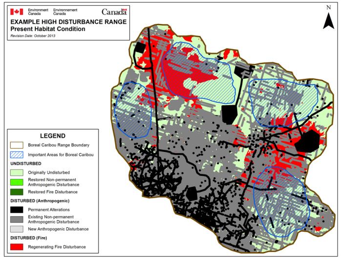
Long description for Figure a)
Illustration of a hypothetical highly disturbed boreal caribou range (22% undisturbed habitat), showing important areas for boreal caribou and different types of disturbance throughout the range (e.g. permanent and non-permanent anthropogenic disturbance, fire disturbance). There is very little undisturbed habitat left in the range, including within the areas identified as important for boreal caribou.
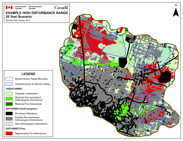
Long description for Figure b)
Illustration of a hypothetical highly disturbed boreal caribou range after 20 years of restoration actions and natural regeneration (26% undisturbed habitat), showing important areas for boreal caribou and different types of disturbance throughout the range (e.g. permanent and non-permanent anthropogenic disturbance, fire disturbance). There are some small areas of restored/naturally regenerated anthropogenic disturbance and fire disturbance. There is also an additional area of fire disturbance from what was on the previous map, and that area has begun to naturally regenerate.
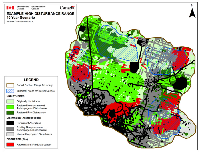
Long description for Figure c)
Illustration of a hypothetical highly disturbed boreal caribou range after 40 years of restoration actions and natural regeneration (47% undisturbed habitat), showing important areas for boreal caribou and different types of disturbance throughout the range (e.g. permanent and non-permanent anthropogenic disturbance, fire disturbance). There are more areas of restored/naturally regenerated anthropogenic disturbance and fire disturbance compared to the previous map. Restoration is focussed on the important areas for boreal caribou as well as areas in between, thus increasing connectivity within the range. New areas of fire disturbance appear on the map, illustrating the unpredictability of fire.
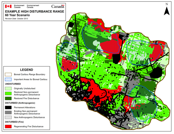
Long description for Figure d)
Illustration of a hypothetical highly disturbed boreal caribou range after 60 years of restoration actions and natural regeneration (65% undisturbed habitat), showing important areas for boreal caribou and different types of disturbance throughout the range (e.g. permanent and non-permanent disturbance, fire disturbance). There are many more areas of restored/naturally regenerated anthropogenic and fire disturbance throughout the range, compared to previous maps, and almost no remaining non-permanent anthropogenic disturbance within the important areas for boreal caribou, indicating these disturbances have been restored. There are also regenerating and restored areas of fire disturbance, illustrating the complexity of fire dynamics within the boreal forest.
Appendix C: Detailed Habitat Condition Balance Spreadsheet
See the attached Excel spreadsheet, Detailed Habitat Condition Balance Spreadsheet (26.8 kb).