
Dun skipper (Euphyes vestris vestris) proposed recovery strategy 2017
Official title: Recovery Strategy for Dun Skipper (Euphyes vestris vestris) in Canada - 2017 [Proposed]
Table of contents
Species at Risk Act
Recovery Strategy Series
Adopted under Section 44 of SARA
Dun Skipper vestris subspecies
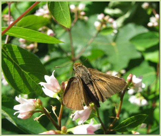
Photo: © Denis Knopp, 2017
Part 1 - Table of contents
- Part 1 – Federal Addition to the Recovery Plan for Dun Skipper (Euphyes vestris) in British Columbia, prepared by Environment and Climate Change Canada
List of figures
- Figure 1. Critical habitat for Dun Skipper vestris subspecies at van Home Creek (Population 3; 329.6 ha), Koksilah River (Population 12; 329.6 ha), and west of Shawnigan Lake (Population 9; 329.6 ha), B.C. is represented by the yellow shaded polygons (units) where the criteria and methodology set out in Section 1.1 are met. The 1 km x 1 km UTM grid overlay shown on this figure is a standardized national grid system that indicates the general geographic area within which critical habitat is found in Canada. Areas outside of the shaded yellow polygons do not contain critical habitat.
- Figure 2. Critical habitat for Dun Skipper vestris subspecies at Nanaimo River (Population 6; 682.0 ha) and Big Sicker Mountain (Population 10; 329.6 ha), B.C. is represented by the yellow shaded polygons (units) where the criteria and methodology set out in Section 1.1 are met. The 1 km x 1 km UTM grid overlay shown on this figure is a standardized national grid system that indicates the general geographic area within which critical habitat is found in Canada. Areas outside of the shaded yellow polygons do not contain critical habitat.
- Figure 3. Critical habitat for Dun Skipper vestris subspecies northeast of Port Alberni (Population 7; 434.7 ha), at Denman Island (Population 18; 739.2 ha), and at Hornby Island (Population 21; 129.1 ha), B.C. is represented by the yellow shaded polygons (units) where the criteria and methodology set out in Section 1.1 are met. The 1 km x 1 km UTM grid overlay shown on this figure is a standardized national grid system that indicates the general geographic within which critical habitat is found in Canada. Areas outside of the shaded yellow polygons do not contain critical habitat.
- Figure 4. Critical habitat for Dun Skipper vestris subspecies at Mount Currie (Population 8; 329.6 ha), Blackwater Creek (Population 26; 329.6 ha), and Railroad Creek (Population 27; 329.6 ha), B.C. is represented by the yellow shaded polygons (units) where the criteria and methodology set out in Section 1.1 are met. The 1 km x 1 km UTM grid overlay shown on this figure is a standardized national grid system that indicates the general geographic area within which critical habitat is found in Canada. Areas outside of the shaded yellow polygons do not contain critical habitat
- Figure 5. Critical habitat for Dun Skipper vestris subspecies south of Lytton (Population 25; 724.0 ha) and at Boston Bar (Population 16; 3063.7 ha), B.C. is represented by the yellow shaded polygons (units) where the criteria and methodology set out in Section 1.1 are met. The 1 km x 1 km UTM grid overlay shown on this figure is a standardized national grid system that indicates the general geographic area within which critical habitat is found in Canada. Areas outside of the shaded yellow polygons do not contain critical habitat.
- Figure 6. Critical habitat for Dun Skipper vestris subspecies at Dog Mountain (Population 17; 664.9 ha) and at Yale (Population 24; 329.6 ha), B.C. is represented by the yellow shaded polygons (units) where the criteria and methodology set out in Section 1.1 are met. The 1 km x 1 km UTM grid overlay shown on this figure is a standardized national grid system that indicates the general geographic area within which critical habitat is found in Canada. Areas outside of the shaded yellow polygons do not contain critical habitat.
- Figure 7. Critical habitat for Dun Skipper vestris subspecies at Saltspring Island (Population 19; 666.0 ha), B.C. is represented by the yellow shaded polygons (units) where the criteria and methodology set out in Section 1.1 are met. The 1 km x 1 km UTM grid overlay shown on this figure is a standardized national grid system that indicates the general geographic area within which critical habitat is found in Canada. Areas outside of the shaded yellow polygons do not contain critical habitat.
- Figure 8. Critical habitat for Dun Skipper vestris subspecies at Burns Bog (Population 20; 454.3 ha), B.C. is represented by the yellow shaded polygons (units) where the criteria and methodology set out in Section 1.1 are met. The 1 km x 1 km UTM grid overlay shown on this figure is a standardized national grid system that indicates the general geographic area within which critical habitat is found in Canada. Areas outside of the shaded yellow polygons do not contain critical habitat.
- Figure 9. Critical habitat for Dun Skipper vestris subspecies west of Morris Lake (Population 22; 659.2 ha) and at Soowahlie Indian Reserve 14 (Population 23; 329.6 ha), B.C. is represented by the yellow shaded polygons (units) where the criteria and methodology set out in Section 1.1 are met. The 1 km x 1 km UTM grid overlay shown on this figure is a standardized national grid system that indicates the general geographic area within which critical habitat is found in Canada. Areas outside of the shaded yellow polygons do not contain critical habitat.
List of tables
- Tables 1. Conservation Status of Dun Skipper vestris subspecies (NatureServe 2015, B.C. Conservation Data Center 2015, B.C. Conservation Framework 2015).
- Tables 2. Summary of Dun Skipper populations in B.C. For each population (Pop.), the location, date of last observation (Last Obs.), and current status are described.
- Tables 3. Schedule of Studies to Identify Additional Critical Habitat
- Tables 4. Activities likely to result in the destruction of critical habitat for Dun Skipper vestris subspecies. IUCN Threat numbers are in accordance with the IUCN-CMP (World Conservation Union–Conservation Measures Partnership) unified threats classification system (CMP 2010).
Part 2 - Table of contents
- Part 2 – Recovery Strategy for the Dun Skipper (Euphyes vestris) in British Columbia, prepared by the British Columbia Ministry of Environment
- Document Information
- 1 COSEWIC Species assessment information
- 2 Species status information
- 3 Species information
- 4 Threats
- 5 Recovery goal and objectives
- 6 Approaches to meet recovery objectives
- 7 Information on habitat needed to meet recovery goal
- 8 Measuring progress
- 9 Effects on other species
- 10 References
- Appendix 1. IUCN threats to each biological population.
List of tables
- Table 1. Status and description of known Dun Skipper populations in B.C. as of 2012.
- Table 2. Threat classification table for Dun Skipper.
- Table 3. Existing mechanisms that afford habitat protection for Dun Skipper.
- Table 4. Recovery planning table for Dun Skipper.
- Table 5. Studies needed to describe survival/recovery habitat to meet the population and distribution goal for Dun Skipper.
List of figures
- Figure 1. Dun Skipper (Euphyes vestris) adults (male), taken July 1, 2009, adjacent to a gas pipeline right-of-way near Hope, B.C. Photograph by Denis Knopp.
- Figure 2. Dun Skipper (Euphyes vestris) adults (male), taken July 7, 2010, adjacent to a gas pipeline right-of-way near Hope, B.C. Photograph by Denis Knopp.
- Figure 3. Dun Skipper distribution in North America. Two subspecies occur in Canada (Euphyes vestris vestris and E. vestris metacomet). The other 2 subspecies (E. vestris kiowah and E. vestris harbisoni) range in the United States and Mexico.
- Figure 4. Dun Skipper distribution in British Columbia (B.C. Conservation Data Centre 2013).