
Recovery Strategy for the Streambank Lupine (Lupinus rivularis) in Canada - 2016 [Proposed]
Streambank Lupine

2016
Recovery Strategy for the Streambank Lupine (Lupinus rivularis) in Canada - 2016 [Proposed]

Recommended citation:
Environment Canada. 2016. Recovery Strategy for the Streambank Lupine (Lupinus rivularis) in Canada [Proposed]. Species at Risk Act Recovery Strategy Series. Environment Canada, Ottawa. 13 pp. + Annex.
For copies of the recovery strategy, or for additional information on species at risk, including the Committee on the Status of Endangered Wildlife in Canada (COSEWIC) Status Reports, residence descriptions, action plans, and other related recovery documents, please visit the Species at Risk (SAR) Public Registry.
Cover illustration: © Brian Klinkenberg
Également disponible en français sous le titre
« Programme de rétablissement du lupin des ruisseaux (Lupinus rivularis) au Canada [Proposition] »
Content (excluding the illustrations) may be used without permission, with appropriate credit to the source.
Recovery Strategy for the Streambank Lupine (Lupinus rivularis) in Canada - 2016
Under the Accord for the Protection of Species at Risk (1996), the federal, provincial, and territorial governments agreed to work together on legislation, programs, and policies to protect wildlife species at risk throughout Canada.
In the spirit of cooperation of the Accord, the Government of British Columbia has given permission to the Government of Canada to adopt the “Recovery Plan for Streambank Lupine (Lupinus rivularis) in British Columbia” (Part 2) under Section 44 of the Species at Risk Act (SARA). Environment Canada has included a federal addition (Part 1) which completes the SARA requirements for this recovery strategy.
The federal recovery strategy for the Streambank Lupine in Canada consists of two parts:
- Part 1 – Federal Addition to the “Recovery Plan for Streambank Lupine (Lupinus rivularis) in British Columbia”, prepared by Environment Canada.
- Part 2 – Recovery Plan for Streambank Lupine (Lupinus rivularis) in British Columbia prepared by the Streambank Lupine Recovery Team for the British Columbia Ministry of Environment.
The federal, provincial, and territorial government signatories under the Accord for the Protection of Species at Risk (1996) agreed to establish complementary legislation and programs that provide for effective protection of species at risk throughout Canada. Under the Species at Risk Act (S.C. 2002, c.29) (SARA), the federal competent ministers are responsible for the preparation of recovery strategies for listed Extirpated, Endangered, and Threatened species and are required to report on progress within five years after the publication of the final document on the SAR Public Registry.
The Minister of the Environment is the competent minister under SARA for the Streambank Lupine and has prepared the federal component of this recovery strategy (Part 1), as per section 37 of SARA. It has been prepared in cooperation with the Province of British Columbia as per section 39(1) of SARA. SARA section 44 allows the Minister to adopt all or part of an existing plan for the species if it meets the requirements under SARA for content (sub-sections 41(1) or (2)). The Province of British Columbia provided the attached recovery plan for Streambank Lupine (Part 2) as science advice to the jurisdictions responsible for managing the species in British Columbia. It was prepared in cooperation with Environment Canada.
Success in the recovery of this species depends on the commitment and cooperation of many different constituencies that will be involved in implementing the directions set out in this strategy and will not be achieved by Environment Canada, or any other jurisdiction alone. All Canadians are invited to join in supporting and implementing this strategy for the benefit of the Streambank Lupine and Canadian society as a whole.
This recovery strategy will be followed by one or more action plans that will provide information on recovery measures to be taken by Environment Canada and other jurisdictions and/or organizations involved in the conservation of the species. Implementation of this strategy is subject to appropriations, priorities, and budgetary constraints of the participating jurisdictions and organizations.
The recovery strategy sets the strategic direction to arrest or reverse the decline of the species, including identification of critical habitat to the extent possible. It provides all Canadians with information to help take action on species conservation. When the recovery strategy identifies critical habitat, there may be future regulatory implications, depending on where the critical habitat is identified. SARA requires that critical habitat identified within federal protected areas be described in the Canada Gazette, after which prohibitions against its destruction will apply. For critical habitat located on federal lands outside of federal protected areas, the Minister of Environment and Climate Change must either make a statement on existing legal protection or make an order so that the prohibition against destruction of critical habitat applies. For critical habitat located on non-federal lands, if the Minister of Environment and Climate Change forms the opinion that any portion of critical habitat is not protected by provisions in or measures under SARA or other Acts of Parliament, and not effectively protected by the laws of the province or territory, SARA requires that the Minister recommend that the Governor in Council make an order to extend the prohibition against destruction of critical habitat to that portion. The discretion to protect critical habitat on non-federal lands that is not otherwise protected rests with the Governor in Council.
The following sections have been included to address specific requirements of SARA that are not addressed in the Recovery Plan for Streambank Lupine (Lupinus rivularis) in British Columbia (Part 2 of this document, referred to henceforth as “the provincial recovery plan”) and to provide updated or additional information.
Under SARA, there are specific requirements and processes set out regarding the protection of critical habitat. Therefore, statements in the provincial recovery plan referring to protection of the species’ habitat may not directly correspond to federal requirements. Recovery measures dealing with the protection of habitat are adopted; however, whether these measures will result in protection of critical habitat under SARA will be assessed following publication of the federal recovery strategy.
This section provides updated information to “Section 3.2: Populations and Distribution” in the provincial recovery plan. Since publication of the provincial recovery plan, a new population has become established due to recovery efforts. Population #9 was deliberately introduced by the Streambank Lupine Recovery Team within Deas Island Regional Park in 2010 and the most recent count recorded 20-25 plants (D. Hanna pers. comm. 2015). This population meets the criteria of being a successful introduction, in that it has naturally persisted for a minimum time period of 5 years. Recovery efforts have also been initiated on nearby Kirkland Island in the South Arm Marshes Wildlife Management Area in 2013 but so far have been unsuccessful (D. Hanna pers. comm. 2015). Therefore, the population and distribution objectives adopted from the provincial recovery plan includes Population #9 plus the populations identified in the provincial recovery plan.
This section replaces “Section 7.1: Description of Survival/Recovery Habitat” in the provincial recovery plan.
Section 41 (1)(c) of SARA requires that recovery strategies include an identification of the species’ critical habitat, to the extent possible, as well as examples of activities that are likely to result in its destruction. A primary consideration in the identification of critical habitat is the amount, quality, and locations of habitat needed to achieve the population and distribution objectives.
The 2014 provincial recovery plan for Streambank Lupine includes a written description of habitat requirements. Environment Canada accepts the description of habitat requirements provided in the provincial recovery plan, as the basis for critical habitat identification in the federal recovery strategy, with the inclusion of geospatial areas containing critical habitat, and with other modification (as follows) to address specific requirements of SARA. More precise boundaries may be mapped, and additional critical habitat may be added in the future if additional information supports the inclusion of areas beyond those currently identified.
Geospatial location of areas containing critical habitat
Critical habitat is identified for the seven known extant populationsFootnote1 of Streambank Lupine; these are linked with the population numbers provided in the provincial recovery plan below, excepting the addition of Population #9 (Delta-Deas Island). All of the populations occur near the coast in southwestern British Columbia (Figures 1-4):
- Population #2 (2a: Delta-Alaska Way and 2b: Surrey-Elevator Road)
- Population #3 (Delta-BNSFFootnote2/Chatterton)
- Population #4 (Richmond-Blundell)
- Population #5 (5a: Port Coquitlam-Kingsway south and 5b: Port Coquitlam-Kingsway north)
- Population #7 (Port Coquitlam-Pitt River Dyke)
- Population #8 (Surrey-Grace Road)
- Population #9 (Delta-Deas Island)
The area containing critical habitat for Streambank Lupine is identified based on the area occupied by individual plants or patches of plants, including the associated potential location error from Global Positioning System (GPS) units (ranging from 5 m to 25 m uncertainty distance), plus an additional 50 m (i.e., critical function zone distanceFootnote3) to encompass immediately adjacent areas. Ecosystem processes that occur on banks that support Streambank Lupine are integral to the production and maintenance of suitable microhabitat conditions. Where these banks are apparent as a distinct ecological featureFootnote4 at the landscape scale, the entire portion of the bank associated with the plant or patch of plants is also identified as critical habitat. Where two sub-populations are located less than 1 km apart in association with a continuous identifiable ecological feature (e.g., along a stream reach or sand/silt bank), the connecting habitat is also identified as critical habitat to maintain connectivity. A 50 m critical function zone is applied to the connecting habitat to maintain suitable habitat conditions.
Critical habitat could not be identified at four sites: Population #6 (possibly extirpated, status unknown), Population #2, subpopulation C (which is extirpated), Population #1 (which is a historical record – associated with a high level of location uncertainty, and unknown “extant” status) and one new (2015) population resulting from deliberate, recent, introduction attempts at Kirkland Island in the South Arm Marshes Wildlife Management Area within the Fraser Delta. An additional potentially new population has been reported (2007) in the Cowichan area on Vancouver Island that requires verification and critical habitat identification once verified. The schedule of studies (Section 2.2) outlines the activities required to identify additional critical habitat necessary to support the population and distribution objectives of the species.
Biophysical attributes of critical habitat
Within the areas identified as containing critical habitat, critical habitat is identified wherever the following biophysical attributes occur:
- River or creek banks, composed of various substrates (including gravel, cobble, sand, or silt);
- Areas with minimal ground cover (no developed grass, tree, or shrub layer) that are natural or anthropogenic in origin (e.g., sand or silt banks along railway right of ways, dykes, roadside edges, open lots or parking areas)
A critical function zone of 50 m around any extant plant occurrence is also identified as critical habitat, including all biophysical attributes listed above, as well as any other natural features (e.g., trees, shrubs) associated with the occurrence.
The areas containing critical habitat for Streambank Lupine (totalling 31.4 ha) are presented in Figures 1-4. Critical habitat for Streambank Lupine in Canada occurs within the shaded yellow polygon(s) (unit(s)) shown on each map, where the criteria outlined above are met. Within these polygons, unsuitable habitats (i.e., existing permanent infrastructure such as the running surface of paved roads, railway tracks, buildings) do not possess the biophysical attributes required by Streambank Lupine and they are not identified as critical habitat. The 1 km x 1 km UTM grid overlay shown on this figure is a standardized national grid system that highlights the general geographic area containing critical habitat, for land use planning and/or environmental assessment purposes.
Critical habitat can only be partially identified at this time. A schedule of studies has been included to provide the information necessary to complete the identification of critical habitat. The identification of critical habitat will be updated when the information becomes available, either in a revised recovery strategy or action plan(s).

Long description for Figure 1
Figure 1 shows a map with standardized 1 × 1 km grid squares that contain yellow shaded polygons of critical habitat of the Streambank Lupine populations # 2 in Delta and # 8 in Surrey, British Columbia. The map shows 1 grid square around the location of population # 8 in surrey on Grace road. It also shows 4 grid squares with the location of population # 2 in Delta, with a population being on Alaska Way and another on Elevator Road.

Long description for Figure 2
Figure 2 shows a map with standardized 1 × 1 km grid squares that contain yellow shaded polygons of critical habitat of the Streambank Lupine populations # 4 in Delta and # 3 Richmond, British Columbia. The map shows 1 grid square around the location of population #4 on Blundell Road in Richmond, and 2 grid squares around the location of population # 3 on the Burlington Northern Santa Fe Railway in Delta.

Long description for Figure 3
Figure 3 shows a map with standardized 1 × 1 km grid squares that contain yellow shaded polygons of critical habitat of the Streambank Lupine populations # 5 and # 7 in Port Coquitlam, British Columbia. The map shows 2 grid squares around the 2 locations of population # 5 on Kingsway avenue south and Kingsway avenue north in Port Coquitlam. It also shows 2 grid squares around the 2 locations of population # 7 on the Pitt River Dyke in Port Coquitlam.

Long description for Figure 4
Figure 4 shows a map with standardized 1 × 1 km grid squares that contain yellow shaded polygons of critical habitat of Streambank Lupine population # 9 at Deas Island, Delta, British Columbia. The map shows 1 grid square around the location of population # 9 at the north eastern end of Deas Island in Delta.
This section replaces “Section 7.2: Studies Needed to Describe Survival/Recovery Habitat” in the provincial recovery plan.
The following schedule of studies (Table 1) outlines the activities required to complete the identification of critical habitat for Streambank Lupine; population numbers are provided in reference to those in the provincial recovery plan.
| Description of activity | Rationale | Timeline |
|---|---|---|
| Undertake repeated, comprehensive surveys at Population 1 and Population 6, to reconfirm and identify any additional Streambank Lupine plants occurring in remaining patches of suitable habitat, and investigate the feasibility of habitat restoration at these sites so that Streambank Lupine can reestablish (via natural dispersal from adjacent populations, and/or deliberate reintroduction). | Critical habitat could not be identified for two populations owing to their "unknown" extant status. It is unknown if suitable habitat for Streambank Lupine persists at these sites, and/or if it could be made suitable with restoration. In addition, recent, comprehensive, targeted surveys are lacking. Without further information on the status and location of these populations, it is unknown whether there is sufficient critical habitat identified for Streambank Lupine. | 2016-2021 |
| Verify the identification of the potential new record of Streambank Lupine reported at Cowichan, Vancouver Island (2007) | This activity is required such that sufficient critical habitat is identified to meet the population and distribution objectives. | 2016-2021 |
| Monitor translocation trials on Kirkland Island to determine whether establishment of these introduced populations are successful, and/or to evaluate long-term persistence (i.e. over a minimum time period of 5 years). | This activity is required such that sufficient critical habitat is identified to meet the population and distribution objectives. | 2016-2021 |
Understanding what constitutes destruction of critical habitat is necessary for the protection and management of critical habitat. Destruction is determined on a case by case basis. Destruction would result if part of the critical habitat were degraded, either permanently or temporarily, such that it would not serve its function when needed by the species. Destruction may result from a single or multiple activities at one point in time or from the cumulative effects of one or more activities over time. Activities described in Table 2 include those likely to cause destruction of critical habitat for the species; destructive activities are not limited to those listed.
| Description of activity | Rationale | Additional Information including related IUCN threatFootnotea |
|---|---|---|
| Conversion, expansion or removal of existing railway right-of-ways, roadside edges, dykes, open lots and parking areas. | These activities result in direct loss by removal, or burial, of critical habitat. | Related IUCN Threat #4.1. Subpopulations 5a and 5b were partially destroyed through road expansion. Although there are no current plans for development at any of the Streambank Lupine locations, this activity should be monitored as any new project could result in the loss of a significant amount of Streambank Lupine habitat. |
| Maintenance activities (e.g. brushcutting or grading) at existing railway right-of-ways or roadside edges. | These activities may degrade or destroy habitat, e.g., by altering the soil surface or covering the ground with litter such that it is no longer suitable for Streambank Lupine regeneration. | Related IUCN Threat #7.3. As many populations of Streambank Lupine occur within right-of-ways, maintenance activities occur at most sites. Depending on frequency and scheduling, mowing and brushing may, in some circumstances, have a neutral or even beneficial effect on Streambank Lupine by reducing weed encroachment. Thresholds are unknown, however appropriate timing (i.e., post growing season and seed set) and application (i.e., avoiding soil disturbance) are essential to avoid destruction. |
| Inappropriate use of herbicides in invasive plant management activities or roadside/railway weed control. | Efforts to control invasive plants through chemical means (e.g., non-specific herbicides) can result in habitat toxicity such that critical habitat is no longer suitable for Streambank Lupine. | Related IUCN Threat #9.3. Spraying has occurred at a few sites in the past and may be used at these same sites and others in future. The use of herbicides has decreased or ceased at several sites (e.g., Populations 3a, 3b, 3c, 3d, and 7). Applies to all areas containing critical habitat, and also adjacent lands (i.e., those outside geospatial area containing critical habitat) where application may impact critical habitat through wind drift or residual effects. |
| Dumping of fill (sand/gravel) and/or general garbage | Debris left by people can destroy habitat (e.g. by burial) and/or otherwise degrade habitat quality such that it is no longer suitable for Streambank Lupine. | Related IUCN Threat #9.4. Many Streambank Lupine populations occur in areas easily accessed by people. In 2004, a portion of habitat at Alaska Way (affecting subpopulation 2a) was removed and covered with gravel fill. |
One or more action plans for Streambank Lupine will be posted on the Species at Risk Public Registry by 2021.
This section replaces “Section 9: Effects on Other Species” in the provincial recovery plan.
A strategic environmental assessment (SEA) is conducted on all SARA recovery planning documents, in accordance with the Cabinet Directive on the Environmental Assessment of Policy, Plan and Program Proposals. The purpose of a SEA is to incorporate environmental considerations into the development of public policies, plans, and program proposals to support environmentally sound decision-making and to evaluate whether the outcomes of a recovery planning document could affect any component of the environment or any of the Federal Sustainable Development Strategy’s (FSDS) goals and targets.
Recovery planning is intended to benefit species at risk and biodiversity in general. However, it is recognized that strategies may also inadvertently lead to environmental effects beyond the intended benefits. The planning process based on national guidelines directly incorporates consideration of all environmental effects, with a particular focus on possible impacts upon non-target species or habitats. The results of the SEA are incorporated directly into the strategy itself, but are also summarized below in this statement.
The provincial recovery plan for Streambank Lupine contains a section describing the effects of recovery activities on other species (i.e., Section 9). Environment Canada adopts this section of the provincial recovery plan as the statement on effects of recovery activities on the environment and other species. Recovery planning activities for Streambank Lupine will be implemented with consideration for all co-occurring species at risk, such that there are no negative impacts to these species or their habitats.
COSEWIC 2002. COSEWIC assessment and status report on the streambank lupine Lupinus rivularis in Canada. Committee on the Status of Endangered Wildlife in Canada. Ottawa. 36 pp.
Hanna, D., pers. comm. 2015. Email correspondence with Matt Huntley. Botanist, Vancouver, B.C.
Recovery Plan for Streambank Lupine
(Lupinus rivularis) in British Columbia
Prepared by Streambank Lupine Recovery Team

January 2014
- Acknowledgements
- Recovery Team Members
- Executive Summary
- Recovery Feasibility Summary
- 1 COSEWIC* Species Assessment Information
- 2 Species Status Information
- 3 Species Information
- 4 Threats
- 5 Recovery Goal and Objectives
- 6 Approaches to Meet Objectives
- 7 Information on Habitat Needed to Meet Recovery Goal
- 8 Measuring Progress
- 9 Effects on Other Species
- 10 References
- Table 1. Streambank lupine populations in British Columbia (B.C. Conservation Data Centre 2013)
- Table 2. Threat classification table for streambank lupine in British Columbia
- Table 3. Recovery planning table for streambank lupine
- Table 4. Studies needed to describe survival/recovery habitat to meet the recovery goal for streambank lupine
- Figure 1. North American range of streambank lupine
- Figure 2. Distribution of streambank lupine in the Lower Mainland area of southwestern B.C. as of 2013, shown by population and sub-population number (Table 1). Extirpated subpopulation 2c, and historical population 1 (located at Sooke, Vancouver Island B.C.) are not shown
British Columbia Recovery Strategy Series
Recovery Plan for Streambank Lupine (Lupinus rivularis) in British Columbia
Prepared by the Streambank Lupine Recovery Team
January 2014
This series presents the recovery documents that are prepared as advice to the Province of British Columbia on the general approach required to recover species at risk. The Province prepares recovery documents to ensure coordinated conservation actions and to meet its commitments to recover species at risk under the Accord for the Protection of Species at Risk in Canada and the Canada–British Columbia Agreement on Species at Risk.
Species at risk recovery is the process by which the decline of an endangered, threatened, or extirpated species is arrested or reversed, and threats are removed or reduced to improve the likelihood of a species’ persistence in the wild.
Recovery documents summarize the best available scientific and traditional information of a species or ecosystem to identify goals, objectives, and strategic approaches that provide a coordinated direction for recovery. These documents outline what is and what is not known about a species or ecosystem, identify threats to the species or ecosystem, and explain what should be done to mitigate those threats, as well as provide information on habitat needed for survival and recovery of the species. This information may be summarized in a recovery strategy followed by one or more action plans. The purpose of an action plan is to offer more detailed information to guide implementation of the recovery of a species or ecosystem. When sufficient information to guide implementation can be included from the onset, all of the information is presented together in a recovery plan.
Information provided in provincial recovery documents may be adopted by Environment Canada for inclusion in federal recovery documents that the federal agencies prepare to meet their commitments to recover species at risk under the Species at Risk Act.
The Province of British Columbia accepts the information in these documents as advice to inform implementation of recovery measures, including decisions regarding measures to protect habitat for the species.
Success in the recovery of a species depends on the commitment and cooperation of many different constituencies that may be involved in implementing the directions set out in this document. All British Columbians are encouraged to participate in these efforts.
To learn more about species at risk recovery in British Columbia, please visit the B.C. Ministry of Environment Recovery Planning webpage
Streambank Lupine Recovery Team. 2014. Recovery plan for streambank lupine (Lupinus rivularis) in British Columbia. Prepared for the B.C. Ministry of Environment, Victoria, BC. 24 pp.
Dawn Hanna
Additional copies can be downloaded from the B.C. Ministry of Environment Recovery Planning webpage.
Publication information
ISBN: 978-0-7726-6743-4
This recovery plan has been prepared by the Streambank Lupine Recovery Team, as advice to the responsible jurisdictions and organizations that may be involved in recovering the species. The British Columbia Ministry of Environment has received this advice as part of fulfilling its commitments under the Accord for the Protection of Species at Risk in Canada, and the Canada–British Columbia Agreement on Species at Risk.
This document identifies the recovery strategies that are deemed necessary, based on the best available scientific and traditional information, to recover streambank lupine populations in British Columbia. Recovery actions to achieve the goals and objectives identified herein are subject to the priorities and budgetary constraints of participatory agencies and organizations. These goals, objectives, and recovery approaches may be modified in the future to accommodate new objectives and findings.
The responsible jurisdictions and all members of the recovery team have had an opportunity to review this document. However, this document does not necessarily represent the official positions of the agencies or the personal views of all individuals on the recovery team.
Success in the recovery of this species depends on the commitment and cooperation of many different constituencies that may be involved in implementing the directions set out in this plan. The B.C. Ministry of Environment encourages all British Columbians to participate in the recovery of streambank lupine.
This recovery plan was completed by Terry McIntosh (consulting botanist; Vancouver, BC) and Dawn Hanna (botanist; Vancouver, BC) on behalf of the Streambank Lupine Recovery Team. It is based on an earlier draft prepared by Brian Klinkenberg (University of British Columbia, Vancouver, BC). The team acknowledges the assistance of Brenda Costanzo (Senior Vegetation Specialist, B.C. Ministry of Environment [MoE], Victoria, BC) and Lucy Reiss (Senior Terrestrial Habitat Planner, Canadian Wildlife Service, Environment Canada, Delta, BC), who provided advice for the recovery plan. Leah Westereng (B.C. MoE) provided technical review and policy guidance.
Sylvia Letay, B.C. Ministry of Environment (Chair)
Sophie Alain, Port Metro Vancouver (on leave)
Trudy Chatwin, B.C. Ministry of Environment
Anna Mária Csergő, Ph.D., Botanist (visiting scholar at University of B.C.)
Angela Danyluk, Corporation of Delta
Dawn Hanna, Vancouver Parks
Bill Herbst, City of Port Coquitlam
Kim Keskinen, Port Metro Vancouver
Terry McIntosh, Ph.D., Botanist, Vancouver
Brian Klinkenberg, Ph.D. (Co-Chair to May 2010), Geography Department, University of B.C.
Vicky Baker, University of British Columbia, Project Coordinator, Metropolis BC
Mike Brotherston, Corporation of Delta
Angelo Dalcin, P.Eng., Canadian Pacific Railway, Vegetation Management Specialist
Rose Klinkenberg, Botanist, Richmond
Gary Lewis, M.Sc., Phoenix Perennials and Specialty Plants Ltd.
Ian Parnell, Environment Canada, Canadian Wildlife Service
Luanne Patterson, Canadian National Railway, Environmental Protection Officer
Sharon Peters, Greater Vancouver Regional District, Senior Project Engineer
Lucy Reiss, Environment Canada, Species at Risk Recovery Unit
Danielle Wensauer, Fraser River Port Authority, Environmental Technician
Jeannette Whitton, Ph.D., Botany Department, University of British Columbia
Streambank lupine (Lupinus rivularis) is a perennial herbaceous plant. It is a western North American endemic, found along the Pacific coast from southwestern British Columbia (B.C.) to northern California. There are 8 populations of Streambank lupine in B.C., known from 14 reported sites (subpopulations).
Streambank lupine was designated as Endangered by the Committee on the Status of Endangered Wildlife in Canada (COSEWIC). It is listed as Endangered in Canada on Schedule 1 of the Species at Risk Act (SARA). In B.C., streambank lupine is ranked S1 (critically imperiled) by the Conservation Data Centre and is on the provincial Red list. The B.C. Conservation Framework ranks streambank lupine as priority 1 under goals 1 (contribute to global efforts for species and ecosystem conservation) and 3 (maintain the diversity of native species and ecosystems). Recovery is considered to be biologically and technically feasible.
Since streambank lupine was assessed by COSEWIC in 2002 (COSEWIC 2002), the general trend for known streambank lupine populations has been one of decline, as many of the populations have decreased in plant numbers and areal extent. The overall province-wide Threat Impact for this species is Very High. The greatest threats are invasive non-native/alien species, and agricultural and forestry effluents.
The population and distribution goal for streambank lupine is to maintain the abundance of all known extant populations as well as any other extant populations that may be identified or established at a later date within the species’ known and potential range. If feasible and where deemed necessary, augment existing populations in B.C.
The recovery objectives for streambank lupine are:
- Secure long-term protectionFootnote1 for extant populations and habitats of streambank lupine in B.C.
- Confirm distribution within the known range of the species in B.C.
- Address knowledge gaps relating to species’ biology, habitat requirements, and population demography, and disturbance dynamics.
- Clarify and mitigate threats to this species and its habitat including invasive plants, plant succession, and hybridization.
- Determine feasibility of augmenting existing populations.
The recovery of streambank lupine in B.C. is considered technically and biologically feasible based on the criteria outlined by the Government of Canada (2009):
- Individuals of the wildlife species that are capable of reproduction are available now or in the foreseeable future to sustain the population or improve its abundance.
Yes. Extant populations are reproducing via seeds and it is thought that this level of reproduction is sufficient to sustain or improve the abundance of these populations.
- Sufficient suitable habitat is available to support the species or could be made available through habitat management or restoration.
Yes. This species is extant in several locations with sufficient suitable habitat to support the species. There are also areas of unoccupied habitat that might be suitable for this species. These areas could be used to augment existing populations.
- The primary threats to the species or its habitat (including threats outside Canada) can be avoided or mitigated.
Yes. The primary threat (i.e., invasive non-native species) to the species or its habitat can be avoided or mitigated. The development of best management practices and training for landowners is one recovery action that could reduce this threat as well as other threats.
- Recovery techniques exist to achieve the population and distribution objectives or can be expected to be developed within a reasonable timeframe.
Yes. Standard recovery techniques exist and can be further developed in best management practices for the species, followed-up by training of landowners and maintenance crews. The potential to augment populations can be investigated.
Assessment Summary - November 2002
Common name: Streambank Lupine
Scientific name: Lupinus rivularis
Status: Endangered
Reason for designation: A highly restricted species with very few populations extant and extremely low numbers of plants remaining. Populations are all close to industrial and other development and at risk from impacts such as habitat loss, herbicide spraying, predation by exotic slugs and subject to genetic swamping through hybridization with a non-native lupine species.
Occurrence: British Columbia
Status history: Designated Endangered in November 2002. Assessment based on a new status report.
Streambank lupineFootnotea
Legal Designation
- FRPA:Footnoteb No
- OGAA:Footnoteb No
- B.C. Wildlife ActFootnotec: No
- SARA: Schedule 1 – Endangered (2005)
- B.C. List: Red
- B.C. Rank: S1 (2009)
- National Rank: N1(1989)
- Global Rank: G2G4 (2009)
- Subnational RanksFootnotee:
- California: SNR;
- Oregon: SNR;
- Washington: SNR
B.C. Conservation FrameworkFootnotef
- Goal 1: Contribute to global efforts for species and ecosystem conservation. Priority:Footnoteg 1 (2009)
- Goal 2: Prevent species and ecosystems from becoming at risk. Priority: 6 (2009)
- Goal 3: Maintain the diversity of native species and ecosystems. Priority: 1 (2009)
Compile Status Report; Send to COSEWIC; Planning; List under Wildlife Act; Habitat Protection; Habitat Restoration; Private Land Stewardship; Species and Population Management
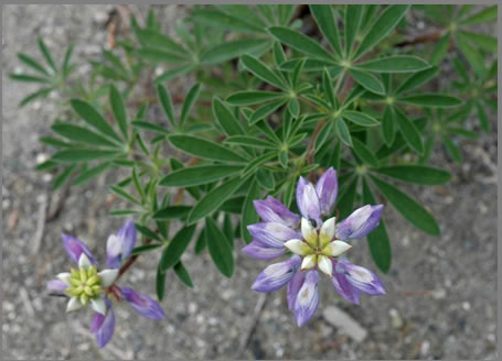
Streambank lupine (Lupinus rivularis) is a herbaceous plant that ranges in height from 0.3 to 1.0 m (Riggins and Sholars 1993; Kozloff 2005). Although considered a perennial, it appears to be relatively short-lived (often 3–5 years). Its hollow stems are green to reddish-brown, and are smooth or slightly hairy and branched. Older stems are occasionally slightly woody at the base. Leaves are alternately arranged along the stems and mature plants lack basal leaves. Each leaf is palmately compound with 5 to 9 leaflets, most of which are up to 3.5 cm long. The leaflets are short-hairy on their undersides. The petioles or leaf stalks are relatively short, usually less than 4 cm. Streambank lupine usually flowers from May into June. Its showy inflorescence is composed of a terminal raceme with several well-separated whorls of flowers that are mostly blue-purple to lavender. The banners (upper petals) are about the same length as the wings (side petals) and keel (lower petal). Flowers are hairless except for the keel, which is finely fringed with hairs along its upper edges. Its seedpods are about 5 cm long, and minutely hairy and dark- or black-mottled when mature. In B.C., seeds appear to germinate throughout the year when conditions are favourable.
The distributions of two native lupines may overlap with the range of streambank lupine in southwestern B.C. Most similar is broadleaf lupine (Lupinus latifolius var. latifolius), a species that grows in similar habitats but at higher elevations and more inland. Broadleaf lupine was not listed for B.C. before 2001 (B.C. Conservation Data Centre 2013), although it has a natural and widespread distribution here. Broadleaf lupine is distinguished from streambank lupine by its longer leaf petioles and the placement of short hairs on the keels of the flowers. Broadleaf lupine has cilia from the claw at the base to near the middle of the keel, whereas the cilia of streambank lupine are positioned near the tip of the keel. Seashore lupine (Lupinus littoralis) is distinguished from streambank lupine by its long-hairy stems, a prostrate growth habit, and longer petioles. This species is found in B.C.; however, it is found in moist, coastal sand dune communities (Douglas et al. 1999).
Other species of perennial lupines grow within the range of streambank lupine, most commonly large-leaved lupine (Lupinus polyphyllus ssp. polyphyllus), a frequently seeded, possibly native, species along highway right-of-ways in southwestern B.C. It is distinguished from streambank lupine by its larger, tighter flower clusters; larger and more numerous leaflets; and longer petioles. Tree lupine (Lupinus arboreus), an introduced species, has been reported from the Lower Mainland region but has not been observed near streambank lupine populations. Its flower petals are yellow and its stems are usually woody in mature plants. Undetermined species or possible hybrids with streambank lupine exist in the Vancouver area. A hybrid or distinct and undetermined species (C. Björk, pers. comm., 2011) occurs with streambank lupine at one site (Population 4, Blundell). This taxon is characterized by long-hairy stems, a more prostrate growth habit, and often longer petioles than streambank lupine.
Streambank lupine is a western North American endemic, found along the Pacific coast from B.C. to northern California (Figure 1; Riggins and Sholars 1993). In Canada, streambank lupine is restricted to extreme southwestern B.C. with all but one population (near Sooke on Vancouver Island) found within the Lower Mainland region.
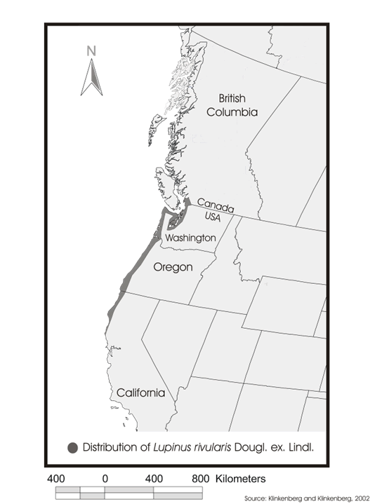
Long description for Figure 1
Figure 1 is a map of the distribution of streambank lupine in western North America. It is found along the Pacific coast from extreme southwestern British Columbia to northern California. One more population is found near Souke on Vancouver Island.
In B.C., there are 8 populationsFootnote2 of streambank lupine, known from 14 reported sites (subpopulations) (Figure 2; Table 1). It was first reported in B.C. in 1926 from near Sooke on Vancouver Island, based on collections at the Royal British Columbia Museum (RBCM) in Victoria. The remaining Lower Mainland populations have been reported since 1988, with the most recent discovered in 2013 (Population 8; Figure 2).
A lupine record from the Cowichan area on Vancouver Island (through photographs from 2007) has been tentatively identified as streambank lupine. This identification needs to be confirmed as it potentially represents a new population. Further, a collection of streambank lupine at the RBCM (V007854B) collected near Comox in 1931 needs to be examined again and its identification confirmed.
There is a 1926 historical herbarium record from the Sooke area. Although there were also reports from this area in 2001, 2006, and 2007, examination of photographs showed that these plants were not streambank lupine but probably broadleaf lupine. This site is considered historical; however, as this is a relatively large area with suitable habitat, it is possible that streambank lupine may still be found and more inventory is required.
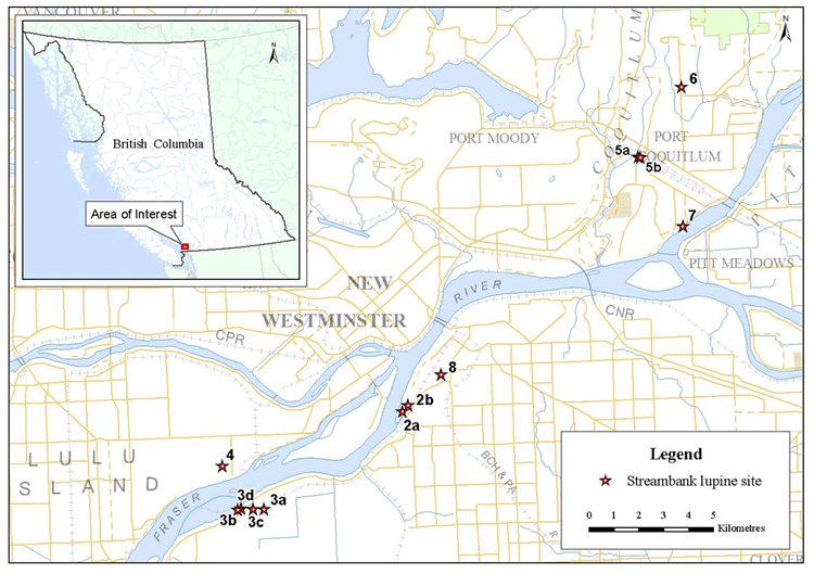
Long description for Figure 2
Figure 2 displays a map of the 14 sites of 7 streambank lupine populations in the lower Mainland area of southwestern British Columbia. Population 2 has 2 site locations; 1 on Alaska way in Delta, and 1 on Elevator Road in Surrey. Population 3 has 2 site locations on Burlington Northern Santa Fe Railway and 2 in Chatterton in Delta. Site location of population 4 is in Blundell in Richmond close to the Fraser River. Locations of population 5 are on Kingsway South and Kingsway North in Port Coquitlam. Site locations of population 6 is on Watkins Creek in Coquitlam, population 7 is in Pitt River Dyke in Port Coquitlam, and population 8 on Grace Road in Surrey.
| Population # with subpopulation descriptor and statusFootnoteh | Site name | Counts | Habitat | Land ownership |
|---|---|---|---|---|
| 1 Historical (COSEWIC #1) |
Sooke, Vancouver Island | 1926: Historical (herbarium record) 2001; 2006–2008Footnotei: 0 |
Coarse gravel, cobble (river bar) | Provincial Crown |
| 2a Extant (COSEWIC # 3) |
Delta: Alaska Way |
2001: 50 flowering plants; > 100 seedlings/juveniles 2005: > 500 seedlings/juveniles 2009: 10 flowering plants; 51 seedlings/juveniles 2010: 2 flowering plants; 24 seedlings/juveniles 2011: 2 flowering plants; 49 seedlings/juveniles 2012: Outside fence near road: 5 flowering plants; 6 seedlings/juveniles Inside fence near tracks and piled lumber: ~25 flowering plants; ~> 66 seedlings/juveniles 2013: Outside fence near road: 4 flowering plants; 28 seedlings/juveniles Inside fence near tracks and piled lumber: ~70 flowering plants; ~>100 seedlings/juveniles |
Coarse gravel, silt, and sand (roadside) | Port Metro Vancouver; Corporation of Delta |
| 2b Extant | Surrey: Elevator Road | 2008: 1 plant 2009: 3 seedlings/juveniles 2010: 13 seedlings/juveniles 2013: 1 seedling/juvenile |
Silt and sand | Port Metro Vancouver |
| 2c Extirpated (COSEWIC #4) |
Surrey | 1992: present 2001: 32 flowering plants; > 30 seedlings/juveniles 2004: extirpated |
Coarse gravel and silt, sand (railway and ROWFootnotej) | Port Metro Vancouver |
| 3a Extant | Delta: BNSFFootnotek |
2008: present 2010: 6 flowering plants; ~600 seedlings/juveniles 2012: 3 seedlings/1 juvenile |
Coarse gravel (railway and ROW) | BNSF Railway |
| 3b Extant (COSEWIC #2) |
Delta: BNSF/80th St. | 1988: present 2001: 45 flowering plants; > 100 seedlings/juveniles 2002: 12 flowering plants; >24 seedlings/juveniles 2005: 41 flowering plants; > 100 seedlings/juveniles 2008: 20 flowering plants; > 200 seedlings/juveniles 2010: 46 flowering plants; 78 seedlings/juveniles 2012: > 40 flowering plants; > 60 seedlings/juveniles |
Coarse gravel and silt, sand (railway and ROW) | BNSF Railway, Corporation of Delta |
| 3c Extant | Delta: Chatterton | 2005: 45 flowering plants; > 45 seedlings/juveniles 2009: 20 flowering plants; 86 seedlings/juveniles 2010: 13 flowering plants; 14 seedlings/juveniles 2011–2012: > 60 flowering plants > 100 seedlings |
Coarse gravel and silt, sand (railway, railway and hydro ROWs and developed site) | BNSF, BC Hydro, Corporation of Delta; Private |
| 3d Extant | Delta: West of Chatterton |
2005: present 2009: 43 flowering plants; 10 seedlings/juveniles 2010: 93 flowering plants; 17 seedlings/juveniles 2011–2012: > 30 flowering plants > 50 seedlings |
Coarse gravel and silt, sand (railway and ROW) | BNSF Railway, Corporation of Delta |
| 4 Extant | Richmond: Blundell | 2007: 7 plants; > 12 seedlings/juveniles 2009: 134 flowering plants; 156 seedlings/juveniles 2010: extant 2013: 10 flowering plants; > 200 seedlings/juveniles |
Coarse gravel and silt, sand (roadside and railway ROW) | Canadian Pacific Railway; City of Richmond |
| 5a Extant | Port Coquitlam: Kingsway south | 2005: 0 2009: many flowering plants; many seedlings/juveniles 2010: ~350 flowering plants; ~150 seedlings/juveniles 2013: > 100 flowering plants; > 100 seedlings/juveniles |
Sand and silt (roadside partly within fenced area) | City of Port Coquitlam |
| 5b Extant (COSEWIC # 6) |
Port Coquitlam: Kingsway north | 1993: present 2001: 100 flowering plants; > 200 seedlings/juveniles 2009: 0 2010: 6 flowering plants; 34 seedlings/juveniles 2013: 7 flowering plants; 16 seedlings/juveniles |
Coarse gravel, sand and silt (roadside and railway ROW) | Canadian Pacific Railway; City of Port Coquitlam |
| 6 Possibly Extirpated | Coquitlam: Watkins Creek | 2008: 1 plant 2009: 1 plant; 10 seedlings/juveniles 2010: 2 flowering plants; 4 juveniles with no evidence of flowering or seedpods 2013: 0 |
2010: Coarse gravel, cobbles, rip rap (creek bank) 2013: heavy growth of tall vegetation since 2010 (grasses and shrubs; no open areas remain) |
City of Coquitlam |
| 7 Extant (COSEWIC #5) |
Port Coquitlam: Pitt River Dyke | 1993: present 2001: 20 flowering plants; 100 seedlings/juveniles 2009: 3 flowering plants; 14 seedlings/juveniles 2010: 17 flowering plants; 8 seedlings/juveniles 2013: 50 seedlings/juveniles |
Coarse gravel (river bank, dyke top) | City of Port Coquitlam; Private |
| 8 Extant | Surrey : Grace Road | 2013: ~8 flowering plants > 20 seedlings/juveniles |
Sandy-gravelly soil between sidewalk and concrete bridge edge | City of Surrey |
Across its North American range, streambank lupine naturally occupies open, nutrient-poor, sandy or gravelly, river or creek bank sites at low elevations proximal to the coast, generally having little competitive ground cover (COSEWIC 2002). These habitats are usually prone to flooding and are frequently scoured and modified. As such streambank lupine may use highly disturbed habitat for annual colonization to avoid competitive exclusion of other plants. In B.C., except for possibly the Sooke site, most floodplain habitats where streambank lupine is now found have been highly disturbed or completely altered by human activities. Most sites are completely artificial (human-made; S. Letay, pers. comm., 2013). Widespread dyking in the Lower Mainland has eliminated most natural flood-related disturbance regimes in the area. Typical habitats where this species survives today include railway right of ways (ROWs), roadside edges, open industrial sites, and dykes, many of which are frequently cleared of vegetation or disturbed in other ways. Some of these sites are open and mostly free of significant associated plant cover, but most of the sites house a wide variety of competitive exotic species. In B.C., streambank lupine occurs in the Coastal Douglas-fir and the Western Hemlock biogeoclimatic zones.
At present, the specific soil components required for streambank lupine are unknown. However, seeds of streambank lupine readily germinate and grow in various soil types ranging from sand to commercial garden soil (T. McIntosh, pers. comm., 2013). Also, some lupine species have relationships with mycorrhizal fungi. O’Dell and Trappe (1992) could not be certain if streambank lupine was mycorrhizal or not.
Little information specific to the reproductive biology of streambank lupine is available, but it is suspected that it, like many other perennial lupine species, is capable of both self-pollination and cross-pollination (COSEWIC 2002). Seed production is common in all of the B.C. populations.
Several factors may limit the survival and recovery of streambank lupine in B.C. including:
- The requirement for frequently disturbed habitats naturally associated with riverine systems, most of which have been lost or damaged by habitat conversion along the coast.
- The lack of special structures to aid in the long distance dispersal of seeds or fruits.
- The isolated occurrences and extremely small number of plants noted at many sites may limit reproductive success.
- The small and fragmented population sizes may subject the population to decreased genetic diversity and population viability.
- Small areas of occupancy leave this species susceptible to chance destructive events including those that operate at a small scale.
- The dependence on seasonal flooding for seed dispersal.
hreats are defined as the proximate activities or processes that have caused, are causing, or may cause in the future the destruction, degradation, and/or impairment of the entity being assessed (population, species, community, or ecosystem) in the area of interest (global, national, or subnational) (Salafsky et al. 2008). For purposes of threat assessment, only present and future threats are considered.Footnote3 Threats do not include limiting factors, which are presented in Section 3.4.Footnote4
For the most part, threats are related to human activities, but they can be natural. The impact of human activity may be direct (e.g., destruction of habitat) or indirect (e.g., invasive species introduction). Effects of natural phenomena (e.g., fire, hurricane, flooding) may be especially important when the species or ecosystem is concentrated in one location or has few occurrences, which may be a result of human activity (Master et al. 2009). As such, natural phenomena are included in the definition of a threat, though they should be applied cautiously. These stochastic events should only be considered a threat if a species or habitat is damaged from other threats and has lost its resilience, and is thus vulnerable to the disturbance (Salafsky et al. 2008) such that these types of events would have a disproportionately large effect on the population/ecosystem compared to the effect it would have had historically
The threat classification below is based on the IUCN-CMP (World Conservation Union–Conservation Measures Partnership) unified threats classification system and is consistent with methods used by the B.C. Conservation Data Centre and the B.C. Conservation Framework. For a detailed description of the threat classification system, see the CMP website (CMP 2010). Threats may be observed, inferred or projected to occur in the near term. Threats are characterized here in terms of scope, severity, and timing. Threat “impact” is calculated from scope and severity. For information on how the values are assigned, see Master et al. [PDF] (2009) and table footnotes for details. Threats for the streambank lupine were assessed for the entire province (Table 2).
| Threat #Footnotel | Threat description | ImpactFootnotem | ScopeFootnoten | SeverityFootnoteo | Timinge | Population(s) / SubpopulationsFootnotep |
|---|---|---|---|---|---|---|
| 1 | Residential & commercial development | Negligible | Negligible | Not scored | High | |
| 1.2 | • Commercial & industrial areas | Negligible | Negligible | Not scored | High | 2b; 3c; 7 |
| 4 | Transportation & service corridors | Negligible | Negligible | Extreme | Moderate | |
| 4.1 | • Roads & railroads | Negligible | Negligible | Extreme | Moderate | 2a, 2b |
| 5 | Biological resource use | Low | Small | Slight | High | |
| 5.2 | • Gathering terrestrial plants | Low | Small | Slight | High | Possible at all sites; likely only at a few |
| 6 | Human intrusions and disturbances | Negligible | Small | Negligible | High | |
| 6.1 | • Recreational activities | Negligible | Small | Negligible | High | 2a; 5a;5b; 7; 8 |
| 7 | Natural system modifications | Medium | Pervasive | Moderate | High | |
| 7.2 | • Dams & water management/use | Not calculated | Negligible | Not Scored | Insignificant | None |
| 7.3 | • Other ecosystem modifications | Medium | Pervasive | Moderate | High | 2a; 3a, 3b, 3c, 3d; 4; 5a, 5b; 7; 8 |
| 8 | Invasive & other problematic species & genes | High | Pervasive | Serious | High | |
| 8.1 | • Invasive non-native/alien species | High | Pervasive | Serious | High | All |
| 8.2 | • Problematic native species | Low | Small | Serious | High | All |
| 8.3 | • Introduced genetic material | Low | Small | Moderate | Moderate | 4 |
| 9 | Pollution | Medium | Large | Moderate | High | |
| 9.3 | • Agricultural & forestry effluents | Medium | Large | Moderate | High | 2a; 3a, 3b, 3c, 3d; 4; 5b, 7; 8 |
| 9.4 | • Garbage & solid waste | Low | Small | Slight | High | 2a |
| 11 | Climate change & severe weather | Not Calculated | Pervasive | Unknown | Low | All |
| 11.2 | • Drought | Not Calculated | Pervasive | Unknown | Low | All |
The overall province-wide Threat Impact for this species is Very High.Footnote5 The greatest threat is invasive non-native/alien species (Table 2). Details are discussed under the IUCN level 1 headings.
1.2 Commercial & industrial areas
Residential and commercial development has greatly impacted streambank lupine in the past. Residential development is unlikely to affect populations in future, however, given the locations of populations near commercial sites or railway right-of-ways. In 2004, Site 2c for streambank lupine was eliminated by building construction and paving. A portion of Site 2b was destroyed by construction of a parking area. Further, a 2007 upgrade of the surface of a dyke top trail along the Pitt River (Population 7) destroyed some individuals of streambank lupine. In 2010, 5–10% of mature plants were destroyed at subpopulation 3c, in preparation for a construction project. In the latter case construction was halted and a monitoring program was designed to protect the remaining streambank lupines and their habitat from further damage while construction was completed. Commercial and industrial development is not expected to be a significant threat to streambank lupine in the next 10 years.
4.1 Roads & railroads
Many populations of streambank lupine occur within railway right-of-ways or roadside edges and one subpopulation lies within a hydro right-of-way. Subpopulations 5a and 5b were partially destroyed through road expansion. Although expansion of roads at a few sites is possible, there are no current plans for expansion. This threat should be monitored as it is likely that if a project went forward, it could result in a significant amount of streambank lupine habitat being lost.
5.2 Gathering terrestrial plants
Because streambank lupine is an attractive plant with showy flowers, some Lower Mainland populations have been subject to flower, seed, and whole plant collecting (R. Klinkenberg, pers. comm., 2005; D. Hanna, pers. comm., 2012). The implications of loss from harvesting seed from rare wild populations have been addressed (Guerrant et al. 2004; Menges et al. 2004). Removal of seeds and the potential seedling cohort from small populations of rare plants may place these populations at greater risk of extirpation. Although collecting could occur at all sites, it is not likely to occur at more than a few sites in the next 10 years, if at all based on known previous collecting. It is expected that collecting would be no more than a few flowers or seeds at any one site and so is thought to have a low impact.
6.1 Recreational activities
Several streambank lupine populations occur in areas easily accessed by people. Plants may be trampled by walkers or damaged by vehicle parking; however, the number of individual plants affected is thought to be negligible.
7.2 Dams & water management/use
In the Lower Mainland portion of its B.C. range, suitable natural riverbank and floodplain habitat for streambank lupine has been significantly reduced by extensive development. As well natural disturbance regimes such as flooding and channel movement have been altered. This likely resulted in the loss of streambank lupine sites in the past. However this is considered a past threat as it is not likely that there will be any new construction and upgrading of dykes in the next 10 years that will threaten current sites.
7.3 Other ecosystem modifications
As many populations of streambank lupine occur within right-of-ways, maintenance activities including mowing and brushing occur at most sites. Depending on frequency and scheduling, these activities may damage or kill plants and disturb the habitat either by damaging the soil surface or covering the ground with litter.
8.1 Invasive non-native/alien species, 8.2 Problematic native species
Recovery team members and volunteers have removed invasive plants at some locations because of potential impacts on the streambank lupine. Because most of the introduced species are fast growing, they have the potential to physically overwhelm streambank lupine. As well, these species are mostly prolific seed producers and thus have the potential to outcompete streambank lupine seedlings for water and nutrients. Exotic species that are present at most sites where streambank lupine is found include Himalayan blackberry (Rubus armeniacus), Scotch broom (Cytisus scoparius), common tansy (Tanacetum vulgare), and species of vetch (Vicia spp.). Also, because streambank lupine prefers open habitats, trees such as the native black cottonwood (Populus trichocarpa) and the exotic white poplar (Populus alba) are colonizing the sites, thereby shading out streambank lupine.
8.3 Introduced genetic material
Genetic “swamping” through hybridization with other lupines, in particular the introduced tree lupine, was identified as a threat to streambank lupine throughout its range in southern B.C. by COSEWIC (2002). This species could become a problem in B.C. since it does occur in the Lower Mainland. However, it has not been observed near streambank lupine populations. Steps have been taken in the United States to remove tree lupine from some sites (Wozniak 2000). Other lupines, including the unidentified, hairy-stemmed lupine that is similar in many respects to streambank lupine, have been observed in a few sites in the Lower Mainland, most importantly Population 4 (Blundell).
9.3 Agricultural & forestry effluents
Many populations of streambank lupine occur within railway right-of-ways or roadside edges. Maintenance of these areas sometimes involves herbicide spraying as a method of weed control. Spraying has occurred at a few sites in the past and may be used at these same sites and others in future. The use of herbicides has decreased or ceased at sites where several subpopulations occur (e.g., 3a, 3b, 3c, 3d, and 7). Participation by local governments and railway companies has resulted in no spray zones at locations where this species grows. Signs indicating “No Spray” zones have been erected at one site.
9.4 Garbage & solid waste
Many streambank lupine populations occur in areas easily accessed by people. Debris left by people can alter, destroy, or disturb the habitat. Threats to extant populations include dumping (sand/gravel fill) and general garbage left by people using the area. In 2004, a portion of a site at Alaska Way (affecting subpopulation 2a) was removed and covered with gravel fill.
11.2 Drought
The impacts of climate change on streambank lupine are unknown. However, climate change does pose a potentially significant threat because, as Gayton (2008) notes, the species most vulnerable to extinction will be those with small populations, slow rates of dispersal, restrictive elevation and climate requirements, and/or those whose habitat is limited or occurs in patches. There is potential for streambank lupine populations to be affected by climate change and projected trends (i.e., warmer and drier summers, and reduced summer soil moisture within the species’ range). It is impossible to speculate on the effects that increased winter rainfall and more extreme weather events, as is predicted for coastal B.C., will have on the plant, habitats, and associated pollinator species.
The population and distribution goal for streambank lupine is to maintain the abundance of all known extant populations as well as any other extant populations that may be identified or established at a later date within the species’ known and potential range. If feasible and where deemed necessary, augment existing populations in B.C.
There is a lack of information about the historical abundance and distribution of streambank lupine. Aside from the one extirpated site (subpopulation 2c) and 1 historical site (population 1) there is no direct evidence that this species was previously more abundant or widespread in southwestern B.C. However, there has been substantial disturbance and alteration of the habitat in which the species is currently found. Therefore, it is reasonable to infer that this species probably existed at more sites and/or with larger population sizes in the past. Since habitat that has been destroyed by development will not be restored to historical levels or conditions, restoration at these extirpated sites is not technically feasible.
The recovery objectives for streambank lupine are:
- Secure long-term protectionFootnote6 for extant populations and habitats of streambank lupine in B.C.
- Confirm distribution within the known range of the species in B.C.
- Address knowledge gaps relating to species’ biology, habitat requirements, and population demography, and disturbance dynamics.
- Clarify and mitigate threats to this species and its habitat including invasive plants, plant succession, and hybridization.
- Determine feasibility of augmenting existing populations.
The following actions have been categorized by the action groups of the B.C. Conservation Framework (B.C. Ministry of Environment 2010). Status of the action group for this species is given in parentheses.
- COSEWIC status report completed (COSEWIC 2002).
- Streambank lupine assessed as Endangered (November 2002).
- B.C. Recovery Plan completed (this document, 2013).
- Mapping and inventory of lupines at all Lower Mainland locations from 2009 to 2013.
- A reconnaissance for new streambank lupine was conducted via boat in the Pitt River area in 2006, 2007, 2008, 2009, and 2010; via boat along Fraser River from Pitt Meadows west to Delta; and on the lower Gold Creek in Maple Ridge by recovery team members in 2009.
- Contact and continuing engagement with all stakeholders by the recovery team since 2005. An educational brochure was developed in 2006 (updates are now needed).
- Population stabilization methods, with guidance by the recovery team, are underway for lower Fraser Valley populations in cooperation with stakeholders and landowners, including site maintenance mitigation activities, vegetation management guidelines, fencing, parking lot barriers, signage, and site mapping.
- No brushing zones established in 2007 at two Port Coquitlam sites (Pitt River Dyke, 7 and Kingsway North, 5b).
- “Endangered Species Live Here” notice signs were erected at Port Coquitlam sites 5a and 5b and also at Delta site 2a in 2009.
- Invasive plant removal by recovery team members in 2008 and 2009 at a Delta site (Alaska Way, 2a); in 2009 at Richmond (Blundell, 4); in 2010 at Coquitlam (Watkins Creek, 6), Richmond (Blundell, 4) and Delta (Chatterton, 3c); in 2012 at Delta (Chatterton, 3c and 3d).
- Invasive plant removals were undertaken by the landowner at Coquitlam (Watkins Creek, 6). However, this population is now extirpated. Part of it has been overgrown and the other portion destroyed by housing development. In 2008, a planting plan for riparian restoration was tailored to avoid competition with streambank lupine, and a gravel/cobble bench was constructed to increase potential streambank lupine habitat at that site.
- Invasive plant removals were undertaken by volunteers under the direction of a recovery team member at Delta (Alaska Way, 2a) and Port Coquitlam (Port Coquitlam Kingsway south 5a) sites in 2010.
- In 2010, attempts were made to rescue a number of mature dying plants from the Chatterton site (3C) in Delta after being damaged in preparation for a construction project. Plants were gathered and taken to VanDusen Gardens but none survived. Construction was halted and a monitoring program was designed to protect the remaining lupines and their habitat from further damage while construction was completed. An environmental management consultant worked with the recovery team to identify mitigation options, resulting in translocation of seedbank soils and avoidance to impacts on existing streambank lupine plants at the Chatterton site (#3c).
- A 200-m no-spray zone on the Burlington Northern Santa Fe (BNSF) railway track was established in 2008 by the BNSF Railway company in Delta from the BNSF site (3a) west of the Chatterton site (3c and 3d) in response to maps the recovery team provided. BNSF Railway company has also agreed to restrict mowing in the area until after lupine seed set. BNSF Railway employees continue to assist the recovery team with reconnaissance surveys for new streambank lupine populations.
- Members of the recovery team met with staff from Metro Vancouver Regional Parks in 2011 to set up a trial for translocation of seeds to a suitable site at Deas Island Regional Park, a protected area about 4 km west of Population 3. Seeds have germinated and mature flowering plants are present in 2013 (T. McIntosh, pers. comm., 2013)
| Conservation Framework action group | Obj. # | Actions to meet objectives | ThreatFootnoteq or concern addressed | PriorityFootnoter |
|---|---|---|---|---|
| Habitat Protection & Restoration; Land Stewardship | 1 | Identify and contact landowners and land managers and engage their cooperation to steward and manage lands for persistence of the species. Educate about where streambank lupine is located on their lands and encourage to manage lands for the persistence of the species. | 1.2; 5.2; 6.1; 7.3; 8.1; 8.2; 9.3; 9.4 | Essential |
| Habitat Protection & Restoration; Land Stewardship | 1, 4 | Develop and implement best management practices for mitigating threats. | 1.2; 6.1; 7.3; 8.1; 8.2; 9.3; 9.4 | Essential |
| Habitat Protection & Restoration; Land Stewardship | 1, 4 | Develop and implement site management plans for each population of streambank lupine to address threats. | All | Essential |
| Habitat Protection & Restoration; Land Stewardship | 1 | Determine appropriate protection mechanisms (e.g., stewardship agreements) for each site. | All | Essential |
| Habitat Protection & Restoration; Land Stewardship | 2, 5 | Inventory potential habitats to confirm distribution of the species and availability of potential sites suitable for establishing new populations. | Knowledge gaps | Beneficial |
| Habitat Protection & Restoration; Land Stewardship | 2 | Confirm identification of any reported lupines (e.g., plants from Cowichan area on Vancouver Island; specimen in RBCM collected near Comox in 1931). | Knowledge gaps | Essential |
| Habitat Protection & Restoration; Land Stewardship | 3 | Design a monitoring program to determine population trends. | Knowledge gaps | Necessary |
| Habitat Protection & Restoration; Land Stewardship | 4 | Investigate the impacts of invasive species and vegetation succession. | 8.1; 8.2 | Necessary |
| Species and Population Management | 3 | Develop a prioritized research strategy, including costs and partnerships to address knowledge gaps. | Knowledge gaps | Beneficial |
| Species and Population Management | 3 | Conduct and encourage research to: | Knowledge gaps | - |
| Species and Population Management | 3 | • Study population demography to determine recruitment levels and demographic features, including longevity of plants; | Knowledge gaps | Necessary |
| Species and Population Management | 3 | • determine specific habitat requirements and other ecological factors; | Knowledge gaps | Beneficial |
| Species and Population Management | 3 | • determine disturbance dynamics, to develop an understanding of anthropogenic sites versus natural conditions and to determine threshold levels for anthropogenic disturbance; | Knowledge gaps | Beneficial |
| Species and Population Management | 3 | • investigate seed production, seed bank germination rates and longevity, seed dispersal mechanisms, seedling and juvenile development; and | Knowledge gaps | Beneficial |
| Species and Population Management | 3 | • investigate genetic profile of local populations, and determine genetic status and, if possible, fitness. | Knowledge gaps | Beneficial |
| Species and Population Management | 4 | Work cooperatively with the Invasive Species Council of B.C. and the provincial government to develop an eradication program. | 8.1 | Beneficial |
| Species and Population Management | 4 | Work with the federal government to restrict the import, use and sale of plants and seeds of tree lupine. | 8.1 | Beneficial |
| Species and Population Management | 4 | If genetic research warrants, implement outreach program to create awareness of impacts of imported lupines on local native lupines | 8.2; 8.3 | Beneficial |
| Species and Population Management | 4 | Develop materials to educate various groups (e.g., recreation groups, gardening groups) and individuals about streambank lupine, its needs, the threats it faces from seed collecting and importing exotic species, and what can be done to help the species persist. | 5.2; 6.1; 7.3; 8.1; 8.2; 9.3; 9.4 | Beneficial |
| Species and Population Management | 5 | Develop protocols to determine the feasibility of augmentation:
If feasible, use results of habitat and ecological research to assess potential for sites to establish new populations. |
Knowledge gaps | Beneficial |
6.3.1 Habitat Protection and Private Land Stewardship
It is essential to secure long-term habitat protection for known populations of streambank lupine. This can be achieved by continuing to inform landowners and land managers of its location on their property and of the needs of this species. Ongoing invitations to landowners to participate in recovery planning and encouraging them to develop stewardship agreements will benefit the persistence of streambank lupine. Developing appropriate protection mechanisms, including stewardship agreements, and developing and implementing site management plans and best management practices will continue to be important. Site management plans for each population of streambank lupine will include such things as invasive plant and succession control and protection from human disturbance, which may include fencing.
It is essential to monitor trends in each of the subpopulations, to address knowledge gaps in terms of population demographics, to assess the effects of threats to the subpopulations, and to evaluate the effectiveness of recovery actions. A standardized monitoring program conducted at regular intervals can contribute to a body of information on such things as recruitment levels, subpopulation cycles, and individual plant longevity. As well, a standardized monitoring program can help gauge the impacts and threats from such sources as introduced invasive plant species and from vegetation succession.
6.3.2 Species and Population Management
Further information is required on specific habitat requirements and other ecological factors affecting streambank lupine. Research towards a better understanding of disturbance dynamics will help manage existing sites in terms of determining disturbance threshold levels for anthropogenic sites.
Using the results of research into habitat requirements and ecology of streambank lupine will allow recovery team members to assess the potential for sites to establish new populations.
Currently, there is a lack of information about streambank lupine’s seed bank germination rates and longevity, seed dispersal mechanisms, and seedling and juvenile development. Research is needed to help develop protocols that would determine the feasibility of translocation of seeds to establish any needs for propagule treatment and site preparation.
Threats to streambank lupine habitat have been identified and habitat appears to be limiting for this species. To meet the population and distribution goal for this species, it is recommended that specific habitat attributes be identified for streambank lupine and locations of habitat are geospatially described on the landscape to facilitate management to mitigate habitat threats.
A general description of habitat requirements for streambank lupine in B.C. is provided in Section 3.3. Specific habitat requirements for the species and the relationship to regularly disturbed habitats still need to be determined. When this work has been completed, it would be beneficial if the habitat needed for survival/recovery of the species was spatially identified for streambank lupine in B.C. (see section 7.2).
A schedule of studies outlining the work necessary to identify survival/recovery habitat for streambank lupine is provided in Table 4.
| Description of activity | Outcome/rationale | Timeline |
|---|---|---|
1. Describe and record condition of occupied habitat.
|
Specific habitat required for the species are described to maintain, and/or where feasible, augment abundance of existing populations. | 2018 |
| 2. Identify and map occupied and potential habitat for streambank lupine. |
|
2018 |
The performance indicators presented below provide a way to define and measure progress toward achieving the population and distribution goal and recovery objectives. The overall indication that the recovery (population and distribution) goal is being met is if the population monitoring over an appropriate amount of time indicates that the annual numbers of flowering individuals at all locations are stable (e.g., fall within an acceptable range required for long-term persistence).Footnote7 Performance measures are listed below for each objective for the next 5 years.
Measurable(s) for Objective 1
- Five known extant sites have stewardship agreements by 2017.
Measurable(s) for Objective 2
- Population and habitat status at existing sites has been confirmed by 2015.
- Inventory of potential habitats has been conducted and documented by 2017.
Measurable(s) for Objective 3
- A prioritized research strategy has been developed by 2015.
- Priority research has been initiated by 2016.
- Trends in population and changes to area of occupancy (to the extent possible) have been assessed by 2018.
Measurable(s) for Objective 4
- Impact of threats to the populations has been investigated by 2015 and threat reduction and/or mitigation at all extant populations have been initiated by 2018.
Measurable(s) for Objective 5
- Research has been conducted to determine feasibility of augmenting populations by 2017.
No negative effects are anticipated on non-target species, natural communities or ecological processes as a result of the recommended recovery activities. Efforts undertaken to broaden support for the protection of streambank lupine should benefit all species at risk. Also, surveys to confirm existing and potential new populations of streambank lupine may have a positive effect by identifying additional locations for other species at risk. Species at risk that possibly overlap in the geographic range and occur in similar habitat as streambank lupine are the Pacific Water Shrew (Sorex bendirii; SARA-listed Endangered); Vancouver Island Beggarticks (Bidens amplissima; SARA-listed Special Concern, provincial Blue list), and Henderson’s checkermallow (Sidalcea hendersonii; provincial Blue list).
- B.C. Conservation Data Centre. 2013. BC Species and Ecosystems Explorer. B.C. Min. Environ., Victoria, BC. [Accessed May 23, 2012]
- B.C. Ministry of Environment. 2010. Conservation framework. B.C. Min. Environ., Victoria, BC. [Accessed May 23, 2012]
- Conservation Measures Partnership. 2010. Threats taxonomy. [Accessed May 23, 2012]
- Committee on the Status of Endangered Wildlife in Canada (COSEWIC). 2002. COSEWIC assessment and status report on the Streambank Lupine Lupinus rivularis in Canada. Ottawa, ON. vi + 36 pp.
- Douglas, G.W., D.V. Meidinger, and J. Pojar. 1999. Illustrated flora of British Columbia. Volume 3: Dicotyledons (Diapensiaceae through Onagraceae). B.C. Min. Environ., Lands and Parks and Ministry of Forests, Victoria, BC.
- Gayton, D. 2008. Impacts of climate change on British Columbia’s diversity: a literature review. Forrex Forest Research Extension Partnership [PDF; 877 KB], Kamloops, BC. Forrex Series 23. [Accessed May 23, 2012]
- Government of Canada. 2009. Species at Risk Act policies, overarching policy framework – draft [PDF; 644 KB]. Min. Environ., Ottawa, ON. 38 pp. [Accessed May 23, 2012]
- Guerrant, E.O. Jr., P.L. Fiedler, K. Havens, and M. Maunder. 2004. Revised genetic sampling guidelines for conservation collections of rare and endangered plants. In Guerrant, E.O. Jr., K. Havens, and M. Maunder. Ex-situ conservation: supporting species in the wild. Society for Ecological Restoration International, Centre for Plant Conservation. Island Press, London, ON.
- Kozloff, E.N. 2005. Plants of Western Oregon, Washington and British Columbia. Timber Press, Portland, OR.
- Master, L., D. Faber-Langendoen, R. Bittman, G.A. Hammerson, B. Heidel, J. Nichols, L. Ramsay, and A. Tomaino. 2009. NatureServe conservation status assessments: factors for assessing extinction risk. NatureServe, Arlington, VA. [Accessed May 23, 2012]
- Menges, E.S., E.O. Guerrant Jr., and S. Hamze. 2004. Effects of seed collecting on the extinction risk of perennial plants. In Guerrant, E.O. Jr., K. Havens, and M. Maunder.
- Ex-situ conservation: supporting species in the wild. Society for Ecological Restoration International, Centre for Plant Conservation. Island Press, London.
- NatureServe. 2004. A habitat-based strategy for delimiting plant element occurrences: guidance from the 2004 working group [PDF; 82.6 KB]. Arlington, VA. [Accessed January 24, 2011]
- NatureServe. 2012. NatureServe explorer: an online encyclopedia of life [web application]. Version 7.1. Arlington, VA. [Accessed January 27, 2010]
- O’Dell, T.E. and J.M. Trappe. 1992. Root endophytes of lupine and some other legumes in northwestern USA. New Phytol. 122(3):479–485.
- Province of British Columbia. 1982. Wildlife Act [RSBC 1996] c. 488. Queen’s Printer, Victoria, BC. [Accessed May 23, 2012]
- Province of British Columbia. 2002. Forest and Range Practices Act [RSBC 2002] c. 69. Queen’s Printer, Victoria, BC. [Accessed May 23, 2012]
- Province of British Columbia. 2008. Oil and Gas Activities Act [SBC 2008] c. 36. Queen’s Printer, Victoria, BC. [Accessed May 23, 2012]
- Riggins, R. and T. Sholars. 1993. Lupines. In Hickman, J.C. The Jepson Manual: higher plants of California. University of California Press.
- Salafsky, N., D. Salzer, A.J. Stattersfield, C. Hilton-Taylor, R. Neugarten, S.H.M. Butchart, B. Collen, N. Cox, L.L. Master, S. O’Connor, and D. Wilkie. 2008. A standard lexicon for biodiversity conservation: unified classifications of threats and actions. Conserv. Biol. 22:897–911.
- Wozniak, J. 2000. Reversing invasion of Lupinus arboreus (Yellow Bush Lupine), an invasive species of northern California sand dune communities. [Accessed April 2, 2004]
Curtis Björk, Botanist. Clearwater, BC. 2011.
Quentin Cronk, Ph.D., Director, University of British Columbia Botanical Garden. Vancouver, BC. 2005.
Dawn Hanna, Botanist. Vancouver, BC. 2011.
Rose Klinkenberg, Botanist. Richmond, BC. 2005.
Sylvia Letay, Ecosystems Officer, B.C. Ministry of Environment. 2013.
Terry McIntosh, Ph.D., Botanist, Vancouver, BC. 2013.