Fish habitat manipulation experiment at Turkey Lakes watershed
Rationale
The linkages between aquatic habitat and fish communities are not well understood, largely due to the near complete lack of rigorous testing. Management decisions regarding fish habitat conservation or destruction are not well supported by scientific evidence and therefore vulnerable to challenge. This study conducted by the DFOGLLFAS-SSM will provide scientific evidence of the nature and extent of the effects of habitat destruction on fish communities.
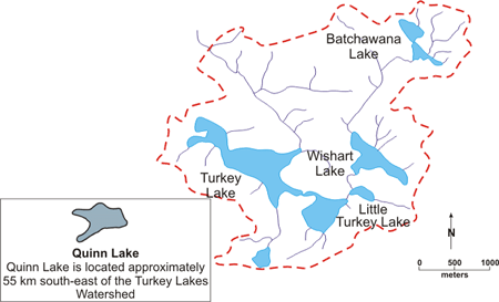
Figure 1: Long Description
Lakes used in the habitat manipulation experiment. Batchawana Lake is the control. Batchawana Lake is the control. Quinn Lake is located approximately 55km south-east of the Turkey Lakes Watershed
Hypotheses
This Project has been organized to address a hierarchy of hypotheses:
- Is there a change in the total fish biomass or production when habitat is altered?
- Is there a change in the interspecies allocation of biomass or production when habitat is altered?
- Is there a change in either the spatial or temporal intraspecies distribution when habitat is altered?
- Is there a change in the relative contribution of habitat features to either the spatial or temporal intraspecies distribution when habitat is altered?
- Are aquatic systems sustained when nearshore (diverse) habitat undergoes encroachment similar to development for cottage construction?
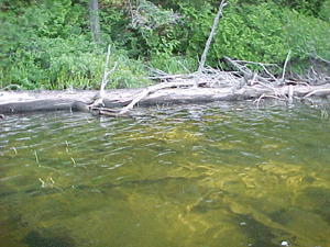
Figure 2: Typical appearance of shoreline and littoral zone in Wishart Lake prior to wood removal.
Treatment in Selected Lakes
To mimic human encroachment into aquatic ecosystems (e.g., changes to the littoral zone associated with cottage development), habitat diversity was decreased in Quinn Lake (located 55 km southeast of Turkey Lakes) and in Little Turkey Lake in 1999, and in Wishart Lake in 2000 (Figure 1). An example of typical pre-manipulation shoreline is shown in Figure 2. All nearshore vertical woody structure (coarse and fine woody debris in <2m depth water depth) was removed from 50% of the shoreline of Quinn and Little Turkey Lakes (Figures 3 and 4). In Little Turkey Lake, some of the same nearshore bottom substrate was covered with a water/gas permeable geotextile (Figure 5) to simulate the uniformity associated with beach sand. Habitat manipulation in Wishart Lake replicated Quinn Lake. Batchawana Lake remains unperturbed as a reference lake.
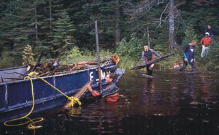
Figure 3: Removing wood from Quinn Lake
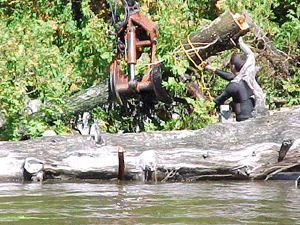
Figure 4: Long Description
Submerged log being removed from the littoral zone of Wishart Lake using a shore-based crane.
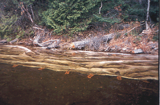
Figure 5: Long Description
Water/gas permeable geotextile covering the nearshore bottom substrate of a portion of shoreline in Little Turkey Lake where woody debris was removed. The geotextile simulates uniformity associated with beach sand.
Monitoring
The Project has included pre- and post-manipulation monitoring of resident biological populations and the physical and chemical characteristics of the lakes (by DFO-GLLFAS-SSM unless noted otherwise):
- Pre-manipulation mapping of all in-water habitat including macrophytes, sediment characteristics, woody debris, and overhanging vegetation.
- Fish abundance (mark-recapture), biomass, production, and community dynamics.
- Abundance and diversity of zooplankton, phytoplankton, and macroinvertebrates.
- Determination of changes in food web structure using stable isotope analysis (M. Whittle, DFO-GLLFAS, Burlington).
- Assessment of fish distribution in relation to habitat type using underwater video camera, transect swims, and location-specific catch data.
- Determination of species, age, volume, and surface area of woody debris (W. Cole, OMNR-OFRI).
- Sub-sampling of wood to determine biofilm-Chlorophyll-a content and invertebrate diversity and density.
- Measurements of dissolved oxygen, temperature, pH, nutrients, major ions, metals, and suspended sediment to determine changes associated with the manipulation (R. Semkin, NWRI).
- Continuous monitoring of water levels (R. Semkin, NWRI).
- Post-manipulation assessment of wood redistribution from uncleared areas into cleared areas.
- Tree mortality by species and age-class to determine the natural mortality rates of trees in the forest-lake ecotone, and natural log input rates into lakes (W. Cole, OMNR-OFRI).