Ice phenology at Turkey Lakes watershed
Why:
Long-term monitoring records collected during the Turkey Lakes Watershed (TLW) Study may hold information on ecosystem responses to climatic change. At its annual meeting in January 2000, EMAN initiated a call to evaluate the time of lake ice formation and break-up observed at participating sites. This kind of measure should integrate the effect of several climatic variables (e.g. air temperature, wind, solar radiation and/or degree of cloudiness, etc.).

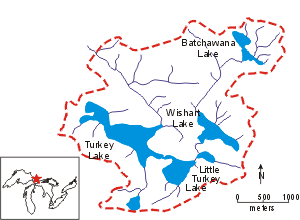
Figure 1: Location of TLW. Turkey Lake is the last and largest lake in the chain.
Where:
The TLW Study was initiated in 1980 to evaluate anthropogenic perturbation of Canadian Shield ecosystems. The basin is located in the Algoma District of central Ontario, ~50 km north of Sault Ste. Marie (Figure 1). It is completely forested (mixed hardwoods), 10.5 km2 in area, and contains a chain of 4 lakes (5 distinct lake basins) that ultimately drain into Lake Superior via the Batchawana River. Records of ice phenology have been maintained for all 5 lake basins. Information for Turkey Lake is presented here.
How:
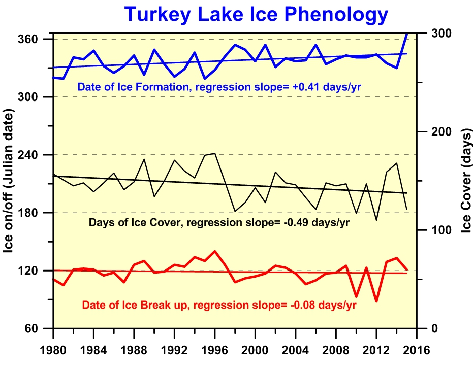
The date of ice formation and break-up has been recorded each year as part of the information needed to determine detailed water and chemical mass balances for the lakes and to determine when the ice provides a safe platform for winter sampling. Visits by field staff to the vicinity of the lakes to collect either lake or stream samples occurs at least weekly and as often as daily during spring melt. Ice status has been ascertained from the same viewing location(s) by the same individual (R. Neureuther) throughout the TLW Study, and the information is recorded in field notebooks. The inspection procedure is sufficiently rigorous that several cases of only partial and/or temporary ice coverage have been identified. The dates for Turkey Lake given in Figure 2 correspond to permanent, complete ice coverage in the fall and complete disappearance of ice in the spring. The dates have an error of at most ± 3 days.

Figure 2: Long Description
Julian Date (± 3 days) of spring ice break-up (thick red line) and fall ice formation (thick blue line) in Turkey Lake from 1980 to 2015. The thick black line shows the resulting days of ice cover. Associated thin solid lines are the linear regressions.
Results:
Positive regression slopes (thin solid lines in Figure 2) for the dates of ice break-up in the spring and particularly ice formation in the fall suggest that both are occurring later each year resulting in a decline (i.e. regression slope = -0.53 days/year) in the annual period of ice cover. Regressions for the date of ice formation and days of ice cover were statistically significant. Experience has shown that the 25-year period of record available from the TLW is still quite short for identifying systematic ecological trends, i.e. addition of 1 or 2 new data points may greatly influence the trend significance.
Contact: D.S. Jeffries