
Turkey Lakes watershed: forests
The Forest
The Turkey Lake Watershed is located within the Algoma section of the Great Lakes - St. Lawrence Forest Region. Forest composition and growth is monitored using a network of 0.10 ha permanent sample plots (PSPs) distributed across the watershed. The forest is composed of uneven-aged mature to overmature sugar maple forest (150 year old) with yellow birch, hop-hornbeam, red maple, white spruce and minor components of other species (Table 1). The official provincial tree of Ontario, the eastern white pine, is found sporadically at locations across the study site. On upland sites 90% of the basal area is sugar maple, 9% other hardwoods, and 1% conifer; on lowland sites the conifer proportion is greater. Site disturbance has been minimal with only a mid-1950’s logging operation of veneer/sawlog quality yellow birch and white pine. Stands regenerate naturally through gap dynamics and are in equilibrium (steady state) as far as above-ground net biomass accumulation. Gross growth is significant but mortality offsets growth gains.
|
Species |
Density
(Stems ha -1) |
Mean
dbh (cm) |
Mean
Height (m) |
Basal Area
(m 2 ha) |
Basal Area
(%) |
Total Volume
(m 3 ha -1) |
Biomass
(Mg ha -1) |
|---|---|---|---|---|---|---|---|
|
Sugar maple |
687
|
16.2
|
15.1
|
22.1
|
80.3
|
176.8
|
163.9
|
|
Yellow birch |
74
|
18.1
|
16.2
|
3.8
|
13.7
|
32.5
|
25.2
|
|
Hop- hornbeam |
37
|
11.1
|
15.0
|
0.4
|
1.5
|
2.6
|
2.2
|
|
Red maple |
15
|
14.8
|
14.9
|
0.4
|
1.3
|
2.7
|
2.7
|
|
White spruce |
11
|
16.7
|
12.5
|
0.3
|
1.1
|
2.4
|
1.5
|
|
Balsam fir |
10
|
9.6
|
8.7
|
0.1
|
0.3
|
0.5
|
0.3
|
|
White cedar |
6
|
19.6
|
12.6
|
0.3
|
1.2
|
2.6
|
2.2
|
|
White birch |
3
|
12.8
|
13.9
|
0.1
|
0.2
|
0.5
|
0.3
|
|
Red cherry |
1
|
16.8
|
16.4
|
0.1
|
0.1
|
0.1
|
0.1
|
|
Red oak |
1
|
33.0
|
19.1
|
0.1
|
0.3
|
0.6
|
0.5
|
|
Stand Totals
|
845
|
16.1
|
15.0
|
27.7
|
100
|
221.3
|
198.6
|
The majority of vegetation layer biomass at the Turkey Lakes Watershed occurs within the stem wood (55%) while less than 2% is accounted for by foliage (Table 2). Variation in element concentrations between tree components results in a disproportionate contribution to element pools in relation to biomass. For example, stem bark accounts for only 8% of the total vegetation biomass but 42% of the Ca content in all vegetation. High concentrations of N and K in sugar maple foliage result in element contents representing 16 and 13% of the total vegetation content, respectively, in spite of the small dry matter weight. While significant quantities of nutrients are immobilized in woody biomass at the site, there is the potential for conservation of overstory nutrients through partial harvesting systems and stem-only removal. Shelterwood and selection harvesting can increase nutrients retained in the trees left standing after harvest, and stem-only removal can increase the retention of logging residues such as branches and foliage which contain significant nutrient pools.
|
Stratum - Tree Layer
|
Biomass
|
N
|
P
|
K
|
Ca
|
Mg
|
S
|
Fe
|
Mn
|
Zn
|
Cu
|
|---|---|---|---|---|---|---|---|---|---|---|---|
| Foliage |
4176
|
94.5
|
4.2
|
46.5
|
33.0
|
5.1
|
9.5
|
0.3
|
3.9
|
0.30
|
0.04
|
| Live branch |
48439
|
167.8
|
10.7
|
138.9
|
332.2
|
14.3
|
17.4
|
2.4
|
14.4
|
1.57
|
0.18
|
| Dead branch |
1971
|
6.3
|
0.3
|
1.7
|
14.9
|
0.7
|
0.7
|
0.1
|
0.6
|
0.03
|
0.01
|
| Stem wood |
134955
|
129.8
|
8.8
|
81.7
|
132.3
|
19.4
|
11.9
|
2.4
|
9.7
|
1.77
|
0.48
|
| Stem bark |
19452
|
116.7
|
4.9
|
66.7
|
457.7
|
8.5
|
6.8
|
1.0
|
12.0
|
1.51
|
0.13
|
| Stump and roots |
35067
|
51.9
|
2.8
|
30.0
|
119.4
|
8.1
|
4.4
|
0.8
|
4.5
|
0.70
|
0.14
|
|
Total
|
244060
|
567.0
|
31.7
|
365.5
|
1079.5
|
56.1
|
50.7
|
7.0
|
45.1
|
5.88
|
0.98
|
|
Stratum - Lesser vegetation
|
Biomass | N | P | K | Ca | Mg | S | Fe | Mn | Zn | Cu |
| Woody species |
1125
|
11.4
|
0.7
|
3.8
|
7.9
|
0.9
|
0.3
|
0.2
|
0.6
|
0.06
|
0.04
|
| Nonwoody species |
115
|
3.1
|
0.2
|
1.8
|
0.9
|
0.2
|
0.2
|
0.1
|
0.1
|
0.01
|
0.01
|
|
Total
|
1280
|
14.5
|
0.9
|
5.6
|
8.8
|
1.1
|
0.5
|
0.3
|
0.6
|
0.07
|
0.05
|
|
Stand totals
|
245340
|
581.5
|
32.6
|
371.1
|
1088.1
|
57.2
|
51.2
|
7.3
|
45.7
|
5.95
|
1.03
|
The Soil
Soils at the Turkey Lakes Watershed have developed in a two component glacial till composed of a stony, silty-loam ablation till that overlies bedrock or a courser compacted, sandy basal till. The basal till is approximately 100 times less permeable than the ablation till. Soils are predominately podzolic with well developed organic horizons (LFH layers) and accumulation of organic matter (10%), Fe and Al in the B horizon. The pH of the mineral soil is 4.0 at the surface increasing to 5.5 at depth. The Turkey Lake site has high nitrification rates in the LFH horizons and upper mineral soil due to abundance of high quality sugar maple litter. Podzolization is most advanced on upland sites and least advanced in local depressions (Table 1). Upland sites have a high frequency of Ae horizons, deeper Bhf horizons and higher Fe and Al concentrations in B horizons. At lower slope locations Ah horizons are often present along with gleyed B horizons.
| Slope Position (%) | Horizon | Average depth (cm) | Frequencya (%) | pH H2O | N (%) | Organic matter (%) | Feb (%) | Alb (%) |
|---|---|---|---|---|---|---|---|---|
| Crest | Ae | 2.9 | 82 | 3.79 | 0.54 | 14.2 | - | - |
| Crest | Bhf1 | 8.0 | 100 | 4.16 | 0.50 | 13.4 | 6.5 | 2.6 |
| Crest | Bhf2 | 8.3 | 80 | 4.60 | 0.34 | 9.5 | 5.4 | 5.0 |
| Crest | Bf | 4.4 | 42 | 4.81 | 0.24 | 6.9 | 3.2 | 4.4 |
| Upper | Ae | 2.0 | 60 | 4.02 | 0.29 | 9.1 | 1.4 | 0.4 |
| Upper | Bhf1 | 6.8 | 100 | 4.38 | 0.39 | 13.5 | 6.0 | 2.1 |
| Upper | Bhf2 | 11.5 | 90 | 4.77 | 0.28 | 11.4 | 5.8 | 5.1 |
| Upper | Bf2 | 4.3 | 42 | 4.88 | 0.23 | 6.8 | 3.2 | 4.5 |
| Middle | Ae | 1.6 | 48 | 4.31 | 0.42 | 10.9 | 1.7 | 0.4 |
| Middle | Bhf | 8.4 | 98 | 4.67 | 0.36 | 10.7 | 4.1 | 1.7 |
| Middle | Bf1 | 9.7 | 80 | 5.00 | 0.29 | 7.0 | 4.1 | 3.7 |
| Middle | Bf2 | 6.3 | 66 | 5.18 | 0.20 | 5.4 | - | - |
| Lower | Ae | 0.7 | 28 | 4.54 | 0.28 | 7.0 | 1.3 | 0.7 |
| Lower | Ah | 0.9 | 16 | 5.45 | 0.95 | 20.0 | - | - |
| Lower | Bhf | 6.8 | 84 | 4.95 | 0.47 | 12.2 | 3.1 | 2.5 |
| Lower | Bg | 1.0 | 16 | 5.71 | 0.30 | 11.3 | 2.1 | 1.2 |
| Lower | Bf1 | 9.9 | 96 | 5.28 | 0.30 | 6.2 | 3.1 | 2.8 |
| Lower | Bf2 | 6.8 | 66 | 5.48 | 0.24 | 5.0 | 2.6 | 2.6 |
| Lower | Bf3 | 1.6 | 20 | 5.78 | 0.23 | 6.0 | 2.4 | 3.1 |
a (Sampling points surveyed with presence of horizon/total sampling points) X 100
b Dithionite-citrate-bicarbonate + ammonium oxalate + sodium pyrophosphate
Forested wetlands occupy up to 15% of the area of some subbasins within the Turkey Lakes Watershed. These wetland soils have deep deposits of humified material and larger reserves of C, N and S when contrasted to upland sites (Table 2). Production of N and S in soils sampled from upland and wetland locations within watershed 50 was determined by incubation in the laboratory at 20oC under different moisture conditions (Figure 1). Under drier conditions (.25 X 33 kPa moisture content) Of horizons in wetlands showed greater production of SO42- and total inorganic N than F horizons sampled from upland profiles. Rewetting of dried soils from 0-20 cm depth had no impact on SO42- production for upland sites; while wetland soils had production similar to that under field capacity (33 kPa) and drier conditions (.25 X 33 kPa). All wetland horizons had lower production of SO42- and total inorganic N when incubated under saturated moisture conditions (2 X 33 kPa). An increase in summer drought conditions due to climate change could have a dramatic affect on the chemical export from headwater streams with forested wetland areas. Whether these differences in terrestrial S and N production will impact downstream will also depend on the type and timing of hydrological linkage between the wetlands and the aquatic system.
| Horizon | Depth (cm) | pH | C (kg ha-1) | N (kg ha-1) | S (kg ha-1) |
|---|---|---|---|---|---|
| Upland | |||||
| L | 6-4 | 4.9 | 2921 | 116 | 9 |
| F | 4-1 | 5.2 | 10654 | 542 | 46 |
| H | 1-0 | 4.3 | 13165 | 827 | 61 |
| Ahe | 0-2 | 4.0 | 6929 | 639 | 46 |
| Bhf | 2-6 | 4.5 | 19272 | 1484 | 141 |
| Bf1 | 6-26 | 4.9 | 71414 | 4518 | 498 |
| Bf2 | 26-48 | 4.9 | 55665 | 2930 | 495 |
| Profile total | 180021 | 10968 | 1298 | ||
| Wetland | |||||
| Moss | 5-0 | 4.9 | 3241 | 155 | 18 |
| Of | 0-12 | 4.9 | 28242 | 1340 | 218 |
| Oh1 | 12-22 | 5.0 | 41949 | 2782 | 519 |
| Oh2 | 22-32 | 5.0 | 50563 | 3547 | 716 |
| Oh3 | 32-47 | 5.4 | 100307 | 5343 | 1369 |
| Profile total | 224302 | 13168 | 2839 |
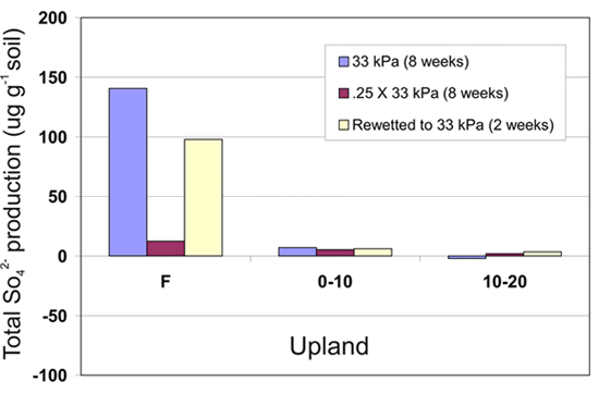


Figure 1. Sulfate and inorganic nitrogen production in upland and wetland soils.