
Report to Parliament 2015 to 2016: Canada Water Act: chapter 7
5. Ecosystem initiatives and ecosystem-based approaches
- 5.1. Great Lakes Ecosystem Initiative
- 5.2. St. Lawrence Action Plan
- 5.3. Atlantic Ecosystem Initiatives
- 5.4. Gulf of Maine
- 5.5. Pacific and Yukon Region
Federal and provincial governments have jointly developed and implemented basin-wide action plans in collaboration with communities and other stakeholders. These action plans are designed to help resolve complex environmental issues, particularly deteriorating water quality that threatens human and ecosystem health.
This section describes a number of key partnership-based ecosystem approaches through which Environment and Climate Change Canada (ECCC) works to ensure that Canadians have access to clean, safe and healthy water, and that the country’s water resources are used wisely, both economically and ecologically.
ECCC’s Ecosystem Initiatives are cooperative, place-based programs designed to deliver environmental results in targeted ecosystems. The objective of the Ecosystem Initiatives is to enhance or maintain ecosystem sustainability by addressing a range of local or regional environmental challenges through partnership-based work. Local activities are coordinated by ECCC and undertaken in collaboration with a range of local partners and stakeholders that may include other federal departments, provinces and territories, regional, municipal and local governments, Aboriginal peoples, federal and state governments in the United States, businesses, non-governmental and community organizations, and colleges and universities.
5.1. Great Lakes Ecosystem Initiative
The Great Lakes Ecosystem Initiative is a partnership of federal departments (Agriculture and Agri-Food Canada, ECCC, Fisheries and Oceans, Health Canada, Natural Resources Canada, Public Works and Government Services Canada, Transport Canada, and Housing, Infrastructure and Communities Canada) and one federal agency (the Parks Canada Agency).
The Great Lakes Ecosystem Initiative coordinates actions towards meeting Canada’s commitments under the 2012 Canada-U.S. Great Lakes Water Quality Agreement (GLWQA), and the 2014 Canada-Ontario Agreement on Great Lakes Water Quality and Ecosystem Health (COA). The GLWQA establishes broad, long-term objectives for Canada and the United States for restoring and protecting the Great Lakes, while the COA provides a short-term (five-year) plan for achieving Canada’s GLWQA commitments.
Areas of Concern
Areas of Concern (AOCs) are specific locations, such as harbours and embayments, where water quality and ecosystem health have been severely degraded by human activity at the local level. In 1987, Canada and the United States together designated 43 AOCs, 12 of which are in Canada, and 5 that are shared between Canada and the United States. In 2015-2016, coordination of Remedial Action Plan (RAP) activities in Great Lakes AOCs continued, including assessing and reporting on the success of past actions and on the status of remaining actions. Some examples of these activities are as follows:
- The decision on whether to delist the St. Lawrence River (Cornwall) AOC or to recognize it as an Area of Concern in Recovery is still pending. The St. Lawrence River Institute for Environmental Studies continued the study to assess shoreline sediment mercury concentrations which is expected to result in an updated contaminated sediment management plan for the river. The St. Lawrence River Restoration Council agreed to a review of the AOC delisting criteria to ensure that they are reasonable and achievable.
- The Bay of Quinte Remedial Action Plan (RAP) initiated assessments of the status of the degradation of fish and wildlife populations and degradation of fish and wildlife habitat beneficial uses. The RAP also finalized a Natural Heritage Strategy for the AOC and began to engage municipalities on its implementation.
- A significant milestone was achieved in the Toronto Region AOC with the re-designation of the Restrictions on Dredging Activities and Degradation of Benthos beneficial uses from “impaired” to “not impaired” status. This brings the total number of impaired beneficial uses in the AOC to six, down from ten five years ago.
- In the Hamilton Harbour AOC, work began on the Randle Reef Contaminated Sediment Remediation Project. This $138.9 million project is the largest contaminated sediment remediation project ever undertaken in a Canadian AOC. The project involves the construction of a 6.2 hectare, double walled, containment facility which, when it is complete in 2022, will manage approximately 695,000 m3 of polycyclic aromatic hydrocarbon contaminated sediments and is the last remaining large-scale project for the eventual delisting of the AOC.
- For the Canadian Niagara River AOC, initiated a bi-national study of fish populations in the river which is the first step towards the development of fish community objectives for the river.
- The Canadian St. Clair River AOC achieved a significant milestone with the re-designation of the Degradation of Aesthetics beneficial use from impaired to “not impaired”. This brings the total number of impaired beneficial uses to six, a reduction of three in the past five years.
- The Detroit River Canadian Cleanup also celebrated a significant milestone in 2015-16 with the re-designation of the Degradation of Aesthetics and Beach Closings beneficial uses from “impaired” to “not impaired”. This brings the total number of impaired beneficial uses in the Canadian portion of the Detroit River AOC to seven, five fewer than in 2011.
- The Nipigon Bay RAP finalized the Remedial Action Plan Completion Report with the incorporation of a long-term post delisting environmental monitoring plan.
- In the Jackfish Bay AOC in Recovery, an ecological risk assessment was completed. The assessment is intended to help understand the natural recovery in the ecosystem and determine whether existing levels of contaminants pose a threat to fish and wildlife. The results of the assessment are expected to help guide future management decisions in the AOC in Recovery.
- In the St. Mary’s River AOC, it was previously unknown whether there was an increased incidence of bird deformities or reproductive problems. A report documenting the assessment of the status of the “Bird or Animal Deformities of Reproductive Problems” beneficial use confirmed that it is “not impaired.”
In 2015-2016, ECCC continued to fund multi-stakeholder projects to clean up and restore the Great Lakes AOCs through the Great Lakes Sustainability Fund, which is part of the Great Lakes Action Plan.
In partnership with local and provincial stakeholders, the Great Lakes Sustainability Fund (GLSF) provides funds for projects in three key areas: (1) improving point source and non-point-source water quality; (2) rehabilitating and protecting fish habitat and wildlife habitat; and (3) characterizing contaminated sediment and developing contaminated sediment management plans in AOCs.
The GLSF continued to support work to improve point source and non-point-source water quality, and to develop and implement stewardship initiatives and deliver programs that reduce nutrient inputs to watercourses from urban and rural non-point sources in the Bay of Quinte, Niagara River, Hamilton Harbour, Toronto and Region, Thunder Bay, Nipigon Bay, St. Mary’s River, and Detroit River AOCs. Initiatives included outreach and education programs to encourage rural farming and non-farming landowners to adopt best management practices, and studies leading to improved water quality through improved management of municipal waste water.
In 2015-2016, the GLSF supported projects to restore fish and wildlife habitat in AOCs, including projects to implement habitat management plans in the Bay of Quinte AOC; habitat and wetland restoration projects along the Detroit River, the Niagara River, the St. Clair River, and in McVicar Creek and in the McIntyre River in the Thunder Bay AOC, and six projects in the St. Clair River AOC; and several projects to restore fish and wildlife habitat and populations in the Toronto and Region AOC.
- In 2015-2016, the GLSF continued to support advance plans and strategies to management and remediate contaminated sediments in AOCs including a project to survey and map contaminated sediments in the nearshore areas of the Canadian St. Lawrence AOC.
Science and monitoring
ECCC undertakes science and monitoring projects to support decision making in the Great Lakes AOCs in Canada and in binational AOCs.
As part of the Great Lakes Nutrients Initiative, all priority Canadian tributaries to Lake Erie were monitored in a systematic way to track and assess nutrient loadings both year-round and at a basin-wide scale. The research included determining relative contributions of nitrogen and phosphorus from municipal sewage versus agricultural lands and the effects of these added nutrients on harmful algal blooms in Lake Erie.
In addition, modelling efforts continued to develop suitable models to assess water quality and evaluate nutrient targets on main Canadian tributaries and into selected nearshore zones of Lake Erie. In these nearshore zones, work continued to characterize and quantify the sources of phosphorus associated with nuisance, Cladophora, and the nutrient and hydrodynamic conditions near the bottom above dreissenid mussel beds.
Canada-Ontario and Canada-U.S. cooperation
The current COA entered into force on December 18, 2014. The COA outlines how the governments of Canada and Ontario will cooperate and coordinate their efforts to restore, protect and conserve the Great Lakes basin ecosystem.
Commitments by Canada and Ontario include:
- taking action to address algal blooms, including blue-green algae;
- completing actions to clean up historical AOCs including the Niagara River, Nipigon Bay, Peninsula Harbour, the Bay of Quinte and the St. Lawrence River (Cornwall);
- helping to prevent aquatic invasive species, such as zebra mussels, from entering the lakes;
- protecting the lakes from harmful pollutants;
- conserving important fish and wildlife habitats; and
- strengthening collaboration with the Great Lakes community.
In 2015-2016, the Department continued its long-standing collaboration with the U.S. and Ontario to restore and protect the Great Lakes. ECCC continued to lead implementation of the Canada-U.S. GLWQA, 2012 and through the Great Lakes Executive Committee; the Department contributed in key areas, such as:
- Nutrients
- Proposed binational phosphorus targets for the western and central basins of Lake Erie were adopted by the Government of Canada and the United States in February 2016 to combat algal blooms. The reduction target calls for a 40 percent reduction in phosphorus loads compared to a 2008 baseline.
- Work continued to develop targets for east basin Lake Erie to minimize Cladophora blooms.
- In 2015-2016, a new Nearshore Framework and baseline assessment approach were drafted. This work was undertaken through the Great Lakes Nutrient Initiative and coordinated under the Canada-U.S. GLWQA.
- Lakewide Management - published a 2015 Lakewide Action and Management Plan (LAMP) Annual Report for each Great Lake; drafted the Lake Superior LAMP and initiated development of the Lake Huron LAMP; undertook outreach and engagement activities with Great Lakes stakeholders, First Nations and Metis communities
- Science - drafted Great Lakes indicator reports and draft assessments for indicator categories and general objectives in preparation for State of the Great Lakes reporting in Fall 2016
- Areas of Concern - re-designated five impaired beneficial uses from impaired status to not impaired status in the St. Clair River, Detroit River and Toronto Region AOCs
Areas of Concern - Initiated the largest contaminated sediment remediation project ever undertaken on the Canadian side of the Great Lakes with the start of the $138.9 million Randle Reef Contaminated Sediment Remediation Project in the Hamilton Harbour Area of Concern. This seven year project will manage 695,000 cubic metres of polycyclic Aromatic Hydrocarbon contaminated sediments from historical industrial and urban activities.
Lake Simcoe/South-eastern Georgian Bay
In 2015-2016, the Government of Canada committed $3.63 million, leveraging $5.14 million, to 34 community-based projects through Lake Simcoe/South-eastern Georgian Bay Clean-Up Fund. These projects included activities to reduce phosphorus inputs to the watersheds from urban and rural point and non-point sources, restore and create aquatic habitat, and support innovation and advance research into the water quality issues of Lake Simcoe/South-eastern Georgian Bay.
Also in 2015-2016, studies started during the previous two reporting years continued on sediment characterization; nutrient source tracking; surface water quality and associated harmful algal blooms; and groundwater quality and its role in nutrient loading. Preliminary modelling of phosphorus loads was also undertaken and nearshore autonomous underwater vehicle deployments were carried out on the Nottawasage River to Nottawasaga Bay. In addition, projects were undertaken to examine methods for increasing the removal of phosphorus from stormwater and agricultural land runoff. Stewardship programs targeting rural, shoreline, and agricultural landowners residing in high restoration priority locations were supported. These programs encouraged environment improvements that benefited the overall quality of the aquatic habitats and educated the community.
5.2. St. Lawrence Action Plan
The St. Lawrence Action Plan is a collaborative effort between the Canadian and Quebec governments to protect, conserve, and enhance the St. Lawrence ecosystem. This multi-year program, which has been renewed four times since it was first signed in 1988, has helped produce concrete results through the cooperative efforts of the two governments. Their efforts have benefited from participation by the private sector, universities, research centres, Areas of Prime Concern committees (zone d’intervention prioritaire, known as ZIP committees), non-governmental organizations and riverside communities. The program focuses on all of the St. Lawrence River’s ecosystems and on the mouths of its main tributaries, from Lake Saint-François, straddling the border between Quebec and Ontario, to the eastern reaches of the Gulf of St. Lawrence.
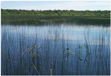
St. Lawrence River
Photo: Martin Jean © Environment and Climate Change Canada
The Canada-Quebec Agreement on the St. Lawrence, also known as the St. Lawrence Action Plan 2011-2026, covers a span of 15 years, with 5-year planning cycles.
For the year 2015-2016, which was the end of the five-year planning cycle for 2011-2016, 43 projects of the joint action program were completed, for which a number of research projects, fieldwork activities, and decision-making tools were developed and completed, including:
- An Integrated Biodiversity Conservation Plan for the Lowlands and Coastal Areas of the Estuary and Gulf of St. Lawrence;
- a study on the impact of climate change on water levels
- a campaign to develop agricultural watercourses in the floodplain of Lac Saint-Pierre to reduce the spread of pollution from agricultural sources;
- identification of the effects of diffuse pollution from agricultural sources on the aquatic ecosystems of the St. Lawrence River;
- ;a study to document the presence of pharmaceuticals in municipal effluents in the Montréal area and to assess their effects on wild aquatic species
- development of a decision-making framework for the assessment of contaminated sediments and their impact on the quality of the water and the general environment of the St. Lawrence River;
- development of a guide for the ecotoxicological risk assessment and for the health of contaminated sediments sites in the St. Lawrence River;
- identification of key environmental issues related to the presence of contaminated sediments in several areas of the St. Lawrence River in order to obtain a more complete and coherent picture of contaminated sediment sites.
Community involvement and awareness
The ZIP Program supports Stratégies Saint-Laurent and its members (the 12 Areas of Prime Concern committees) in their efforts to mobilize and coordinate the various parties involved in issues affecting the St. Lawrence, and to foster their commitment to improving the quality of the environment. In 2015-2016, the activities included collaboration with local authorities to highlight local environmental issues linked to the St. Lawrence River, consultation on emerging issues (hydrocarbon transport on the river, port development, management of invasive species), participation in information activities related to shoreline erosion, sustainable development of coastal environments and preservation of different uses (bathing, access), as well as habitat conservation and Improvement of natural environments. In addition, the ZIP committees have made a significant contribution to the integrated management approach of the St. Lawrence River at the local level, in particular through their commitments to the establishment of 6 Regional Tables on priority regional issues.
Under the St. Lawrence Action Plan 2011-2026, ECCC and Quebec’s ministère du Développement durable, de l’Environnement et de la Lutte contre les changements climatiques are also implementing the Community Interaction Program (CIP), which supports non-governmental organizations that implement projects that benefit the St. Lawrence. In 2015-2016, ECCC funded 21 projects for a total of $552,555 in contributions; these were carried out throughout the program area, from Cornwall to Gaspé, including the Magdalen Islands, and on the north shore, from Carillon to Blanc-Sablon, including the Anticosti and Saguenay regions. These projects involved key players from riverside communities, including municipalities, First Nations, academia, industry and agriculture, local communities, and relevant provincial and federal departments. Specifically, the projects funded in 2015-2016 were intended to give rise to voluntary change in salmon fishing practices in the Innu community of Natashquan; to contribute to the recovery of the American eel through the evaluation of its habitat and the production of a feasibility study for the installation of fish passages in the Saint-Charles River in Quebec City; to manage yellow perch habitats in the river area of the Bécancour sector; and to restore coastal habitats in the Matane region. In addition, 33 new project proposals were submitted to the CIP in 2015-2016 for activities beginning in 2016-2017. Finally, the fifth edition of the Forum Saint-Laurent, on the theme of improving water quality, was held in Quebec City in November 2015. This forum for discussion and dialogue among the parties concerned by issues related to the water in the St. Lawrence River provided an opportunity to identify common directions relating to this theme.
The State of the St. Lawrence River Monitoring Program
A network of governmental and non-governmental partners and collaborators continued to conduct sampling campaigns required to obtain scientific data through the State of the St. Lawrence River Monitoring Program. ECCC collected data on water levels and flow rates; the fluvial transport of contaminants; water and sediment quality; land cover; benthic communities at Lake Saint-Pierre; seabird populations, in particular the Great Blue Heron; and shellfish water quality.
During 2015-2016, ECCC published seven new fact sheets on environmental indicators online. Each fact sheet contributes to our understanding of the state of the St. Lawrence River. They deal with oceanographic processes in the estuary and Gulf of St. Lawrence, the surface areas of freshwater wetlands, contamination of sediments by toxins (butyltins), the Northern gannet and seabirds, and shellfish water quality.
The Working Group on the State of the St. Lawrence River published the Overview of the State of the St. Lawrence River 2014, and started to prepare the next Rendez-vous Saint-Laurent 2016 to be held in Québec city in October 2016. This overview, which is released every five years, aims to inform decision-makers and riverside communities by giving them an analysis of the river’s condition and evolution, while also addressing global environmental issues and future perspectives.
Numerical Environmental Prediction Program
The Numerical Environmental Prediction Program for the St. Lawrence is a program to aid decision making and water management planning for the St. Lawrence and its watershed. It simulates the evolution of physical, biological or chemical processes in the St. Lawrence and its watershed to predict the state of the corresponding terrestrial and aquatic environment. The program aims in particular to improve our understanding of the St. Lawrence ecosystem as a whole and to provide a tool to support decisions about its integrated management. The program is being carried out by a working group whose activities in 2015-2016 made significant progress, notably through four projects that dealt with the coupling of the hydrological models of the St. Lawrence watershed, the integration of hydrodynamic modelling tools into the Montréal archipelago, and hydrological and hydraulic modelling of the Richelieu River watershed. The group also supported various activities under the St. Lawrence Action Plan’s three main issues, which are conservation of biodiversity, sustainability of uses and water quality improvement.
Case Study: Static flood inundation mapping for Lake Champlain and Richelieu River
The International Lake Champlain-Richelieu River Technical Working Group was established by the International Joint Commission (IJC) to carry out two components related to its 2013 Plan of Study (portable document format, 2.71 megabytes) on flooding in the Lake Champlain Richelieu River basin:
- collecting and harmonizing data on the topography, bathymetry, aquatic vegetation, soil texture and other features of the Lake Champlain-Richelieu River watershed; and
- creating static flood-inundation maps showing those areas, where data are available, that would be affected at different water levels on Lake Champlain and the Richelieu River.
From October 1, 2014 to September 30, 2015 a number of federal and state/provincial agencies worked together to enhance flood preparedness and warnings for Lake Champlain and the Richelieu River (LCRR). The one-year case study yielded impressive results that were well received by the IJC and are now being tested by the Quebec government. Results included the development of a new method for flood plain mapping and associated static flood inundation maps for a variety of flooding scenarios (Scenario #7 being the closes to the severe flood the region experienced in 2011) and preparatory work for a future dynamic flood forecasting system.
Another notable result was the introduction of an attempt at quantifying some of the uncertainties associated with delineation of flood maps. The maps show shades of blue to indicate the depths of inundation expected under each scenarios, and yellow bands on each side of the delineated flood zone that represent the uncertainty of +/- 20 cm in determining what areas would flood under the chosen scenario. This is calculated based on the slope of the land - when there slope is low (i.e. fields), the error band is wide, and where the land is steep, the error band, and therefore the uncertainty, is smaller. This simple uncertainty estimation was accomplished by subtracting the surface elevation provided by a 2D hydraulic model from a Digital Elevation Model (DEM) based on LiDAR data.
The International Lake Champlain-Richelieu River Technical Working Group presented their final report and technical reports to the International Joint Commission on November 30, 2015. The International Joint Commission presented their final report (portable document format, 6,81 megabytes), built on the work of the International Lake Champlain-Richelieu River Technical Working Group, to the governments of Canada and the United States in December 2015.
5.3. Atlantic Ecosystem Initiatives
The Atlantic Ecosystems Initiatives program provides funding for projects that improve the health, productivity, and long-term sustainability of ecosystems in Atlantic Canada. The program supports projects that use an ecosystem-based approach that include broad partnerships and collaborative action resulting in positive environmental impacts throughout Atlantic Canada. The program funds Atlantic Canadian organizations, including non-government organizations, coalitions and networks of organizations, research and academic institutions, and Indigenous governments and organizations to deliver projects that address one or more of the three program priority issues of water quality, habitat and biodiversity, and the impacts of climate change.
ECCC contributed funding, technical and scientific expertise, and direct staff support, for water quality projects relevant to the Canada Water Act that will improve the assessment, monitoring, modeling, and mitigation of multiple stressors and their cumulative effects on water quality in Atlantic Canada from headwaters to estuaries.
In 2015-2016, 6 projects (representing 43% of all projects funded by the Atlantic Ecosystems Initiatives program) addressed water issues related to water quality, habitat and biodiversity, and impacts of climate change. ECCC committed over $920,000 for these projects. The following examples demonstrate the type of projects that were funded:
- In Nova Scotia, the Clean Foundation is bringing together experts and stakeholders throughout Atlantic Canada to address stormwater-related impacts of climate change through the adoption of Low Impact Development (LID) systems. The goal is to better manage water quantity and flow, while mitigating the associated impacts to water quality and habitat and biodiversity.
- In Newfoundland and Labrador, C-Core is developing a framework for wetland mapping and monitoring for the province, as well as producing wetland inventory maps of the Avalon Peninsula using remote sensing technologies and implementing the developed framework.
- In New Brunswick, the Association of Canadian Delegates to the Gulf of Maine Council on the Marine Environment is managing a project that supports climate change risk preparedness in Atlantic Canada by providing a web-based tool which will improve access to Intensity/Duration/Frequency (IDF) extreme rainfall data. Access to this data will enhance the technical capacity to predict flooding and other impacts associated with extreme precipitation events and help to better prepare for climate change impacts.
5.4. Gulf of Maine
ECCC is working collaboratively with other federal departments, provincial governments, U.S. governments, and community groups to help advance efforts that enhance conservation and promote responsible development in the Gulf of Maine transboundary ecosystem, which includes watersheds and coastline in New Brunswick and Nova Scotia.
The focus of the Gulf of Maine Initiative is enhancing collaborative efforts to build knowledge of the ecosystem--watershed and coast--to better understand its current condition and identify stressors and threats to help inform decisions.
2015-2016 saw the continuation of seven multi-year projects (87% of the Gulf of Maine Initiative projects) that address water quality issues in the Gulf of Maine ecosystem. Some examples of the projects include:
- Researchers from Dalhousie University are investigating the threat that ocean acidification imposes on ecosystem health and will integrate their results with U.S. initiatives to generate a comprehensive view of the entire Gulf of Maine ecosystem.
- The World Wildlife Fund Canada is conducting a Freshwater Health Assessment and a Freshwater Threats Assessment throughout the entire Canadian portion of the Gulf of Maine ecosystem to quantify the top threats to the Gulf of Maine and identify the key drivers behind them.
Other Gulf of Maine Initiative grants and contribution (G&C) project activities included collecting and making accessible information on eutrophication and contaminants, applying the Ocean Health Index to assess the health of the Gulf of Maine, identifying linkages between environmental stressors and upstream land use activities in the Annapolis watershed (Nova Scotia), and the development of a strategic framework to understand, monitor and manage the cumulative effects from multiple stressors in Saint John Harbour (New Brunswick).
In addition to the G&C projects, the Gulf of Maine Initiative supported a collaborative ECCC and Fisheries and Oceans Canada project that will enhance regional storm surge flood modelling and forecasting to better inform development decisions by coastal communities and resource users. In an effort to build a better collective understanding of the Gulf of Maine ecosystem, the Gulf of Maine Initiative is helping to facilitate on-going dialogue on regional coastal mapping activities and sharing of existing data, as well as opportunities to coordinate resources for new mapping and data acquisition activities.
Lake Winnipeg Basin Initiative
The Lake Winnipeg Basin Initiative (LWBI) is the Government of Canada’s response to address the water quality issues in Lake Winnipeg. The LWBI aims to engage citizens, scientists, and domestic and international partners in actions to restore the ecological health of Lake Winnipeg, reduce nutrient pollution and improve water quality.
Phase II of the LWBI ($18 million, 2012-2017) continues. This phase increases focus on stakeholder stewardship actions that measurably reduce nutrient loading and improve Lake Winnipeg’s water quality.
Some key highlights from 2015-2016 include:
- The Lake Winnipeg Basin Stewardship Fund (LWBSF) provided financial support for 31 stewardship projects valued at $1.2 million;
- The Lake Winnipeg Basin Office (LWBO) hosted the 2nd Annual LWBSF Symposium on March 7, 2016 in Winnipeg. The Symposium recognized and highlighted the important work, collaboration and contributions made by LWBSF recipients to reduce nutrients in Lake Winnipeg and the basin;
- The Nutrients in Lake Winnipeg Indicators report was published in February 2016. This report forms part of the Canadian Environmental Sustainability Indicators (CESI), which provides data and information to track Canada's performance on key environmental sustainability issues;
- The Canada-MB MOU Respecting Lake Winnipeg and the Lake Winnipeg Basin was extended to September 2020. The MOU facilitates a cooperative and coordinated approach in efforts to understand and protect the water quality and ecological health of Lake Winnipeg and its basin.
The Government of Canada continued to provide support for stakeholder-driven projects through the LWBSF. In 2015-2016, ECCC approved over $317,000 for 13 new LWBSF projects aimed at reducing nutrient loading in the Lake Winnipeg Basin. Since its inception in 2008, the LWBSF has provided over $6.7 million in federal funding for 88 stakeholder-driven projects ranging from wetland restoration to innovative waste-water treatment, and beneficial agricultural practices to cutting-edge scientific research. For every dollar provided by the fund, approximately $2.63 in additional partner funds and in-kind contributions were generated. In total, stakeholder-driven projects valued at over $23 million have benefitted the Lake Winnipeg Basin.
The LWBI continued to provide annual funding support to the Lake Winnipeg Research Consortium, which operates the MV Namao and MV Fylgja, two research and monitoring vessels. In addition, annual funding support was provided to the University of Manitoba for the Lake Winnipeg Basin Information Network, a web-based information portal for exchange of scientific information generated in the Lake Winnipeg Basin.
The LWBI emphasizes collaborative work with other governments (provincial, state, federal) and organizations within the Lake Winnipeg transboundary watershed. Domestic and international water management boards play a key role in managing nutrients in the Lake Winnipeg Basin. ECCC participates in a number of water science and water management boards to facilitate coordination of efforts across the watershed and to help address nutrient loading originating from outside of Manitoba’s jurisdiction.
Research, modelling and monitoring activities in 2015-2016 included the ongoing implementation of 13 scientific research projects in Lake Winnipeg and its watershed focusing on the identification of the sources and impacts of nutrient loadings to Lake Winnipeg. Work is well under way in a number of areas, including water quality monitoring of key transboundary sites and related main rivers.
Projects in 2015-2016 focused on:
- addressing knowledge gaps related to the impacts of human activity (particularly land use) on nutrients in Lake Winnipeg tributaries.
- addressing critical knowledge gaps in lake nutrient dynamics relative to changes in nutrient loads to Lake Winnipeg, by evaluating the spatial and temporal flux of nutrients from the watershed to Lake Winnipeg and evaluating the fate of these nutrients once in the lake, particularly in relation to internal nutrient recycling from sediments and the factors driving harmful algal blooms; and
- developing predictive models in support of nutrient management in the Lake Winnipeg Basin.
5.5. Pacific and Yukon Region
During 2015-2016, ECCC committed close to $200,000 to support projects across British Columbia and Yukon, including in the Okanagan Basin. These projects advanced the development and implementation of water balance models and ecosystem health indicators to support informed decision making, as well as to protect habitat and biodiversity.
In the Okanagan, ECCC supported the development of a protocol to determine water levels that are needed by fish in major tributary streams. This work will inform the actions and decisions of governments, and lead to higher fish survival and less conflict between water users. ECCC also supported the implementation of the Biodiversity Conservation Strategy for the Okanagan Region (2014) by providing funding to identify habitat connectivity corridors, mechanisms for conservation across all land uses and tenures, and parkland acquisition priorities in North Okanagan. This work will inform actions and decisions of governments, business and individuals that share in the responsibility of conserving biodiversity in the region.
In the Yukon, ECCC supported a collaborative project with the Arctic Borderlands Ecological Knowledge Society to increase the capacity of the Society and its partners to use and integrate both science and traditional knowledge within their decision-making framework. This will form the basis for integrating new traditional and local knowledge indicators within an ecosystem management framework, as well as helping to increase the number of communities that contribute ecological knowledge to the community-based monitoring network coordinated by the Society.
ECCC also supported the development of capacity-building tools, resources, and research to help BC watershed governance groups effectively engage in watershed decision-making.