
Nanoose Harbour Practices and Procedures
May 2025
Alternate Formats
- 1. Preamble
- 2. Definitions
- 3. Authority of Harbour Official
- 4. Entry, Movement, Departure Clearances
- 5. Speed Limits
- 6. Controlled Access Zones
- 7. Contractor Requirements – Marine Projects
- 8. WG Range – Canadian Forces Maritime Experimental and Test Ranges (CFMETR)
- 9. Pleasure Craft
- 10. Derelict, Abandoned, Illegally Anchored or Moored Vessels
- 11. Sewage Discharge
- 12. Discharge of a Pollutant to Marine Environment
- 13. Tug or Pilot Services
- 14. Towing of Ships
- 15. Securing, Crewing, and Propulsion Requirements for Ships
- 16. Turning of Propellers Alongside
- 17. Scaling and Painting of Ships
- 18. Equipment Protruding Beyond Ship’s Side
- 19. Rafting of Ships
- 20. Ship-to-Ship Transfers
- 21. Activities that Require Pre-Authorized Approval
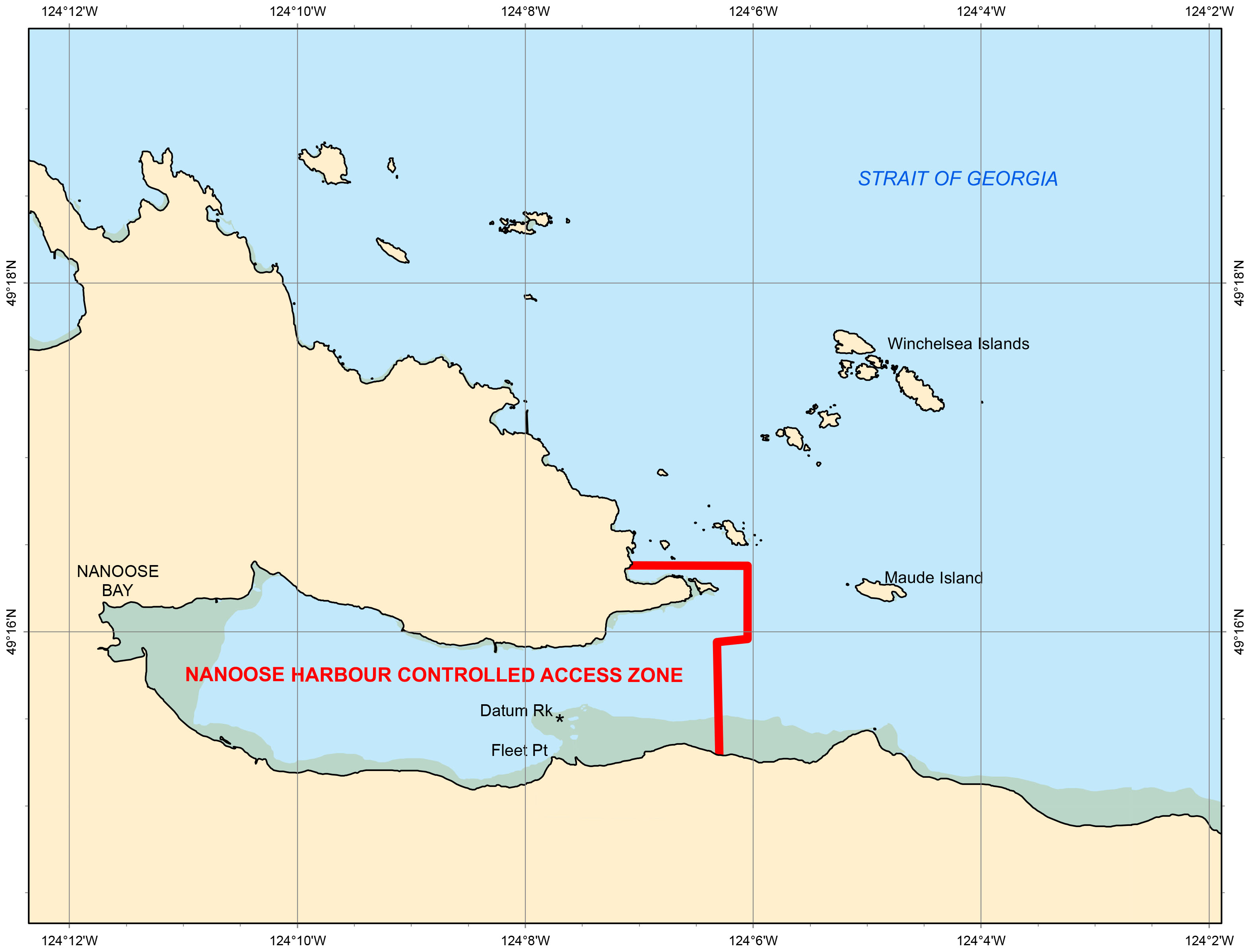
1-1 Nanoose Harbour is a public harbour, within the meaning of Section 108 of the British North America Act, and subject to Federal jurisdiction. In these practices and procedures, it will be referred to simply as ‘the harbour.’ The Nanoose Harbour limits are defined as all the navigable waters, including any foreshore, within Nanoose Bay to the west of a line running from the easternmost tip of Wallis Point (Latitude 49°16.250′ N, Longitude 124°06.305′ W) to a point due south on the shore at (Latitude 49°15.295′ N, Longitude 124°06.305′ W).
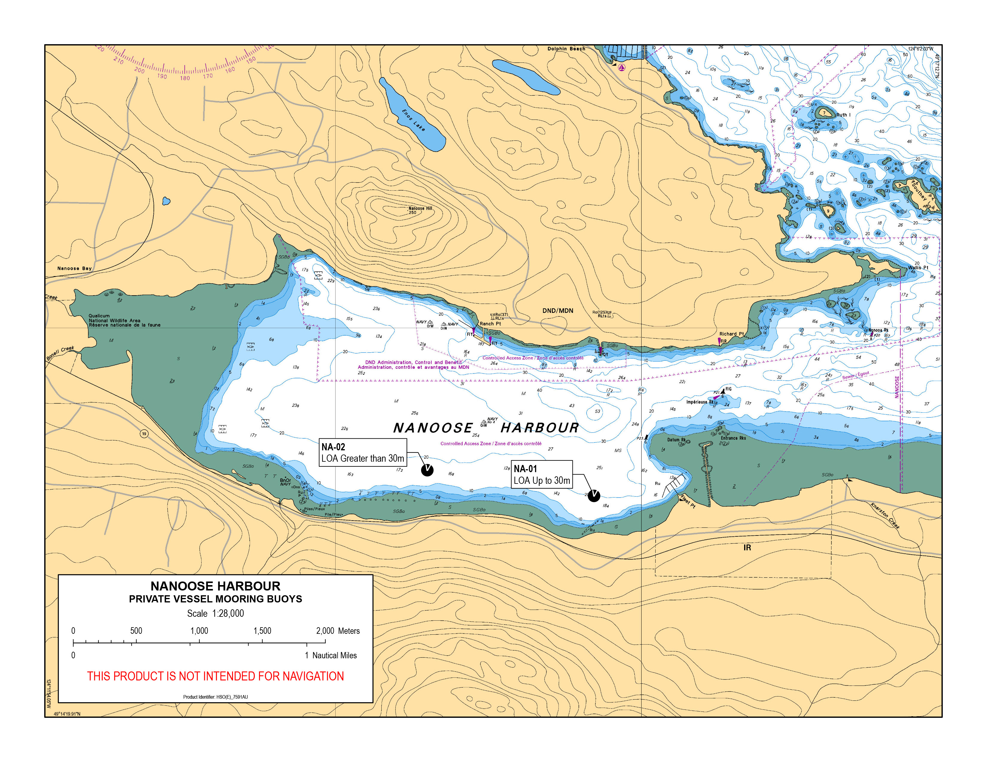
1-2 For official information on marine aids to navigation and water depths in Nanoose Harbour, refer to Chart 3459, published by the Canadian Hydrographic Service.
1-3 The Minister of National Defence has designated the entire area of Nanoose Harbour and its approaches to be a Controlled Access Zone. Any vessel operating in proximity of this zone may be approached and hailed by the Department of National Defence.
1-4 The harbour is open to the public subject to and within the limitations set out in an Order in Council regarding Controlled Access Zones (Controlled Access Zone Order (Halifax, Esquimalt and Nanoose Harbours) (SI/2003-2) https://laws-lois.justice.gc.ca/eng/regulations/SI-2003-2/FullText.html). This provides for security zones surrounding Department of National Defence property and ships berthed or moving in the harbour. Refer to Section 6 Controlled Access Zones for amplifying information.
1-5 These practices and procedures are made pursuant to the Canada Marine Act Section 56 and amplify the Natural and Man-made Harbour Navigation and Use Regulations.
1-6 These practices and procedures are intended to promote the safe and effective use, navigation, and environmental stewardship of the harbour. They are to be followed by all harbour users, including ships entering, manoeuvring, berthing, departing, anchoring, or working in the waters of Nanoose Harbour, designated by regulation pursuant to the Canada Marine Act Section 104 Subsection (2).
1-7 For the purpose of these practices and procedures, where a subject is referred to in the singular, it will also represent the plural of the same subject.
1-8 These practices and procedures may be amended from time to time, as circumstances dictate. An emergency amendment(s) may be made to this document without notice and be effective immediately. Unless otherwise indicated, implementation of a practice or procedure will be effective 30 days after publication of the new or amended practice or procedure.
1-9 Unless authorized by a harbour official, no person shall, by act or omission, do anything or permit anything to be done in the harbour that has, or is likely to have, any of the following results:
- adversely affect harbour operations;
- interfere with navigation;
- jeopardize the safety or health of persons or property;
- obstruct or threaten any part of the harbour;
- interfere with an authorized activity;
- divert the flow of a river or stream, cause or affect currents, cause silting or the accumulation of material or otherwise reduce the depth of the waters;
- cause a nuisance;
- cause damage to ships; and
- adversely affect sediment, soil, air or water quality.
1-10 Under the Canada Marine Act Section 59 Subsection (1)(a), it is an offence, subject to financial penalty, if a person or ship does not adhere to these practices and procedures.
2-1 “BARGE” means a vessel designed with no means of self-propulsion.
2-2 “CANADIAN MARITIME DOCUMENT” means a licence, permit, certificate or other document that is issued by the Minister of Transport under Part 1 (General),
3 (Personnel), 4 (Safety), 9 (Pollution Prevention - Department of Transport) or 11 (Enforcement - Department of Transport) to verify that the person to whom or vessel to which it is issued has met requirements under that Part. (from the Canada Shipping Act, 2001)
2-3 “CLEARANCE” means granting authorization to carry out a manoeuvre or task. This can be given verbally, in writing, or transmitted by electronic means.
2-4 “CONTROLLED ACCESS ZONE” means a zone designated by the Minister of National Defence, which includes all corresponding airspace above, and water and land below the zone. In general, Controlled Access Zones are areas intended to create buffer zones, to ensure the safety and security of Canadian Armed Forces and Department of National Defence naval vessels, materiel, and property, warships under the control of a visiting force, acting under the Visiting Forces Act, and personnel.
2-5 “DANGEROUS GOODS” has the meaning assigned in Section 2 of the Transportation of Dangerous Goods Act, 1992.
2-6 “discharge” means a discharge of a pollutant from a vessel, or a discharge of oil from an oil handling facility engaged in loading to or unloading from a vessel, that directly or indirectly results in the pollutant entering the water, and includes spilling, leaking, pumping, pouring, emitting, emptying, throwing and dumping.
2-7 “HARBOUR OFFICIAL” means officials appointed pursuant to the Canada Marine Act Sections 106 and 108 and include the King’s Harbour Master, Deputy King’s Harbour Master, Harbour Traffic Control Officer, or other designated harbour officials.
2-8 “HOT WORK” means any work that uses flame, or that can produce a source of ignition, such as heating, cutting or welding.
2-9 “KNOTS” means nautical miles per hour.
2-10 “LIVE-ABOARD VESSEL” means any vessel used primarily as a residence, or any vessel represented as a place of business, a professional or other commercial enterprise, or a legal residence, except those vessels in contract with Canada.
2-11 “MASTER” means master, owner, agent, operator, or person in charge of a ship.
2-12 “PILOT” refers to Department of National Defence Pilot, B.C. Coast Pilot, or Public Services and Procurement Canada Docking Master.
2-13 “PLEASURE CRAFT” means a vessel that is used for pleasure and does not carry passengers, and includes a vessel of a prescribed class.
2-14 “pollutant” means:
- a substance that, if added to any waters, would degrade or alter or form part of a process of degradation or alteration of the quality of the waters to an extent that is detrimental to their use by humans or by an animal or a plant that is useful to humans; and
- any water that contains a substance in such a quantity or concentration, or that has been so treated, processed or changed, by heat or other means, from a natural state, that it would, if added to any waters, degrade or alter or form part of a process of degradation or alteration of the quality of the waters to an extent that is detrimental to their use by humans or by an animal or a plant that is useful to humans.
It includes oil and any substance or class of substances that is prescribed for the purpose of this Part to be a pollutant. (from the Canada Shipping Act, 2001)
2-15 “PRINCIPAL TOWING SHIP” means the towing ship, the Master of which is responsible for the manoeuvring and conduct of all ships being towed.
2-16 “SCALING” includes scraping, sanding, chipping, grinding, sandblasting, hydroblasting or any other means of dislodging paint, rust or other unwanted material from the hull, superstructure, machinery or equipment contained on-board, or otherwise attached to a ship.
2-17 “SEAPLANE” includes any aircraft designed to manoeuvre on the water.
2-18 “SHIP” means every description of vessel, boat or craft designed, used or capable of being used, solely or partly for marine navigation, whether self-propelled or not and without regard to the method of propulsion, and includes a seaplane and a raft or boom of logs or lumber.
2-19 “SMALL VESSEL” means all ships less than 20 metres in length.
2-20 “TOWED SHIP” means any ship that is not self-propelled, and in order to manoeuvre, it must be pushed or pulled by another ship.
2-21 “TRAFFIC CONTROL OFFICER” refers to the Officer of the Watch, on duty, in the King’s Harbour Master Harbour Control Office, Winchelsea Island Control Office or in the Regional Joint Operations Centre, Maritime Forces Pacific.
2-22 “VESSEL” see Ship definition.
3-1 A harbour official may issue instructions directly to a ship. These instructions may be given verbally, electronically, or in writing. Notwithstanding the means by which they are conveyed, they carry the same weight.
3-2 A harbour official is the sole authority concerning all matters related to marine traffic control, within the limits of Nanoose Harbour, including assigning berths or anchorages, or authorizing a ship to stay. In the absence of authorization from a harbour official, a ship taking up a position in the Nanoose Harbour limits, because of the information obtained from other sources, may have to change its position upon receipt of instruction from a harbour official.
4-1 All ships, prior to entering, moving within, or departing Nanoose Harbour shall contact the Winchelsea Island Control Office, on VHF CH10 or 16, VHF WX CH1 or CH3, or by telephone at 250-468-5080 or 1-888-221-1011 (toll free). All ships will monitor VHF 21B or WX3. Ships are to give as much advance notice as is practicable. The following information shall be conveyed in the clearance request:
- ship name;
- port of registry, if applicable;
- time of arrival;
- estimated time of departure;
- length, breadth, and draft of the ship;
- the presence of dangerous goods on-board; and
- harbour destination.
4-2 No ship that has explosives (Class 1 as indicated in the Transportation of Dangerous Goods Act) on-board shall enter, move, or depart within the limits of Nanoose Harbour unless authorized by a harbour official.
5-1 All vessels shall operate at a safe speed (5 knots or less), while in Nanoose Harbour. They shall further reduce speed to minimum wake when passing ships that are anchored, berthed alongside, or engaged in marine operations.
5-2 In special circumstances, a harbour official may grant permission for ships to exceed the speed limit.
6-1 Vessels are always to remain 200 metres away from stationary DND vessels, jetties or Navy buoys, and vessels underway. Unauthorized intrusions could lead to Federal prosecution. Further information concerning Controlled Access Zones is available in the Canadian Coast Guard Notices to Mariners, National Defence – Military Notices.
6-2 Any vessel may be hailed by the King’s Harbour Master, and/or hailed and approached by any Military Police or Military Force Protection vessel. Due to force protection/security requirements, access to Nanoose Harbour may be restricted and/or blocked.
6-3 For the purpose of enforcing the Canada Marine Act and the Natural and Man-made Harbour Navigation and Use Regulations, all designated controlled access zones printed on Chart 3459 are the same.
7-1 The contractor warrants that all vessels used in Nanoose Harbour are mechanically sound, completely seaworthy, equipped with readily accessible lifesaving equipment, will be adequately manned, and in full compliance with the Canada Shipping Act, 2001 (S.C. (Statutes of Canada) 2001, c. 26). Contractors must provide on demand and no later than 24 hours after demand, true copies of all Canadian Maritime Documents to a harbour official for vessels and crew related to requirements listed in the Canada Shipping Act, 2001 and associated regulations.
7-2 Contractors must provide, upon demand by a harbour official, a recent condition survey (within the last 4 years) carried out by a qualified and certified marine surveyor, for barges and other marine equipment operated by the contractor in the harbour, clearly indicating that their condition meets all seaworthy and safety standards, and their suitability for the proposed use.
7-3 Contractors must provide documentation, upon demand by a harbour official, showing that their marine assets in Nanoose Harbour are insured.
7-4 Commercial vessels under 15 Gross Tonnage must provide proof of current enrollment in the Transport Canada Small Vessel Compliance Program.
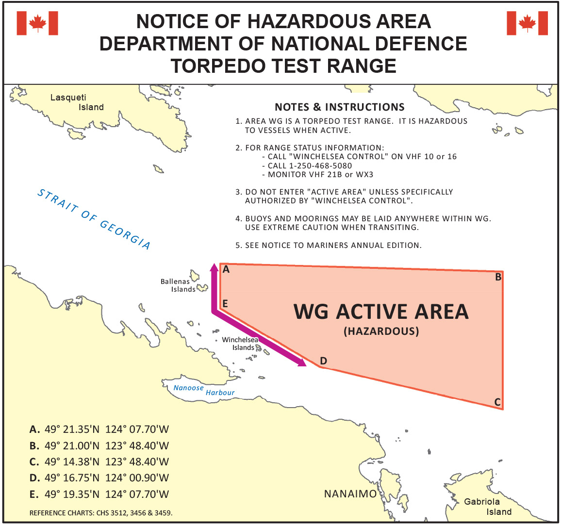
8-1 Area WG constitutes a Defence Establishment as defined in the National Defence Act to which the Defence Controlled Access Area Regulations apply. Vessels which do not comply with direction from the Range Officer, Harbour Official or Range Patrol Vessels may have a monetary penalty levied against them.
The WG Federally Expropriated Area is clearly depicted on CHS Chart 3512, 3456 & 3459 by means of a single solid line.
The WG Active Exercise Area is clearly depicted on CHS charts 3512, 3456 and 3459 by means of pecked lines, and can be found by the following coordinates:
- 49° 21.35'N 124° 07.70'W
- 49° 21.00'N 123° 48.40'W
- 49° 14.38'N 123° 48.40'W
- 49° 16.75'N 124° 00.90'W
- 49° 19.35'N 124° 07.70'W
*For clarification, the Active Exercise Area for WG is within the Federally Expropriated area.
8-2 All vessels shall keep free and clear of WG Range while active.
8-3 A transit area 1,000 yards north of Winchelsea Island and 1,000 yards east of South Ballenas Island is recommended to enable mariners to transit safely around the active area. It also facilitates unimpeded access to marina facilities in Schooner Cove and Nanoose Bay. A pictograph of this corridor may be found on the Nanoose Harbour Website: https://www.canada.ca/en/navy/corporate/nanoose-harbour.html
8-4 Vessels may obtain current WG Range status by contacting Winchelsea Control by phone at 250-468-5080 or 1-888-221-1011 (next day's activity only), by radio on VHF CH10, VHF WX CH1, VHF 21B or Weather 3 & CH3 or by checking the Canadian Coast Guard Navigational Warnings (NAVWARN’s) website and entering ‘WG’ into the ‘Search Terms’ input field.
8-5 Vessels may obtain WG Range status by contacting CFMETR Range Officer at 250-468-5002 (long range planning).
8-6 There is no anchoring, fishing, crabbing or marine trapping permitted while the range is active within the WG Active Area.
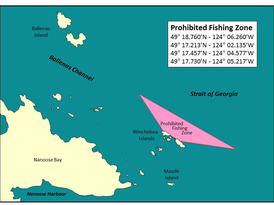
8-7 There is no anchoring, fishing, crabbing or marine trapping permitted at any time within the No Anchoring/Fishing zone NNE of Winchelsea Island, by authority of the Minister of National Defence. (See Chart 3456, 3459 or 3512.) While the No Fishing/Anchoring zone NNE of Winchelsea Island is outside the WG range ‘exercise area’ border limit, it is still within the Federal Expropriated area that is administered and assigned to the CF/DND. The CF/DND has the authority to manage and close the range and water within this border on an as needed basis. The purpose of this closure is to protect mariners from high-power submarine cables running from Winchelsea Island.
8-8 No person shall cause or participate in any disturbance while in, on or about a controlled access area or defence establishment.
8-9 A Range Officer or Harbour Official may issue instructions directly to a ship. These instructions may be given verbally, electronically, or in writing. Notwithstanding the means by which they are conveyed, they carry the same weight. The instructions given to a vessel must be followed promptly and in a safe manner. Failure to follow these instructions may result in a monetary penalty being imposed.
8-10 A Range Officer is the sole authority concerning all matters related to marine traffic control, within the limits of the WG Range Active Area. Any vessel within the area will be required to clear or stop on demand from Winchelsea Control or any of the range vessels or range helicopter.
8-11 Range vessels exhibit a flashing red light in addition to the prescribed lights and shapes. These vessels may operate outside of scheduled hours and should not be approached within 3,000 yards because they may be in a three-point moor with mooring lines extending to buoys 1,500 yards away. Additionally, lighted and unlighted mooring buoys are randomly located within the area. Mariners are advised to use caution when transiting this area during non-active range periods to avoid mooring buoys and lines.
9-1 All pleasure craft entering the harbour must be licenced or registered in accordance with the Small Vessel Regulations. All pleasure craft are required to register their arrival, intended duration of stay, and departure from the harbour, by contacting the Winchelsea Island Control Office, on VHF CH10 or 16, VHF WX CH1 or CH3, or by telephone at 250-468-5080 or 1-888-221-1011 (toll free). Upon arrival, pleasure craft reporting requirement information must be provided to a harbour official. The required procedure to request pleasure craft anchorage is at https://www.canada.ca/en/navy/corporate/nanoose-harbour.html. The completion and return of the form is to be administered within 1 hour of arrival in the harbour.
9-2 Pleasure craft, whether power driven or sail, and small vessels, which are operating under the guidance of the Small Vessel Regulations, shall not impede the passage and manoeuvring of larger commercial ships or naval ships, within the limits of Nanoose Harbour, and shall always maintain a lookout while underway.
9-3 Pleasure craft are prohibited within 200 meters (600 feet) of all CF or DND assets. This includes jetties, floats, docks, pilings or buoys.
9-4 Do not anchor your vessel anywhere in Nanoose Harbour, unless you have received authorization from a harbour official. Pleasure craft may only anchor in the southern portion of Nanoose harbour west of Datum Rock and south of the Navy buoy. Every pleasure craft anchored in Nanoose Harbour shall be moored with two anchors and in the manner directed by a harbour official.
9-5 Vessels may tie off on one of two mooring buoys (NA-01 for vessels up to 30m and NA-02 for vessels greater than 30m) on a first come first served basis. These buoys are located at the southern portion of Nanoose harbour west of Datum Rock and south of the Navy buoy at coordinates NA-01: N49°15’16.10 W124°08’20.80 and NA-02: N49°15’23.56 W124°09’24.92.
9-6 Nanoose Harbour is open to the public for temporary recreational use only. Authorization for pleasure craft anchorage will not exceed a maximum of 21 nights during a 40-day period. Long term anchoring of pleasure craft is prohibited in Nanoose Harbour. Boaters may extend their stay by moving to a marina after their allowable anchoring time has expired.
9-7 The following activities are prohibited in Nanoose Harbour:
- discharging of black water (sewage);
- rafting of pleasure craft at anchor; and
- live-aboard vessels, whether temporary or permanent, including the use of houseboats, rafts, scows, boats or other floating structures when such structures are used for sleeping or dwelling purposes.
10-1 Where the owner or person in charge of a vessel, in the harbour, is not available or refuses or neglects to obey any order to move the vessel, the Harbour Authority may, at the risk and expense of the owner of the vessel:
- take possession of and move the vessel;
- use any means and force reasonably necessary to move the vessel;
- berth, anchor, moor the vessel at any place satisfactory to the Harbour Authority; or
- remove and dispose of the vessel.
11-1 No ship or person on-board a ship, shall discharge sewage into the tidal waters of Nanoose Harbour. Sewage means human excrement and waste from toilets and other receptacles intended to receive or retain human body waste or other waste; however, does not include galley or washing facility waste. In addition, any vessel in Nanoose Harbour that has a toilet must be fitted with a functioning Transport Canada approved marine sanitation device, holding tank, or temporary storage.
12-1 Any person, facility, vessel or property, hereinafter referred to as the Polluter that accidentally or intentionally discharges a pollutant into Nanoose Harbour, shall be responsible for the reporting, clean-up, and cost of the incident.
12-2 The Polluter is required to immediately notify the Harbour Authority at 250-363-2160 or 250-468-5080, Emergency Management British Columbia at 1-800-663-3456 (all available 24hrs a day 7 days a week), and initiate clean-up.
12-3 Once notified, the Harbour Authority will assess the situation, monitor the response, and assist, as necessary.
12-4 In the event that the Polluter is either unwilling or unable to respond, the Harbour Authority may assume control of the response. The Harbour Authority may request assistance from the applicable Federal Authority (e.g. Environment Canada, Canadian Coast Guard). The response undertaken by the Harbour Authority, with or without the assistance of a Federal Authority, will be at the cost and expense of the Polluter and that such cost and expense is a debt due to the Crown.
13-1 When circumstances and conditions threaten environmental protection, safety of port infrastructure or navigational safety, a harbour official may require ships to obtain the services of a Pilot and tug(s).
13-2 Vessels requiring anchorage are required to request anchorage as outlined in section 8 above and comply with the following:
13-3 If emergency repairs are required, permission may be granted, provided a Stand-by tug or towing ships of adequate power are kept in attendance. (see section 13-5 below)
13-4 Vessels at anchor must not immobilize or disable their main engine or propulsion gear at anchor without permission from the Harbour Authority.
13-5 When a vessel is unserviceable or the primary means of propulsion has been disabled or damaged, a vessel shall, while at anchor at Nanoose Harbour:
- Employ the services of a stand-by tug throughout the duration of anchorage, the fees of which shall be the responsibility of the Master of the vessel.
- The stand-by towing ship shall ensure compliance with directives from Section 7 above.
- The stand-by towing ship should be of sufficient size and with adequate bollard pull to assist the vessel in adverse weather conditions.
- The stand-by towing ship is always responsible for the safety and manoeuvring of its tow.
- Make alternate arrangements to have the vessel returned to seaworthy service with proper approvals from the Harbour Authority, and
- Arrange for transport or tow from Nanoose Harbour at the earliest convenience if the vessel is not able to be repaired.
14-1 The principal towing ship is always responsible for the safety and manoeuvring of its tow.
14-2 When entering, moving within, or departing Nanoose Harbour, a ship shall use a towline length that permits immediate and positive control of the towed ship.
14-3 Ships are responsible for their tow and must ensure that sufficient assets are employed to account for all contingencies that may arise. Due to the risk of damage to other ships or port infrastructure, a trailing tug shall be secured when this is the safest course of action for the prevailing circumstances. If deemed necessary by the Harbour Authority an assist tug must accompany a tow in the following circumstances:
- when arriving, departing, or working within 120 metres of Department of National Defence infrastructure.
14-4 Any deviation from these procedures must be approved, in advance, by the Harbour Authority.
15-1 All ships within the limits of Nanoose Harbour shall have sufficient crew on-board to safely manoeuvre the ship alongside, or to depart a harbour facility, when instructed to do so by a harbour official. Crew, in sufficient numbers shall always be present, to monitor the ship for safety and security purposes; to ensure that mooring lines and gangways are properly tended, and emergencies are responded to.
15-2 Propulsion power shall be available, at reasonable notice, to move the ship when instructed to do so by a harbour official. Before any repairs, maintenance, or other works are undertaken, that may hinder the ship’s ability to move in a harbour facility or anchorage, clearance shall be obtained from a harbour official.
15-3 Anytime emergency repairs are commenced on a ship, at an Nanoose Harbour facility, the Master of the ship will report to a harbour official the nature of the repairs and outline the affect it has on the ship’s ability to move. The Master shall provide an estimate of the time required to complete the repairs to a condition where the ship is capable of being safely moved.
15-4 Clearance will only be given to leave a ship unmanned, while within the limits of Nanoose Harbour, if a harbour official is satisfied that the Master of the ship has made adequate securing arrangements; that mooring lines are tended, and that arrangements are in place to move the ship if instructed to do so. Since it is understood that the time required for preparing to move an unmanned ship may be longer than that required for a fully crewed ship, the length of the notification period will be agreed upon before this clearance is granted.
16-1 A ship, when secured at a harbour facility in Nanoose Harbour, shall not commence basin trials by turning shafts or engaging bow thrusters, without first obtaining permission from a harbour official, and taking the necessary precautions not to endanger the integrity of the harbour facility, its physical assets, other ships, or the environment.
16-2 Clearance may be conditional on extra precautions being followed, such as the use of additional mooring lines, tug assistance, and the equipment or machinery being run at minimum speed.
17-1 A ship at anchor or at a berth, within the limits of Nanoose Harbour, shall obtain clearance from a harbour official to perform scaling and painting of a ship’s hull, machinery, or superstructure. Prior to clearance being granted, the person requesting the clearance shall make an assurance that adequate measures will be taken to protect the environment from the waste material created by the operation.
17-2 Scaling and painting shall not interfere with the operation of another user within the limits of Nanoose Harbour. If a scaling operation involves hot work, then it shall not take place without a Hot Work Permit.
18-1 Unless authorized, no rigging, cargo gear or other equipment on-board any ship berthed in Nanoose Harbour shall overhang or project overboard, in a manner that may endanger life or property, or create a hazard to navigation. If any ship requires equipment to extend beyond the sides of the ship, they shall obtain clearance from a harbour official.
18-2 If any cargo gear or equipment is already swung out and another ship is manoeuvring in the vicinity, a harbour official may require the gear to be swung inboard until the danger has passed.
19-1 A ship may make fast to, or secure alongside another ship in Nanoose Harbour, at a harbour facility, only with the clearance of a harbour official.
19-2 At Federal Government harbour facilities, every ship, when ordered by a harbour official, shall permit another ship to make fast to, or secure alongside it. Sufficient mooring lines, from the outboard ship, shall be passed ashore to ensure that excessive stresses are not placed on the inner ship’s lines, and the outboard ship shall ensure that adequate fendering is provided.
19-3 To avoid overloading jetty bollards, ships shall assess the strain being placed on individual bollards before attaching multiple berthing lines.
20-1 No ship-to-ship transfer of goods shall take place until a harbour official has given clearance. Ship-to-ship transfers will be approved by a harbour official, only if the official has been apprised of the intention and is of the opinion that all necessary steps shall be taken to preserve the integrity of the environment, and that there will be no adverse effects on other users of Nanoose Harbour.
21-1 Pursuant to the Natural and Man-made Harbour Navigation and Use Regulations of the Canada Marine Act, the approval of a harbour official is required prior to the commencement of all activities, including but not limited to the following:
- conducting a diving operation:
- prior to commencement and upon completion of diving operations; and
- all appropriate safety measures shall be taken, including but not limited to displaying flag Alpha, informing nearby vessels, and maintaining a constant listening watch on VHF CH10;
- conducting a salvage operation:
- notice to harbour users to avoid area of salvage operation;
- measures taken to reduce or mitigate further risk or damage; and
- emergency response resources notified;
- transporting, loading, unloading, or transhipping explosives or other dangerous goods, industrial waste or pollutants:
- conducted at a specified facility or between adjacent ships, using appropriate cargo transfer equipment;
- measures taken to reduce or mitigate risk;
- displaying an all-around red light or flag Bravo; and
- emergency response resources notified;
- carrying out a bunkering, fuelling or other oil transfer operation, a chemical transfer operation or a liquefied gas transfer operation:
- conducted at a specified fuelling facility, between adjacent ships, from a tanker truck ashore, or from a bunkering barge alongside, using appropriate cargo transfer equipment;
- measures taken to reduce or mitigate risk;
- displaying an all-around red light or flag Bravo; and
- emergency response resources notified;
- conducting a dredging operation:
- results of the dredging operation will improve the use of the harbour;
- minimize impact on marine traffic and harbour use; and
- an environmental assessment must be completed and approved;
- excavating or removing any material or substance:
- results of the excavation/removal operation will improve the use of the harbour;
- minimize impact on harbour use;
- an environmental assessment must be completed and approved; and
- coordination with upland property activities/landowners;
- building, placing, rebuilding, repairing, altering, moving or removing any structure or work:
- results of these works will improve the use of the harbour;
- minimize impact on marine traffic and harbour use;
- an environmental assessment must be completed and approved; and
- coordination with upland property activities/landowners;
- placing or operating a light or day marker:
- suitable device to be used;
- minimize impact on marine traffic and harbour use; and
- light characteristics are to be in accordance with The Canadian Aids to Navigation System;
- casting adrift a ship, log or other object:
- minimize impact on marine traffic and harbour use; and
- measures taken to mark obstruction and mitigate impacts;
- conducting a race, regatta, trial, demonstration, organized event or similar activity:
- minimize impact on marine traffic and harbour use;
- causing a fire or explosion, conducting blasting or setting off fireworks, including setting off a flare or other signalling device;
- placing a placard, bill, sign or device;
- swimming:
- permitted without permission in areas normally associated with recreational swimming;
- launching a ship by crane;
- conducting the take-off or landing of a seaplane;
- laying up a ship;
- placing, altering, removing or relocating an aid to navigation, buoy, mooring, float, picket, mark or sign;
- mooring or anchoring a floating structure:
- ensure berthing or moorage in a specified area that does not interfere with harbour use and traffic;
- on-board measures taken to reduce or mitigate risk, including protecting the environment; and
- minimize the possibility of nuisance and nuisance complaints;
- fishing, crabbing or marine trapping:
- it shall only be conducted in areas that minimize the impact on marine traffic, harbour use, and it shall be conducted in accordance with the Department of Fisheries and Oceans Canada licencing requirements; and
- consult DFO for local fishing closures and updates;
- conducting aquacultural research or operations.
- flying, releasing, piloting, launching or operating a drone or other air viable airborne craft, with or without a camera, remote controlled or otherwise.
- minimize impact on marine traffic and harbour use; and
- measures taken to mark obstruction and mitigate impacts;
- sailing, launching or placing a water-based device with or without a camera, manned or unmanned, remote controlled or otherwise.
- minimize impact on marine traffic and harbour use; and
- measures taken to mark obstruction and mitigate impacts.