
French River Dam complex
About the French River dams
Find key information about the French River dams, including how they operate, their location and history, the watershed and partnerships.
On this page
- Overview
- The French River Basin
- How water levels are managed
- Seasonal operation
- The dams
- History
- Indigenous context and partnerships
- Related links
Overview
The dams play an important role in managing Lake Nipissing water levels and regulating the flow of water into the French River.
What the dams do
The dams help to:
- maintain water levels suitable for navigation
- reduce the impact of flooding and droughts
- preserve the fishery
Location
The dams are located in northeast Ontario at the southwestern end of Lake Nipissing, where the French River begins. The river flows westward ending at Georgian Bay.
Near Lake Nipissing, the river splits into two channels:
- South channel: Big Chaudière and Portage dams
- North channel: Little Chaudière dam
Further downstream are Wolseley Bay and Dry Pine Bay.
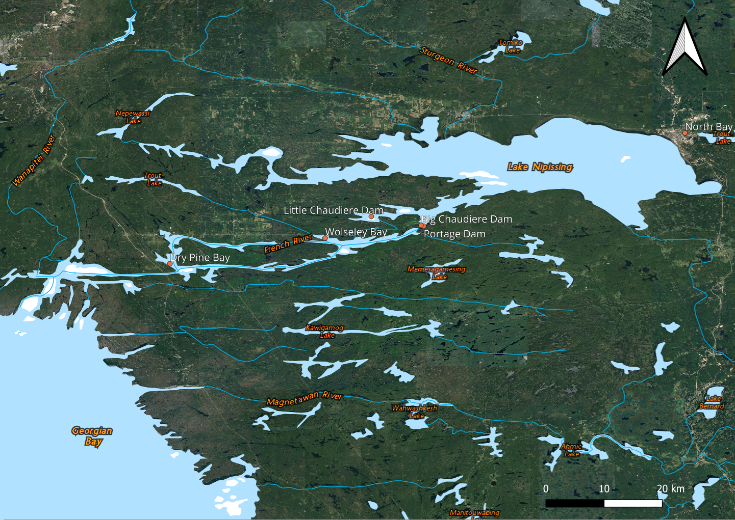
Long description for the map of the French River dams
A map showing the 3 French River dams is shown. The French river rises from Lake Nipissing and flows into the Georgian Bay. The section near Lake Nipissing contains a split where the river forms a ‘Y’ shape. The southern split is where the Big Chaudière Dam and the Portage Dam are located, while the northern split contains the Little Chaudière Dam. Further towards the Georgian Bay, there are also 2 bays, the closest is the Wolseley Bay and the furthest is the Dry Pine Bay.
The French River Basin
- A 19,000-square-kilometre watershed in northern Ontario
- Includes Lake Nipissing as the largest reservoir in the watershed and the fourth-largest inland lake in Ontario (covering over 850 square kilometres)
- Runs 105 kilometres long to the outlet at Georgian Bay
- Characterized by extensive Canadian Shield bedrock outcrops and boreal forest cover
Main tributaries
The main tributaries into Lake Nipissing are the:
- Sturgeon River
- Veuve River
- South River
How water levels are managed
Operators monitor water levels and flow, adjusting gates throughout the year. They coordinate with local stakeholders to respond to changing water conditions.
Seasonal operation
Fall and winter: Operators lower the water levels in the reservoir to prepare for spring runoff by gradually opening the dams.
Spring: The reservoir stores excess water to mitigate flooding and the dams are operated accordingly.
Summer: During the navigation season (begins on the May long weekend and ends by mid-October), operators maintain water levels between 195.75 metres and 195.95 metres.
The dams
Public Service and Procurement Canada (PSPC) is the owner and operator of the three dams within the complex.
Little Chaudière Dam
- Built: 1914
- Replaced: 1996
- Vertical gates: 2
- Location: French River Provincial Park
Portage Dam
- Built: 1948
- Replaced: 1992
- Vertical gates: 3
- Adjacent infrastructure: Okikendawt Generating Station, a privately owned structure built in 2015
Big Chaudière Dam
- Built: between 1910 and 1916
- Replaced: 2016
- Structure:
- South channel: 1 vertical gate
- North channel: 2 vertical gates
History
First Nations have used this watershed as a travel route for generations.
Later, it became an important part of the fur trade and the Voyageur Route.
In 1986, the French River became a Canadian Heritage River, recognizing its importance to Canada’s geography, culture and history.
Indigenous context and partnerships
The Dokis First Nation occupy approximately 16 hectares of land near and around the dams.
Access
- Visitors access the dams through Reserve land
- Some locations are accessible only by boat
Partnerships
PSPC works with:
- local communities
- Indigenous partners
- provincial organizations
Dokis First Nation is a partner in the Okikendawt Hydroelectric Project, developed with FirstLight Power. This project sells hydroelectric power to the Ontario Power Authority.