
LaSalle Causeway
Learn about the LaSalle Causeway, which links downtown Kingston to Pittsburgh district at the mouth of the Cataraqui River.
On this page
- Information for motorists and other traffic
- About the causeway
- Former Bascule Bridge
- Modular Bridge
- History of the causeway
- Related links
Information for motorists and other traffic
Modular Bridge access for land traffic
The Modular Bridge is currently open to vehicles, cyclists and pedestrians. During the marine navigation season, the bridge will close on scheduled dates to open the main navigation channel to marine traffic.
Main navigation channel access for marine traffic
During the marine navigation season, the main navigation channel reopens to marine traffic on scheduled dates.
Schedule for marine navigation channel access in 2026
After consulting key stakeholders, we followed Transport Canada’s application process to operate the Modular Bridge. We received Transport Canada’s approval to open the main navigation channel on the following scheduled dates in 2026.
What to expect on opening days
We begin removing the Modular Bridge at 6 am.
The main navigation channel is expected to be open by 9 am.
Traffic impacts
- Traffic control signs around the area may indicate causeway closures as early as 5 am
- The causeway remains accessible until 6 am
- At the 6 am scheduled closure time:
- highway 2 eastbound closes at The Tragically Hip Way and Place d’Armes
- highway 2 westbound closes at Navy Way and Fort Henry Drive
Spring 2026 : April 19 to May 31
The main navigation channel closes at 5 pm to reinstall the bridge. The causeway reopens at approximately 8 pm:
- Sunday, April 19, from 9 am to 5 pm
- Sunday, May 3, from 9 am to 5 pm
- Sunday, May 17, from 9 am to 5 pm
Summer 2026: June 7 to September 6
The main navigation channel closes at 7 pm to reinstall the bridge. The causeway is expected to reopen to vehicles, cyclists and pedestrians by 10 pm.
- Sunday, May 31, from 9 am to 5 pm
- Sunday, June 7, from 9 am to 7 pm
- Sunday, June 14, from 9 am to 7 pm
- Sunday, June 21, from 9 am to 7 pm
- Sunday, June 28, from 9 am to 7 pm
- Wednesday, July 1, from 9 am to 7 pm
- Sunday, July 5 from 9 am to 7 pm
- Sunday, July 12, from 9 am to 7 pm
- Sunday, July 19, from 9 am to 7 pm
- Sunday, July 26, from 9 am to 7 pm
- Sunday, August 2, from 9 am to 7 pm
- Sunday, August 9, from 9 am to 7 pm
- Sunday, August 16, from 9 am to 7 pm
- Sunday, August 23, from 9 am to 7 pm
- Sunday, August 30, from 9 am to 7 pm
- Sunday, September 6, from 9 am to 7 pm
Fall 2026: September 20 to November 1
The main navigation channel closes at 5 pm to reinstall the bridge. The causeway reopens at approximately 8 pm:
- Sunday, September 20, from 9 am to 5 pm
- Sunday, October 4 from 9 am to 5 pm
- Tuesday, October 13 from 9 am to 5 pm
- Sunday, October 18 from 9 am to 5 pm
- Sunday, November 1, from 9 am to 5 pm
- Sunday, November 15, from 9 am to 5 pm
Weather and schedule changes
Favourable marine conditions are required to remove and reinstall the Modular Bridge. Should unfavourable marine conditions, such as moderate to high winds, be forecasted or observed on the scheduled date, we may postpone the work.
We will post any schedule changes at the top of this page, including changes made after business hours or on the day of a schedule opening. We will also work with the City of Kingston and community stakeholders to communicate any schedule changes.
Boaters are encouraged to cross the causeway as early as possible during the opening window. Depending on marine conditions, we may need to reinstall of the Modular Bridge sooner than scheduled.
Future schedules
This schedule applies only to the 2026 marine navigation season. Our application to Transport Canada did not include openings for 2027 or beyond. We will continue monitoring marine and vehicle traffic at the LaSalle Causeway this year to obtain data on marine and vehicle traffic. We will use this data to make evidence-based decisions on future marine openings.
Secondary channel boat access: Vertical clearance gauges at the East Bridge
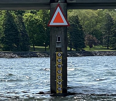
We’ve installed staff gauges on the central pier of the East Bridge at the LaSalle Causeway. These help boat operators safely navigate the secondary channel at the causeway.
The gauges are easy to see and show the vertical clearance between the underside of the bridge and the surface of the water (the clearance height). They are fixed boards with reflective markings on the north and south faces of the pier. They show the vertical clearance height in feet.
We also installed a device that electronically determines the East Bridge vertical clearance for boats. The maximum vertical clearance is shown online (below) and updated every hour. Boaters can check it remotely to help plan their trip through the causeway. Vertical clearance readings are reported during the navigation season only, from approximately mid-April to mid-November.
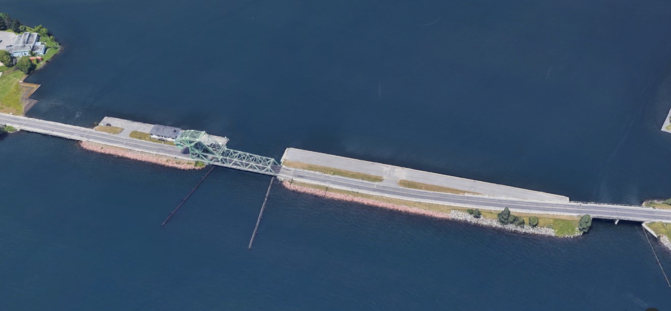
About the causeway
The LaSalle Causeway is considered part of Highway 2, connecting the city of Kingston to its eastern suburbs.
The causeway consists of five interconnecting engineered structures:
- three bridges:
- West Bridge
- East Bridge
- Modular Bridge (replaced the Bascule Bridge, which was removed in 2024)
- two wharfs:
- West Wharf
- East Wharf
The West Bridge and the East Bridge are two fixed bridges located at each end of the causeway. The central channel has a modular bridge structure in place.
The West Wharf features the site office and workshop for the bridge and the operator control station. The operator control station, used for the operation of the demolished Bascule Bridge, is not currently in use.
The LaSalle Causeway links downtown Kingston to Pittsburgh district at the mouth of the Cataraqui River.
The Cataraqui River is the southern entrance to the Rideau Canal, a designated UNESCO World Heritage Site. The LaSalle Causeway provides marine access to the canal and the inner harbour of Kingston. The main navigation channel under the Modular Bridge, which opens on a fixed schedule, is for larger and taller vessels. A secondary channel under the East Bridge is available at all times for smaller and shallower draught vessels.
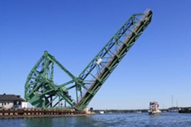
Former Bascule Bridge
The Bascule Bridge previously occupied the main navigation channel. During each navigation season, the bridge lifted to allow marine access to pass.
On March 30, 2024, construction work damaged part of the Bascule Bridge. A diagonal steel truss element that supported the counterweight was compromised. We analyzed the damage and found that key elements of the bridge had shifted out of alignment. This damage would have significantly reduced the bridge’s remaining service life.
After discussions with the City of Kingston, we decided to demolish and remove the entire bridge.
On June 20, 2024, crews demolished and removed the Bascule Bridge. This work reopened the LaSalle Causeway for marine navigation.
Modular Bridge
On October 3, 2024, Public Services and Procurement Canada (PSPC) installed a modular bridge in the main navigation channel. This work reopened the LaSalle Causeway for marine navigation. The new bridge allows vehicles, pedestrians and cyclists to cross the causeway.
About the Modular Bridge
The Modular Bridge is a two-lane pre-fabricated truss bridge. It supports legal vehicle traffic and includes a separate sidewalk for pedestrians. The bridge sits on the existing supporting structures (abutments) of the former Bascule Bridge.
The design allows us to periodically remove and reinstall the bridge to allow marine traffic to use the main navigation channel.
Bridge lift process and safety
Each bridge lift is a planned operation. PSPC manages the work, and its contractor, Priestly Demolition Inc. (PDI), carries it out using specialized marine equipment.
To lift the bridge:
- hydraulic jacks raise the bridge off the abutments
- crews remove water from the supporting barge to make it rise (deballast)
- once the bridge is floating on the barge, a tugboat moves it out of the navigation channel so marine traffic can pass safely
Crews follow the same steps but in reverse to reinstall the bridge.
Engineers inspect the bridge after each lift. They confirm that the structure, alignment and connections meet highway safety standards. Engineers certify the bridge as safe before reopening it to traffic.
We carefully coordinate all lift activities to protect marine navigation, maintain public safety and reduce disruption on the causeway.
Operating costs
The cost to lease and operate the Modular Bridge in 2025 was approximately $4.8 million. This total includes:
- PDI’s contract costs
- PSPC internal costs
Contract information
LaSalle Causeway Bascule Bridge Design Build Demolition – Kingston, Ontario – Award Notice.
Photo gallery
Video: Moving the Modular Bridge for marine access through the LaSalle Causeway
Watch this video to see how the design of the Modular Bridge on the LaSalle Causeway allows us to remove and reinstall it.
Transcript: LaSalle Causeway - Moving the modular bridge for marine access through the LaSalle Causeway
Start of video
[Music plays.]
(Text on screen: Public Services and Procurement Canada)
[Shot of the sign for LaSalle Causeway is shown with cars and pedestrians moving by.]
[Drone shot from above showing the Modular Bridge on the barge being prepared to move.]
[Shot moves across the site showing the work being done and a better look at the boat moving the barge.]
[Shot of a top-down drone time lapse showing the bridge on the barge moving out of the causeway, and pulling out so boats can pass through.]
[Drone shot shows barge and boat in the open water safely out of the main navigation channel.]
[Wide shot shows the boat, barge and bridge off to the side as the main navigation channel is now fully open.]
[Wide shot shows the waterway in use as a sailboat passes through the main navigation channel before fading to white.]
(Text on screen: Check us out, Facebook: /PSPC.SPAC, Instagram: @pspc_spac, X: @pspc_spac, YouTube: PSPC_SPAC.)
(Text on screen: ISBN: 978-0-660-74162-8, Catalogue: P4-158/2024E-MP4)
[Music stops]
(Public Services and Procurement Canada signature)
(Canada Wordmark)
End of video
History of the causeway
The causeway has undergone various structural changes over the years.
Opening of the causeway
- The causeway, in its current form, opened to traffic in 1917
- The Bascule Bridge replaced the 1829 Penny Bridge, a wooden toll bridge with a swing section, allowing marine vessels to pass
- Strauss Bascule Bridge Company of Chicago designed the single-leaf Strauss heel trunnion bascule bridge
- At the time, the East Bridge and West Bridge were single-span through truss structures
Structural upgrades and rehabilitation
- 1969: the East Bridge was replaced with a two-span prestressed concrete voided slab beam bridge
- 1994: the West Bridge was replaced with a two-span prestressed concrete box girder bridge
- 2010: the steel structure and coating of the Bascule Bridge underwent extensive rehabilitation
- 2020: the Bascule Bridge’s mechanical systems were repaired to address the systems’ deficiencies that impacted operations
- 2021: the Bascule Bridge’s structural steel was repaired to address fatigue issues in the truss structure
- 2022: concrete repairs at the abutments were completed
- 2023: construction work began on the Bascule Bridge rehabilitation
- June 2024: the Bascule Bridge was demolished and removed due to damage incurred during construction
- October 2024: a modular bridge was installed to reinstate road access for vehicles, cyclists and pedestrians