
Evaluation of Canada’s meteorological warning services for Arctic Ocean: chapter 4
2.0 Background
2.1 Program Overview
In recognition of the potential for significant increases in Arctic shipping as ice margins recede, the International Maritime Organization (IMO) expanded the Maritime Safety Information (MSI) service of the Global Maritime Distress and Safety System (GMDSS) to the North Pole through the implementation of five new METAREAs. METAREAs are geographical areas established by the IMO to transmit meteorological MSI, comprised of marine weather and ice forecasts and warnings. Two of these areas have been assigned to Russia, and one to Norway. The remaining two areas (XVII and XVIII) are mainly composed of Canadian Arctic waters (including the Canadian Northwest Passage) and a portion of international waters in the High Arctic, but also include waters north of Alaska and along part of the western coast of Greenland.
Figure 1: Circumpolar Arctic Marine METAREA Coverage
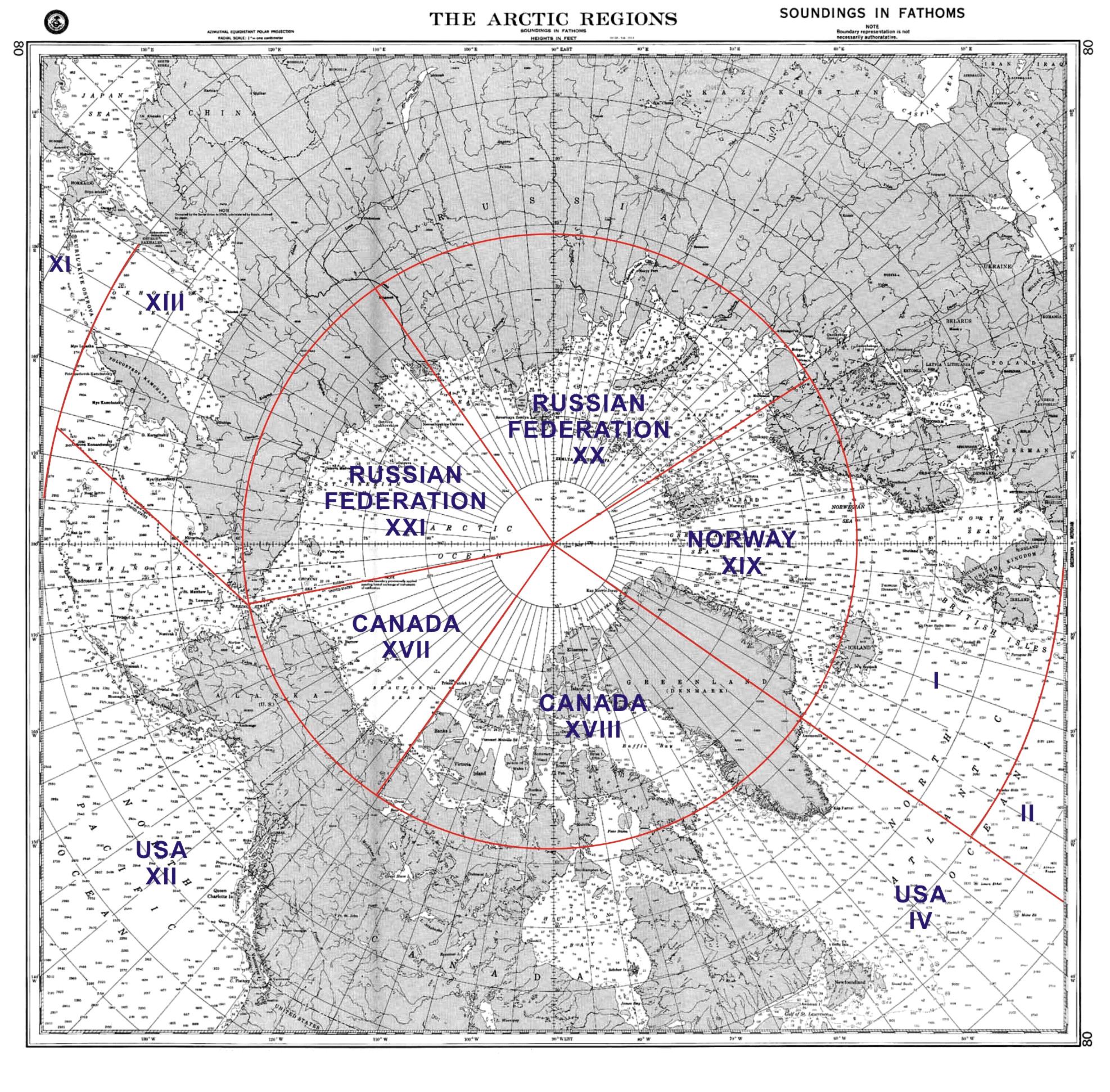
Long description of image 1
Figure 1 provides a map of the five METAREAs, representing circumpolar Arctic marine coverage to the North Pole.
In 2007, with formal approval from the Minister of Fisheries and Oceans and the Deputy Minister of the Environment, Canadian officials informed the international community of Canada’s willingness to take on Arctic METAREA responsibilities. The IMO confirmed Canada as the Issuing Service for METAREAs XVII and XVIII in April 2008. In September 2009, the World Meteorological Organization (WMO) made an international public announcement to this effect. The timetable for implementation of the new Arctic METAREAs required the commencement of test services on July 1, 2010, and prescribed the official launch of circumpolar Arctic METAREA services on June 1, 2011.
The METAREA Initiative is a five-year initiative (2010-11 to 2014-15) to launch services in METAREAs XVII and XVIII for which Canada has accepted responsibility. The goal of the METAREA Initiative is to strengthen safety and promote environmental protection for marine activity in the Arctic.
2.2 Program Delivery
The METAREA Initiative involves five components:
- Expansion of the Meteorological Services of Canada (MSC) weather and ice forecast production system and forecast products and protocols for the provision of METAREA services;
- Science support to enhance and tailor forecast models for the Arctic;
- Installation of monitoring infrastructure (weather stations and buoys) and acquisition of satellite observations to gather data in the METAREAs for forecasting;
- Creation and staffing of weather and ice operational forecast desks to produce the meteorological bulletins; and
- Packaging and dissemination of the bulletins. Each of these is described in more detail below.
Component 1: Service and Platform Design, Development and Implementation
This activity comprises the design, development and implementation of: 1) a forecast production system to enable the production of the weather and ice forecasts unique to the provision of METAREA services. This is required to support the expansion and enhancement of EC’s current localized marine and ice services to include full coverage of METAREAs XVII and XVIII; and 2) the forecast products and protocolsconsistent with formats and standards prescribed by the international community for the provision of METAREA MSI services (e.g., GMDSS broadcast standards). A METAREA specific product was developed to amalgamate this information, ultimately integrating the marine weather, sea-state and ice forecasts and warnings into a single bulletin.
Component 2: Science Support and Technology Transfer
This activity is comprised of the scientific research and technological development efforts related to addressing the unique challenges and complexities posed by the arctic environment which are essential in supporting the implementation and sustainable delivery of EC’s METAREA services in the Arctic. This will include tailoring existing forecast models to be specific to the Arctic (coupling of ice, atmosphere and the ocean) and developing enhanced models to address gaps as a result of expanding services to the vast geography encompassed by METAREAs XVII and XVIII.
Component 3: Monitoring (in-situ and space-based)
This activity involves a modest expansion of EC’s existing environmental monitoring networks to areas where no such infrastructure exists in order to represent the full geography of Arctic METAREAs XVII and XVIII with respect to the provision of the METAREA services. This includes: 1) an expanded and enhancedin-situ monitoringnetwork of automated marine weather stations and an array of buoys in the Arctic.Operating and capital resources were allocated to achieve site readiness, and to procure and install the new environmental observation platforms, including the installation and upgrading of marine weather stations, and deployment of ice and marine buoys; and 2) an increased acquisition ofspace-based observations to complement in-situ observations in the delivery of weather and ice information services for METAREAs XVII and XVIII. Space-based data are obtained from a variety of sources including, but not limited to, RADARSAT (1, 2 and Constellation Missions), and the National Oceanic and Atmospheric Administration (NOAA) and European and Japanese Space Agencies.
Component 4: Operational Desks, including recruitment and training
An operational program has been established for the METAREA forecast activities related to producing the operational meteorological bulletins. This includes establishing two operational forecast desks, one for weather and one for ice. These forecast desks produce weather forecasts for METAREAs XVII and XVIII, as well as sea state and freezing spray forecasts, ice warnings with more in-depth information including ice concentration and type, ice hazards and areas of ice pressure. Within the five years of this Initiative, the goal of the Initiative is to expand these weather, ice and sea-state services to 24/7, year-round coverage for the navigable waters of METAREAs XVII and XVIII. This component includes funding for recruitment and training of personnel for the incremental operational requirements.
Component 5: Product Dissemination
METAREA products generated by the two METAREA operational desks for full METAREA coverage are assembled and packaged into comprehensive METAREA marine and ice bulletins for dissemination to mariners. By the end of the implementation phase, the intention is to merge marine and ice bulletins into a single bulletin. The merged bulletin will be disseminated twice-daily to users throughout METAREAs XVII and XVIII over GMDSS, using the SafetyNET service Inmarsat-C satellite system covering waters up to 75°N, and via Fisheries and Oceans Canada (DFO’s) high frequency (HF) radio telex transmissions in the High Arctic (above 75°N). The bulletin transmissions are monitored to ensure that the messages are indeed successfully broadcast internationally and that Canada meets the GMDSS broadcast standards, responding to issues as they arise.
2.3 Stakeholders
The primary target audiences for the Initiative include Canadian and international safety and security agencies, and international and domestic mariners. Ancillary beneficiaries are the weather-sensitive economic sectors operating in the North, along with Northern residents who will benefit indirectly from the METAREA Initiative through improved data and models for weather and ice forecasting in the North.
Coordination of the METAREA services is through the WMO’s METAREA Coordinator and Canada’s METAREA Coordinator who resides within EC. Through international meetings, service levels and standards are discussed and adjusted as needed.
The implementation of the Initiative involves partnerships with both internal and external organizations:
Environment Canada
- MSC is the responsible Branch within EC for the METAREAs Initiative and directly leads Components 1, 3, and 4. The METAREA Initiative is a service expansion of MSC’s core weather program and, therefore, there are important interrelationships with this program;
- Science and Technology (S&T), responsible for component 2; and
- Corporate Services Branch supports information technology development within Component 1 and provides administrative supports.
Other government departments
- Shared Services Canada (SSC) provides information technology services and support to all components, and has primary responsibility, in conjunction with MSC, for the delivery of component 5, product dissemination;
- DFO/Canadian Coast Guard (CCG) is responsible for the NAVAREA Initiative (production of navigational MSI in the METAREAs). In addition, DFO/CCG transmits METAREA Initiative bulletins North of 75°N using its High Frequency (HF) radio. The DFO Ocean Science group collaborates with EC on ocean-ice-air model and forecast development. DFO/CCG supports the MSC in the deployment of ice and marine buoys and beacons as part of component 3; and
- DND also supports the MSC in the deployment of ice and marine buoys and beacons as part of component 3.
External partners
- Universities, including an agreement with the University of Manitoba for assistance with installation of monitoring equipment (in exchange for access to meteorological data).
2.4 Management Structure
The project management methodology selected by EC to manage this Initiative is called Prince2.Footnote 3 In a Prince2 environment, the responsibility for the overall day-to-day management and administration of the METAREA Initiative rests with the METAREA Project Manager, National Service Operations, Weather and Environmental Prediction and Services, within the constraints laid down by the METAREA Project Board and Project Executive. The Executive is ultimately responsible for the project and represents the organization’s senior business management. The Executive is the ultimate decision maker and is supported in the decision making by the members of the Project Board (senior users and senior suppliers). The Project Board meets twice a year to assess progress and is also convened when an issue is identified that requires a decision by the Board. Highlights reports are produced on a quarterly basis and prior to Project Board meetings.
The five components that comprise the Initiative are each led by a Component Lead. The Component Lead is responsible for specific project coordination. Each component has at least one or more Activity Leads to coordinate the work of the different divisions, sections or units.
2.5 Resource Allocation
The METAREA Initiative is funded for five years (2010-11 to 2014-15) for $26.46 million, as presented in Table 1. The Initiative involved 19.5 full time employees (FTE) for the first fiscal year, increasing to 42.5 FTEs by 2012-13 and is planned to plateau at 34 FTEs by 2014-15.
FTP - Full-time Equivalent
EBP - Employee Benefit Plan
O&M - Operations and Maintenance
PWGSC - Public Works and Government Services
| Fiscal Year | FTP | Salary | EBP | O&M | Capital | PWGSC | Total |
| 2010-11 | 19.5 | 1,586,933 | 317,387 | 674,949 | 320,000 | 150,731 | 3,050,000 |
| 2011-12 | 44.0 | 3,515,095 | 703,019 | 1,821,976 | 380,000 | 339,910 | 6,760,000 |
| 2012-13 | 42.5 | 3,316,119 | 663,224 | 1,703,795 | 0 | 326,862 | 6,010,000 |
| 2013-14 | 35.0 | 2,906,442 | 581,288 | 1,531,100 | 0 | 291,170 | 5,310,000 |
| 2014-15 | 34.0 | 2,928,650 | 585,730 | 1,509,833 | 0 | 305,787 | 5,330,000 |
| Grand total | 14,253,239 | 2,850,648 | 7,241,653 | 700,000 | 1,414,460 | 26,460,000 | |
A detailed comparison of program expenditures and allocations between 2010-11 and 2013-14, excluding costs for EBP, PWGSC and other enablers, is presented in section 4.2.2, Table 3.
2.6 Program Logic Model
The METAREAs Initiative comprises part of the Meteorological and Ice Services in Support of Marine Navigation sub sub-program 2.2.2 in EC’s program activity architecture (PAA). METAREA activities and outputs are expected to result in direct and intermediate outcomes that lead to the following primary final outcomes:
- Canada demonstrates Arctic sovereignty;
- Reduced risk of marine safety incidents in METAREA XVII and XVIII related to meteorological, sea-state and ice conditions; and
- Increased efficiency of marine navigation and economic activities in the North.
The logic model also identifies several direct and intermediate ancillary benefits of the Initiative, called “associated” outcomes, which concern the quality, accessibility, and use of meteorological and ice information for economic sectors and Northern residents. In the longer term, these benefits are expected to result in a:
- Reduced risk to human safety and property from hazardous meteorological, sea-state and ice conditions in the North.
The logic model for the METAREA Initiative is included in Annex 1.