
Learn about hurricanes: hazards and impacts
Quick links to Hazards and Impacts section:
- Wind
- Rain
- Storm surge
- Ocean waves
- Coastal waves
- Five common myths about hurricane waves
- Rip currents
When most tropical cyclones arrive in Canada or in Canadian waters they are in some stage of extratropical transition (ET). Even Hurricane Juan (2003), which stayed more tropical than most tropical cyclones when it reached Canada, was still undergoing ET. This is important because the weather and impacts from a transitioning tropical cyclone are different than those from the purely tropical cyclone. The weather is also different from a purely extratropical storm systems that are common in Canada.
Here is what you might expect with “post-tropical” cyclones.
Wind
The wind is usually affected in three ways when tropical cyclones go through extratropical transition:
- The maximum wind speed drops off (although not always by very much).
- The maximum wind moves farther out from the storm centre, on the right side of the storm (looking downwind).
- The area of gale-force winds (> 63 km/h) gets bigger, sometimes by a lot.
A general rule with tropical cyclones is that the wind on the right side of the storm is stronger than on the left side of the storm by twice the value of the storm’s speed of motion. For example, a tropical storm moving at 15 km/h will have winds that are 30 km/h stronger on the right side of the storm than on the left. Once tropical cyclones begin to transition, the difference in winds from one side to the other is about the same as the storm’s speed. Hurricane Juan (2003) was early in its transition when it made landfall at a speed of 55 km/h. The winds just west of the track (left-hand side) were about 100 km/h, while the maximum winds east of the track (right-hand side) were close to 160 km/h.
Here are pictures of Point Pleasant Park in Halifax, before and after Hurricane Juan (2003). Ninety percent of the mature growth of the park was destroyed by the marginal Category 2 winds of 155 km/h and gusts to 200 km/h in exposed locations.
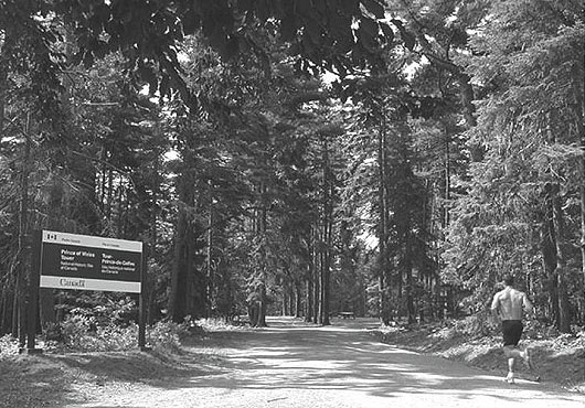
Point Pleasant Park in Halifax, before Hurricane Juan (2003)
Photo credit: Parks and Open Spaces, HRM
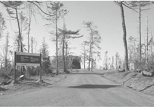
Point Pleasant Park in Halifax, after Hurricane Juan (2003)
Photo credit: Parks and Open Spaces, HRM
The degree of wind damage to structures depends on many factors: whether the structure is built to building codes, the condition of the structure, the type of structure, etc. Wind speeds increase dramatically with height during tropical events. Winds of Category 1 strength at ground level may increase to near Category 2 strength at the top of a high-rise building.
Similarly, the potential for damage to trees depends on several factors, including tree type and rooting structure, soil conditions (dry or wet) and, for deciduous trees, whether or not they are in full leaf. The risks to power lines are closely connected to the vulnerability of the trees in the area. Breaking limbs and falling trees are the prime source of downed power lines during tropical and post-tropical wind events.
The following table is a helpful guide that gives an idea of the types of damage different wind strengths can cause in eastern Canada (based on past post-tropical storms and hurricanes).
| Wind Speed (Gusts) | Typical Impacts |
|---|---|
| 70-90 km/h | Small branches break, loose objects blown about, possible power outages |
| 90-100 km/h | Some tree limbs break, occasional trees topple, some poorly constructed signage damaged, power outages |
| 100-120 km/h | Prevalent tree branch breakage, some trees topple, some shingle and siding damage to homes, power outages |
| 120-140 km/h | Many trees toppled / uprooted, many signs damaged/destroyed, glass in high-rise buildings can break, widespread power outages possible |
| 140 km/h + | Widespread forest blow-downs, prevalent cladding and roofing damage, some roofs blown off / heavily damaged, widespread power outages possible |
Post-tropical Storm Florence (2006) was a large storm system that brought hurricane-force winds to the south coast of Newfoundland. This newly constructed home in the town of François was blown off its foundation and destroyed by the high winds.
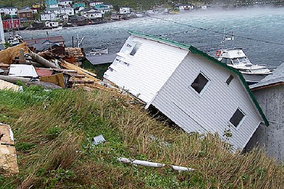
Post-tropical storm Florence (2006) destroys newly built home in Newfoundland.
© Environment Canada. Photo: James Durnford
Rain
The intense rainfalls from tropical and post-tropical cyclones are in many ways of more concern than high wind events for Canada because they happen much more often. A 1970-1999 American study showed that about 60% of tropical cyclone-related deaths in that country were a result of the freshwater inland flooding caused by intense rainfalls.
Contrary to what many may think, with tropical systems there is very little connection between storm intensity and rainfall rates or amounts. The intensity and stage of development of a tropical cyclone depends on its wind strength and says nothing about the rainfall. Tropical depressions (with winds well below gale strength) can bring as much rain as a hurricane.
When tropical cyclones undergo extratropical transition, the symmetric rain bands around the cyclone shift to a larger area of rain that is almost entirely to the left of the storm track. This changing rain pattern shows that transition is taking place. Regardless of the amount of rain, the intensity of the rainfall with these systems is the same as in thunderstorms. Rainfalls of 25-50 mm in just a few hours are possible. In fact, rainfall intensities of 20-50 mm per hour are not uncommon, and near-zero visibility and sudden free-standing water can make driving very dangerous. In 2008, Post-tropical Storm Hanna brought about 140 mm of rain to the Fundy Coast of southwestern New Brunswick in about 12 hours. The city of Saint John experienced some of its worst flooding in decades, as seen in the photograph below.
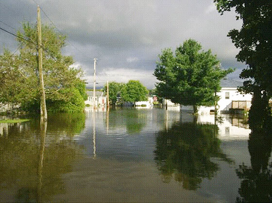
Flooding on Walter Street in Saint John, NB, caused by Post-tropical Storm Hanna in 2008.
© Environment Canada. Photo: Cheryl Killam
Very often the rainfall with post-tropical systems is enhanced by a frontal system already in the vicinity when the tropical cyclone arrives. The high moisture content of the tropical cyclone gets drawn into this frontal system. The atmosphere then “wrings out” this moisture, dumping it as intense rain.
In 1999, the minor remnants of Tropical Storm Harvey drifted up the eastern seaboard of the United States. The winds were very weak, but all of its tropical moisture was still intact. When Harvey arrived in the Maritimes, a stalled front throughout Nova Scotia was all that was needed to create widespread heavy rain. A maximum rainfall of more than 300 mm fell at Oxford, Nova Scotia (see map).
Canada’s most memorable hurricane is Hurricane Hazel (1954). Eighty-one people were killed by flooding in Toronto when the Humber River overflowed its banks during a night of intense rains that brought more than 200 mm.
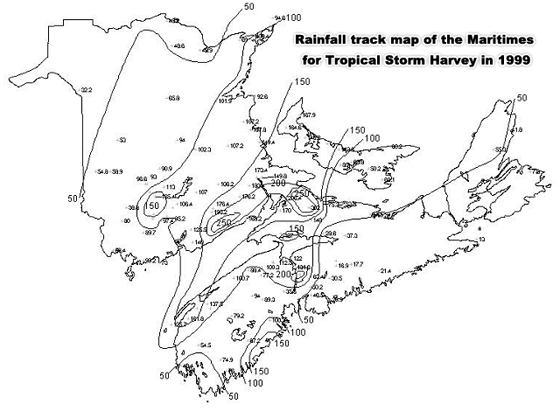
Rainfall track map of the Maritimes for Tropical Storm Harvey in 1999
Storm surge
Our American neighbours have a great slogan to help promote hurricane preparedness and response:
“Hide from the wind--run from the water.”
Recent statistics show that most tropical cyclone-related deaths in the United States are now caused by inland flooding. However, this isn’t because the coastal threats have lessened. It’s because people now leave coastal areas when they are warned. Better hurricane warnings over recent years have saved countless lives. Now with enough warning, people “run from the water” at the coast and head inland where they then “hide from the wind.”
Storm surge is the water threat that happens at the coast, and it’s the greatest hurricane hazard for those on land. A storm surge is an onshore pileup of ocean water, or lake water, that is caused by a combination of high winds and low pressure. Storm surges occur both with tropical cyclones (like hurricanes) or extratropical cyclones (like winter storms). The lower central pressure of the storm causes the ocean to rise up, much the way a carpet bulges underneath a vacuum moving across it. It is sometimes assumed that this effect is the main factor in storm surges associated with hurricanes. In fact, it is the wind ahead of the hurricane that is key in causing large surges at the coastline; 75% or more of the surge is the result of the wind, not the low pressure.
A simple and general rule-of-thumb for estimating a storm's low pressure contribution to the surge is as follows: 1 cm of rise above predicted tidal values for each hectopascal (hPa) below the standard atmospheric pressure of 1013 hPa. For example, Hurricane Juan (2003) had a central pressure of 974 hPa when it made landfall just west of Halifax Harbour. The pressure effect alone would have resulted in a surge of approximately 39 cm. However, the surge measured in Halifax Harbour was about 150 cm. Clearly, a more important mechanism was at work.
The wind is the key. As a hurricane approaches a coastline, the very strong pressure gradient (a large difference in atmospheric pressure over a small area of geography) pushes the ocean surface ahead of the storm and predominantly to the right side of the track. Other factors such as the speed of the storm's motion, the angle at which the storm makes landfall with the coast, and the coastal bathymetry (the shape of the seabed) all help determine the specific storm surge experienced at each point along the coast. But wind is the most important factor.
Four independent events have to happen for a "worst-case scenario" surge event to occur in Atlantic Canada: a spring tide, a lunar perigee, a daily high tide and a powerful storm. See how these lined up for Hurricane Juan
Picture of storm-surge damage from Hurricane Juan (2003). The high water eroded the ground under the rail tracks and toppled tanker cars into Halifax Harbour.
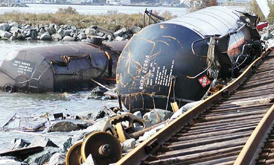
Storm surge from Hurricane Juan (2003) washed rail cars into Halifax Harbour.
© Environment Canada, 2003 Photo: Roger Percy and Andre Laflamme
Ocean waves
While storm surge remains the greatest hurricane hazard for those on land, high waves are the greatest hurricane threat for those at sea. Canadian statistics show that between1900 and 1950, 75% of the deaths caused by Canadian tropical cyclones happened at sea. Since 1950, that number has dropped to about 25%.
However, similar to the reasoning behind the shift in American fatality statistics, this doesn’t mean that it is any safer now at sea during a tropical cyclone than it used to be. It simply means that mariners are being effectively warned and that they are taking actions to protect themselves. Tropical storms and hurricanes are still very dangerous storm systems, and mariners need to understand the nature of the threat.
Tropical cyclones are generally much smaller than our typical mid-latitude weather systems, so the area of disturbed seas is also generally much smaller. But this doesn’t mean that the wave heights are lower. Just the opposite is true. Some of the highest and fastest-building ocean waves ever measured in the world have been seen in Canadian waters during tropical cyclones.
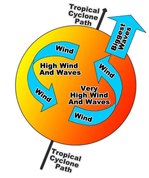
Illustration of a tropical cyclone wind path. Stronger winds and waves occur to the right of the storm centre.
© Environment Canada, 2009
Ocean waves are made by the wind. Since a hurricane is a powerful wind machine, it acts much like a giant egg beater in the water, churning up the seas and sending waves off in all directions. As the storm system moves in a given direction, the wind to the right side of the storm’s motion generates waves moving in the same direction. On the left side of the storm’s path, the waves are moving in the opposite direction. The waves to the right of the storm are able to stay with their generating winds much longer and therefore get much bigger than those to the left.
Coastal waves
In November 2007, Hurricane Noel changed into an enormous post-tropical storm and headed directly towards Nova Scotia. The entire Atlantic coast of Nova Scotia saw hurricane-force wind gusts of 135-140 km/h and the most damaging wave conditions experienced in a couple of generations. The waves were so damaging that the Geological Survey of Canada created a special website to record the coastal impacts of Post-tropical Storm Noel. In Halifax, the wave-rider buoy recorded significant wave heights of about 15 m, but the worst conditions were just west of the city, near Peggy’s Cove, where significant waves of more than 17 m came ashore.
Extreme storm waves are nothing new to Peggy’s Cove. In 1915, a breakwater was erected to help lessen the effects of violent waves. This breakwater was overtopped during Hurricane Juan (2003) when waves came in from the southeast, but it was destroyed during Post-tropical Storm Noel when waves approached from the southwest. This was more proof of the size and power of Noel’s waves because the breakwater is almost twice the distance inland when approached from the southwest than from the southeast.
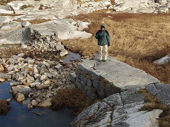
Water destruction at Peggy's Cove from Hurricane Juan (2003).
© Environment Canada Photo: Doug Mercer
Five common myths about hurricane waves
Myth 1: Waves are bigger on the right side of the hurricane because the wind is stronger on the right.
In reality, it is the motion of the waves that really explains why waves on the right side of the storm can be twice the height of those on the left. Waves to the right move in harmony with the storm and remain under the strong winds. To the left of the storm, the waves move in the opposite direction and quickly fall behind.
Myth 2: Waves are calm in the eye of the storm.
The eye of a hurricane has calm winds and often clear skies. However, the ocean waves are anything but calm. Winds rotate counter-clockwise around all cyclones and generally spiral slightly toward the centre. Therefore, since waves move in the direction of the winds that generate them, waves that are generated just outside the eye (in the strong winds of the eyewall) are actually directed slightly towards the centre. Even though the winds drop off to zero near the centre of the storm, the waves keep moving in the same direction once they have been created. In slow-moving or nearly stationary hurricanes, waves will tend to move towards the centre of the storm, creating sometimes mountainous waves that come in from all directions. Such chaotic seas, which have no apparent direction, are the hardest to navigate. So, while the eye of the storm may be fine for birds and insects gathering up high where the winds are calm, the sea surface is no place for a ship to try to ride out the storm.
Myth 3: “The dangerous versus navigable semicircle.”
Some older books on marine navigation (and even some newer ones) often refer to two semicircles within a hurricane: the dangerous semicircle and the navigable semicircle (divided as shown in the graphic above). This description might lead some to think that the navigable semicircle isn’t dangerous. This couldn’t be further from the truth. If a hurricane-encounter at sea cannot be avoided, then it is better to be to the left of the storm’s path because this side is more navigable. However, it is still dangerous because of the high gusty winds and often chaotic seas, especially closer to the centre of the storm. Both semicircles are dangerous - it’s a hurricane!
Myth 4: Hurricanes “telegraph” their approach by sending ocean swells ahead of them.
Again, many marine navigation books teach that one of the “saving graces” of hurricanes is that they let you know they are coming by sending large ocean swells out ahead to announce their arrival. In many cases, these swells begin to arrive days before the actual storm. This is not a myth and works quite well for slow-moving storms. However this is seldom, if ever, true in Canada because hurricanes moving into mid-latitudes move much quicker than their tropical counterparts (forward speeds of Canadian hurricanes can be two to three times that of similar storms in tropical latitudes). Slow moving hurricanes generate large waves which move quickly out ahead of the slower moving storm. Faster moving storms generate large waves which can move at the same speed as the waves which they generate. In this case the waves and storm arrive at the same time because the waves are “trapped” within the fetch of the storm (the area of winds which creates the waves).
These “trapped-fetch” waves have been a point of close study and modeling at the Canadian Hurricane Centre since Hurricane Luis (1995). Luis created phenomenal waves which were measured by both a Canadian NOMAD Buoy and the QEII Luxury Liner. The maximum wave height measured was over 30 metres tall (100 feet).
One of the best examples of “trapped-fetch” waves was with Hurricane Danielle (1998). The graph below shows both significant and maximum wave heights. The “significant waves”, or the average of the highest one-third of waves, measured in Danielle by a NOMAD buoy, grew from 7 m to 16 m in only two hours, arriving with the storm almost like a “wall of waves”.
In Hurricane Juan (2003) members of the public reported that “a wall of water/waves” moved up Halifax Harbour when the height of the storm arrived. Trapped-fetch waves don’t let you know that the storm is coming.
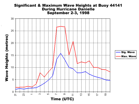
Graph showing the significant and maximum wave heights at Buoy 44141 during Hurricane Danielle September 2-3, 1998
Myth 5: Stronger storms make bigger waves.
Ocean waves are created by wind. The size of waves depends on three factors: the strength of the wind, the size of the area of wind (where the wind speed and direction are more or less the same...known as the “fetch”), and the time needed for that uniform wind to build waves. Many people think that wind strength is the most important factor in making big waves. However, in the case of smaller storm systems like tropical cyclones, the fetch is just as important. This has been proven many times when weaker tropical systems moving through Canadian waters have created waves as big as those seen with major hurricanes in the tropics. A Category 1 hurricane with “trapped-fetch” waves can have waves just as big as those with a Category 4 hurricane in the tropics. Actually, these waves in Canadian waters can be worse because they come at the same time as the storm and therefore give no early warning that a hurricane is coming. They are also part of a fast-moving storm system which is moving two to three times faster than those in the tropics and can travel from the Carolinas to Maritime waters in a day.
Rip Currents
Longshore currents are created by waves breaking at an angle to the shore. They are most common with waves that have long periods or wavelengths (waves with a long time and distance between successive crests) which occur with strong long-lived wind systems such as strong tropical storms or hurricanes. If the bathymetry (seabed) of the beach is irregular, waves become concentrated in some areas because of an effect known as refraction. Refraction causes waves to “bend” towards points or headlands where they build higher in those areas. The longshore currents farthest from the region of largest breakers are strongest. The water that has built up in the surf-zone through the action of the breakers eventually returns to the sea, often in strong narrow currents called rip currents (sometimes called rip tides).
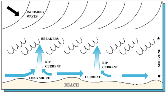
Illustration showing how rip currents form.
© Environment Canada, 2009
Rip currents can reach speeds of 4-6 km/h and are signposted on some beaches because they are dangerous. Unsuspecting swimmers caught in a rip current can fight the current to the point of exhaustion and make no headway. A swimmer carried seaward by a rip current should not struggle against it, but swim across it, parallel to the beach. Once out of the narrow rip current, the waves will tend to carry the swimmer shoreward.