Canada's top 10 weather stories for 2014: chapter 6
6. Hurricane Arthur and Others
The Atlantic hurricane season was quiet as forecasted, with eight ‘named’ storms forming in the Atlantic basin. While this fell below the recent long-term average of 11, six were hurricanes and two of those - Edouard and Gonzalo - were considered major. The season’s first hurricane, Arthur, came relatively early for a significant hurricane, while Gonzalo, the last hurricane, marked an early end to the season. Both storms were the most punishing ones of the season in Atlantic Canada.
Arthur developed from a low-pressure centre over the southeastern United States in late June. By July 1, it became sufficiently organized and strengthened to hit tropical storm status. Drifting northward, it reached hurricane strength on July 3, attaining Category 2 status with peak winds of 160 km/h late in the evening. Arthur made landfall near Beaufort, North Carolina, then accelerated northward and weakened as it passed by Cape Cod. Transitioning into a post-tropical storm, it barrelled into the southwestern part of Nova Scotia on July 4 with might. Chris Fogarty, manager of Environment Canada’s Canadian Hurricane Centre in Dartmouth, Nova Scotia, called Arthur “a nor’easter, with attitude.” Its slower speed gave it time to inflict a longer punch - 12 hours to track from just north of Yarmouth to near Prince Edward Island. Arthur made landfall near Metaghan, N.S. and moved northeastward to the Fundy coast before crossing into western P.E.I., bringing heavy rains of as much as 150 mm. The remnants of Arthur also affected the Gaspésie region of Quebec where soaking rains topped 80 mm and lashing winds reached 100 km/h. The town of Carleton-sur-Mer in Chaleur Bay was especially hard hit with power outages, uprooted trees, damaged houses and capsized sailboats. In Marsoui, near Sainte-Anne-des-Monts, the river burst its banks, flooding roads and highways and inundating 20 homes.

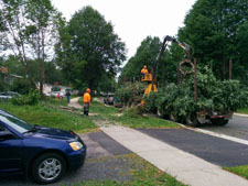
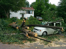
In New Brunswick, Arthur’s winds topped 100 km/h and it rained hard. Along the Fundy shoreline in St. Stephen it rained so hard (over 150 mm) that you couldn’t see three metres ahead. In Nova Scotia, Greenwood was hit worst with wind gusts close to 140 km/h. On the province’s southwestern and eastern shores, five- to seven-metre waves pounded with a huge surf that set off rip currents. Power outages were the lasting impact of Arthur’s remains. Utility workers in the Maritimes aided by crews from Quebec and Maine faced a herculean undertaking in repairing transmission and distribution systems. Nova Scotia’s utility admitted that the damage inflicted by Arthur was equal to that left by Hurricane Juan more than 11 years earlier. At the storm’s peak in Nova Scotia, the wet and windy wallop toppled trees and knocked out power for more than 144,000 homes and businesses; some lost services for up to eight days. In New Brunswick, the storm took out power for 140,000 NB Power customers − more than 60 per cent of the utility’s clientele. It was the third time that there were multiple days with lost power in the last 16 months with Arthur unleashing more damage to infrastructure from rains and winds than any other storm in the utility’s history. It took as much as 18 days to reconnect power to all households and businesses.
Arthur was well forecasted, but in the end it had a few surprises - among them the slowness of its departure and stronger winds where the threat is usually rain and more rains where the winds are usually the issue. The storm terminated flights in the Maritimes and forced the cancellation of several festivals and blood donor clinics. Road travel was disrupted because of fallen tree debris and flooded surfaces. Hurricane-force winds and rains beat back some strawberry plants and grain stalks and washed away potato seedlings, although the earliness of the storm allowed some early plantings to avoid the blow-over and drenching. Trees were especially vulnerable due to June’s above-average rainfall that meant rootballs were sitting in highly saturated ground from which they could be more easily lifted.

The season also featured other tropical storms. Just ahead of Tropical Storm Bertha on August 8, the Maritimes experienced some strong gusty winds, heavy rain and pea- to dime-sized hail across parts of Nova Scotia, while a funnel cloud or two made their way across Cape Breton Island. On August 29, Hurricane Cristobal tracked northeastward across the southeastern Grand Banks bringing rainy weather to the Avalon Peninsula. Significant rainfall amounts also occurred over the southern part of the Gaspé in Quebec where Chandler recorded 50 mm of rain.

Hurricane Gonzalo wrapped things up for the season, starting on October 18 when it launched an hours-long attack on tiny Bermuda as a Category-3 hurricane. From there, it quickly moved northward over the Atlantic Ocean on a track that took it just 540 km southwest of Cape Race, Newfoundland on October 19 with maximum sustained winds of 140 km/h. Fortunately, it gave the province a pass, staying offshore before racing out into the North Atlantic where it would eventually affect Europe and end in Greece. The Avalon Peninsula got quite a soaking for two to three hours with 50 mm in all. Off the coast of Newfoundland, exploration companies took extra precautions with oil installations, but weather conditions − 10-metre waves and 100 km/h winds − were not serious enough to order worker evacuations. While most Newfoundlanders simply slept through the worst of Gonzalo, there were other impacts. Participants of this year’s Cape to Cabot half marathon - a race that bills itself as one of the toughest in Canada - faced even tougher conditions, with sections of the hilly terrain washed out and strong in-your-face winds adding to the experience. And on the Atlantic coast of Nova Scotia there were high seas and rip currents from Shelburne to Louisburg.