
Reducing flood damage
In this Section:
Historical Background
The following section traces the evolution of the roles of governments in providing flood control and assistance up to the current national policy for flood damage reduction implemented through the federal-provincial/territorial Flood Damage Reduction Program.
Before 1953
Water has always played a major role in the life and development of Canada. Commencing in the late-1630s, French settlers in the Bay of Fundy area of Atlantic Canada constructed a system of dykes to reclaim the salt marshes for their agricultural productivity. Over 200 years later, in the early development of British Columbia, sea dykes were constructed to protect and reclaim agricultural land. The frequency of such dyking by private individuals led to legislation to form organized dyking districts by the British Columbia Government in 1873.
With the influx of settlers to the country, water became of greater consequence in daily life, for transportation, energy, trade, territorial control, and military purposes. Although no major disasters are known to have occurred, a look at flooding at that time would show failure of small dams, loss of bridges, and inundations of large parts of villages and towns.
Communities and industries sprang up along the water courses, since they provided the principal means of transportation and were a source of water supply. As the country developed the water resources were found to provide additional benefits. By the late-1800s, Canadian rivers were being promoted in literature enticing European sport fishermen. Their recreational importance continued to grow with the turn of the century. At the same time, the hydroelectric potential of the country was beginning to be realized.
In the early part of the 20th century, large-scale water control projects, mostly for hydroelectric generation, were constructed. Although these were not built for flood control purposes, they invariably lowered flood peaks. Works constructed for navigation purposes could also reduce flood peaks, but to a lesser degree. Later, the need emerged for a multi-purpose river basin approach, resulting in the formation of Conservation Authorities in Ontario and the Eastern Rockies Conservation Board in Alberta. The authorities were formed on the basis of drainage basins, with a major focus being flood control. Other concerns were water supply for irrigation and domestic use, forestry practices, wildlife, and recreation.
All this activity was being carried out without a particular water policy in place. The British North America Act of 1867 (now known as the Constitution Act) did not specifically mention water. However, this Act, subsequent court battles, federal-provincial agreements, and the natural resources transfer acts of 1930 gave ownership and control of natural resources to the provinces while investing the federal government with legislative power over fisheries, navigation, treaty-making, and extra-provincial undertakings, among other activities. Agriculture fell under both federal and provincial jurisdiction. Flood control, however, was not specifically mentioned.
Therefore, the provinces, while having the power to manage natural resources within their boundaries, were not without restrictions when entering into areas of federal legislative control. Within the federal government, water responsibilities were spread out among several agencies and acts. Their interests were directed toward fisheries; navigable waterways; irrigation; various surveys of rivers, lakes, harbours and dams; hydroelectric development; and treaties with the United States.
Canada Water Conservation Assistance Act
The Canada Water Conservation Assistance Act, promulgated in 1953, was the first federal legislation directly concerned with water resource management. The Act enabled the federal government to provide financial assistance to the provinces in the construction of works for the conservation and control of water. The intention was to provide assistance for projects that normally would exceed the financial means of the province and municipalities. Under the Act, the federal government would contribute up to 37.5% of the cost of such works, provided that the federal contribution did not exceed that of the province.
Canada Water Act
Passed in 1970, the Canada Water Act superseded the Canada Water Conservation Assistance Act as the main vehicle for federal involvement in the management of Canada's water resources. Under the Act, the federal government may participate in water resource management programs and water quality programs with one or more of the provinces. For any waters where there is a significant national interest, agreements with the provinces/territories may be entered into to collect data, conduct research, formulate comprehensive water management plans, and design and implement water management projects.
The Canada Water Act reflects the change in attitudes by resource managers, policymakers, and the public concerning the management of water resources. A new act was required to replace the Canada Water Conservation Assistance Act, which was considered to be too restrictive for the following reasons:
- many uses of water were not covered;
- assistance was provided only for works, thereby disregarding other solutions;
- assistance was given only on the basis of a rigid cost-sharing formula;
- opportunities were not provided for joint consultation on priorities nor for joint participation in planning.
The philosophy of the Canada Water Act encompassed the following emerging ideas:
- planning should proceed on a more comprehensive basis by including all water uses and their economic, social and environmental importance;
- views of the people affected should be sought;
- non-structural alternatives should be considered;
- planning should take place according to river basin or on the basis of other larger geographical areas.
The comprehensive water resources management features of the Canada Water Act provide for a system of federal-provincial Consultative Committees whereby problems, priorities, policies and programs can be discussed among officials of the two provisions of the Act provide for joint agreements for comprehensive planning of individual river basins, and following consideration of such plans, joint agreement on their implementation.
Flooding was one problem in many parts of the country that called for a new approach, beyond the traditional one of employing structural works and paying disaster assistance. This evolution of thought was engendered by the long-standing dissatisfaction with many aspects of the structural approach; the issue of "income transfer" from the general public to the minority of floodplain dwellers; the changing social values, urbanization trends, and economic conditions; and finally, the seemingly endless escalation in flood damage costs even with the implementation of control structures.
In response to these concerns, the federal government decided to evaluate its programs and policies, with a view to formulating a new national strategy to counteract the problems of floods and flood damage. During the assessment, views were solicited from provincial agencies through discussions in the Consultative Committees, from the recommendations of join basin study reports, and from the American experience in approaching the problems of mounting flood losses. Based on this information, the Flood Damage Reduction Program was established in 1975.
Non-Structural and Structural Measures
Governments have attempted to alleviate flood situations in Canada by building protective dykes and creating upstream storage, and through emergency aid and disaster assistance. Although many of these measures are beneficial, they also serve to encourage further encroachment upon river floodplains, thereby raising the potential for flood damage and leading to requests for greater levels of protection. Moreover, as the memory of past events recedes, there is a tendency to ignore the maintenance of existing control works, and to allow new development upstream, increasing the likelihood of flood damage.
In other words, the structural solution is only a partial one; the only long-term solution consists of keeping flood-vulnerable development and uses out of the floodplain. This non-structural approach has gained wide acceptance, since it reduces the need for expensive flood control structures and the demand for disaster assistance payments caused by flood damage. The approach includes:
- regulating land use in the floodplain;
- floodproofing measures;
- acquiring property in the floodplain or relocating structures;
- altering upstream land management practices; and
- establishing and maintaining flood forecasting and warning systems.
Non-Structural Measures
Floodplain management
Floodplain management incorporates an integrated approach to protecting the floodplain from further damages. It entails dealing with existing flooding problems and eliminating increases in the level of potential damage from further development.
Since flooding and erosion are natural processes that are extremely difficult and costly to combat directly, the management and planning of floodplains is a reasonable alternative to ensure public safety and reduce the cost of damages.
Floodplain management typically involves the adoption of land use regulations for identified floodplains. Land use regulations are based on the premise that the specified hazard area will continue to be flooded on occasion. The intention of land regulation is to restrict or direct the use of the land to activities and structures amenable to such occurrences. This non-structural approach is accomplished by reserving or zoning the lands for such purposes and is the least costly method of flood damage reduction if implemented prior to major development of the floodplain. Land acquisition in the floodplain is another method of controlling land use. It has an advantage over legislative restrictions in that the agency involved has direct control over development within the area.
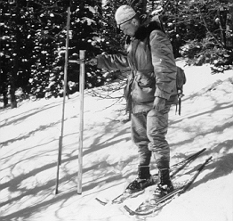
Flood forecasting and warning
Over the past 40 years, flood forecasting and warning in Canada has evolved into a network of forecast systems across the country. There are five provincial streamflow forecast centres:
- Saint John River Forecast Centre,
- Ontario Flood Forecasting and Warning System,
- Manitoba River Forecast Centre,
- Saskatchewan's River Forecast Centre, and
- Alberta's River Forecast Centre.
In addition to these provincial centres, there are a number of other flood forecasting operations such as those of Ontario's Conservation Authorities.
Systematic river forecasting has often been initiated in the aftermath of a particular flood event. In Manitoba, river forecasting was started following the widespread flooding of the Red River in 1950, and in Ontario, a flood forecasting system was developed following the devastating impact of Hurricane Hazel in 1954.
Most of the centres provide multiple services and operate on a year-round basis. While spring flood forecasting may be their primary role and usually their busiest time of year, centres provide year-round streamflow forecasts for flood control and water management. Streamflow forecasts outside the flood season are used to regulate reservoirs and streams for hydroelectric power, irrigation, domestic uses, pollution assimilation, recreation and other low-flow augmentation purposes. For instance, the Saskatchewan River Forecast Centre monitors and controls international and interprovincial flows to meet requirements under various agreements.
The purpose of flood forecasting is to provide as much advance warning as possible of an impending flood. Over time, the demands for flood forecasts have changed from a simple indication of the likelihood or severity of flooding to an accurate prediction of magnitude and timing of flood passage.
Flood forecasting systems generally have a similar operational set-up to carry out the following activities:
- collecting and managing pertinent data;
- developing river forecasting procedures;
- providing advice for flood control operations (also floodway operations, emergency dyking, etc.); and
- communicating flood warnings.
Forecasting is becoming increasingly sophisticated, particularly in the areas of data collection and modelling. However, these activities vary in individual forecasting centres depending on the funds available and the need for increased technology.
Data collection and management
To forecast river or lake flood levels, two primary types of data are required: hydrologic and meteorologic. The following data are required for forecasting flood levels:
- Precipitation: measured at least daily, indicates the gross amount of water applied to the land surface. Cumulative winter precipitation may be used as an alternative to snowpack if winter melt and sublimation losses are considered. Rainfall often contributes greatly to flooding.
- Hydrometric data: data on river levels and flows and lake levels. By monitoring upstream water levels and flows, the forecasters obtain an early indication of the timing and amount of the spring runoff. This facilitates forecasting for downstream areas.
- Soil moisture: data indicating the moisture content of the soil and, conversely, how much may be absorbed by the soil. The amount of water not absorbed runs off the land into streams.
- Snowpack: measurements of snow depth, snowpack water equivalent and snow-covered area. Snowpack data permit the estimation of available water that may contribute to flooding.
- Temperature: measured at least daily, allows for the estimation of the rate of melt of the snowpack and therefore the amount of water being released.
- Wind: speed, direction and duration determine extent of wind set-up and wave uprush which, when superimposed on high water levels, can cause dyke failure, shoreline damage, etc.
- Evaporation: difficult to measure directly. It is computed using other variables such as temperature, wind, and the amount of solar radiation. Evaporation is estimated for slowly responding systems such as the Great Lakes, where evaporation can have a significant impact.
Forecast centre computers and teleprinters are often used to access other agencies' information. For instance, the computer systems of the Meteorological Service of Canada (Environment Canada) are accessed for meteorological data, weather forecasts, and radar maps.
Techniques and procedures
The objective of flood forecasting is to interpret the data collected, estimate the amount of runoff that will occur, and predict water levels in the damage-prone areas of drainage basins spatially and temporally. In doing so, the forecaster can then identify when and where problems could occur.
Flood forecasting employs procedures to estimate the timing and magnitude of peak flows at specific locations. There are a number of hydrologic forecast models in operational use in the world, several of which are in Canada. No one model is suitable for all drainage systems. The models have varying levels of complexity, which are reflected in their requirements for different types and amounts of data. Research is being carried out to test the suitability of many of the models and to determine the appropriate ones for various drainage systems.
The model used by a forecasting unit is dependent upon the data available, hydrologic expertise, available funding, and on the type of watersheds and the specific nature of the problem. Many centres run several models either in parallel or in series.
See also: Water Modelling section
Flood control operations
Forecast centres function closely with agencies involved in the operation of control structures. The agencies are often operating the control structures for purposes other than flood control. Centres provide such users with information about the expected volumes and discharge rates of rivers. They also warn of potential upstream and downstream flood problems.
It is the responsibility of the control structure operators to determine the outlet discharge rate based on the information they have received. Changes to discharge rates are coordinated with the forecast centre and downstream control structure operators and other interests. Any changes to discharge rates are then input to the forecasting model.
Flood event communications
As the ultimate purpose of a flood forecasting unit is to provide flood warnings, the dissemination of information is an integral part of the unit's duties. Generally, a forecasting unit is responsible for notifying the emergency measures agencies, senior government officials, and the public through the media. Ordinarily, the responsibility for flood warnings lies with the provinces and the territories.
There are several forms and levels of flood warnings given to the public and emergency agencies to prepare them for flooding. The warning system is usually initiated with a statement or flood alert early in the season. The alert often gives a general indication of the potential threat based on various weather scenarios. The statements are often printed in the local papers or broadcast on the radio or television. This notice serves to remind responsible agencies, such as the emergency measures organizations, that the flood season is approaching, allowing them to prepare themselves. At this point, the floodplain residents should plan how they could protect their property and valuables.
During the course of the spring melt the forecasting unit will issue a flood warning when a flood event is foreseen. The warning triggers municipal and regional contingency plans to be put into effect by police, fire, public works, emergency measures, and other departments. These agencies would assist in the evacuation, sheltering, feeding and clothing of the threatened population; sandbagging operations; ice jam management; and the operation of flood control structures. These warnings also give the public from several hours to a couple of days to prepare themselves by moving valuables to higher ground, possibly sealing the home to some extent, and volunteering to aid in the flood fighting.
Some jurisdictions mobilize people to knock on doors to warn residents that the river is topping its banks. At this late stage, people only have time to evacuate.
There are limits to forecasting operations. Often smaller streams are not monitored, or sudden ice jams can occur. This can cause flooding that is not predictable by flood forecasters.
Emergency measures
The Boy Scouts' familiar "Be Prepared" is a motto we should all keep in mind when it comes to flooding. For those who live and work near rivers or lakes, flooding is a fact of life. Although we attempt to minimize the effects of flooding, it is impossible to prevent floods altogether. Being prepared for flooding and having emergency plans must therefore be a priority both for residents and for the local officials who are responsible for the safety of their communities.
Preparing for floods is a shared responsibility. Local governments, provincial emergency measures organizations, and provincial water resources organizations bear most of the responsibility for planning and relief operations. The federal government, through Public Safety Canada, encourages provincial and local governments to set up emergency plans. And under the National Flood Damage Reduction Program, the federal, provincial, and territorial governments cooperate to map and designate flood risk areas across Canada.
But preparing for floods is not solely a governmental responsibility. Individual property owners must share in the preparation, too. Property owners should be aware of local emergency plans and should be prepared to take any recommended action, from sandbagging to evacuating, in order to reduce damage to their property and to ensure their personal safety.
During a flood, quick action is important. An emergency operations centre should be set up to coordinate activities. Flood forecasting and warning systems will enable officials to quickly alert the public to the location of the flood and the time that it will reach them. The media can be requested to tell householders how to protect furnaces and other precautions to take. In some cases, local and provincial emergency measures crews will sandbag and protect vulnerable areas. And, if residents must evacuate, police and other emergency officials will assist them to do so safely.
The emergency is not over when the floodwaters recede. Transportation routes must be re-opened, electric power restored, and sewer and water lines put back into operation. Property must be checked for hazards, debris removed, and homes decontaminated. Individual owners will likely have to perform these tasks on their own properties, but officials will provide advice on the proper clean-up and decontamination methods and may assist if the damage is serious. After the clean-up is complete, officials should evaluate the event and, if necessary, revise the emergency plan in order to be better prepared the next time.
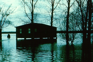
Evacuation of livestock in the Maugerville-Sheffield area, St. John River, NB (April 30, 1973)

Activities of Public Safety Canada
In addition to administering flood disaster assistance payments, Public Safety Canada undertakes other activities that indirectly reduce flood damages. Their college offers a number of courses aimed primarily at municipal officials, both elected and non-elected. The courses are designed to point out their responsibilities for the development and implementation of plans to meet emergencies.
Flooding is one of 60 emergencies for which the officials are trained. Introductory courses provide participants with a broad base from which they will be able to carry out planning and operations during an emergency or disaster. In the more advanced courses, disaster situations are simulated and students experience conditions where they have to make life-threatening decisions.
Furthermore, to promote good planning and national preparedness, Public Safety Canada administers the Joint Emergency Preparedness Program on behalf of the federal government. Roughly $4.5 million is spent annually by the federal government, to help provinces and territories with emergency preparedness projects. Projects can involve establishing emergency plans, setting up more effective communication systems, as well as acquiring rescue equipment which could potentially assist in reducing flood damages and loss of life. The provinces and territories spend about $5.5 million per year on these projects.
Alberta Public Safety Services Training School
In the field of disaster training, the Alberta Public Safety Services Training School (at Edmonton) is a valuable resource for anyone involved with disaster preparedness and response. Together with the Emergency Preparedness Canada College at Arnprior, the schools are the only specially designated facilities in Canada.
The Training School was developed in support of Alberta legislation requiring each municipality to develop an emergency response plan for disasters.
- Insight, December 1989
See also: Public Safety Canada and the Canadian Emergency Management College
Stormwater management
Urban drainage
The effects of urbanization on stormwater drainage are related to the change in the quality, runoff rate, and the volume of stormwater entering the natural drainage system. In an urban setting, no longer is the runoff delayed by minor topographic depressions, the vegetative cover, or the indirect routes natural surface runoff must follow. Instead, runoff rates are increased due to the large area of impervious surfaces directing runoff into sewer pipe systems and more efficient drainage channels. These pipes and channels are capable of conveying the runoff to the receiving streams more rapidly than under pre-development conditions.
The impervious surfaces also reduce the area available for rainfall infiltration. The subsequent reduction of water infiltrating the soil may result in a lowering of the water table and a potential reduction in the amount of groundwater recharging streams during normally low flow periods.
This is a typical hydrograph of an urban stream during a rainstorm. It illustrates that the peak flows of urbanized streams respond more quickly and are much higher than the pre-development situation. The recession of the streamflow following a storm is also more rapid. This increase in discharge also causes erosion of the stream banks due to higher flow velocities.

Source: Adapted from Drainage Manual, Roads and Transportation Association of Canada, 1982.
Details can be found below
The graph shows that urbanization increases peak flows and surface runoff volumes over pre-urban levels.
In association with the altered drainage characteristics there are changes in water quality. The runoff from the urban area contributes pollution loading of nutrients, bacteria, sediment, heavy metals, oils, grease and, in the spring, road salt.
The "first flush" is a phenomenon whereby the initial stormwater runoff picks up pollutants from catchment surfaces, such as roads and parking lots, and sewer deposits, where they have been collecting since the last storm. Once these pollutants are washed through the system, the pollution level of the stormwater decreases for the remainder of the storm.
In older Canadian communities, stormwater and sanitary wastewater are carried by a combined system to a treatment plant before being released to the receiving water body. During a heavy rainfall the capacities of the pipes and the treatment plant are often exceeded. This results in the flow backing up through the system, causing road and basement flooding with combined stormwater and sanitary wastewater. Meanwhile, much of the water in the pipes bypasses the treatment plant, to be released directly into the receiving water.
Newer communities employ separate pipes to carry the sanitary wastewater and stormwater. The sanitary wastewater pipes are connected to the sewage treatment plant, whereas the stormwater pipes drain directly to the receiving streams. During a major storm, the stormwater system may still back up, causing flooding of roads and basements. Generally, the stormwater is less polluted than the combined sewer flow. Some communities use settling ponds to provide primary treatment of stormwater.
Application of stormwater management
Stormwater management has evolved in the past several years to a point where it is recognized that comprehensive planning with multi-agency involvement is necessary to ensure the protection of human life, property, and our natural receiving waters. The three key components which are developed in this planning process include the Watershed Management Plan, Sub-watershed Plan, and Stormwater Management Plan. To ensure effective stormwater management, all three components should be completed and be directly related to the municipal planning process.
Watershed Management Plans are comprehensive strategies that establish broad water management goals and targets for an entire catchment. First, the plan documents and examines the physical, chemical and biological characteristics of the basin. This information is then used to define the existing and potential water uses. General goals, objectives, control methods and/or technologies are then evaluated and selected on a basin basis to protect or enhance the receiving waters.
Official Plans set out the objectives and policies which municipalities use to guide development. These plans should contain the stormwater management goals and targets established in the Watershed Management Plan. The municipality should make a commitment for comprehensive planning at all stages of land use planning.
Sub-watershed Plans address the requirements for stormwater management on a sub-basin level. They use information prescribed in the Watershed Management Plan to develop necessary sub-watershed stormwater controls such as infiltration, trenches, extended swales (low-lying land) or stormwater ponds. This planning level is at the same scale as the neighbourhood (secondary) plans, which provide more specific planning details such as land use and transportation corridors. Developing these two plans in an integrated manner will ensure the optimization of all resources within that sub-basin.
Similarly, Stormwater Management Plans and the Plan of Subdivision should be developed jointly. Stormwater management should be considered at an early stage in the subdivision planning process because it may significantly affect such items as the layout of subdivision lots, roadways and other services.
Another stormwater management concept involves minor and major drainage systems. The minor system is considered as the "convenience" drainage system that carries storm flows during frequent rainfall events. The major system consists of the streets, swales and open channels that carry water during high but infrequent floods.
Minor drainage systems consist of the subsurface pipes that carry stormwater in either combined or separate pipes. Although the minor system is perceived by most to be the primary means of disposing of stormwater, as stated, it carries a small proportion of the total rainfall during an extreme storm. These systems are only designed to carry stormwater from a two- to ten-year storm. If the pipes were built to carry less frequent but larger storm flows, their diameter would be immense and they would be very costly to install.
The purpose of a major drainage system is to transport the excess overland stormwater flow in a controlled manner. Uncontrolled overland flows erode properties, flood basements, damage foundations through the buildup of hydraulic pressures, and flood roads.
Major drainage systems are now typically designed to handle the 100 year storm. They also provide the most cost effective method of expanding the drainage capacity of an area.
Detention of stormwater runoff serves as short-term storage of stormwater until it is slowly released under controlled conditions. Storage facilities include methods such as retention (wet), detention (dry) and infiltration ponds, flat roofs of commercial buildings, large parking lots, local and arterial streets, and subterranean tanks or silos.
Ponds are also an effective way to manage stormwater due to their large holding capacity. There are generally two types of ponds, namely "dry" and "wet." Dry ponds are typically dry; they hold water for a limited time only, releasing it to a receiving water slowly through a controlled outlet. Wet ponds are permanent water bodies designed to hold water until their capacity is exceeded, thus overflowing to a receiving water. They are long-term storage facilities and therefore provide long retention times. Wet ponds also serve as groundwater recharge sites.
The purpose of rooftop, parking lot, street and subterranean storage is to delay the runoff or reduce the discharge rate to the major and minor systems. The basic requirements for the use of this technique include a containment location and an outflow release device to control the rate of runoff. Where necessary, an emergency overflow device should be included.
There are other methods of altering urban drainage. Groundwater recharge can be achieved through the use of porous pavement in roads and parking lots. In residential areas, well-designed landscaping techniques and construction materials can make the major drainage system effective yet unobtrusive.
Structural measures
Dams
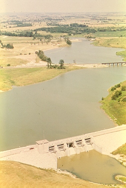
Flood water storage may be in small inexpensive farm ponds or it may be in huge reservoirs costing millions of dollars; the principle is the same. During the period of high flow, excess water is stored above the protected area in a reservoir until such time as water levels in the downstream reaches of the river have dropped to the point where water may be safely released.
In addition to being effective for its primary purpose, this method of flood control can have other benefits. Stored water can later be used to augment river flows downstream for such purposes as recreation, navigation and hydroelectric power generation.
Dykes
Dykes are embankments built to protect low-lying areas from inundation and are the most commonly used structures to protect Canadian communities. They alter only high flows of water by restraining entry to the low-lying areas. The degree of protection provided by dykes depends on their height and construction. High water occurrence increases pressure against the dykes, accelerates their erosion, hastens their saturation and damage due to under-seepage, and may result in overtopping during extreme floods. Any of these incidents can result in dyke failure. The reliability a dyke system offers is contingent upon its continued inspection and maintenance. Dyke construction frequently necessitates the installation of internal drainage and pumping facilities to minimize flooding behind the dyke caused by seepage through the dyke, the interruption of the natural drainage within the protected area, and by the backing up of sewers during high stormwater runoff.
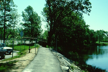
Brewer Park dyke - Ottawa, Ontario
Channel improvements
Channel improvements include realignment to eliminate oxbows and sharp bends, dredging, removal of debris, installation of weirs or drop structures, and provision of bank protection.
Each of these measures contributes to one or more of the following:
- the stabilization of the river course;
- increases in gradient and flow velocity;
- an enlargement of channel capacity; and
- the reduction of bank or channel erosion.
Increased gradient, flow and capacity assist in lowering river levels upstream, while stabilization of banks and channels facilitates the river's passage.
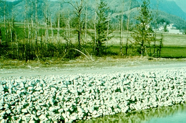
Bank stabilization - Fraser River
Flow regulation
Diversions
Reduction or elimination of the inundation hazard often is accomplished through control or regulation of river flow by storage or diversion of water upstream from the flood-prone area. A diversion involves the redirection of part or all of a river's flow either around a particular location in a basin or out of the basin entirely. It offers a reliable and positive degree of flood control through reduction in flow downstream. The development of a diversion may require the construction of a dam, particularly if the diversion is out of the basin, or the installation of inlet and outlet control structures may be sufficient. Excavation of a diversion channel or the improvement of an existing channel is usually necessary.
Storage
Rivers contain some natural storage capacity in their lakes, swamps and marshes, which can reduce flood peaks to some extent. However, this reduction rarely, if ever, is sufficient to prevent downstream inundations under all circumstances. Artificially created and controlled storage can be directed specifically toward this purpose. This can be achieved through retention basins and storage reservoirs, and through alteration of existing lakes. Retention basins are usually located adjacent to a river; water is diverted into them and later released back to the river. Storage reservoirs, which require dams, tend to have greater storage capacity than retention basins and are located upstream from the areas of inundation. A lake's storage capacity is usually increased by constructing a dam and spillway at the natural outlet.
Reservoir water levels are usually lowest just prior to the spring snowmelt runoff. The upstream runoff is stored and later released back to the river system, to augment the natural summer and winter low flow period.
Ice booms
Ice booms are prevalent in eastern Canada. The booms are similar to log booms but are placed across a river to prevent the downstream movement of ice. They are installed in the fall and removed after the spring ice breakup period. A major ice boom is placed across the head of the Niagara River each year to prevent the input of Lake Erie ice to the already considerable production of ice in the gorge below Niagara Falls.
In 1965, ice booms were used for the first time to protect the St. Lawrence River shipping channel from ice floes. Several booms are located in Lac Saint-Pierre, and at Lavaltrie and Île Saint-Ours. The booms are designed and located to form a stable ice cover outside the shipping lanes as early as possible. They also serve to protect the ice cover from breakup due to wind and wave action, thus preventing floes from entering the channel to become a danger to shipping or to cause jams.
See also: Case studies: Flood Control on the Red, Assiniboine and Fraser Rivers
Floodproofing
Floodproofing is a means of protecting individual structures in the flood fringe from damage. Basic techniques include:
- raising the foundation above the flood level using fill or supports;
- sealing all openings below the floodline, either temporarily or permanently;
- surrounding the building with floodproof masonry or concrete walls or berms (low embankments of earthen fill with moderate side slopes and a wide top);
- allowing the basement to flood but keeping the habitable portion of the structure above the floodline;
- using one-way valves in the sewer system to prevent backflush from the sewer lines; and
- placing telephone and electrical transformers and mechanical systems above the floodline.
A common practice for new construction is to raise the building above the design flood elevation, by either elevating the landscape or raising the building. Under most circumstances, it is not practical to raise existing buildings.
Floodproofed structure - Richelieu River
By using fill, individual homes or whole subdivisions can be raised above the design flood level. The buildings do not require any special design modifications. However, if a sufficient volume of fill is put into the floodplain, it may reduce the carrying capacity of the floodplain, causing the flood levels to rise even higher.
The use of piers, piles, columns or bearing walls to elevate the structure represents an efficient use of land, does not raise the flood level, and has minimal adverse effect on flood flows. However, this method requires careful design to prevent damage to the supports from floating debris.
Techniques to create watertight structures are applied to both new and existing buildings. For a building to be waterproofed, it is necessary that the foundation walls be strong enough to withstand the lateral and uplift pressures of the water without cracking. The basement doors, windows and drainage systems must also be adequately watertight. Doors and windows can be permanently sealed or covered when a flood warning is issued. Sewer drains are installed with a one-way valve to prevent the sewer line water backing up into the basement. For floods of long duration the watertightness method is not suitable. If the system does fail or the design flood is exceeded, damage to the building's interior and contents could be severe.
The construction of floodproof walls and berms is intended to keep a structure dry without any modifications to the building. Many people prefer this method of floodproofing because it requires no change to the building. Although effective, floodwalls and berms may not be practical for individual buildings in dense urban areas, as they require a considerable amount of land. Adequate flood warnings are also required to allow any openings to be sealed. If the system is breached, there could be serious flood damage to the building and contents.
The previous methods are generally referred to as "dry" floodproofing because water is prevented from entering the building. The concept of "wet" floodproofing accepts that water will enter the building. In some cases, particularly in sandy soils, water pressure on the foundation walls and floor can be so severe that buildings can be heaved out of the ground, or off their foundations, by the force of the floodwaters. Therefore, wet floodproofing (the deliberate flooding of a structure to balance the water pressure on the interior and exterior walls and floors) may be necessary. This method of floodproofing is most often used as a last resort to prevent building collapse because of the time and cost of cleaning up and drying out after the flood. It should not be undertaken without professional advice.

Source: Adapted from Design Manual for Retrofitting Flood-Prone Residential Structures, Federal Emergency Management Agency (FEMA), 1986.
Details can be found below
Basic approaches to floodproofing. The illustration shows the basic approaches to floodproofing, from the simplest to the most major as follows: wet floodproofing, dry floodproofing, floodwalls, elevation, and relocation.
Emergency floodproofing measures
Emergency floodproofing measures are set in motion on short notice. The techniques commonly used entail building dykes or barriers using whatever natural or stored materials may be on hand at the site. Although generally inexpensive, hard work is involved. A pre-determined plan of action is essential to ensure materials, labour and equipment are available at the time of flooding.
Emergency floodproofing measures should never be used as a substitute for permanent floodproofing measures. This is especially true in areas prone to ice jam flooding or where flash flooding occurs frequently.
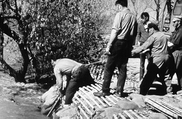
Sandbag dykes
The most common emergency floodproofing technique entails stacking sandbags in such a way as to form a barrier against rising floodwaters. The bags must be strong enough to hold the sand or fill and withstand contact with water indefinitely. It is best to use burlap and plastic bags designed for that purpose and to use a durable plastic sheet to prevent the seepage of water through the dyke.
Since water exerts pressures against the sandbag dyke, if at all possible a trench should be dug to prevent the dyke from moving. Other methods of anchoring the dyke include placing the bottom of the dyke against or on permanent features, e.g., a ditch, a raised roadbed, a foundation wall etc.
The bags should not be totally filled with sand. This allows one to overlap the other and serves to lock the bags together. In addition, the bags should be placed so that each layer is put at right angles to the layers above and below, adding stability to the structure.

Source: Adapted from Floodproofing: Protect Your Home against Flooding. Environment Canada and New Brunswick Department of Municipal Affairs and Environment, 1989.
Details can be found below
Floodproofing - cross-section of a sandbag dyke. The illustration shows the construction of a sandbag dyke. A bonding trench narrower than the proposed dyke is dug and a plastic sheet is laid in the trench and on the ground on either side to the width of the dyke. Sandbags are piled to the expected flood level, with the plastic sheet covering the water side of the dyke to just above flood level. Another layer of sandbags is placed on top.
Floodproofing your home -- where to start
- Learn as much as you can about flooding in your community.
If your site is located in one of the areas mapped under the Flood Damage Reduction Program, you can receive detailed information on flood levels from Environment Canada offices.
If you are located in an unmapped area, good sources of flood information are available from the same federal government offices listed in the FDR Program section of the Web site, as well as provincial government agencies, your municipal government, and local libraries. The memories of long-term residents of the area can also be useful.
It is important to evaluate the flood hazard in your area properly. Factors to consider include the extent of flooding, the speed of floodwaters, the rate of rise in water levels, and the duration of flooding.
Definitely, the best protection is to avoid building in areas prone to flooding. - Learn more about floodproofing.
Information can be obtained from public and university libraries, or from agencies such as the Canada Mortgage and Housing Corporation. Local contractors, as well as engineering and architectural firms, can also provide useful information regarding water resistant materials and construction practices.
- Select an appropriate method of floodproofing.
There are several methods for floodproofing buildings. In selecting a method of floodproofing, consider the following:
- the characteristics of the flood hazard;
- the physical conditions at the site;
- the building's function, operation and use; and
- the type and condition of the building.
In areas prone to frequent or flash flooding, it is recommended that permanent floodproofing methods be undertaken. As these floodproofing measures are always in place, there is little chance of being unprepared when flooding occurs.
Always seek expert advice when required because improper floodproofing can cause serious structural damage to buildings. - Evaluate the costs and benefits of floodproofing.
Determine the cost of floodproofing your property and weigh it against the cost of future flood damages. You should also consider the personal danger and hardship you and your family may face if you do not floodproof.
- Plan your floodproofing project, and hire qualified people to do the work.
Know the extent of any remaining flood risk because you can never eliminate it entirely.
Source: Adapted from Floodproofing: Protect Your Home against Flooding. Environment Canada and New Brunswick Department of Municipal Affairs and Environment, 1989
Return to Floods menu
Previous page: Causes of Flooding, next page: Flooding Events in Canada