
Minister’s transition binder
Impact Assessment Agency of Canada Transition 2019
Table of Contents
- Agency Overview
- Overview of Environmental/Impact Assessment
- Current and Potential Environmental and Impact Assessments
- Annexes
List of Current and Potential Environmental and Impact Assessments
- 3. C – Anticipated Decisions in Next 100 Days
- 3. D – Other Assessments
- Laurentia Project: Port of Quebec Deep-Water Wharf - Beauport Sector
- James Bay Lithium Mine
- Rose Lithium - Tantalum Mining Project
- Beaver Dam
- Energie Saguenay
- Milton Logistics Hub
- WesPac
- Contrecoeur Port Terminal Expansion Project
- Roberts Bank Terminal 2
- Deep Geologic Repository for Low and Intermediate Level Radioactive Waste
- Central Ridge Exploration Drilling Project
- Project 6 All-season Road
- Springbank Off-Stream Reservoir Project
- Grassy Coal
- Lake St. Martin Water Diversion
- Sukunka Coal
- Kitimat LNG Expansion
- Fifteen Mile Stream
- Cochrane Hill
- Delta Grinding Facility Project
- BHP Canada Exploration Drilling Project
- Tilt Cove Exploration Drilling Project
- Mine Fire Lake North
- Bay du Nord
- West Flemish Pass Exploration Drilling Project
- Foxtrot Rare Earth Element Mine
- Trois-Rivières Port Facilities Expansion Project
- Boat Harbour Remediation
- Southeastern Newfoundland Offshore Exploration Drilling Project
- Lynn Lake Gold Project
- Lac Windfall Mine Project
- Hwy 905 Stony Rapids– Lake Athabasca (Fond-du-Lac)
- Bending Lake Iron Project
- Valentine Gold Project
- Ruddock Creek
- Timiskaming Dam-Bridge of Quebec Replacement Project
- Cape Ray Gold
- Michel Coal Project
- Crown Mountain
- St. Lawrence Fluorspar Marine Shipping Terminal Project
- Griffith Mine Project
- Kwispaa LNG
- Joyce Lake
- Springpole Gold Project
- More Creek Hydro Project
- Century Gold Project
- Mine Hopes Advance
- Kipawa Rare Earths Project
- Arctos Anthracite
- Aley
- Coal Mountain Project
- Bingay Main
- Kitimat Clean Refinery
- Marathon PGM
- Carbon Creek Coal Project
- Amisk Hydro
- Pacific Future Energy Refinery
- Assessments by other Responsible Authorities (RA)
- 2021 NGTL System Expansion Project
- Edson Mainline Expansion Project
- North Corridor Expansion Project
- Micro Modular Reactor Project at Chalk River
- Millennium Uranium Mine
- Rook I Project
- Wheeler River Project
- In Situ Decommissioning of the Whiteshell Reactor
- Near Surface Disposal Facility
- Nuclear Power Demonstration Closure
- 3. E – Current Impact Assessments
- 3. F – Anticipated Project Submissions in the Next 90 Days
1. Agency Overview
I. Mission
The Agency is responsible for providing high-quality assessments (environmental or impact) and coordinating Crown Indigenous consultation related to the review of major projects.
II. Operating Context and Major Challenges and Pressures
The Impact Assessment Act (IAA) came into force on August 28, 2019, expanding the Agency’s mandate and responsibilities as the single Agency responsible for impact assessment and the Crown coordinator for Indigenous consultation of major projects. Under the IAA, the Agency is responsible for assessing the positive and negative environmental, economic, social, and health impacts of potential major projects.
The IAA repealed and replaced the Canadian Environmental Assessment Act, 2012 (CEAA 2012). It includes transitional provisions for assessments that began under previous legislation.
Under the IAA:
Impact assessments are carried out on designated projects. These projects can either be designated by the Physical Activities Regulations or they can be designated by the Minister of the Environment under s. 9.
The Information and Management of Time Limits Regulations enable the new impact assessment system to function and enhance clarity, transparency and predictability in the process.
During the Parliamentary review of the IAA, it was controversial and received a high profile in the press. While supported by the mining industry and many Indigenous communities and environmental groups, it was not supported by the oil and gas industry and several provinces.
The Agency is in the early stages of implementing the IAA, which has involved: the development of regulations; new policy and guidance; the negotiation of agreements with other jurisdictions; memoranda of understanding with federal authorities; development of a new public registry; and the hiring of new FTEs.
Currently, 63 projects are being reviewed pursuant to the IAA and its predecessor legislation. Of these 63 projects, 44 are ongoing environmental assessments by the Agency, six are ongoing active review panels, eight are approved and ongoing substitution projects, one is undergoing a Regional Assessment, and four projects are being reviewed under the IAA (planning phase). Over the next 90 days, the Agency expects to receive submissions for 12 new projects.
III. 2019-20 Budget and Full-Time Equivalents
For 2019-20, the Agency’s budget is $68.2M before the Employee Benefit Plan (EBP) and has 446 funded FTEs. The Agency has five regional offices (Vancouver, Edmonton, Toronto, Quebec City, Halifax) and a satellite office in St. John’s.
IV. Key Federal Partners and External Stakeholders
Federal Partners:
- Departments with environmental, social, health, and economic expertise;
- Life-cycle regulators:
- Canada Energy Regulator
- Canadian Nuclear Safety Commission
- Offshore Boards
External Stakeholders:
- Proponents of major projects
- Provinces and other jurisdictions with mandates related to impact assessment
- Indigenous peoples
- Industry associations
- Environmental groups and local communities
A. Senior Executive Biographies
I. David McGovern, President of the Impact Assessment Agency of Canada
 Contact Info:
David McGovern
Tel: (613) 948-2671
Email: david.mcgovern@canada.ca
David McGovern was appointed President of the Impact Assessment Agency of Canada on an interim basis, effective August 28, 2019.
Prior to this, David was Associate Deputy Minister at Innovation, Science and Economic Development Canada. He joined the department in May 2017.
Previously, David was the Deputy National Security Advisor to the Prime Minister from January 2015 until May 2017. He also served as Senior Advisor to the Privy Council Office, responsible for Border Action Plan Implementation and the Regulatory Cooperation Council starting in May 2014.
David was the Senior Assistant Deputy Minister of Strategic Policy and Research at the department of Employment and Social Development Canada from 2011. He was a participant in the 2012 cohort of the Government of Canada's Advanced Leadership Program.
From 2005 until 2011, David was the Assistant Deputy Minister of the International Affairs Branch at Environment Canada. From 2003 until 2005, he supported the Secretary of the Treasury Board Secretariat (TBS) on several key files and led a series of horizontal and vertical expenditure management reviews.
David also held executive positions in several other federal departments including the former department of Human Resources Development Canada (HRDC) and Transport Canada.
He is a graduate from McGill University and has a Masters of Science degree in Economics from the London School of Economics and Political Science.
II. Christine Loth-Bown, Vice-President of External Relations and Strategic Policy
 Contact Info:
Christine Loth-Bown
Tel: (613) 948-2662
Email: christine.loth-bown@canada.ca
Christine is the Vice-President of External Relations and Strategic Policy. She was appointed to this role in August 2018. Prior to this, she was the Vice-President, Policy Development, from April 2016 to August 2018. Reporting to the President, Christine is responsible for legislative, regulatory and policy elements of impact assessment. In addition, she is responsible for external relations and engagement.
Before joining the Agency, Christine was the Director General of Ecosystems Management at Fisheries and Oceans Canada (DFO).
Christine has over 24 years experience in policy development and program implementation. She has held senior roles at the Canadian Tourism Commission (CTC) and DFO. Christine has led the development and implementation of legislation and regulations. She has also played a leadership role in the development of a number of strategic policy initiatives, and corporate planning frameworks.
Christine holds a Master of Arts in Canadian Studies from Carleton University, Ottawa, and a Bachelor of Arts (Honours) in Canadian Studies and Political Science from Glendon College, York University, Toronto, Ontario.
III. Terry Hubbard, Vice-President of Operations
 Contact Info:
Terry Hubbard
Tel: (613) 948-2665
Email: terence.hubbard@canada.ca
Terry Hubbard is the Vice-President of the Operations Sector. He was appointed to this role on September 10, 2018. Prior to joining the Agency, Terry was Director General of the Petroleum Resources Branch with Natural Resources Canada. In this role, he was responsible for Canada’s oil and gas policy, including overseeing the development and implementation of Canada’s pipeline safety and offshore oil and gas regulatory regimes.
Terry worked as the government lead on legislative proposals to modernize the National Energy Board (NEB). He has significant background and experience on environmental assessment and regulatory matters having had the responsibility of policy oversight for the NEB and for the Canada-Newfoundland and Canada-Nova Scotia Offshore Petroleum Boards.
Terry graduated from the University of Saskatchewan where he obtained both his Bachelor and Master of Arts degrees in economics.
IV. Alan Kerr, Vice-President of Corporate Services and Chief Financial Officer
 Contact Info:
Alan Kerr
Tel: (613) 960-0897
Email: alan.kerr@canada.ca
Alan Kerr was appointed Vice-President of the Corporate Services Sector and Chief Financial Officer in 2016.
Prior to joining the Agency, Alan was General Manager responsible for ATCO’s operations and business activities in Europe and the Middle East, based in Budapest, Hungary.
Alan held a variety of senior leadership roles with the Royal Canadian Navy and in National Defence Headquarters. He is a Chartered Professional Accountant (CPA) and a Chartered Management Accountant (CMA) and holds a Bachelor of Arts degree in Commerce and a Master of Science degree in National Resource Strategy.
In 2003, Alan was recognized for his exceptional service and appointed Officer of the Order of Military Merit by the Governor General of Canada.
B. Impact Assessment Agency of Canada Executive Organizational Structure
- David McGovern – President
- Jean-Sebastien Rochon - A/Director and Legal Counsel
- Terry Hubbard – Vice-President – Operations
- Lisa Walls – Director General – Operations Transition and Readiness
- Kurt Saunders – Director – Review Panels
- Ian Ketcheson – Director General – Crown Consultation
- Colette Spagnuolo – Director – Crown Consultation
- Steve Chapman – Chief Science and Knowledge Officer
- Jennifer Saxe – Director General – Regional Operations
- Regina Wright – Regional Director – Pacific and Yukon
- Barbara Pullishy – Regional Director – Prairies and Northern
- Anjala Puvananathan – Regional Director – Ontario
- Anne-Marie Gaudet – Regional Director – Quebec
- Mike Atkinson – Regional Director Atlantic
- Alan Kerr – Vice-President – Corporate Services and CFO
- Christopher Walters – Director – Communications
- Jean-Paul Lalonde – Director – IM/IT
- Claren Motokado – Director – Finance and Administration and DCFO
- Sylvain Campeau – Director – HR and Employee Wellness
- Stewart Lindale – Acting Chief Innovation and Evolution Officer
- Sharonne Katz – Director – Planning, Results and Executives Services
- Christine Loth-Bown – Vice-President – External Relations and Strategic Policy
- Eric Advokaat – Director General – External Relations and Engagement
- Erin Groulx – Director – Engagement
- Brent Parker – Director General – Strategic Policy
- Miriam Padolsky – Director – Science Policy
- Susan Winger – Director – Indigenous Policy
- Vacant – Director General – Intergovernmental Affairs and Legislative and Regulatory Affairs
- Tara Frezza – Director – Intergovernmental Relations
- Stephanie Lane – Director- Legislative and Regulatory Affairs
- Eric Advokaat – Director General – External Relations and Engagement
C. Office Locations
22nd Floor, Place Bell
160 Elgin Street
Ottawa ON K1A 0H3
Tel.: 613-957-0700
Fax: 613-957-0862
200-1801 Hollis Street
Halifax, NS B3J 3N4
Tel.: 902-426-0564
Fax: 902-426-6550
Canada Place
1145-9700 Jasper Avenue
Edmonton, AB T5J 4C3
Tel.: 780-495-2037
Fax: 780-495-2876
901-1550, d'Estimauville Avenue
Quebec, QC G1J 0C1
Tel.: 418-649-6444
Fax: 418-649-6443
410-701 West Georgia Street
Vancouver, BC V7Y 1C6
Tel.: 604-666-2431
Fax: 604-666-6990
600-55 York Street
Toronto, ON M5J 1R7
Tel.: 416-952-1576
Fax: 416-952-1573
301-10 Barters Hill
St. John’s, NL A1C 6M1
Tel.: 709-597-2362
Fax: N/A
2. Overview of Environmental/Impact Assessment
A. Background
An assessment (environmental or impact) is a planning tool to assist project design and ensure that appropriate measures are in place to mitigate impacts. It also serves to build social acceptability through a staged consultation process and to allow decision-makers to consider whether projects are in the public interest, or whether their impacts are justified in view of the benefits they will have for Canadians.
Federal impact/environmental assessment legislation establishes the legislative basis to assess and make decisions on proposed projects that involve impacts in areas of federal jurisdiction.
Environmental assessment was first introduced in Canada in 1974, when the Federal Environmental Assessment Office was established within the Department of Environment. In 1995, the Canadian Environmental Assessment Act came into force and established the Canadian Environmental Assessment Agency as a separate body from Environment Canada.
Over the years, the environmental assessment process has evolved greatly through intergovernmental agreements to harmonize the provincial and federal processes, amendments to the Act that expanded the role of the Agency, (including the coordination of Crown consultation), and Supreme Court decisions that clarified and broadened the scope of assessments.
In 2012, the Canadian Environmental Assessment Act, 2012 (CEAA 2012) came into force and brought on a number of other changes, further expanding the role of the Agency, as well as giving the Minister of the Environment the authority to impose enforceable conditions on proponents.
In 2016, the Minister of Environment and Climate Change was mandated to review federal impact assessment processes and to develop a new impact assessment regime based on best practices and stakeholder input.
On August 28, 2019, the Impact Assessment Act (IAA) came into force and replaced CEAA 2012.
B. Impact Assessment Process Overview
Impact Assessment Process Overview
C. Regulations
I. Physical Activities Regulations (Project List)
- Describes designated projects that may be subject to an impact assessment
- Focuses federal impact assessments on projects that have the most potential for adverse environmental effects in areas of federal jurisdiction
II. Information and Management of Time Limits Regulations
- Sets out the information that the proponent must provide during the planning phase
- Sets out the documents that the Agency must provide to guide the impact assessment
- Provides the circumstances under which the Agency may suspend the legislated timelines
The above regulations were published in Canada Gazette, Part II on August 21 and came into force on August 28, 2019, with the Impact Assessment Act.
III. Cost Recovery Regulations
The Cost Recovery Regulations established under the Canadian Environmental Assessment Act, 2012 (CEAA 2012) continue to apply under the Impact Assessment Act until new cost recovery regulations are developed. The Cost Recovery Regulations currently provide for the recovery of costs incurred to support and conduct a review panel assessment, from the time an assessment is referred to a review panel until the decision statement is issued.
D. Role of the Minister
Under the Impact Assessment Act (IAA), some of the Minister of the Environment’s authorities include:
- Referring impact assessments to a review panel
- Approving the substitution of a federal impact assessment with the process of another jurisdiction
- Providing early notice to the proponent of potential unacceptable environmental effects
- Extending time limits for impact assessments and decision making
- Decision making after an assessment by the Agency or after a substituted assessment, including setting enforceable conditions to be implemented by the Proponent
- Making regulations
- Making Orders
- Making policies and entering into agreements relating to impact assessment decisions to undertake a regional or strategic assessment
- Establishing the Minister’s Advisory Council
I. Referring impact assessments to a review panel
- The Minister may refer the impact assessment of a designated project to an independent review panel, if the Minister is of the opinion that it is in the public interest to do so.
- The Minister sets the review panel’s terms of reference.
- The Minister may enter into an agreement with another jurisdiction to establish a joint review panel.
- The Minister must refer an impact assessment to a review panel if the project is regulated under the Nuclear Safety and Control Act or the Canadian Energy Regulator Act.
- In these cases, the panel’s terms of reference are established by the Minister in consultation with the President of the Canadian Nuclear Safety Commission or the Lead Commissioner of the Canada Energy Regulator.
- The Minister may terminate an assessment by review panel if the panel does not, or is not likely to, meet its deadline. In these cases, assessment is completed by the Agency.
- The Minister may seek clarification from a review panel with respect to its conclusions and recommendations.
II. Approving the substitution of a federal impact assessment with the process of another jurisdiction
- The Minister may approve the substitution of a federal impact assessment with the process of another jurisdiction, on request of the jurisdiction, if the Minister is of the opinion that it would be an appropriate substitute.
III. Providing early notice to the proponent of potential unacceptable environmental effects
- Before the end of the planning phase, the Minister must provide a notice to a proponent if:
- The Minister is of the opinion that the project is likely to have unacceptable environmental impacts in areas of federal jurisdiction, or
- If a federal authority has advised the Minister that it will not exercise a power (e.g. issuing a permit or authorization) necessary for the project to proceed.
IV. Extending time limits for impact assessments and decision making
- The Minister may extend timelines for a maximum period of up to 90 days:
- the impact assessment phase to permit cooperation with another jurisdiction or to take into account circumstances specific to a project,
- the decision making phase for any reason.
- The Minister may recommend to the Governor in Council further extensions.
V. Decision making after an assessment by the Agency or after a substituted assessment, including setting enforceable conditions to be implemented by the proponent
- The Minister has decision making responsibility after an impact assessment by the Agency or after a substituted assessment.
- The decision determines whether the adverse effects within federal jurisdiction and the adverse effects that would result from a federal decision about the designated project are in the public interest.
- The Minister may refer the decision to the Governor in Council.
- The Minister must issue a decision statement to the proponent informing them of the determination made by the Minister or by the Governor in Council, including reasons.
- The decision statement must be posted on the Canadian Impact Assessment Registry.
- The Minister must also establish conditions, included in the decision statement, that he or she considers appropriate, in relation to the adverse effects of the project within federal jurisdiction, with which the proponent must comply.
VI. Making Regulations
- The Minister has the authority to make regulations on a variety of subject matters, including:
- with respect to information requirements and the management of time limits (note the Information and Management of Time Limits Regulations were made on coming into force of the IAA),
- with respect to the participant funding program, and
- with respect to the procedures and requirements related to regional and strategic assessments.
- In addition, for certain project types identified on the Physical Activities Regulations (offshore exploratory wells and offshore wind projects), a Ministerial regulation can be used to exclude those project types from being designated projects based on the results of a regional assessment and where the project meets the conditions set out in the regulation.
VII. Making Orders
- The Minister may designate a project not on the Project List to enter the planning phase Footnote 1, if the Minister is of the opinion that the carrying out of the project may cause adverse effects within federal jurisdiction or adverse effects resulting from federal decision, or public concerns related to those effects warrant the designation.
- The Minister may exclude a designated project from application of the IAA, if it is being carried out in response to an emergency.
- With respect to projects on federal lands or lands outside of Canada, the Minister may:
- Designate activities that may cause significant adverse environmental effects but which are not covered by the definition of “project” (i.e. inclusion list). Authorities seeking to carry out such an activity would be required to make a determination of whether the project is likely to have significant adverse environmental effects.
- Designate projects that will cause only insignificant adverse environmental effects (i.e. exclusion list). Authorities would not be subject to the requirements under the IAA with respect to these projects.
VIII. Making policies and entering into agreements relating to impact assessment Decisions to undertake a regional or strategic assessment
The Minister has a variety of additional powers to support the implementation of the IAA, including the authority to:
- Issue guidelines and codes of practice respecting the application of the IAA.
- Establish research and advisory bodies in the area of impact assessment, including with respect to the interests and concerns of Indigenous peoples, and appoint members of such bodies (the Technical Advisory Committee and the Indigenous Advisory Committee have been established).
- Establish criteria for the appointment of review panels, and members of committees for strategic and regional assessments.
- Enter into agreements or arrangements with any jurisdiction respecting impact assessments.
- If authorized by regulations made by the Governor in Council, enter into agreements with an Indigenous governing body with respect to powers, duties or functions that the Indigenous governing body may exercise in relation to impact assessments.
- With the Minister of Foreign Affairs, enter into agreements or arrangements with jurisdictions outside Canada with respect to impact assessment, including for the purposes of implementing the provisions of any international agreement
IX. Establishing the Minister’s Advisory Council
- The Minister must establish an advisory council to advise him or her on issues related to the implementation of the impact assessment and regional and strategic assessment regimes set out under the IAA.
E. Role of the Governor in Council
Under the Impact Assessment Act (IAA), the Governor in Council Footnote 2 has four key areas of responsibility:
- Making regulations or orders in relation to the impact assessment process
- Appointing the Agency President
- Approving extensions to assessment time limits beyond 90 days
- Decision making after an assessment by a review panel or if the decision is referred by the Minister of the Environment to the Governor in Council
I. Making regulations or orders in relation to the impact assessment process
Regulations
The Governor in Council has authority to make regulations and orders that are necessary for the impact assessment process to function or shape the process in certain circumstances.
This includes the authority to:
- Establish the Project List (Physical Activities Regulations) that identifies “designated projects” that are subject to the IAA.
- Identify certain federal bodies or organizations as “federal authorities” (e.g., Canada Port Authorities) or other bodies “authorities” (e.g. airport authorities) for the purposes of the IAA.
- Establish a cost recovery scheme.
- Enable the Minister to enter into agreements with “Indigenous governing bodies” that will authorize these bodies to exercise powers or perform duties in relation to impact assessments under the IAA on lands specified in the agreements.
- Vary the process on reserve lands and other Indigenous lands (e.g. covered by land claim agreements) or for reasons of national security.
- Issue an order excluding a designated project from application of the Act where there are matters of national security.
Orders
- The Governor in Council may identify lands subject to a land claims agreement where the IAA does not apply; and
- The Governor in Council may add a component of the environment or a health, social or economic matter to the definition of “effects within federal jurisdiction.”
II. Appointing the Agency President
- The President of the Impact Assessment Agency of Canada is appointed as a deputy of the Minister by the Governor in Council. There is also authority to appoint an Executive Vice-President.
- A person may not be acting President – in the event of an absence or incapacity – for more than 90 days without the Governor in Council’s approval.
III. Approving extensions to assessment time limits beyond 90 days
- Impact assessments and decision making are subject to legislated time limits. In addition to the Minister’s ability to extend assessment time limits by up to 90 days, the Governor in Council may make extensions beyond 90 days and may extend a time limit any number of times.
IV. Decision making after an assessment by a review panel or if the decision is referred by the Minister of the Environment to the Governor in Council
- The Governor in Council has decision making responsibility after an assessment by a review panel or when the decision has been referred by the Minister of the Environment. The decision determines whether the adverse effects within federal jurisdiction and the adverse effects that would result from a federal decision about the designated project are in the public interest.
- If a federal authority determines that the project is likely to cause significant adverse environmental effects, the Governor in Council may also be called on to make a decision on non-designated projects on federal lands or outside Canada (e.g. international development project). In these cases, the project may only proceed if the Governor in Council determines that those significant effects are justified in the circumstances.
- This same decision making scheme – Governor in Council determines whether significant adverse environmental effects are justified in the circumstances – applies to designated projects where the assessment is being completed under the Canadian Environmental Assessment Act, 2012 in accordance with the transitional provisions of the IAA.
F. Role of the President
Under the Impact Assessment Act (IAA), the President has the following responsibilities:
- Chief Executive Officer of the Agency, Accounting Officer under the Financial Administration Act and a deputy of the Minister of the Environment
- Federal Administrator under the James Bay and Northern Quebec Agreement
- Advising and supporting the Minister on decisions under the IAA and the Canadian Environmental Assessment Act, 2012, including whether to designate a project, approve substitution by a provincial review, refer a project to review panel, determine whether the adverse effects of a project are in the public interest and on the conditions to be included in a decision statement
- Appointing enforcement officers who verify and ensure compliance with the IAA
- Decision making under the Participant Funding Program
- Approving the membership and composition of, supporting the work of, and receiving information and advice from, both the Indigenous Advisory Committee and the Technical Advisory Committee on Science and Knowledge
The Minister may authorize the President to exercise any of their powers under the IAA.
G. Advisory Bodies
I. Minister’s Advisory Council
The Impact Assessment Act (IAA) requires the Minister to establish a Minister’s Advisory Council. Once established, the Council will advise the Minister on issues related to the implementation of impact assessment and regional and strategic assessment regimes.
II. Indigenous Advisory Committee
The IAA requires the Agency to establish an Indigenous Advisory Committee. The Committee was recently established and serves as a new structure through which First Nations, Métis and Inuit peoples provide advice to the Agency for the development of key policies and guidance to help ensure the unique rights, interests and perspectives of Indigenous peoples are acknowledged, affirmed and implemented in impact assessment.
The 11-member Indigenous Advisory Committee comprises experts who work in their personal capacity and hold 2- and 3-year terms. The Committee had its first meeting in July 2019, with a subsequent teleconference in September and its second face-to-face meeting November 6-7.
III. Technical Advisory Committee
The IAA requires the Agency to establish a Technical Advisory Committee on Science and Knowledge. Its mandate is to provide advice to the Agency on issues related to impact assessments, as well as regional and strategic assessments, including on scientific, environmental, health, social and economic issues.
The 13-member Committee comprises technical experts holding 2- and 3-year terms. The Committee had its first meeting in June 2019, with a second meeting in September and two others planned in fiscal year 2019-20.
H. Strategic and Regional Assessments
Regional and strategic assessments are tools made available through the Impact Assessment Act (IAA) to help address broader issues that can be challenging to address effectively in project impact assessments.
Regional and strategic assessments under the IAA support the Government of Canada’s strategy for addressing cumulative effects, and build from the previous Canadian Environmental Assessment Act, 2012, which allowed the Minister of the Environment to appoint a committee to conduct a regional study.
A key distinction between regional and strategic assessments is that regional assessments would focus on issues specific to a defined geographic region, while a strategic assessment could apply at a national scale and would focus on Government of Canada policies, plans, programs or issues relevant to impact assessment.
I. Strategic and Regional Assessments under the Impact Assessment Act
The IAA sets out requirements for conducting regional and strategic assessments, including:
- The Minister of Environment and Climate Change may establish a committee or authorize the Agency to conduct a regional or strategic assessment.
- The Minister may enter into agreements with other jurisdictions for regional assessments that include non-federal lands.
The IAA mandates the Minister’s Advisory Council to provide advice on regional and strategic assessments to be given priority.
The Minister may establish regulations exempting offshore oil and gas or offshore windfarm projects from requiring an impact assessment on the basis of a completed regional assessment.
The Agency is developing policies to guide the conduct of regional and strategic assessments. The policies will set out considerations for selecting regional and strategic assessments.
Any Canadian can request that the Minister conduct a regional or strategic assessment. The Minister must respond within 90 days with reasons.
II. Regional and Strategic Assessment Status
The first regional assessment is being conducted on offshore oil and gas exploratory drilling east of Newfoundland and Labrador. An agreement to conduct the regional assessment was announced on April 15, 2019, by the governments of Canada and Newfoundland and Labrador. The committee conducting the assessment must provide its report to the Minister by fall 2019, as required by its terms of reference.
Environment and Climate Change Canada has led the development of a draft Strategic Assessment of Climate Change. The draft assessment was posted for public comment in the summer of 2019 and feedback received is being compiled.
I. Engagement, Partnership and Collaboration
I. National Outreach and Engagement Program
A key Agency role has been to create awareness of Environmental Assessment (EA) in Canada, its objectives and processes, and to inform interested stakeholder groups about how to participate in EAs.
Under the Impact Assessment Act, the Agency expects that stakeholders will continue to participate in multidisciplinary planning and decision making processes and engage at various stages of proposed project reviews. However, while the Agency engages on specific issues or assessments, it must also build dependable, trusting and transparent relationships outside of individual projects.
The National Outreach and Engagement Program (NOEP) is currently being implemented to fulfil the Agency’s commitment to listen to and learn from Canadians and Indigenous peoples in order to continually adjust and improve its processes, policies and programs.
The NOEP is an integrated, structured and strategic program that brings together the planning of current and upcoming nation-wide activities to help cultivate existing relationships between stakeholders and the Agency and build new ones.
The NOEP brings under one umbrella the planning and tracking of activities under six streams of outreach and engagement: a new national proactive component to the Agency’s outreach efforts, the ongoing topic-driven engagement activities, Indigenous engagement, intergovernmental and international activities, targeted training, and responsive or reactive activities, as appropriate.
The Agency is developing a list of outreach events that senior management and staff will attend on an annual basis, along with the products that will help them deliver the Agency’s messages. Memoranda of understanding are being developed to solidify relationships and ensure open, clear and predictable communications on policy issues with national stakeholders.
In addition to this, the Agency continues to meet with Indigenous groups and communities across the country to build trust and discuss opportunities for the co-development of products and processes.
Finally, the Agency keeps in close contact with all its project-specific stakeholders and interested parties through regular phone calls, teleconferences, project meetings, webinars, etc.
II. Public Participation
The Impact Assessment Act (IAA) recognizes the importance of meaningful public participation and requires that opportunities are provided through the assessment process, in accordance with legislation, regulations, policies and guidance established by the Agency.
The Agency is committed to implementing a public participation approach for impact assessments of designated projects and regional and strategic assessments that is inclusive and responsive to community needs. To achieve these objectives, the Agency’s approach to public participation is guided by several overarching principles:
- It starts early and continues throughout each step of the process, including timely notification of proposed engagement.
- It is supported with funding made available through the Agency’s Participant Funding Program, which will be enhanced to improve public and Indigenous participation in impact assessments.
- It is transparent and information is available and accessible to the public on the proposed Impact Assessment Registry of Canada, unless subject to valid exceptions set out in the IAA, such as financial information that is consistently treated in a confidential manner.
- It is designed to increase the knowledge of participants and government and foster relationships. Citizens and communities are able to contribute to the science and evidence base for decision-making.
- It is designed to prioritize the participation of those who are most affected by the proposed project, while also ensuring that interested members of the public have an opportunity to share their views.
- Methods are flexible, innovative and consider the assessment context and legislated timelines. It includes a variety of engagement techniques that are appropriate to the circumstances and are accessible to diverse groups, including women, men, gender-diverse people and underrepresented Canadians.
- It influences decision making and participants see that their input was considered.
- It continually adapts and improves. Each assessment will contribute to a greater understanding of participation practices.
III. Training
The Agency offers three levels of training to:
- Agency employees
- Staff from federal departments
- Stakeholders
- Indigenous Groups
- Public
Level 1: Basic information and general knowledge of the Impact Assessment Act and its regulations, as well as impact assessment processes and concepts
Level 2: Advanced knowledge and skills to work on impact assessment related matters
Level 3: Technical knowledge and skills on specific topics related to the conduct of impact assessments
IV. Funding Programs
The Agency administers four funding programs:
- Participant Funding Program (PFP): provides limited financial assistance to individuals, incorporated not-for-profit organizations and Indigenous groups to help prepare for and participate in key stages of environmental and impact assessments undertaken by the Agency or by review panels.
- Policy Dialogue Program: supports the provision of external advice and participation in the development of policies, methodologies, tools, and practices related to impact assessment, regional assessments, and strategic assessments. There are four streams: Collaboration, Workshops, Indigenous Engagement, and Advisory Committees.
- Indigenous Capacity Support Program: supports the development of local and regional Indigenous knowledge and capacity in order to effectively participate in, or undertake project impact assessments, regional and strategic assessments, policy engagement, impact assessment monitoring and follow-up activities, and IAA-related activities.
- Research Program: promotes and disseminates new and innovative research that furthers the practice of impact assessment, including regional/strategic assessments.
Funds provided under these programs are meant to support meaningful public participation and Indigenous consultation in a manner that contributes to the delivery of high-quality environmental/impact assessments and specific engagement activities.
All Funding Programs are administered in accordance with Terms and Conditions approved by Treasury Board. Eligible costs for grants and contributions may include travel expenses, professional fees (consultants or legal), reporting/research/data collection and analysis, honoraria for Elders and ceremonial offerings, and other reasonable administrative and reporting costs.
Two types of funding recipients:
- Indigenous Funding (IF): to assist in Indigenous participation and consultations (potential impacts on Aboriginal rights and titles) that occur during engagement activities conducted by the Agency or review panels.
- Regular Funding (RF): to assist in preparation for, and participation in, participation and engagement activities conducted by the Agency or review panels.
Eligibility Criteria: Applicants must demonstrate intent to provide value-added information and must meet at least one of the following criteria:
- have a direct local interest in the project or regional/strategic assessment, such as living or owning property in the project area;
- possess community knowledge or Indigenous knowledge relevant to the impact assessment or regional/strategic assessment;
- possess expert information relevant to the anticipated impacts of the project; and/or
- possess an interest in a project’s potential impacts on Treaty lands, settlement lands or traditional territories or related claims and rights.
Eligible Activities may include:
Impact assessment by the Agency:
- Initial Project Description (made available to IF only);
- Draft Tailored Impact Statement Guidelines, draft Public Participation Plan, or draft Indigenous Engagement and Participation Plan;
- Proponent’s Impact Statement; and
- Draft IA Report and Potential Conditions.
Impact assessment by Review Panel:
- Initial Project Description (made available to IF only);
- Draft Tailored Impact Statement Guidelines, draft Public Participation Plan or draft Indigenous Engagement and Participation Plan;
- Draft Review Panel Terms of Reference and, if applicable, the Joint Review Panel Agreement;
- Proponent’s Impact Statement;
- Preparation for and Participation in Panel Hearings (interested parties only); and
- Review Panel Report (IF only) and Potential Conditions.
V. Indigenous Groups
- The Agency acts as the Crown Consultation Coordinator throughout the impact assessment process, leading Government of Canada consultations with Indigenous peoples, to meet statutory requirements of the Impact Assessment Act (IAA) and the Crown’s common law duty to consult.
- The Agency has engaged extensively with Indigenous peoples on legislative, regulatory and policy development since the launch of the Review of Environmental and Regulatory Processes in 2016, including numerous meetings and workshops in regions and ongoing bilateral relationships with National Indigenous Organizations. Further engagement is planned for 2019-2020 to inform Agency guidance and implementation approaches.
- The Agency is working to enhance Indigenous participation and advance reconciliation. To support implementation of the United Nations Declaration on the Rights of Indigenous Peoples, as referenced in the IAA’s preamble, it enables greater participation and partnership with Indigenous peoples from the earliest phases of an impact assessment, with the aim of securing free, prior and informed consent.
- In the IAA, potential impacts on Indigenous peoples and on the rights of Indigenous peoples are factors that must be considered in an impact assessment of a designated project. It also requires consideration of potential impacts on the rights of Indigenous peoples at key decision points in the impact assessment process, including whether an impact assessment is required and whether the effects of the project in federal jurisdiction are in the public interest.
- The IAA ensures mandatory consideration of and protection for confidential Indigenous knowledge, when provided, as part of an impact assessment.
- The IAA contains provisions that create space for Indigenous-led assessments in various forms and for collaboration on the conduct of the federal assessment. The definition of jurisdiction is expanded in the IAA to enable cooperative approaches for assessments.
- The Indigenous Advisory Committee, made up of First Nations, Inuit and Métis individuals, provides the Agency with expert advice for the development of key policy and guidance on the impact assessment system.
- The Agency also negotiates treaty provisions related to impact assessment and leads implementation of treaty obligations related to assessment.
VI. Provinces and Territories
The Agency and supporting federal departments have a strong history of working cooperatively with provinces on project assessments (federal assessment has limited application in the territories). The Agency has worked actively, both multilaterally and bilaterally, with provinces and territories to build support for cooperation and work towards instruments to formalize cooperation.
Bilateral environmental assessment cooperation agreements were developed with the majority of provinces under the Canadian Environmental Assessment Act. Other instruments to guide specific aspects of cooperation, such as memoranda of understanding (MOUs) and guidance documents, have also been developed with some provinces. Many of the cooperation agreements have expired, but their principles have continued to guide cooperation between the Agency and the provinces.
Formalizing Cooperation under the Impact Assessment Act
The Impact Assessment Act (IAA) explicitly notes the importance of cooperating with jurisdictions that have responsibilities for impact assessment. Building on strong cooperative relationships related to impact assessment, the Agency is working to develop formal instruments to guide cooperation with provinces under the IAA. The Act contains a number of provisions related to cooperation with other jurisdictions, including authorization for the Minister to enter into cooperation agreements and flexibilities to harmonize timelines with other jurisdictions. The IAA also provides for a number of mechanisms for cooperation with other jurisdictions such as coordinated assessments, delegation any part of an assessment, the joint establishment of a review panel or the substitution of another jurisdiction’s process for the assessment.
There are a number of potential approaches to formalizing cooperation, including:
- cooperation agreements, which set out principles for cooperation and outline aspects of the assessment process where the parties intend to cooperate;
- MOUs, which set out how jurisdictions would work together on project assessments, and could signal intent to develop a cooperation agreement;
- joint procedural documents/agreements, which address specific aspects of project assessments, pursuant to or in the absence of an MOU or cooperation agreement; and
- cooperation on a project-by-project basis, with a view to formalizing the overall approach at a later time.
Cooperation Plans for Individual Projects
The IAA also requires the Agency to develop a cooperation plan during the planning phase of each project. The cooperation plan describes how the Agency will cooperate with other jurisdictions during the project assessment. It sets out the cooperative mechanism that will be used, as well as the roles and responsibilities of each jurisdiction. While a cooperation agreement is not required in order to develop a cooperation plan, plans would reflect the terms of any existing agreement with a jurisdiction.
Formalizing Cooperation under the Impact Assessment Act – Recent Agreements
Canada and British Columbia recently signed a Ministerial cooperation agreement under the IAA and B.C.’s new environmental assessment legislation in August 2019. The agreement was developed following a commitment made in a March 2019 MOU between the Agency President and the Associate Deputy Minister of B.C.’s Environmental Assessment Office. The Agency continues to work with the rest of the provinces and territories to determine the best approach to formalizing cooperation under the IAA. Work is most active with Ontario, Saskatchewan and New Brunswick at this time.
Environmental Assessment Administrators Committee
In addition to bilateral cooperation, the Agency engages regularly with provinces and territories through the EA Administrators committee, for which it provides secretariat services. The committee serves as a mechanism to support policy proposals and encourage information sharing amongst the provinces, territories and the federal government regarding environmental assessment practices. During the federal EA review process, the committee was used extensively to share information with provinces and territories and to seek feedback over the course of the development of Bill C-69 and associated regulations. Since the IAA came into force, the focus has shifted to sharing information about the new impact assessment process and associated policies and guidance as well as on developments in other jurisdictions. The group generally meets monthly by teleconference and has one yearly in-person meeting in Ottawa.
J. Evolution of Environmental/Impact Assessment – A Chronology
Year |
Milestone |
|---|---|
2019 |
|
2016 |
|
2012 |
|
2010 |
|
2007 |
|
2003 |
|
2000 |
|
1995 |
|
1992 |
|
1990 |
|
1989 |
|
1984 |
|
1977 |
|
1974 |
|
3. Current and Potential Environmental and Impact Assessments
A. Comparison of the Impact Assessment Act and CEAA 2012
CEAA 2012 |
Impact Assessment Act |
|---|---|
No early planning and engagement phase |
A new mandatory early planning and engagement phase. This means early dialogue with Indigenous peoples, provinces, the public and stakeholders to identify and discuss issues early, leading to better project design. |
Three responsible authorities conduct environmental assessments |
A single government Agency to lead assessments and coordinate Crown consultations, with Indigenous peoples. Life-cycle regulators work collaboratively with the Agency to provide expertise, as needed. |
Availability, accessibility and integration of science and knowledge varies Indigenous knowledge is not consistently considered. |
Decisions on projects are guided by science, evidence and Indigenous knowledge. An open science and data platform, and plain-language summaries of the facts that support assessments. Mandatory consideration and protection of Indigenous knowledge alongside other sources of evidence in impact assessments. Federal Federal and independent reviews of science. |
Legislated timelines |
Legislated but flexible timelines maintained for impact assessments and extended to the planning phase. |
Environmental assessments focus only on minimizing adverse environmental effect |
A move from environmental assessment to impact assessment based on the principle of sustainability. Broaden the scope of assessments to include positive and negative environment, economic, social and health impacts, as well as to require gender-based analysis in order to support holistic and integrated decision-making. An assessment of the impacts of a project on Indigenous peoples and their rights is also required. |
Indigenous participation in reviews driven by Duty to Consult |
Early and inclusive engagement and participation at every stage, with the aim of securing consent through processes based on recognition of Indigenous rights and interests from the start. Indigenous governments have greater opportunities to exercise powers and duties under the Act. |
B. Map of Current and Potential Assessments
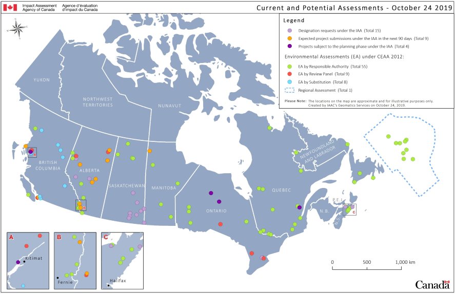
Summary
Map of Canada showing the locations of fifteen designation requests under the Impact Assessment Act, nine project submissions under the Impact Assessment Act expected in the next 90 days (at November 20, 2019), four projects subject to the planning phase under the Impact Assessment Act, and environmental assessments under the Canadian Environmental Assessment Act 2012, including fifty-five environmental assessments by the responsible authority, eight environmental assessments by review panel, eight environmental assessments by substitution, and one regional assessment.
C. Anticipated Decisions in Next 100 Days
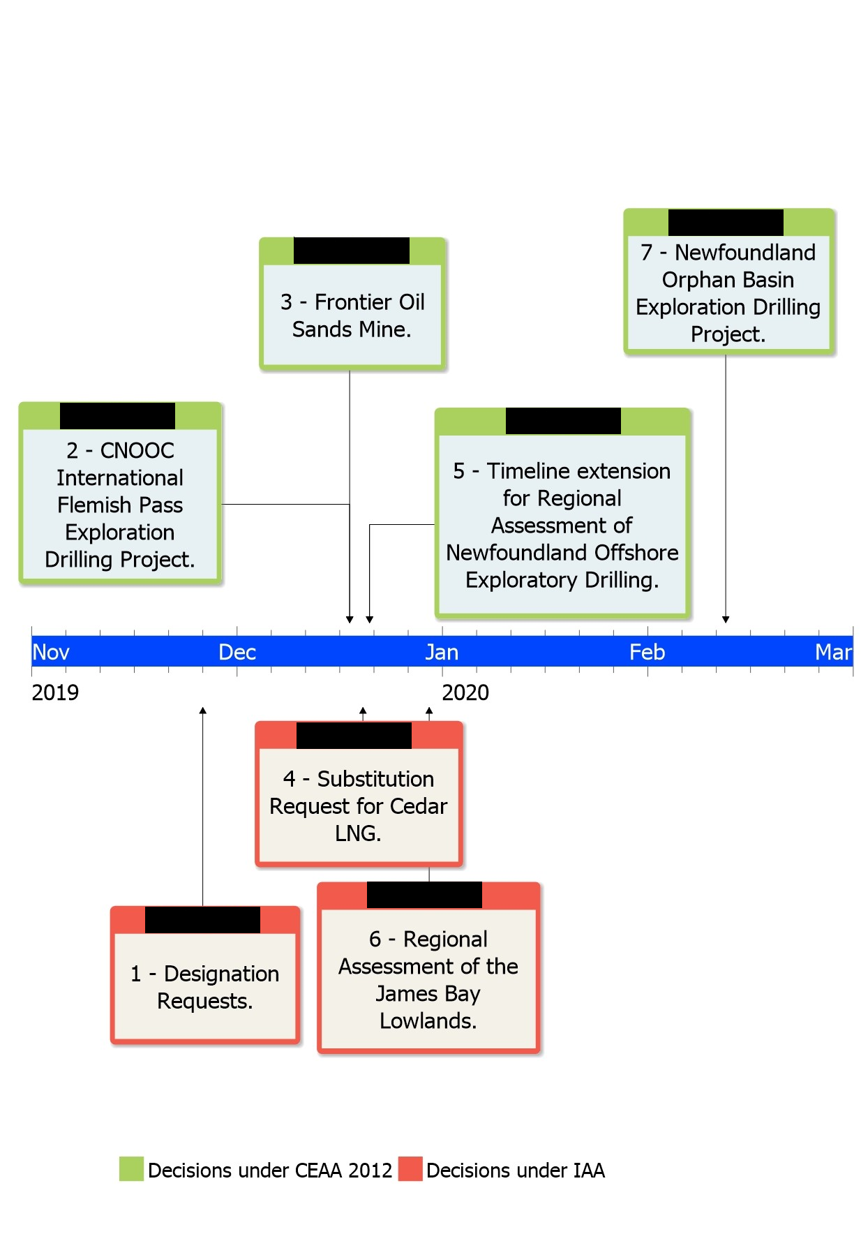
Summary
Timeline showing the date of anticipated decisions in the next 100 days as follows:
Under the Canadian Environmental Assessment Act, 2012:
- December 18, 2019: CNOOC International Flemish Pass Exploration Drilling Project
- December 18, 2019: Frontier Oil Sands Mine
- December 21, 2019: Timeline extension for Regional Assessment of Newfoundland Offshore Exploratory Drilling, and
- February 12, 2020: Newfoundland Orphan Basin Exploration Drilling Project.
Under the Impact Assessment Act;
- November 26, 2019: Designation requests
- December 20, 2019: Substitution request for Cedar LNG, and
- December 30, 2019: Regional Assessment of the James Bay Lowlands
Project |
Description |
Status |
Map |
|---|---|---|---|
Decision #1 |
|||
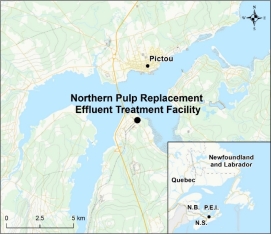
1a Northern Pulp Replacement Effluent Treatment Facility Project Northern Pulp Nova Scotia Corporation Phase: Designation Request Anticipated Decision Date: |
Northern Pulp Nova Scotia Corporation proposes to construct and operate a new effluent treatment facility for its pulp mill, which will discharge effluent into the Northumberland Strait. |
The Agency is reviewing the request for designation under the Impact Assessment Act. |
|
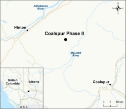
1b Coalspur Phase II Coalspur Mines (Operations) Ltd. Phase: Designation Request Anticipated Decision Date: |
The Project is a western expansion of the existing approved coal mine (Phase I) for the extraction and export of coal to market. The Project is located approximately 3.5 kilometres east of Hinton, Alberta. |
The Agency is reviewing the request for designation under the Impact Assessment Act. |
|
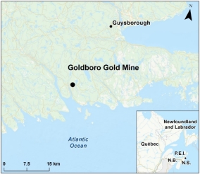
1c Goldboro Gold Mine Anaconda Mining Inc. Phase: Designation Request Anticipated Decision Date: |
Anaconda Mining is proposing to construction, operation, decommissioning and abandonment of a gold mine located on the eastern shore of Isaac’s Harbour, in Guysborough County, Nova Scotia, approximately 175 kilometres northeast of Halifax. The project would start as an open pit development and would transition to underground mining by year 3 of operation. |
The Agency is reviewing the request for designation under the Impact Assessment Act. |
|
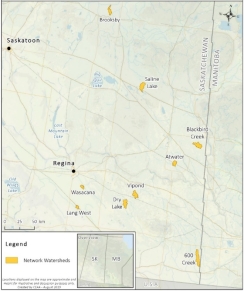
1d Saskatchewan Drainage Network (9 projects) Saskatchewan Water Security Agency Phase: Designation Request Anticipated Decision Date: |
Nine drainage network projects named in a Designation Request received on November 26, 2018 for the Saskatchewan Agricultural Drainage Networks. Each project is treated as separate designation request.
|
The Agency is reviewing the request for designation under the Impact Assessment Act. |
|
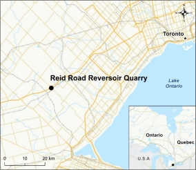
1e Reid Road Reservoir Quarry James Dick Construction Limited Phase: Designation Request Anticipated Decision Date: |
The Project would involve the extraction of sand, gravel and dolostone and would operate for approximately 20 years, subject. It is located approximately 1.5 kilometres west of the Hamlet of Campbellville in the Town of Milton. |
The Agency is reviewing the request for designation under the Impact Assessment Act. |
|
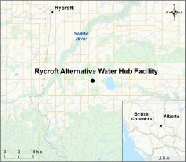
1f Rycroft Alternative Water Hub Facility Trace Water Solutions Ltd, Phase: Designation Request Anticipated Decision Date: |
Trace Water Solutions Ltd. is proposing to treat and recycle waste water generated by upstream petroleum industry for re-use within fracking activities near Woking, Alberta |
The Agency is reviewing the request for designation under the Impact Assessment Act. |
|
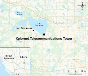
1g Xplornet Tele-communications Tower Xplornet Phase: Designation Request Anticipated Decision Date: |
Xplornet has proposed the building of a new tower at 29.9 metres starting with 12 antennas, willing to share tower space with other providers, and with a base that would support a 50-metre tower in Alberta. |
The Agency is reviewing the request for designation under the Impact Assessment Act. |
|
Decision #2 |
|||
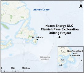
CNOOC International Flemish Pass Exploration Drilling Project CNOOC Petroleum North America ULC Phase: EIS and Draft EA Report EA Type: EA by Agency Anticipated Decision Date: |
CNOOC Petroleum North America ULC proposes the CNOOC International Flemish Pass Exploration Drilling Program within its offshore Exploration Licenses located in an offshore geographic area known as the Flemish Pass, approximately 400 kilometres east of St. John’s, Newfoundland and Labrador. The proponent proposes that wells could be drilled in its two exploration licences commencing in 2019. The Project would allow the proponent to determine the presence, nature and quantities of the potential hydrocarbon resource. |
The Agency released the draft EA Report and potential conditions on September 25, 2019 for a 30-day public and Indigenous comment period. |
|
Decision #3 |
|||
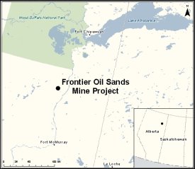
Frontier Oilsands Mine Teck Resources Limited Phase: Timeline 3 - Panel Report until EA Decision Assessment Type: Review Panel Anticipated Decision Date: |
The Frontier Oil Sands Mine Project (the Project), proposed by Teck Resources Limited includes the construction, operation and reclamation of an oil sands surface mine with a production capacity of about 240,000 barrels per day of bitumen. The Project is located in northeastern Alberta, approximately 110 kilometres north of Fort McMurray. The Project is a truck and shovel mine which includes two open pits, an ore preparation plant, a bitumen processing plant, tailings preparation and management facilities, cogeneration facilities, support utilities, disposal and storage areas, river water intake, a fish habitat compensation lake, roads, airfield and camp. The estimated project area is over 24,000 hectares. If the Project is approved, the proponent proposes to start producing oil in 2026. |
July 25, 2019 - The Joint Review Panel submitted its Report containing its conclusions, rationale and recommendations regarding the potential environmental effects of the proposed project to the Minister of Environment and Climate Change |
|
Decision #4 |
|||
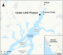
Cedar LNG Cedar LNG Export Development Ltd. Phase: Planning Assessment Type: IA by Agency Anticipated Decision Date: |
Cedar LNG Export Development Ltd. is proposing to construct and operate a floating liquefied natural gas (LNG) processing facility and marine export terminal near Kitimat, British Columbia. The proposed project would process and liquefy natural gas to produce approximately 3 to 4 million tonnes of LNG per year and include storage capacity for up to 250,000 cubic metres of LNG. The proposed project would have a lifespan of at least 25 years. |
BC submitted a substitution request on September 17, 2019. Public comment period ran until October 20, 2019 on the initial Project Description and on B.C.'s request for substitution. The Agency provided the Summary of Issues to the proponent on October 30, 2019 |
|
Decision #5 |
|||
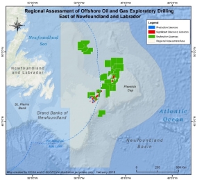
Regional Assessment of Offshore Oil and Gas Exploratory Drilling East of Newfoundland and Labrador Phase: Report Assessment Type: Regional Assessment Anticipated Decision on Extension Request Date: |
The Regional Assessment will focus on the effects of existing and anticipated offshore oil and gas exploratory drilling in the offshore area east of Newfoundland and Labrador. The Regional Assessment aims to improve the efficiency of the environmental assessment process as it applies to oil and gas exploration drilling, while at the same time ensuring the highest standards of environmental protection continue to be applied and maintained. The assessment will build upon the experience and knowledge gained in assessing previous projects, reduce duplication in processes and information, and result in more efficient project reviews for exploration projects. |
The Final Agreement to Conduct the Regional Assessment of Offshore Oil and Gas Exploratory Drilling East of Newfoundland and Labrador has been signed and a Committee was established on April 15, 2019. |
|
Decision #6 |
|||
Regional Assessment of the James Bay Lowlands Phase: Request Assessment type: Regional Assessment Anticipated Decision Date: |
On October 1, 2019, the Aroland First Nation requested the Minister establish a committee to conduct a regional assessment of the James Bay Lowlands (or Ontario’s Far North) for the mining sector and related infrastructure. This would include the Ring of Fire. |
The Agency is reviewing the request and preparing a recommendation for the Minister. |
Not available |
Decision #7 |
|||
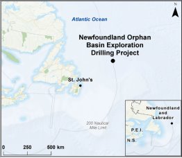
Newfoundland Orphan Basin Exploration Drilling Project BP Canada Energy Group ULC Phase: EIS and Draft EA Report Assessment Type: EA by Agency Anticipated Decision Date: |
BP Canada Energy ULC proposes the Newfoundland Orphan Basin Drilling Project within its offshore exploration licences (1145, 1146, 1148, and 1149) in the geographic area known as the Orphan Basin, located approximately 350 kilometres east of St. John's, Newfoundland and Labrador. The proponent proposes that up to 20 exploration wells could be drilled in its exploration licences commencing in 2019 or 2020. The Project would allow the proponent to determine the presence, nature and quantities of the potential hydrocarbon resource. |
The Agency is drafting the EA Report. |
|
D. Other Assessments
Project |
Description |
Status |
Map |
|---|---|---|---|
Laurentia Project: Port of Quebec Deep-Water Wharf - Beauport Sector QPA-APQ Phase: EIS and Draft EA Report Assessment Type: EA by Agency (Designated) Anticipated Decision Date: |
The Quebec Port Authority is proposing the extension of the existing wharf line by 610 metres in order to add two 16-metre deep-water berths at its Beauport Sector bulk shipment facilities. The Project includes creation of 17.5 hectares of new land at the back of the wharf for container handling facilities, continuation of an existing railway track on the Port Authority's property. |
An email was sent to the Quebec Port Authority on October 16, 2019 asking for a detailed description of the project update. A second part of a second request for information was sent to the proponent on 23 August 2019. A first part of a second request for information was sent to the proponent on August 9, 2019. |
|
James Bay Lithium Mine Galaxy Lithium Canada Phase: EIS and Draft EA Report EA Type: EA by Agency Anticipated Decision Date: |
The James Bay Lithium Mine Project is located on the Eeyou Istchee territory in the Nord-du-Québec administrative region of Québec approximately 10 kilometres south of the Eastmain River, 100 kilometres east of James Bay and the Eastmain Cree village. Galaxy Lithium (Canada) inc. (the proponent) is looking to open and operate an open-pit lithium mine. As proposed, the project includes an open-pit, an ore concentrator, tailings/waste rock/ore/overburden storage areas as well as accompanying infrastructure. The mine would have a production capacity of approximately 5480 tonnes per day. The mine life is estimated at 15 to 20 years. |
The proponent submitted its EIS to the Agency on February 18, 2019. The Agency has issued first information request package to the proponent on June 27, 2019 |
|
Rose Lithium - Tantalum Mining Project Corporation Éléments Critiques Phase: EIS and Draft EA Report Assessment Type: EA by Agency Anticipated Decision Date: |
Critical Elements Corporation is proposing the construction, operation and decommissioning of an open pit tantalum and lithium mine located approximately 38 km north of Nemaska, in Québec. As proposed, the project includes the operation of an open pit, waste and tailings impoundment area, an industrial ore processing facility and the option of transforming concentrate off-site. The mine would produce about 4,500 tonnes of ore per day over a 17-year life span. |
Public comment period on the summary of the environmental impact statement (EIS) closed on April 5, 2019. The analysis of the EIS is ongoing. The Agency has issued first information request package to the proponent on June 27, 2019. |
|
Beaver Dam Atlantic Gold Corp. Phase: EIS and Draft EA Report Assessment Type: EA by Agency Anticipated Decision Date: |
Atlantic Gold Corporation is proposing the construction, operation, decommissioning, and reclamation of an open pit gold mine in Marinette, Nova Scotia. The Beaver Dam Mine Project would have an ore production rate of 5480 tonnes/day, over a four year period. Ore from the Project would be crushed and transported 37 kilometres by road to the Moose River (Touquoy) mine for processing. Components of the Project would include an open pit, a materials storage facility, mine haul roads, mine infrastructure for crushing and haul-out, and road upgrades. The Project would rely on the mined-out Touquoy Pit for wet tailings disposal. |
The Agency has completed its technical review of the revised EIS and has determined that additional information is required in the form of additional Information Requests, which have been provided to the proponent on May 8 and June 12, 2019. |
|
Energie Saguenay GNL Québec Inc. Phase: EIS and Draft EA Report Assessment Type: EA by Agency Anticipated Decision Date: |
GNL Québec Inc. is proposing the construction and operation of a natural gas liquefaction (LNG) facility and export terminal in the borough of La Baie, in Saguenay, Quebec. The site of the project is located near the Grande-Anse marine terminal (Port of Saguenay). The main infrastructures are the natural gas liquefaction facilities with a production capacity of 11 million tonnes per year, port infrastructures for marine tanker loading of LNG, LNG storage tanks and support infrastructures. The wharf would be designed to accommodate vessels with a capacity of 100,000 deadweight tonnage (DWT). The operation could start in 2025 and would last a minimum of 25 years. |
Additional information was requested from the proponent on the Environmental Impact Statement on August 20, 2019. A letter was sent to the proponent informing them that the environmental assessment will now include the analysis of the environmental effects of marine transportation related to the project in the Saguenay River to Escoumins in the Lower St. Lawrence Estuary. Inquiries could be forwarded to the proponent for this purpose during the project analysis. |
|
Milton Logistics Hub CN Phase: Timeline 2 - Appointment of Panel Members until Panel Report Assessment Type: Review Panel Anticipated Decision Date: |
The Canadian National Railway Company is proposing the construction and operation of a railway yard with more than 20 kilometres of track located in Milton, Ontario, about 50 kilometres west of Toronto. |
July 20, 2019 – The Review Panel closed the record for the review and will prepare its report to be submitted to the Minister of Environment and Climate Change. |
|
WesPac WesPac Midstream LLC Phase: EIS and Draft EA Report Assessment Type: Substitution Anticipated Decision Date: |
WesPac Midstream – Vancouver LLC (WesPac) proposes the construction and operation of a new marine terminal facility located on Tilbury Island, along the South Arm of the Fraser River in Delta, British Columbia. The WesPac Tilbury Marine Jetty Project includes the loading of liquefied natural gas (LNG) onto LNG carriers and barges for export to local and global markets. The facility is expected to operate for a minimum of 30 years. |
On March 20, 2019, BC's EAO started the 180-day review of the proponent's Application for an Environmental Assessment Certificate (equivalent to an EIS). At the proponent's request, on August 6, 2019, the EAO suspended the provincial EA timeline to allow the proponent to gather supplemental analysis required for the revised marine shipping scope that the Minister established on July 9, 2019. |
|
Contrecoeur Port Terminal Expansion Project MPA-APM Phase: EIS and Draft EA Report Assessment Type: EA by Agency Anticipated Decision Date: |
The Montreal Port Authority proposes the construction of a container port terminal with a maximum annual capacity of 1.15 million containers on its property located in Contrecoeur, approximately 40 kilometres downstream from Montreal. The project would include the construction of a 675-metre dock for two berths to accommodate vessels between 39,000 and 75,400 deadweight tonnage (DWT). The project would also include a seven track classification yard, a container storage and handling area, an intermodal rail yard, support facilities, rail and road accesses, a truck control area and a viaduct on Route 132. |
Additional information was requested from the proponent to complete the EIS on June 6, 2017 and is expected at the end of 2019. |
|
Roberts Bank Terminal 2 Port Metro Vancouver Phase: Timeline 2 - Appointment of Panel Members until Panel Report Assessment Type: Review Panel Anticipated Decision Date: |
Port Metro Vancouver proposes the construction and operation of a new three-berth marine container terminal located at Roberts Bank in Delta, British Columbia, approximately 35 kilometres south of Vancouver. Located next to the existing Deltaport and Westshore Terminals, the Project would provide an additional 2.4 million twenty-foot equivalent units of container capacity per year at Roberts Bank. |
The Review Panel has closed the record and will prepare its report to be submitted to the Minister of Environment and Climate Change. |
|
Deep Geologic Repository for Low and Intermediate Level Radioactive Waste Ontario Power Generation Phase: Timeline 3 - Panel Report until EA Decision Assessment Type: Review Panel Anticipated Decision Date: |
The project is a proposal by Ontario Power Generation (OPG) to prepare, construct and operate a deep geologic disposal facility on the Bruce Nuclear Site within the municipality of Kincardine, Ontario. The DGR would be designed to manage low and intermediate waste produced from the continued operation of OPG-owned nuclear generations at Bruce, Pickering and Darlington, Ontario. |
The Minister of Environment and Climate Change requested additional information on the environmental assessment from the proponent on August 21, 2017. |
|
Central Ridge Exploration Drilling Project Equinor Canada Ltd. Phase: EIS and Draft EA Report Assessment Type: EA by Agency Anticipated Decision Date: |
Equinor Canada Ltd. is proposing to conduct an exploration drilling project within its offshore exploration licences in the Central Ridge Area, located approximately 375 kilometres east of St. John's, Newfoundland and Labrador, in the Atlantic Ocean. As proposed, the Central Ridge Exploration Drilling Project would allow the proponent to determine the presence, nature, and quantities of the potential hydrocarbon resource in exploration licences 1159 and 1160. |
The Notice of Commencement was posted on July 5, 2019. The EIS Guidelines were provided to the proponent on the same date. |
|
Project 6 All-season Road Manitoba Infrastructure Phase: EIS and Draft EA Report Assessment Type: EA by Agency Anticipated Decision Date: |
Manitoba Infrastructure proposes to construct 138 kilometres of all-season road on provincial Crown land. The all-season road project, designed as a 2-lane, gravel public highway, would consist of three sections of intersecting road located on the east side of Lake Winnipeg. These road sections would begin at the reserve boundaries of the Manto Sipi Cree Nation, the Bunibonibee Cree Nation & God’s Lake First Nation. Two bridges over God’s River and Magill Creek could also be constructed as part of the project. |
The Agency requested additional information from the proponent on June 26, 2019. |
|
Springbank Off-Stream Reservoir Project Alberta Transportation Phase: EIS and Draft EA Report Assessment Type: EA by Agency Anticipated Decision Date: |
The Government of Alberta (Alberta Transportation) proposes to construct flood mitigation infrastructure on lands adjacent to the Elbow River, approximately 15 kiometres west of Calgary, Alberta. As proposed, the Springbank Off-Stream Reservoir Project would divert flood waters during extreme flood events from the Elbow River to an adjacent wetland. The flood waters would be stored in a temporary reservoir before being diverted back into the river. The proposed project would consist of an off-stream storage reservoir, a diversion structure and channel, an off-stream storage dam, outlet works, and road modifications. |
The proponent submitted its EIS to the Agency on March 29, 2018. |
|
Grassy Coal Riversdale Resources Limited /Benga Mining Limited Phase: Timeline 2 - Appointment of Panel Members until Panel Report Assessment Type: Review Panel Anticipated Decision Date: |
Benga Mining Limited, a wholly owned subsidiary of Riversdale Resources Limited, is proposing to construct and operate an open-pit metallurgical coal mine near the Crowsnest Pass, approximately 7 kilometres north of the community of Blairmore, in south-west Alberta. As proposed, the production capacity of the project would be a maximum of four million tonnes of coal per year, over a mine life of about 25 years. |
September 9, 2019 – The Joint Review Panel invited public comments until October 24, 2019, on the additional information submitted by the proponent related to the Environmental Impact Assessment. |
|
Lake St. Martin Water Diversion Manitoba Infrastructure and Transportation Phase: EIS Guidelines Assessment Type: EA by Agency Anticipated Decision Date: |
Construction and operation of two outlet channels and associated works, to mitigate the impacts of flooding in Lake Manitoba and Lake St. Martin. The proposed Lake Manitoba Outlet Channel runs from Lake Manitoba to Lake St. Martin, is 23 kilometres long, and has a diversion capacity of 212 cubic metres per second. The proposed Lake St. Martin Outlet Channel runs from Lake St. Martin to Lake Winnipeg, is 23 kilometres long, and has a diversion capacity of 326 cubic metres per second. |
The Agency is conducting a conformity review on the EIS received from the proponent on August 30, 2019. |
|
Sukunka Coal Glencore Canada Corporation Phase: EIS and Draft EA Report Assessment Type: Substitution Anticipated Decision Date: |
Glencore (formerly Xstrata Coal Canada) proposes to develop and operate an open pit coal mine located approximately 55 kilometres south of Chetwynd and 40 kilometres west of Tumbler Ridge, in northeast British Columbia. The Project will produce up to 3 million tonnes of hard coking coal per year for export to overseas steel manufacturers. The mine life is expected to exceed 20 years. The Project is proposed within critical habitat of the Quintette herd of Southern Mountain Caribou. |
The timeline for the EA is currently suspended to advance discussions with federal and provincial experts about the direction of Southern Mountain Caribou recovery, including the Quintette herd that overlaps with the Project. B.C.'s EAO is also preparing its draft Assessment Report in consultation with the Agency. |
|
Kitimat LNG Expansion KM LNG Operating General Partnership Phase: EIS Guidelines Assessment Type: Substitution Anticipated Decision Date: |
KM LNG Operating General Partnership is proposing to expand the Kitimat LNG Project (archived Registry reference number 05-03-10430), a liquefied natural gas (LNG) production and marine export facility located at Bish Cove, near Kitimat, British Columbia. As proposed, the Kitimat LNG Expansion Project would increase the facility's LNG production capacity by more than 50%, to 18 million tonnes per year. The expansion would include the addition of a third LNG train, a LNG containment tank, marine berth infrastructure, and increased shipping. |
The Notice of Commencement and the Minister's decision on BC's Request for Substitution were posted on August 20, 2019. EAO will inform the Agency before finalizing the Application Information Requirements. |
|
Fifteen Mile Stream Atlantic Mining NS Corp Phase: EIS and Draft EA Report Assessment Type: EA by Agency Anticipated Decision Date: |
Atlantic Gold Corporation is proposing the construction, operation, decommissioning, and reclamation of an open pit gold mine in Nova Scotia. The Fifteen Mile Stream Gold Project would include open pits, stockpiles, materials storage facilities, mine haul roads, mine infrastructure for crushing, and tailings storage. The Fifteen Mile Stream Project is at an early stage of development, with a Mineral Resource estimate in place. |
The proponent submitted the EIS to the Agency on October 4, 2019. The Agency is conducting a conformity review of the document. |
|
Cochrane Hill Atlantic Gold Corp. Phase: EIS and Draft EA Report Assessment Type: EA by Agency Anticipated Decision Date: |
Atlantic Mining NS Corp is proposing the construction, operation, decommissioning, and reclamation of an open pit gold mine in Nova Scotia. The Cochrane Hill Gold Project would include open pits, stockpiles, materials storage facilities, mine haul roads, mine infrastructure for crushing, and tailings storage. The Cochrane Hill project is now at the feasibility stage. |
The EIS Guidelines were provided to the proponent on January 4, 2019. |
|
Delta Grinding Facility Project Lehigh Hanson Materials Limited Phase: Substitution Assessment Type: Substitution Anticipated Decision Date: |
Lehigh Hanson Materials Limited is proposing to construct, operate and decommission a grinding facility with a marine terminal adjacent to its existing cement plant facility located on Tilbury Island in Delta, British Columbia. As proposed, the Delta Grinding Facility Project would produce up to 650,000 tonnes of supplementary cementitious material per year when fully operational, and would have an operational life of at least 40 years. |
The Agency posted the Notice of Commencement and Substitution Decision on May 7, 2019. EAO to inform the Agency before finalizing the Application Information Requirements. |
|
BHP Canada Exploration Drilling Project BHP Petroleum (New Ventures) Corporation Phase: EIS and Draft EA Report Assessment Type: EA by Agency Anticipated Decision Date: |
BHP Petroleum (New Ventures) Corporation is proposing the BHP Orphan Basin Exploration Drilling Project within its offshore Exploration Licenses 1157 and 1158, located approximately 325 kilometres northeast of St. John's, Newfoundland and Labrador. The Project would allow the proponent to determine the presence, nature and quantities of the potential hydrocarbon resource. |
The Notice of Commencement was posted on June 28, 2019. The EIS Guidelines were provided to the proponent on the same date. |
|
Tilt Cove Exploration Drilling Project Suncor Energy Phase: EIS and Draft EA Report Assessment Type: EA by Agency Anticipated Decision Date: |
Suncor Energy Inc. is proposing the Tilt Cove Drilling Project within its offshore Exploration License 1161, located approximately 300 kilometres southeast of the St. John's, Newfoundland and Labrador. The Project would allow the proponent to determine the presence, nature and quantities of the potential hydrocarbon resource. |
The Notice of Commencement was posted on June 28, 2019. The EIS Guidelines were provided to the proponent on the same date. |
|
Mine Fire Lake North Champion Iron Mines Ltd. Phase: EIS and Draft EA Report Assessment Type: EA by Agency Anticipated Decision Date: |
Champion Iron Mines Ltd. is proposing the construction, operation and decommissioning of an open-pit mine and an iron concentrate processing plant on the mine site located near Fermont, Quebec. The proposed project consists also of the construction of a railway less than 10 kilometres to connect the mining project to a railway linking Fermont and Sept-Îles. The proponent predicts that the mine would generate 65,700 tonnes per day for a period of 25 years. |
The EIS Guidelines were provided to the proponent on January 15, 2013. EA is on hold at the proponent's request due to poor market conditions. |
|
Bay du Nord Equinor Canada Ltd. Phase: EIS and Draft EA Report Assessment Type: EA by Agency Anticipated Decision Date: |
Equinor (formerly Statoil Canada Ltd.), in partnership with Husky Oil Operations Limited, is proposing to install and operate a floating offshore oil and gas production facility in the Flemish Pass, approximately 450 kilometres east northeast of St. John’s, Newfoundland and Labrador, in the Atlantic Ocean. As proposed, the Bay du Nord Development Project would consist of the offshore construction, installation, hook-up and commissioning, drilling and life-of-field well support, operations and maintenance, and decommissioning of an oil and gas production installation. As proposed, the Bay du Nord Development Project would be in operation for approximately 30 years, with the potential for additional wells and tie-backs to the production facility. |
The EIS Guidelines were provided to the proponent on September 26, 2018. On November 8, 2018, the proponent was sent a draft MOU between the Agency and Canada-Newfoundland and Labrador Offshore Petroleum Board on the integrated environmental assessment and regulatory review of the Bay du Nord Development Project. |
|
West Flemish Pass Exploration Drilling Project Chevron Canada Phase: EIS and Draft EA Report Assessment Type: EA by Agency Anticipated Decision Date: |
Chevron Canada Limited is proposing the West Flemish Pass Exploration Drilling Project within its Exploration License 1138 offshore Newfoundland and Labrador, located approximately 375 kilometres east of the Island of Newfoundland. The Project would allow the proponent to determine the presence, nature and quantities of the potential hydrocarbon resource. |
The Notice of Commencement was posted on December 20, 2018. The EIS Guidelines were provided to the proponent on December 20, 2018. |
|
Foxtrot Rare Earth Element Mine Search Minerals Phase: EIS and Draft EA Report Assessment Type: EA by Agency Anticipated Decision Date: |
The Project would be located in southeast Labrador approximately 36 kilometres southeast of Port Hope Simpson and approximately 10 kilometres west of St. Lewis. The first phase of the Project would involve developing an open pit at a rate of 2000 tonnes per day (6 months of the year, over 8 years). The second phase would involve underground mining at a rate of 1000 tonnes per day (year round, over 6 years). Finished product would be shipped via the Trans Labrador Highway. The life of the mine is anticipated to be 14 years. The Project would consist of: a 10-kilometre pipeline to transport sulphuric acid; an 11-kilometre transmission line along with generator upgrades; road upgrades and approximately 500 metres of new road; administrative, accommodation, and maintenance infrastructure, as well as explosives storage; acid bake/water leach processing facility (dry stack tailings); waste rock and low grade stockpiles; and a 2.5-kilometre effluent pipeline. |
The EIS Guidelines were provided to the proponent on March 2, 2018. |
|
Trois-Rivières Port Facilities Expansion Project TRPA-APTR Phase: EIS and Draft EA Report Assessment Type: EA by Agency Anticipated Decision Date: |
The Trois-Rivières Port Authority is proposing an expansion project to increase the transshipping and storage capacity of the port. The project will consist of installing a multi-user terminal with a transshipping area, a short-term storage area, connecting wells and pipes the length of the wharfs, as well as an access road on the west side. Three new 231-metre berths will be built. A retaining wall and riprap are also planned for the far western end of the new facilities. |
Additional information was requested from the proponent to complete the EIS on June 6, 2017, and is expected at the beginning of 2020. |
|
Boat Harbour Remediation Nova Scotia Lands Inc. Phase: EIS and Draft EA Report Assessment Type: EA by Agency Anticipated Decision Date: |
In accordance with the provincial Boat Harbour Act, the use of Boat Harbour for the reception and treatment of effluent must cease no later than January 31, 2020. Once effluent treatment operations have ceased, NS Lands Inc. (the proponent) will remediate Boat Harbour and associated lands to restore the area back to a tidal estuary. |
The EIS Guidelines were provided to the proponent on May 31, 2019. The EIS is expected from the proponent in January 2020. |
|
Southeastern Newfoundland Offshore Exploration Drilling Project ExxonMobil Canada Ltd. Phase: EIS and Draft EA Report Assessment Type: EA by Agency Anticipated Decision Date: |
ExxonMobil Canada Limited is proposing the South Eastern Newfoundland Offshore Exploration Drilling Project within its offshore Exploration License 1136 in the South Eastern region offshore Newfoundland and Labrador, located between 445 kilometres east of the Island of Newfoundland and about 1200 kilometres east of Prince Edward Island. The Project would allow the proponent to determine the presence, nature and quantities of the potential hydrocarbon resource. |
The Notice of Commencement was posted on November 5, 2018. The EIS Guidelines were provided to the proponent on November 5, 2018. |
|
Lynn Lake Gold Project Alamos Gold Inc. Phase: EIS and Draft EA Report Assessment Type: EA by Agency Anticipated Decision Date: |
Alamos Gold Inc. is proposing an open pit gold mine and metal mill located within 45 kilometres of Lynn Lake, Manitoba. The Project will be located at two past producing underground mine sites (MacLellan Mine Site and Gordon Mine Site) previously owned by Carlisle Goldfields Limited. |
The EIS Guidelines were provided to the proponent on November 6, 2017. The EIS is expected to be submitted in March 2020. |
|
Lac Windfall Mine Project Osisko Mining Corporation Phase: EIS and Draft EA Report Assessment Type: EA by Agency Anticipated Decision Date: |
Osisko Mining Inc. is proposing the construction, operation and decommissioning of a underground gold mine located on the Eeyou Istchee-James Bay Territory, about 75 kilometres southeast of the Cree village of Waswanipi and 115 kilometres east of Lebel-sur-Quévillon, Quebec. The Lac Windfall Mine Project would have an ore production capacity of approximately 1900 tonnes per day over a period of up to 10 years. Additional project components would include an ore processing plant, a tailings pond, ore, waste rock and overburden storage areas, two operating ramps and the widening of a bridge. |
The EIS guidelines were provided to the proponent on September 27, 2017. The proponent is planning to submit the EIS to the Agency in February 2020. |
|
Hwy 905 Stony Rapids– Lake Athabasca (Fond-du-Lac) Ministry of Hwys & Infrastructure Phase: EIS and Draft EA Report Assessment Type: EA by Agency (Designated) Anticipated Decision Date: |
The Saskatchewan Ministry of Highways and Infrastructure (SMHI) is proposing to construct an all-weather road from Stony Rapids to the south shore of Lake Athabasca near Fond-du-Lac in northern Saskatchewan. The project includes: 88.5 kilometres of all-weather road; watercourse crossings; temporary structures, including construction roads, work camps and water withdrawal facilities; aggregate and borrow pits; and all physical works and undertakings associated with the fish habitat compensation plan. |
The EA is on hold at the request of the proponent as of January 9, 2017. |
|
Bending Lake Iron Project Ambershaw Metallics Inc. Phase: EIS Guidelines Assessment Type: EA by Agency Anticipated Decision Date: |
Ambershaw Metallics Inc., a subsidiary of Legacy Hill Resources, is proposing the construction, operation, decommissioning and abandonment of an open-pit iron ore mine and an on-site metal mill, located 49 kilometres southwest of Ignace, Ontario. As proposed, the Bending Lake Iron Project would have a 30- to 40-year mine life with an ore production capacity of 23 000 tonnes per day. The metal mill would have an ore input capacity of 25 000 tonnes per day. |
The EIS Guidelines were provided to the proponent on October 4, 2019. |
|
Valentine Gold Project Marathon Gold Phase: EIS and Draft EA Report Assessment Type: EA by Agency Anticipated Decision Date: |
Marathon Gold is proposing the expansion and development of four near-surface, pit-constrained gold deposits near Millertown, Newfoundland. Valentine Gold is Marathon Gold's flagship project. |
The guidelines were finalized and provided to the proponent on July 17, 2019, and were posted to the registry on July 18, 2019. The proponent is expected to submit the EIS in May 2020. |
|
Ruddock Creek Ruddock Creek Mining Corporation Phase: EIS Guidelines Assessment Type: Substitution Anticipated Decision Date: |
Ruddock Creek Mining Corporation is proposing the construction, operation, and decommissioning of a new underground zinc-lead mine located between the headwaters of Ruddock Creek and Oliver Creek in the Scrip Range of the Monashee Mountains, approximately 155 kilometres northeast of Kamloops and 28 kilometres east of Avola, British Columbia. The Project, as proposed, would have an ore production capacity of 3000 tonnes per day over an anticipated mine life of eight years. |
BC EAO to inform the Agency before finalizing the Application Information Requirements. |
|
Timiskaming Dam-Bridge of Quebec Replacement Project Public Services and Procurement Canada Phase: EIS and Draft EA Report Assessment Type: EA by Agency Anticipated Decision Date: |
Public Services and Procurement Canada is proposing to replace the Quebec Timiskaming dam-bridge located 65 kilometres northeast of North Bay, Ontario, and bordered by the city of Temiskaming, Quebec, to the east. As proposed, the project will result in the replacement of the Quebec Timiskaming dam-bridge, a structure that regulates water without generating electrical power. Its deck supports a two-lane roadway connecting the provinces of Quebec and Ontario. This complex includes two independent dams located on both sides of Long Sault Island on the Ottawa River: the Quebec dam-bridge and the Ontario dam-bridge, which was replaced in 2014. The new structure will be approximately 75 metres long and will have 10 bays: five with vertical sluice gates and five working with wooden beam weirs. The road deck will consist of two traffic lanes as well as a sidewalk. The construction of the new dam-bridge will be spread over a period of 30 months. |
The EIS Guidelines were provided to the proponent on August 21, 2018. The proponent is planning to submit its EIS during summer 2020. |
|
Cape Ray Gold Nordmin Resource and Industrial Engineering Ltd. Phase: EIS and Draft EA Report Assessment Type: EA by Agency Anticipated Decision Date: |
Matador Mining Ltd. propose to develop, operate, decommission and reclaim a gold and silver mine, mill and processing operation at the Cape Ray Property near Port aux Basques, Newfoundland. |
The EIS Guidelines were provided to the proponent on April 7, 2017. The proponent met with the Agency on March 11, 2019, and is expecting to submit its EIS in September 2020. |
|
Michel Coal Project North Coal Limited Phase: EIS and Draft EA Report Assessment Type: EA by Agency Anticipated Decision Date: |
North Coal Limited, a wholly-owned subsidiary of Australia’s CoalMont Pty Ltd., proposes to construct, operate, decommission and abandon a metallurgical coal mine with three open-pits in the Elk Valley, located approximately 15 kilometres southeast of Sparwood, British Columbia. As proposed, the Michel Coal Project would produce between 2.3 and 4 million tonnes of raw coal per year, over a mine life of between 15 and 30 years. |
The EIS Guidelines were provided to the proponent on January 15, 2016. The proponent submitted a revised project description to the Agency on August 22, 2018. The proponent has not informed the Agency when it expects to submit an EIS. |
|
Crown Mountain NWP Coal Canada Ltd. Phase: EIS and Draft EA Report Assessment Type: EA by Agency Anticipated Decision Date: |
NWP Coal Canada Ltd. is proposing to construct and operate an open-pit metallurgical coal mine in the East Kootenay Region, approximately 12 kilometres from the District of Sparwood in southeastern British Columbia. As proposed, the production capacity of the project would be 3.7 million tonnes per year, over a mine life of about 16 years. |
The EIS Guidelines were provided to the proponent on February 20, 2015. The proponent has not informed the Agency when it expects to submit an EIS. |
|
St. Lawrence Fluorspar Marine Shipping Terminal Project Canada Fluorspar Inc. Phase: EIS Guidelines Assessment Type: EA by Agency Anticipated Decision Date: |
Canada Fluorspar (NL) Inc. (CFI) is proposing to build and operate a dedicated marine shipping facility, west of the current AGS Mine & Mill operations in Mine Cove, Little Lawn Harbour, St. Lawrence, to serve as an export wharf for its acid-grade Fluorspar Concentrate (200,000 tonnes per year) and Construction Aggregates (2 metric tonnes per year). |
The Final EIS Guidelines were provided to the proponent on September 30, 2019. |
|
Griffith Mine Project Lithium Energy Products Inc. (formerly Northern Iron Corp.) Phase: EIS and Draft EA Report Assessment Type: EA by Agency Anticipated Decision Date: |
Lithium Energy Products Inc. (formerly Northern Iron Corp.) proposes the redevelopment of the former Griffith Mine within the Township of Ear Falls in northwestern Ontario. The Project would involve the construction, operation, and decommissioning of a past-producing open pit iron ore mine. The proposed project would produce approximately 16,000 tonnes of ore per day, with a mine life of approximately 20 years. The iron ore would be milled on-site to produce slightly more than 4000 tonnes per day of hot briquetted iron. |
The EIS Guidelines were issued on June 24, 2013. |
|
Kwispaa LNG Kwispaa LNG (CF) Limited Partnership Phase: EIS Guidelines Assessment Type: EA by Agency Anticipated Decision Date: |
The facility at Sarita Bay would treat, liquefy and store the natural gas as a liquid (LNG) ready to be loaded onto LNG carriers for export. LNG carriers would ship the LNG from Sarita Bay to customers around the world, primarily in Asia. The LNG facility would be expected to operate for at least the next 25 years. |
On February 27, 2019, the Agency issued an Information Request to the proponent asking how the proponent intends to proceed with the Project. The proponent provided a partial response that it is pausing development of the Project for 6-12 months. The federal timeline is paused on day 76 of 365 until a complete response to the information request is provided. The province requested that the Substitution Request determination be delayed. The Agency sent a transition letter per subsection 181(2) of the Impact Assessment Act that the required information from the Information Request must be provided by August 28, 2022, or the process under the Canadian Environmental Assessment Act, 2012 would be terminated. |
|
Joyce Lake Labec Century Iron Ore Phase: EIS and Draft EA Report Assessment Type: EA by Agency Anticipated Decision Date: |
Labec Century Iron Ore is proposing the construction, operation, and decommissioning of an open-pit iron mine located approximately 20 kilometres northeast of Schefferville in Newfoundland and Labrador. As proposed, the mine would produce up to four million tonnes of ore per year over a life span of up to seven years. The ore would be transported to the existing rail owned by Tshiuetin Rail Transportation Inc. for transportation to the Port of Sept-Îles. The mine and mine infrastructure would consist of: an open pit, dewatering of Joyce Lake, waste rock disposal, tailings management, processing and support infrastructure, access and haulage roads, and a rail loop. |
The EIS Guidelines were provided to the proponent on March 5, 2013. |
|
Springpole Gold Project First Mining Gold Corp. Phase: EIS and Draft EA Report Assessment Type: EA by Agency Anticipated Decision Date: |
First Mining Gold Corp. is proposing the construction, operation, decommissioning, and abandonment of an open-pit gold/silver mine and onsite metal mill, located approximately 110 kilometres northeast of Red Lake, Ontario. As proposed, the Project would have an ore production capacity of 60,000 tonnes per day over an 11-year mine life. The on-site metal mill would have an ore input capacity of 44,000 tonnes per day and would operate for 12 years. |
The EIS Guidelines were provided to the proponent on June 19, 2018. |
|
More Creek Hydro Project Alaska Hydro Corportation Phase: EIS and Draft EA Report Assessment Type: EA by Agency Anticipated Decision Date: |
Alaska Hydro Corporation, a British Columbia based company, is proposing to construct and operate a 75-megawatt hydroelectric facility with reservoir storage, approximately 130 kilometres north of Stewart, in British Columbia, and 95 kilometres east of the Alaskan border. The project would be located on More Creek, which drains into the Iskut River and then the transboundary Stikine River. As proposed, the More Creek Hydroelectric Project would generate approximately 348 gigawatt hours of electricity per year, and its reservoir storage area would cover approximately 2680 hectares of the More Creek drainage area basin. The proposed project would include the construction and operation of a powerhouse and energy generation facilities, a transmission line, a water intake, a dam and reservoir, concrete works, as well an access road and other construction related components. |
The EIS Guidelines were provided to the proponent on December 22, 2016. On August 8, 2017, the proponent notified the Agency that they are not in a position to proceed with the provincial side of the coordinated EA. As a result, the timeline associated with next steps is uncertain. |
|
Century Gold Project Goldcorp Canada Ltd Phase: EIS and Draft EA Report Assessment Type: EA by Agency Anticipated Decision Date: |
Porcupine Gold Mines, a subsidiary of Goldcorp Canada Ltd. is proposing the construction, operation, decommission and abandonment of a new metal mill as well as the expansion of its existing Dome Mine, located in Timmins, Ontario. The area of mine operations for the existing Dome Mine would increase by over 50%. As proposed, the Century Gold Project would operate for 10 to 16 years, and include an open-pit gold mine with an ore production capacity of 70,000 tonnes per day. The on-site metal mill would also have an ore input capacity of 70,000 tonnes per day. |
The EIS Guidelines were provided to the proponent on November 16, 2018. |
|
Mine Hopes Advance Oceanic Iron Ore Corporation Phase: EIS and Draft EA Report Assessment Type: EA by Agency Anticipated Decision Date: |
The Project consists of the construction, operation and decommissioning of an open-pit iron ore mine near Aupaluk, in Nunavik. The proponent estimates that the mine will generate from 10 to 20 million tonnes of iron ore concentrate product per year over a planned operation period of 48 years with a daily average extraction rate of 72,000 to 144,000 tonnes. The ore would be concentrated by a process based on gravity separation. For the shipment of the iron ore to European and Asian markets, the proponent is proposing to construct a marine terminal consisting of a 330-metre loading wharf, a tug moorage area, a commercial wharf and a causeway. The concentrate would then be pumped to the marine terminal through a 26-kilometre long pipeline for shipping. The proponent may opt for a 190 MW thermal generating station as an energy source for his operations. |
The EIS Guidelines were provided to the proponent on December 10, 2012. The proponent has not provided a timeframe for the submission of its EIS to the Agency. Last communication with the proponent was in December 2018 and the path forward for this project was still not established. |
|
Kipawa Rare Earths Project Matamec Explorations inc. Phase: EIS and Draft EA Report Assessment Type: EA by Agency Anticipated Decision Date: |
Matamec Explorations Inc. proposes the construction, operation and decommissioning of a rare earths open-pit mine about 40 kilometres east of the municipality of Kipawa. The proposed project would process 1.3 million tonnes of ore per year over a 15-year operation period with a daily average extraction rate of 3650 tonnes. The concentrate would be shipped by truck or by train and then by boat to Asian or European refineries. The proposed project would also include the construction of a concentrator, a power line as well as ancillary buildings such as storage, a laboratory and administrative offices. |
The EIS Guidelines were provided to the proponent on May 31, 2013. The proponent has not provided a time frame for the submission of its EIS to the Agency. Based on an article published in October 2018, Matamec Exploration would have merged with Canada Strategics Metals to form Quebec Precious Metals. |
|
Arctos Anthracite Arctos Anthracite Joint Venture Phase: EIS Guidelines Assessment Type: Substitution Anticipated Decision Date: |
Arctos Anthracite Joint Venture proposes the construction, operation and decommissioning of an anthracite coal mine in northwestern British Columbia. The site of the proposed mine is about 90 kilometres southeast of Iskut, 160 kilometres northeast of Stewart, and 240 kilometres north of Hazelton. The proposed project would produce about 3 million tonnes per year of anthracite coal over a mine life of approximately 25 years. The proposed project would also include constructing a 147-kilometre extension to an existing railway from its current terminus to the mine site. |
BC EAO to inform the Agency before finalizing the Application Information Requirements. |
|
Aley Taseko Mines Limited Phase: EIS Guidelines Assessment Type: Substitution Anticipated Decision Date: |
Aley Corporation Limited proposes to construct and operate an open-pit niobium mine, located approximately 130 kilometres north of Mackenzie in north-central British Columbia. As proposed, the project would process ten thousand metric tonnes of niobium ore per day, for a total of 94 million tonnes of ore over a mine life of 27 years. |
BC EAO to inform the Agency before finalizing the Application Information Requirements. |
|
Coal Mountain Project Teck Coal Limited Phase: EIS and Draft EA Report Assessment Type: EA by Agency Anticipated Decision Date: |
Teck Coal Limited is proposing to expand its existing Coal Mountain Operations. The Coal Mountain Phase 2 Project, an open-pit coal mine, would be located in southeastern British Columbia, approximately 15 kilometres south of Sparwood, and 20 kilometres northwest of the proponent's current operations. The proposed project would include an approximate disturbance area of 1000 hectares, and would produce approximately 2.25 million metric tonnes of clean coal per year over an estimated mine life of 34 years. |
The EIS Guidelines were provided to the proponent on January 12, 2015. The proponent has not informed the Agency when it expects to submit an EIS. |
|
Bingay Main Centermount Coal Limited Phase: EIS and Draft EA Report Assessment Type: EA by Agency Anticipated Decision Date: |
Centremount Coal Limited is proposing the construction, operation, and decommissioning of an open pit and underground coal mine located approximately 21 kilometres north of Elkford, in southeastern British Columbia. As currently proposed, the Project would produce 1 million tonnes of coal per year over a mine life of 13 years. |
The EIS Guidelines were provided to the proponent on March 19, 2013. The proponent has not informed the Agency when it expects to submit an EIS. |
|
Kitimat Clean Refinery Kitimat Clean Ltd. Phase: EIS Guidelines Assessment Type: Review Panel Anticipated Decision Date: |
Kitimat Clean Ltd. is proposing the construction, operation, decommissioning and abandonment of a new oil refinery located approximately 13 kilometres north of Kitimat, British Columbia. As proposed, the Kitimat Clean Refinery Project would include a refinery, a power-plant, a rail yard, a marine terminal and a bitumen storage facility. A new pipeline would also be constructed to deliver fuel to the proposed marine terminal, located approximately 12 kilometres south of Kitimat. The project is expected to process approximately 400,000 barrels of bitumen per day over a lifespan of at least 50 years. |
Additional information was requested from the proponent related to the description of key project components on September 9, 2016. |
|
Marathon PGM Stillwater Canada Inc. Phase: Timeline 2 - Appointment of Panel Members until Panel Report Assessment Type: Review Panel Anticipated Decision Date: |
Marathon PGM Corporation is proposing to construct, operate and decommission an open pit platinum group metals and copper mine approximately 10 kilometres from Marathon, Ontario. The proposed project would include three open pits, an ore processing plant, tailings and mine rock storage facilities, site access roads, a 7 kilometre power transmission line, explosives factory and magazines, water management facilities, ancillary mine infrastructure and associated activities. The rate of production would be approximately 22,000 tonnes per day with a proposed operating mine life of approximately 11.5 years. |
The Minister of Environment and Climate Change disbanded the Joint Review Panel established to conduct the environmental assessment of the proposed project on October 31, 2014. |
|
Carbon Creek Coal Project Cardero Coal Limited Phase: EIS Guidelines Assessment Type: Substitution Anticipated Decision Date: |
Cardero Coal Ltd proposes to develop and operate an open pit metallurgical coal mine located approximately 60 kilometres northwest of Chetwynd and 40 kilometres west of Hudson's Hope, in northeast British Columbia. The proposed project would involve open pit surface mining followed by combined open pit and underground mining. The production rate would be 4.1 million metric tonnes of metallurgical coal per year, over a mine life of 20 years. |
BC EAO to inform the Agency on the next steps once the proponent resumes environmental assessment. |
|
Amisk Hydro AHP Development Corporation Phase: Timeline 1 - Referral to Panel until appointment of panel members Assessment Type: Review Panel Anticipated Decision Date: |
AHP Development Corporation is proposing to construct and operate a 330-megawatt hydroelectric facility on the Peace River, approximately 15 kilometres upstream of Dunvegan, in northwestern Alberta. As proposed, the Amisk Hydroelectric Project would generate approximately 1875 gigawatt hours of electricity per year. The proposed project would involve the construction and operation of a powerhouse, spillway, headpond, fish passage, boat passage, a connecting transmission line and substation, as well as access roads and other construction related components. |
The EIS Guidelines were provided to the proponent on February 12, 2016. |
|
Pacific Future Energy Refinery Pacific Future Energy Corporation Phase: Timeline 1 - Referral to Panel until appointment of panel members Assessment Type: Review Panel Anticipated Decision Date: |
Pacific Future Energy Corporation is proposing the construction, operation and decommissioning of an oil refinery located on Dubose Flats, 32 kilometres north of Kitimat, in northwest British Columbia. The Pacific Future Energy Refinery Project would be capable of refining 31,795 m³ per day (200,000 barrels per day) of NEATBITTM (nearly solid bitumen) over a project life of at least 60 years. The Project would include a new railway yard with 7 tracks and a total track length of 20.9 kilometres, and have a petroleum storage capacity of 860,043 m³. |
The Agency issued the final EIS Guidelines to the proponent on December 12, 2016, for the preparation of an EIS. |
|
Assessments by other Responsible Authorities (RA) |
|||
2021 NGTL System Expansion Project NOVA Gas Transmission Ltd. Phase: EA in Progress Assessment type: EA by other RA (CER) |
NOVA Gas Transmission Limited (NGTL), a wholly owned subsidiary of Trans Canada, has filed an application for the 2021 NGTL System Expansion Project. NGTL proposes to build and operate approximately 344 kilometres of 1,219 mm (NPS 48) outside diameter natural gas pipeline and associated facilities in northwestern Alberta, from approximately Grande Prairie to north of Calgary, including three compressor station additions. If approved, the project would “loop” or add new pipeline parallel or adjacent to, the existing NGTL System. In its application, NGTL said the project was needed to transport natural gas from areas of increasing production in northwestern Alberta and northeastern BC to intra-Alberta and export markets. If approved, NGTL plans to begin operating the project by April 2021. |
The former National Energy Board (NEB) concluded hearings on Oral Indigenous Knowledge on the 2021 NOVA Gas Transmission Ltd. (NGTL) System Expansion Project. The sessions took place in Grande Prairie (Apr 30, 2019) and concluded in Calgary (May 13-17, 2019). |
|
Edson Mainline Expansion Project Nova Gas Transmission Ltd. Phase: EA in Progress Assessment type: EA by other RA (CER) |
NOVA Gas Transmission Ltd. (NGTL) is applying to the National Energy Board under section 52 of the National Energy Board Act for approval to construct and operate the Edson Mainline Expansion Project (the Project) in Alberta. The Project consists of two sections of 1,219 mm (nominal pipe size 48) natural gas pipeline, including the 40.2-kilometre long Elk River Section and the 44.7-kilometre long Alford Creek Section, and associated facilities. The associated facilities include three mainline block valves, one control valve and bypass assembly, ten crossover valves, a receiver facility, and temporary access roads. The Project will cross 31 watercourses located in the North Saskatchewan River watershed, notably the Brazeau River, Nordegg River, Elk River, Prairie Creek, and the Clearwater River. NGTL is proposing to construct both pipeline sections from November 2021 to April 2022. |
On August 27, 2019, an environmental assessment commenced. |
|
North Corridor Expansion Project Nova Gas Transmission Ltd Phase: EA in Progress Assessment type: EA by other RA (CER) |
NOVA Gas Transmission Ltd. (NGTL) is applying to the National Energy Board under section 52 of the National Energy Board Act for approval to construct and operate the North Corridor Expansion Project (the Project) in Alberta. The Project consists of three natural gas pipelines: two sections of 1,219 mm (nominal pipe size 48 inch), including the 24-kilometre long North Star Section 2 and the 32-kilometre long Red Earth Section 3, and a third section of 1,219 mm (nominal pipe size 36 inch) which is 25 kilometres long and called the Bear Canyon North Extension on the Northwest Mainline Loop No.2. The Project also includes a unit addition at Hidden Lake North Compressor Station and launcher and receiver facilities for cleaning and in-line inspection. Temporary infrastructure required for construction could include temporary access roads, borrow pits/dugouts, slurry pits, stockpile sites, laydown yards, contractor yards and construction camps. The Project will cross 6 watercourses located in the Peace River Basin; named watercourses include the Notikewin River, Loon River, Hunt Creek, and Bear Canyon Creek. NGTL is proposing to commence construction at the compressor station in November 2019 and commence all three pipeline sections from September 2021 to April 2022. |
An EA commenced on August 27, 2019. |
|
Micro Modular Reactor Project at Chalk River Global First Power Phase: EA in Progress Assessment type: EA by other RA (CNSC) |
Global First Power is proposing the site preparation, construction, operation, and decommissioning of a single small modular reactor, using Micro Modular Reactor (MMR) technology. The proposed project is located at the Chalk River Laboratories site, in Renfrew County, Ontario, approximately 200 kilometres northwest of Ottawa. The proposed project includes a nuclear plant, which would contain a MMR High Temperature Gas-cooled Reactor that would provide process heat to an adjacent plant, via molten salt. The MMR would produce approximately 15 Megawatt (thermal) of process heat to generate electrical power and/or heat, over an operating life-span of 20 years. Under the Nuclear Safety and Control Act, Global First Power's proposal requires approval and licensing by the Canadian Nuclear Safety Commission (CNSC). An environmental assessment (EA) conducted under the Canadian Environmental Assessment Act, 2012 is required, and an EA decision affirming that the proposed activities will not cause significant adverse environmental effects, before the CNSC can make a licensing decision on this proposal. |
An EA commenced on July 15, 2019 |
|
Millennium Uranium Mine Cameco Phase: EA in Progress Assessment type: EA by other RA (CNSC) |
Cameco Corporation is proposing to develop an underground uranium mine located in the southeastern part of the Athabasca Basin in northern Saskatchewan, approximately 600 kilometres north of Saskatoon. The proposed Millennium mine would produce 150,000 to 200,000 tonnes of ore annually for six to seven years. Ore and associated waste materials would be transported to a licensed mill along a new 21-kilometre access road that would connect to the existing road network. |
CNSC posted a Notice of Adjournment of Public Hearing on June 9, 2014. On May 15, 2014, Cameco informed the CNSC that it does not wish to proceed with the licensing of the Project at this time, due to current economic conditions. |
|
Rook I Project NexGen Energy Ltd. Phase: EA in Progress Assessment type: EA by other RA (CNSC) |
NexGen Energy Ltd. (NexGen) is proposing to develop an underground uranium mine on the Patterson Lake peninsula in the southwestern Athabasca Basin in northern Saskatchewan, approximately 155 kiloemtres north of the town of LaLoche, SK. The proposed Rook l mine would produce up to 14 million kilograms of U3O8 annually for 24 years. Under the Nuclear Safety and Control Act, NexGen's proposal requires approval and licensing by CNSC. An EA conducted under the Canadian Environmental Assessment Act, 2012 is required, and an EA decision affirming that the proposed activities will not cause significant adverse environmental effects, before the CNSC can make a licensing decision on this proposal. This Project is also subject to the EA requirements of the Government of Saskatchewan. |
On May 2, 2019, the EA commenced and a public participation period is now underway. |
|
Wheeler River Project Denison Mines Corp. Phase: EA in Progress Assessment type: EA by other RA (CNSC) |
Denison Mines Corp. (Denison) is proposing to develop an in situ recovery uranium mining and processing operation located in the Athabasca Basin in northern Saskatchewan, approximately 600 kilometres north of the city of Saskatoon, 4 kilometres west of Highway 914 and midway between Cameco Corporation's Key Lake Mill and McArthur River Mine. The proposed Wheeler River mine would produce up to 5400 tonnes of U3O8 annually for twenty years. Under the Nuclear Safety and Control Act, Denison's proposal requires approval by the CNSC. An EA conducted under the Canadian Environmental Assessment Act, 2012 is required, and an EA decision affirming that the proposed activities will not cause significant adverse environmental effects, before the CNSC can make a licensing decision on this proposal. This Project is also subject to the EA requirements of the Government of Saskatchewan. |
September 25, 2019 – Comments received on the Project Description and CNSC responses were posted to the Registry. |
 |
In Situ Decommissioning of the Whiteshell Reactor Canadian Nuclear Laboratories Phase: EA in Progress Assessment type: EA by other RA (CNSC) |
Canadian Nuclear Laboratories (CNL) is proposing to decommission the Whiteshell Reactor #1 (WR-1 Reactor), a former nuclear research reactor that operated until 1985. The WR-1 Reactor is located at the Whiteshell Laboratories (WL) site in Pinawa, MB, approximately 100 kilometres northeast of Winnipeg, near the towns of Lac du Bonnet and Seven Sisters. |
CNL is currently addressing all comments received, as well as the CNSC's requests for information. CNL has indicated that additional time is required to complete these deliverables. As a result, the final EIS, originally expected in April 2018, and the public hearing, which had been tentatively planned for October 2018, are delayed. |
Not available on Registry |
Near Surface Disposal Facility Canadian Nuclear Laboratories Phase: EA in Progress Assessment type: EA by other RA (CNSC) |
The Near Surface Disposal Facility (NSDF) is a proposed engineered disposal facility for radioactive waste planned for the Chalk River Laboratories site (CRL). CNL has provided a revised project description, allowing for the NSDF to also accept intermediate-level waste, as opposed to solely low-level and mixed waste. All waste to be disposed at the NSDF will be required to meet the waste acceptance criteria established to assure compliance with operational and long-term safety requirements. The CRL site is located in Renfrew County, Ontario, on the shore of the Ottawa River, approximately 200 kilometres northwest of Ottawa. The site is situated within the boundaries of the Corporation of the Town of Deep River. |
The public comment period on the draft EIS for the proposed NSDF Project closed on August 16, 2017. CNL has indicated that additional time is required to complete these deliverables. As a result, timelines for the final EIS, originally expected in January 2018, and the public hearing, tentatively planned for July 2018, are delayed. A revised timeline for project deliverables will be made available to the public once finalized. |
Not available on Registry |
Nuclear Power Demonstration Closure Canadian Nuclear Laboratories Phase: EA in Progress Assessment type: EA by other RA (CNSC) |
CNL is proposing to decommission the Nuclear Power Demonstration Waste Facility, a former nuclear generating station that operated until 1987. The facility is located in Renfrew County, Ontario, on the south bank of the Ottawa River approximately 225 kilometres northwest of Ottawa. The structures that currently remain onsite include the main reactor building, a diesel generator, a ventilation stack, a pressure relief duct, a guardhouse, foundations from previously removed structures, two landfills, buried utilities and drainage systems, and temporary structures such as sea containers and portable washrooms. |
CNL is currently addressing all comments received from the public comment period on the draft EIS of February 13, 2018, as well as the CNSC's requests for information. CNL has indicated that additional time is required to complete these deliverables. As a result, the final EIS, originally expected in June 2018, and the public hearing, which had been tentatively planned for December 2018, are delayed. A revised timeline for project deliverables will be made available to the public once finalized. |
Not available on Registry |
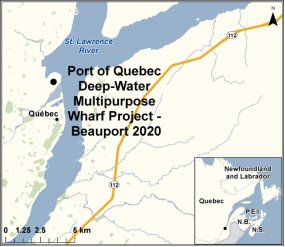
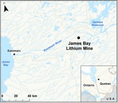
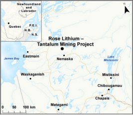
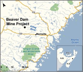
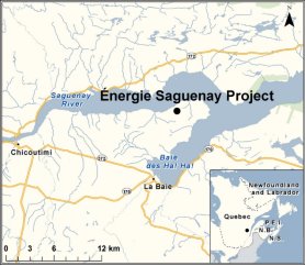
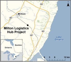
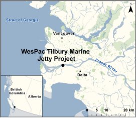
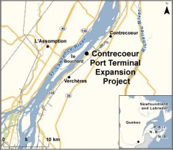
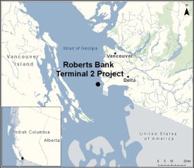
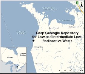
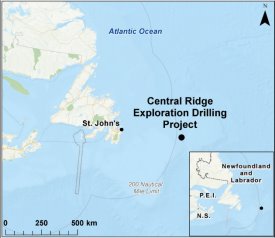
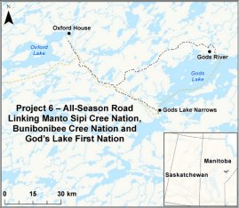
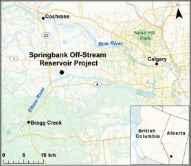
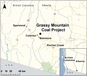
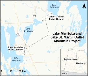
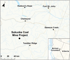
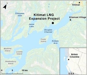
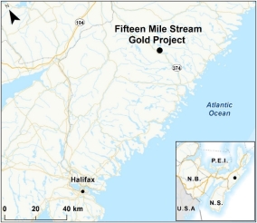
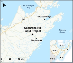
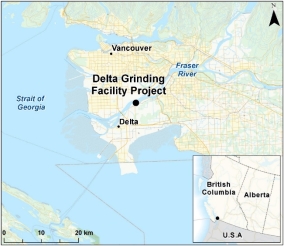
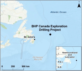
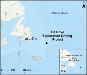
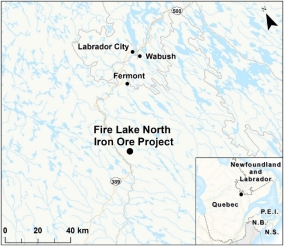
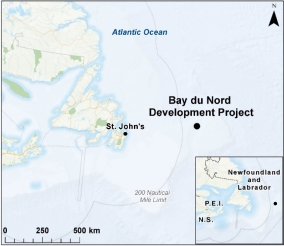
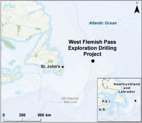
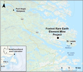
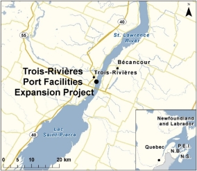
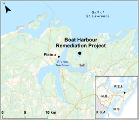
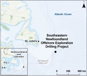
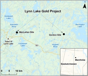
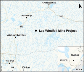
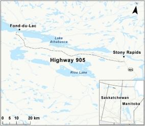
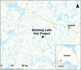
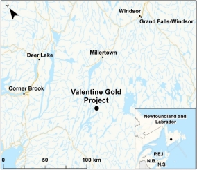
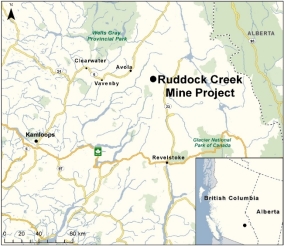
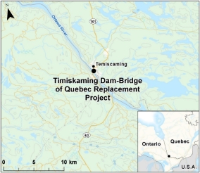
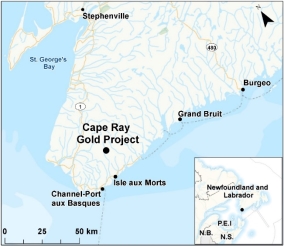
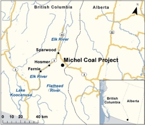
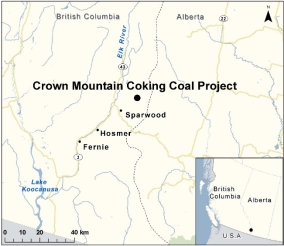
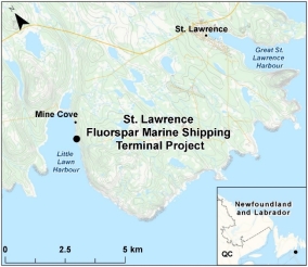
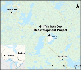
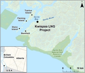
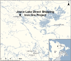
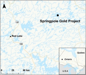
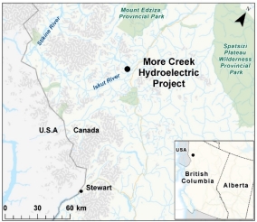
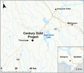

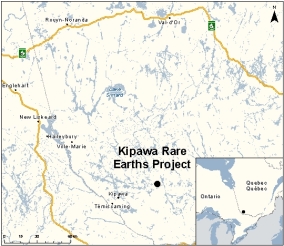
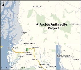
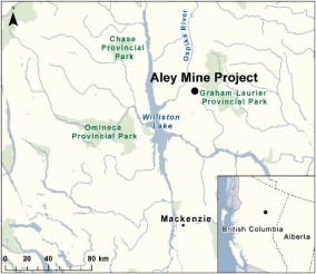
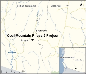
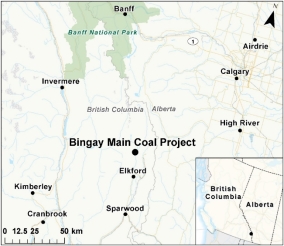
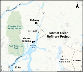
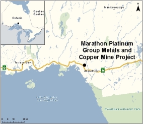


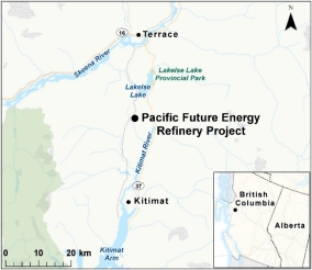
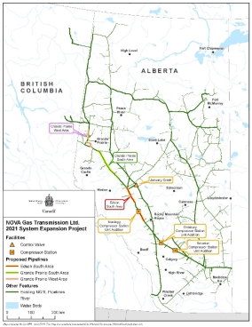

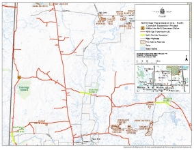
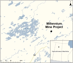

E. Current Impact Assessments
Project |
Description |
Status |
Map |
|---|---|---|---|
Marten Falls Community Access Road Marten Falls First Nation Phase: Planning Assessment Type: IA by Agency Anticipated Decision Date: |
Marten Falls First Nation is proposing the construction and operation, including maintenance, of an all-season multi-use community access road approximately 140 to 250 kilometres in length, connecting the northern end of Painter Lake forestry road to the community of Marten Falls. Marten Falls is located at the junction of the Albany and Ogoki rivers, approximately 170 kilometres northeast of Nakina, Ontario. As proposed, the Marten Falls Community Access Road Project could enable future access to potential mineral development activities in the Ring of Fire area. |
Public comment period on the initial Project Description concluded on October 1, 2019. The Agency provided the Summary of Issues to the Proponent on October 11, 2019 to inform the Detailed Project Description. |
|
Webequie Supply Road Project Webequie First Nation Phase: Planning Assessment Type: IA by Agency Anticipated Decision Date: |
Webequie First Nation is proposing the construction and operation, including maintenance, of a 107-kilometre all-season road connecting the Webequie Airport and the McFaulds Lake area in northern Ontario. The corridor would be approximately 35 metres in width in order to accommodate a two-lane gravel surface industrial supply road and could enable future infrastructure development such as transmission lines and broadband. As proposed, the Webequie Supply Road Project would connect Webequie First Nation to existing mineral exploration activities and potential future mineral development in the Ring of Fire area. The project could also become part of a future all-season road network connecting Webequie First Nation and the Ring of Fire area to the provincial highway system in Nakina and/or Pickle Lake. |
Public comment period on the initial Project Description concluded on October 1, 2019. The Agency provided the Summary of Issues to the Proponent on October 11, 2019 to inform the Detailed Project Description. |
|
Project Gazoduq GNL Québec Inc. Phase: Planning Assessment Type: Integrated Review Panel Anticipated Decision Date: IA determination: |
Construction and operation of an underground natural gas transmission line greater than 750 km long from the existing infrastructures in eastern Ontario to a futur natural gas liquefaction complex (Énergie Saguenay Project) in Saguenay. If IA is determined to be required, this project will be first integrated review between the Agency and CER. |
Public engagement period on the initial Project Description to run from October 22 to November 12, 2019. |
|
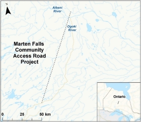
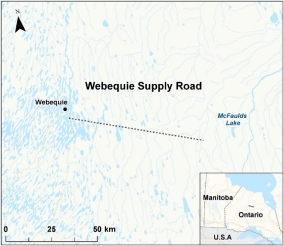
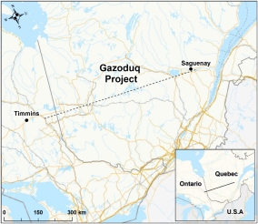
F. Anticipated Project Submissions in the Next 90 Days
Project |
Description |
Regional Office |
Anticipated Initial PD Received date |
Current Status |
|---|---|---|---|---|
REDACTED |
||||
REDACTED |
||||
REDACTED |
||||
REDACTED |
||||
REDACTED |
||||
REDACTED |
||||
REDACTED |
||||
REDACTED |
||||
4. Annexes
A. 2018-19 Year End Financial Statements
B. Impact Assessment Process FAQ
- Phase 1 FAQ
- Phase 2 FAQ
- Phase 3 FAQ
- Phase 4 FAQ
- Phase 5 FAQ