
Eastern Bridge in the National Capital Region
We’re taking steps to plan the new Eastern Bridge connecting Gatineau and Ottawa. This project will improve transportation, support economic growth and prepare for future needs in the National Capital Region (NCR).
On this page
- Project overview
- Project description
- Advantages of the new bridge
- Project timeline
- Project background: Studies and research
- Related links
Project overview
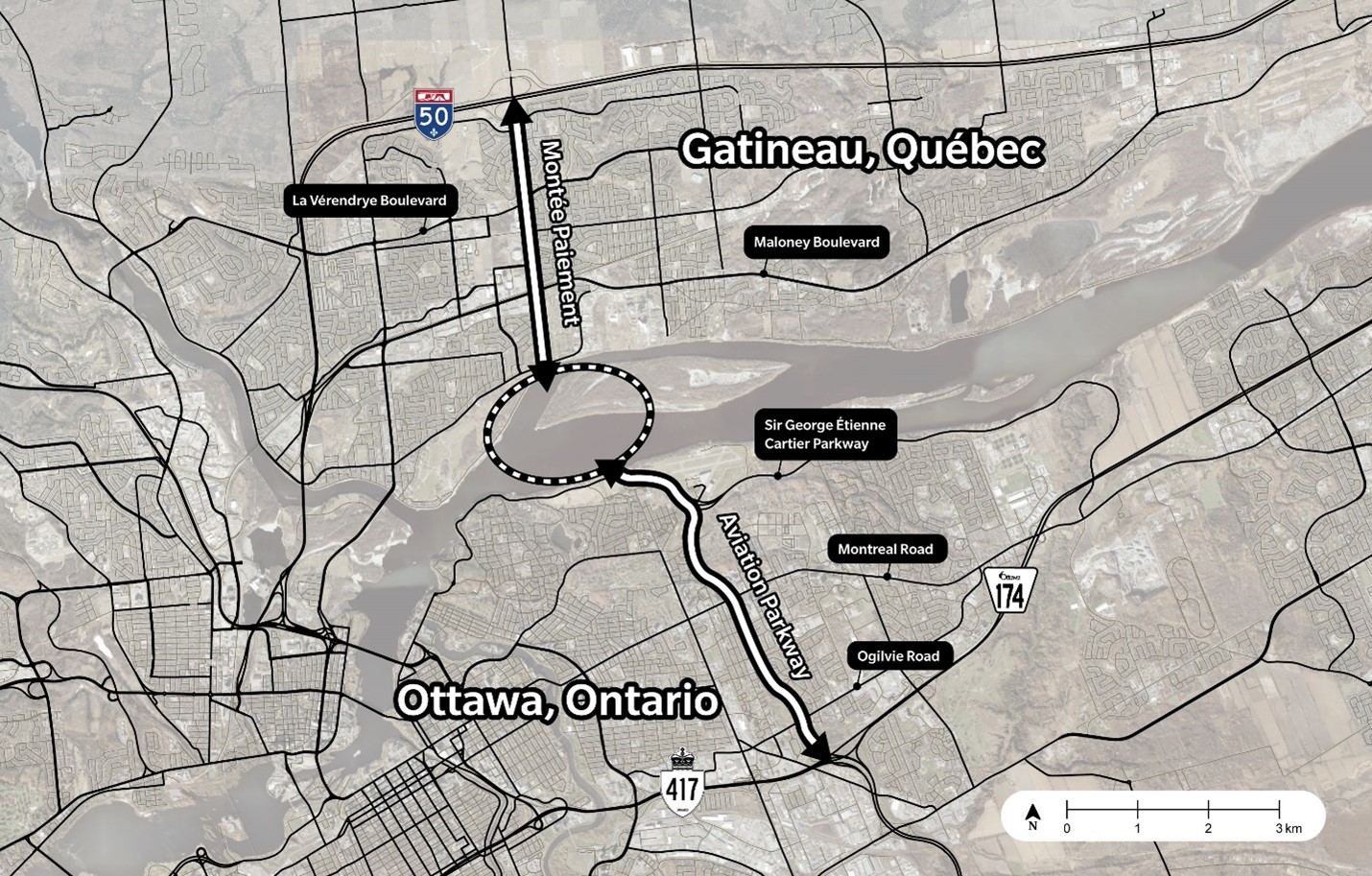
- Location
- From Montée Paiement in Gatineau, Quebec to the Aviation Parkway in Ottawa, Ontario
- Type of project
- New construction
- Lead department
- Public Services and Procurement Canada (PSPC)
- Project status
- Pre-planning phase
- Next steps
- Planning and design phase
Project description
The population in the NCR has doubled since the last crossing (the Portage Bridge) was built in 1973. With more people commuting between Ottawa and Gatineau, there’s a clear need for better transportation options.
To support this growth, we're using the Long-Term Integrated Interprovincial Crossings Plan to shape a transportation system in the NCR that’s more sustainable and connected. This plan looks at the current and future transportation challenges and uncertainties in the region. It also shows why a new bridge is important to improve travel and meet future needs.
We’re working with partners to advance the planning and design of the Eastern Bridge. PSPC is collaborating with the National Capital Commission (NCC) and a technical advisor as 1 team.
PSPC leads the overall project planning and delivery, which includes the design, procurement and construction of the bridge. As a member of the integrated project team, the NCC provides support to this project, namely in areas of transportation planning, impact assessment and engagement activities.
Location
Evaluations conducted over the last 15 years have consistently recommended the Montée Paiement–Aviation Parkway Corridor for the new bridge.
In 2024, we identified the Montée Paiement–Aviation Parkway Corridor as the preferred location. This location was selected because it offers strong benefits and is expected to have fewer impacts during construction and operation.
The new corridor will extend from Autoroute 50 at Montée Paiement in Gatineau to Highway 417 at the Aviation Parkway in Ottawa.
As the project will use existing roadways, the benefits of this corridor include:
- the lowest impacts to air quality and previously undisturbed natural environments, including a less mature tree canopy
- improved proximity to existing commercial properties in both municipalities, which stand to benefit from enhanced access via a new bridge
- a faster construction timeline
Advantages of the new bridge
There have been many studies looking at building a new bridge between Ottawa and Gatineau. Past studies concluded that we need a new bridge to improve interprovincial transportation and mobility.
Improved mobility for a growing population
The Eastern Bridge will provide more direct travel, offer more options, and provide new connections of the public transit networks.
- The NCR’s population is expected to reach nearly 2 million by 2050
- Existing bridges are at or near full capacity, especially the Macdonald-Cartier Bridge, used by an average of 75,000 vehicles daily (2025)
- Morning rush-hour congestion is expected to increase by 53% from 2011 to 2050
Improved freight transport
The bridge will:
- offer a new route for heavy trucks
- reduce traffic in central areas
- support smoother freight movement
According to the Interprovincial Truck Mobility Data Collection in the National Capital Region - National Capital Commission (PDF):
- 3,500 trucks cross the Ottawa River every day, and 72% of them use the Macdonald-Cartier Bridge
- 67% of heavy trucks travelling on the current King-Edward corridor have an origin or destination outside the immediate area
- more than 75% of trucks use a route that either starts or ends east of the Gatineau or Rideau rivers
Boosting economic development
By offering easier travel between provinces, the bridge will support local economies on both sides of the river. It will:
- ease travel between provinces
- encourage urban growth along major transportation routes
Improved resiliency
Past flooding events in 2017 and 2019 highlighted the vulnerability of existing infrastructure. The new bridge will:
- facilitate emergency response
- help the region adapt to climate change and natural disasters
Design highlights
The Montée Paiement–Aviation Parkway Corridor is expected to be about 12 kilometres long and would include the new bridge.
The new bridge is expected to feature:
- pedestrians and cyclist lane(s) separated from vehicular traffic
- personal and commercial vehicles lanes
- sustainable travel by investing in infrastructure for public transit
- improvements that make transportation more efficient and help reduce environmental impact
Project timeline
The project will take place in 4 stages with the bridge expected to be operational in 2034. The impact assessment process and the approach to the construction program could influence the implementation timeline. We’re currently in the pre-planning phase of the project.
The project will respect the region’s natural environment and cultural heritage. The scope of the project will be refined following the results of the technical studies, assessments and engagement activities.
Phase 1: Pre-planning (2019 to 2026)
- selected the corridor
- conducted geotechnical investigations
- retained a technical advisor
- engaged with the public, partners and stakeholders, including municipal and provincial partners and Indigenous communities (Report: Public participation round 1)
- continuing ecological studies
- initial ecological studies began in spring 2025 within the river area to avoid sensitive features through bridge design
- additional studies will be undertaken in 2026 for the rest of the corridor
- develop the initial project description to initiate the impact assessment process
- finalize the:
- performance criteria and the functional requirements
- planning and design principles, which will:
- align with the technical refresh of the Long-Term Integrated Interprovincial Crossings Plan
- reflect updated transportation projections
- integrate initial engagement feedback
- design selection framework which includes the multicriteria assessment tool
- develop the procurement strategy
- develop concept design options
Phase 2: Planning and design (2026 to 2028)
- finalize the impact assessment process and technical studies
- obtain Impact Assessment Act approval
- evaluate options using the design selection framework and multicriteria assessment tool
- identify and advance a preferred concept design
- seek feedback from Indigenous communities, the public and stakeholders
- seek approval of the design concept from the NCC Board of Directors, in accordance with the National Capital Act, as part of its regulatory federal approval authority
Phase 3: Procurement (2027 to 2028)
- procure the services for the owner’s engineer to support the project team during the construction stage
- advance the procurement process and award contracts for the final designer and builder via competitive requests for qualifications and proposals
Phase 4: Final design and construction (2029 to 2034)
- finalize the design
- seek feedback from Indigenous communities, the public and stakeholders
- seek approval of the final design from the NCC’s Board of Directors
- build the new bridge
Project background: Studies and research
Past research shows that the need for an interprovincial link east of the NCR has been recognized since 1915 to:
- unify the shores of Gatineau and Ottawa
- integrate transportation and mobility
The integrated project office has also commissioned many studies in recent years.
In 2024, the government:
- authorized further studies on the Montée Paiement–Aviation Parkway Corridor
- announced its commitment to a new multimodal bridge over the Ottawa River in the 2024 Fall Economic Statement