French River Dams Complex
Learn more about the French River Dams Complex and how the 3 dams on Lake Nipissing play a critical water management role for the lake, as well as for the length of the French River.
On this page
About the dam complex
The French River Dams Complex is comprised of 3 dams:
- the Little Chaudière Dam (built in 1914 and replaced in 1996)
- the Portage Dam
- the Big Chaudière Dam
The dams play an important role in managing Lake Nipissing water levels and regulating the flow of water into the French River. All 3 dams have vertical gates that can be adjusted to control the outflow at the dam.

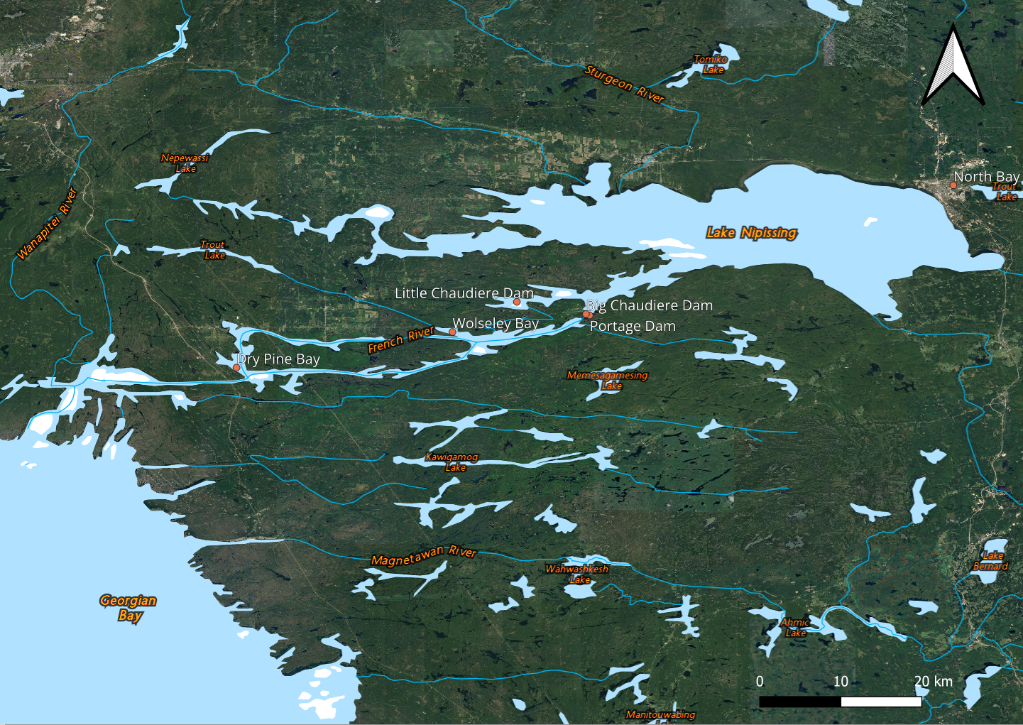
Long description for the map of the French River dams
A map showing the 3 French River dams is shown. The French river rises from Lake Nipissing and flows into the Georgian Bay. The section near Lake Nipissing contains a split where the river forms a ‘Y’ shape. The southern split is where the Big Chaudière Dam and the Portage Dam are located, while the northern split contains the Little Chaudière Dam. Further towards the Georgian Bay, there are also 2 bays, the closest is the Wolseley Bay and the furthest is the Dry Pine Bay.
As the owner and operator, our department works in cooperation with local stakeholders to maintain water levels suitable for navigation, reduce the impact of flooding and droughts, promote public safety around dams, and preserve the fishery.
The Dokis First Nation occupy approximately 16 hectares of land near and around the dams. Access to the French River dams is through the First Nations Reserve land.
The Dokis First Nation, along with the FirstLight Power, have developed a low-flow hydro power project adjacent to Portage Dam. This joint partnership is known as the Okikendawt Hydroelectric Project, which sells hydroelectric power to the Ontario Power Authority.
Little Chaudière Dam
The Little Chaudière Dam was originally completed in 1914 and replaced in 1996. It has 2 vertical gates.
Located within the French River Provincial Park, the dam is only accessible by boat.
Portage Dam
The Portage Dam was built in 1948 and replaced in 1992. It has 3 vertical gates.
The Okikendawt Generating Station, a privately owned structure built in 2015, is located adjacent to the Portage Dam.
Big Chaudière Dam
The Big Chaudière Dam was originally built between 1910 and 1916 at the outlet of Lake Nipissing.
The dam includes:
- a south channel dam with 1 vertical gate
- a north channel dam with 2 vertical gates
In 2016, the old dams were removed and replaced. The new dams were built slightly downstream from the original Big Chaudière dams.
The French River Basin
The French River Basin is a 19,000-square-kilometre watershed in northern Ontario. Within the watershed lies Lake Nipissing, which is the fourth-largest inland lake in Ontario covering over 850 square kilometres. From it, the French River runs 105 kilometres to the outlet at Georgian Bay.
The main tributaries into Lake Nipissing are the Sturgeon River, the Veuve River and the South River.
The watershed has a long and rich history as a traditional route for First Nations people and later for the fur trade as an important section of the Voyageur Route. In 1986, the French River was designated a Canadian Heritage River for its significance to the geography, culture and history of Canada.
Water management on the French River basin
Lake Nipissing is a large reservoir on the watershed used primarily for flood mitigation, but also as supporting fisheries and recreation on the lake and river.
As a measure to reduce the risk of flooding, every fall, we gradually open the French River dams to begin emptying the reservoir and continue to do so over the winter months. The goal is to empty the reservoir in time for the spring, where we typically see significant runoff, or excess water from snowmelt and rainfall. With the reservoir level starting empty and capturing a significant amount of runoff, we mitigate flooding on both the lake and river. As the reservoir fills, we aim to reach and maintain navigational levels between 195.75 metres to 195.95 metres through the summer months. The navigational season starts on the May long weekend and ends by mid-October.
Related links
- French River Dams Complex: Project to replace the boathouse and wharf and rehabilitate the workshop
- Watershed Management | North Bay-Mattawa Conservation Authority (English only)
- Surface Water Monitoring Centre | ontario.ca
- Flood Forecasting and Warning Program | ontario.ca
- Water management – OPG (English only)