
Radio Aids to Marine Navigation 2026: Part 3: Vessel Traffic Services
Table of Contents

The purpose of this Part is to describe to mariners the reporting procedures to be followed by vessels that are about to enter, leave or proceed within a Vessel Traffic Services (VTS) Zone in Canada. If a vessel enters a VTS Zone from outside Canadian waters, the master must ensure that a Sailing Plan is submitted at least 24 hours before entering Canadian waters. Additionally, within Canadian waters, there are reporting requirements based on geographical location, as set forth in the Vessel Traffic Services Zone Regulations (VTSZ Regulations SOR 2025-275), its applicable Schedules, and Navigation Safety Regulations, 2020 (NSR, 2020).
Pre-Arrival Information Report (PAIR)
The Canadian Marine Transportation Security Regulations (MTSR) require a Pre-Arrival Information Report (PAIR) to be filed 96 hours prior to entry into Canadian waters. Message format and contact information are found in Part 4 of this publication. This report is separate from VTS reporting requirements.
USA Notice of Arrival – West Coast
A 96-hour Notice of Arrival (NOA) must be filed in accordance with the 33 Code of Federal Regulations (CFR) Part 160 (dated February 28, 2003) directly to the United States Coast Guard National Vessel Movement Center (NVMC) via one of the following methods:
Email: sans@nvmc.uscg.gov
Telephone: 1-800-708-9823
Facsimile: 1-800-547-8724
The electronic Notice of Arrival/Departure (e-NOA/D) can be found at the NVMC website.
3.1 Canadian Coast Guard Responsibilities
There is no intention on the part of the Canadian Coast Guard to attempt to navigate or manoeuvre ships from a shore station, other than the given authority under the Canada Shipping Act, 2001 to manage vessel traffic; the master has the responsibility for the safe navigation of their vessel.
As per the Oceans Act, Section 41, the Minister responsible for Coast Guard services designates Marine Communications and Traffic Services (MCTS) officers for the delivery of VTS under subsection 126(2) of the Canada Shipping Act, 2001. An MCTS officer may, with respect to any vessel of a prescribed class that is about to enter or is within a VTS zone:
- grant a clearance to the vessel to enter, leave or proceed within the VTS zone;
- direct the master, pilot or person in charge of the deck watch of the vessel to provide, in the manner and at any time that may be specified in the direction, any pertinent information in respect of that vessel that may be specified in the direction;
- direct the vessel to use any radio frequencies in communications with coast stations or other vessel that may be specified in the direction; and
- direct the vessel at the time, between the times or before or after any event that may be specified in the direction;
- to leave the VTS zone,
- to leave or refrain from entering any area within the VTS zone that may be specified in the direction, or
- to proceed to or remain at any location within the VTS zone that may be specified in the direction.
Ferries and other vessels on regularly scheduled voyages may request a variation from requirements and conditions, as per Section 127 of the Canada Shipping Act, 2001. Formal variations to reporting requirements will be granted only where alternate arrangements to provide essential information are made and where the equivalent procedure or practice is deemed to be as safe as that required in the regulations.
Any vessel temporarily or permanently replacing another vessel which was granted a variation may avail itself of the same variation. This information must be communicated to MCTS.
Formal variations may be obtained by submitting a written request to the appropriate Regional MCTS Superintendent, Canadian Coast Guard (see Section 1.7 of this publication).
3.2 Marine Radiocommunications
Radiotelephone procedures used when communicating with an MCTS centre shall follow the standards established by the International Telecommunication Union (ITU), as set out in the Manual for Use by the Maritime Mobile and Maritime Mobile Satellite Services.
The master of a vessel shall ensure that they are able to maintain direct communication with MCTS when proceeding within a VTS Zone.
A continuous listening watch shall be maintained on the appropriate VTS sector frequency, as specified throughout Part 3 of this publication, on radio equipment that is located:
- in an area so as to maximize its safety and operational accessibility;
- in an accessible location from the vessel’s conning position and its operation;
- in an area to enable its monitoring and sending of distress signals or distress alerts, from the position from which the vessel is normally navigated.
If a vessel is not fitted with an additional radio installation, a continuous listening watch may be interrupted for a short period while the radio is being used to transmit or receive communications on another VHF radio frequency.
All communications should be expressed using the 24-hour system, and
- if the vessel is engaged on an international voyage, observe coordinated universal time (UTC);
- if the vessel is engaged on any other type of voyage, observe the local time of the area in which the vessel is navigating.
Navigation safety calls on designated VTS sector frequencies should not exceed one minute in duration and must contain information that is consistent with the safety requirement of the situation.
3.2.1 Marine Radiocommunication Difficulties
Where a vessel for any reason, other than shipboard equipment failure, is unable to establish direct communication with an MCTS officer to obtain the required clearance or after receiving a clearance, is unable to maintain direct communication with an MCTS officer, the master may nevertheless proceed on their route, but shall take all reasonable measures to communicate with an MCTS officer as soon as possible and obtain a clearance.
When communication difficulties arise due to language issues, English will be the language to use and follow the International Maritime Organization’s (IMO) Standard Marine Communication Phrases (IMO Resolution A.918 (22), 2001), which also includes the use of message markers.
3.2.2 Shipboard Equipment Failure
In the event of a shipboard equipment failure where the vessel is unable to establish or maintain direct communication with an MCTS officer, the vessel shall:
- if in a port or anchorage where the equipment can be repaired, remain there until the vessel is able to establish communications; or
- if not in a port or anchorage where the equipment can be repaired, proceed to the nearest reasonably safe port or anchorage on its route, when it is safe to do so, and remain there until it is able to establish communications.
3.3 Traffic Clearance
- A traffic clearance is an authorization for a vessel to proceed subject to such conditions as may be included in the authorization.
- A traffic clearance is based upon an MCTS officer’s analysis of a sailing plan, known traffic, waterway, and safety conditions.
- A traffic clearance does not eliminate the need for other authorizations required by other laws.
- Should any factor upon which the traffic clearance was provided alter to the detriment of safe navigation, the traffic clearance may be delayed, or other conditions may be attached to the traffic clearance.
3.4 Standard Vessel Traffic Service Reporting Template
The following is the Standard VTS Reporting template for all VTS Reports, with the requirement to complete applicable designators depending on the type of VTS Report.
| Designator | Function | Information Required |
|---|---|---|
| A | Vessel Identity | Vessel name, state flag, call sign, IMO ship identification number, Maritime Mobile Service Identity (MMSI) number |
| B | Time of Report | A 6-digit group (first two digits day of month, last four digits hours and minutes) in UTC (unless transiting in only one Time Zone) |
| C | Position (latitude and longitude) | A 4-digit group giving latitude in degrees and minutes suffixed with N (north) or S (south) and a 5-digit group giving longitude in degrees and minutes suffixed with E (east) or W (west) |
| D | Position (geographical) | True bearing (first 3 digits) and distance in nautical miles from a clearly identified landmark |
| E | Vessel’s Course | A 3-digit group (true course) |
| F | Vessel’s Speed | A 3-digit group in knots and tenths of knots |
| G | Last Port | Name of last port of call |
| H | Entry/Departure | Date/time (as expressed in (B)), and entry or departure (as expressed in (C) or (D)) |
| I | Destination and ETA | Name of port and expected date/time of arrival (as expressed in (B)) |
| J | Pilot | State whether a pilot is on board or date/time (as expressed in (B)) when anticipated to board |
| K | Exit | Date/time (as expressed in (B)) and point of exit (as expressed in (C) or (D)) or arrival at the vessel’s destination |
| L | Route | Intended track |
| M | Radiocommunications | State in full names of stations/frequencies guarded |
| N | Next Report | Date/time (as expressed in (B)) and/or position (as expressed in (C) or (D)) of next report |
| O | Draught | 4-digit group giving metres and centimetres of maximum present static draught |
| P | Cargo | Brief details of cargo and details of any dangerous cargoes, as well as harmful substances and gases that could endanger persons or the environment (pollutants) (see detailed reporting requirements) |
| Q | Defect, Damage, Deficiency, Limitations | Brief details of defects, damage, deficiencies, or other limitations (see detailed reporting requirements) |
| R | Pollution, Dangerous Goods Lost Overboard | Brief details of type of pollution (oil, chemicals, etc) or dangerous goods lost overboard including the position (as expressed in (C) or (D)) (see detailed reporting requirements) |
| S | Weather | Brief details of weather and sea conditions (including ice) prevailing |
| T | Agent | Details of name and particulars of vessel’s authorized representative or owner, or both, for provision of information (see detailed reporting requirements) |
| U | Vessel size and type | Details of length, breadth, tonnage, and type, etc., as required |
| V | Medic | Brief details of doctor, physician’s assistant, nurse, or personnel with medical training |
| W | Persons on Board | State number of persons on board |
| X | Remarks | Any other information (see detailed reporting requirements) |
| Y | Relay | Request to relay report to another system |
| Z | End of Report | No further information required |
3.5 Western VTS Zone Reporting Requirements
3.5.1 Application
The Vessel Traffic Services Zone Regulations (VTSZ Regulations SOR 2025-275 apply to the following vessels that are about to enter, leave or proceed within a VTS Zone as described in Schedule 1:
- vessels of 300 gross tonnage or more;
- vessels that are engaged in towing or pushing another vessel, if the combined gross tonnage is 500 gross tonnage or more; and,
- vessels that are carrying as cargo a pollutant or dangerous goods, or vessels that are engaged in towing or pushing such a vessel.
3.5.1.1 Additional application
Sections 3.5.2.2 to 3.5.2.6 of this publication also apply to the following vessels:
- A vessel that is 20m or more in length other than:
- A pleasure craft that is less than 30m in length, and
- A fishing vessel that is less than 24m in length and not more than 150 gross tonnage.
- A vessel that is engaged in towing or pushing another vessel or an object, other than fishing gear, unless the vessel and the other vessel or object being towed or pushed are within a log booming ground, if:
- The combined length of the vessel and the other vessel or object is 45m or more, or
- The length of the other vessel or object is 20m or more.
3.5.2 Reporting Requirements
3.5.2.1 Sailing Plan (SP) - 24 hour report (only applicable to vessels as described in Section 3.5.1)
- 24 hours if entering a VTS Zone from outside of Canadian waters, including Alaska, or as soon as feasible if the estimated time of arrival of the vessel is less than 24 hours after the time the vessel departed from their last port of call.
- all designators from the Standard VTS Reporting template (Section 3.4 of this publication) that are listed in the Collaborative Vessel Management System form must be answered.
- all time references are to be in Coordinated Universal Time (UTC), unless transiting in only one Time Zone.
- the Collaborative Voyage Management System must be used to obtain and submit the 24 hour report Sailing Plan. If experiencing difficulty, contact:
Prince Rupert MCTS Centre
vts.rupert@innav.gc.ca
+1-250-627-3071
Standard VTS Reporting template designator-specific detailed reporting requirements:
Designator [P], this includes:
- Any dangerous goods, listed by total amount of each IMO class on board, or pollutant, that is carried on board the vessel or a vessel being towed or pushed by the vessel, including the quantity;
- The type and amount of any oil that is carried in bulk in the vessel’s hold; and,
- The type and amount of any oil to be unloaded from or loaded into the vessel’s hold at the port or the marine installation.
Designator [Q], this includes:
- Anything of the vessel or its machinery, equipment or charts and nautical publications, or circumstances that adversely affect normal navigation.
Designator [R], this includes:
- Any discharge, or threat of discharge, of a pollutant from the vessel into the water, and any damage to the vessel that may result in the discharge or a pollutant from the vessel into the water.
Designator [T], this includes:
- In the case of a Canadian vessel, its authorized representative or owner.
- In the case of a foreign vessel, its Canadian or American agent or owner.
Designator [X], this includes:
- the expiration date of the certificate referred to in Article VII of the International Convention on Civil Liability for Oil Pollution Damage, 1969/1992;
- the expiration date of the International Oil Pollution Prevention Certificate;
- the expiration date of the International Pollution Prevention Certificate for the Carriage of Noxious liquid Substances in Bulk;
- the expiration date of the Certificate of Fitness and the Certificate of Compliance;
- the expiration date of the ISM Safety Management Certificate;
- the expiration date of the ISM document of compliance;
- the expiration date of the International Convention on Civil Liability for Bunker Oil Pollution Damage, 2001 Certificate - known as Bunkers Convention Certificate;
- the expiration date of the Certificate of Insurance or Other Financial Security in Respect of Liability for the Removal of Wrecks.
3.5.2.2 Sailing Plan (SP) – other
The following outlines the situations to file a SP, the Standard VTS Reporting template (Section 3.4 of this publication) designator-specific reporting requirements, and the filing times. Tables 3-2, 3-5, 3-8 in this publication detail which VHF frequencies can be used in VTS sectors.
3.5.2.2.1 – SP - Entering a Western VTS Zone
- At least 15 minutes before the vessel enters a Western VTS zone (except if a vessel has previously obtained a clearance as part of Section 3.5.2.1).
- The SP must include the following designators from the Standard VTS Reporting template:
[A], [B], [C] or [D], [H], [I], [N], [P], [Q], [R], [T]
Designator [P] includes:
- Any dangerous goods, listed by total amount of each IMO class on board, or pollutant, that is carried on board the vessel or a vessel being towed or pushed by the vessel, including the quantity;
- The type and amount of any oil that is carried in bulk in the vessel’s hold; and,
- The type and amount of any oil to be unloaded from or loaded into the vessel’s hold at the port or the marine installation.
3.5.2.2.2 SP – Manoeuvre detrimental to safe navigation
- At least 15 minutes before the vessel begins a manoeuvre in a VTS zone that may be detrimental to safe navigation.
- The SP must include the following designators from the Standard VTS Reporting template:
[A], [B], [C] or [D], [X]
Designator [X] includes:
- a description of the intended manoeuvre
3.5.2.2.3 SP – Departing berth in Western VTS Zone
- At least 15 minutes before the vessel departs from a berth within a VTS zone.
- The SP must include the following designators from the Standard VTS Reporting template:
[A], [B], [C] or [D], [I], [L], [N], [P], [Q], [R]
Designator [P] includes:
- Any dangerous goods, listed by total amount of each IMO class on board, or pollutant, that is carried on board the vessel or a vessel being towed or pushed by the vessel, including the quantity;
- The type and amount of any oil that is carried in bulk in the vessel’s hold; and,
- The type and amount of any oil to be unloaded from or loaded into the vessel’s hold at the port or the marine installation.
3.5.2.2.4 Underway following situations
- Immediately before a vessel gets underway within a VTS Zone after the following situations:
- vessel was stranded;
- vessel was stopped as a result of a breakdown in the main propulsion or steering system; or,
- vessel was involved in a collision
- The SP must include the following designators from the Standard VTS Reporting template:
[A], [B], [C] or [D], [I], [L], [N], [O], [P], [Q], [R], [S], [T], [W], [X]
(Note: designators [O], [P], [Q], [R], [S], [T], [W] are not required if the information has not changed)
Designator [P] includes:
- Any dangerous goods, listed by total amount of each IMO class on board, or pollutant, that is carried on board the vessel or a vessel being towed or pushed by the vessel, including the quantity;
- The type and amount of any oil that is carried in bulk in the vessel’s hold; and,
- The type and amount of any oil to be unloaded from or loaded into the vessel’s hold at the port or the marine installation.
Designator [T] includes:
- In the case of a Canadian vessel, its authorized representative or owner.
- In the case of a foreign vessel, its Canadian or American agent or owner.
Designator [X] includes:
- a description of the situation.
3.5.2.3 Position Report (PR)
The following outlines the situations to file a PR, the Standard VTS Reporting template (Section 3.4 of this publication) designator-specific reporting requirements, and the filing times. Tables 3-2, 3-5, 3-8 in this publication detail which VHF frequencies can be used in VTS sectors.
3.5.2.3.1 PR – Arrival at Calling in Point (CIP)
- Upon arrival at a CIP as described within the Western VTS Zone section (see section 3.5.3 of this publication for details).
- The PR must include the following designators from the Standard VTS Reporting template:
[A], [B], [C] or [D], [N]
3.5.2.3.2 PR - Manoeuvre detrimental to safe navigation completed
- As soon as feasible after the manoeuvre in a VTS zone that may be detrimental to safe navigation.
- The PR must include the following designators from the Standard VTS Reporting template:
[A], [B], [C] or [D], [N]
3.5.2.3.3 PR – Upon departing berth in Western VTS Zone
- Immediately before the vessel departs from a berth within a VTS zone.
- The PR must include the following designators from the Standard VTS Reporting template:
[A], [B], [C] or [D], [N]
3.5.2.4 Final Report (FR)
The following outlines the situations to file a FR, the Standard VTS Reporting template (Section 3.4 of this publication) designator-specific reporting requirements, and the filing times. Tables 3-2, 3-5, 3-8 in this publication detail which VHF frequencies can be used in VTS sectors.
3.5.2.4.1 FR – Arrival at berth in Western VTS Zone
- On the arrival of the vessel at a berth within a VTS zone.
- The FR must include the following designators from the Standard VTS Reporting template:
[A], [B], [C] or [D], [K]
3.5.2.4.2 FR – Exiting Western VTS Zone
- Immediately before the vessel leaves a VTS Zone.
- The FR must include the following designators from the Standard VTS Reporting template:
[A], [B], [C] or [D], [K]
(Note: This report is not required if the vessel enters any other VTS Zone.)
3.5.2.5 Other Reports
The following outlines the situations to file Other Reports, the Standard VTS Reporting template (Section 3.4 of this publication) designator-specific reporting requirements, and the filing times. Tables 3-2, 3-5, 3-8 in this publication detail which VHF frequencies can be used in VTS sectors.
- As soon as feasible, after the master becomes aware of any of the following, a report must include designators [A], [B], [C] or [D] and [X] from the Standard VTS Reporting template, with [X] containing the details of the situation:
- A fire or explosion on board the vessel;
- The vessel is involved in a collision, a grounding or a striking;
- The vessel makes unforeseen contact with the bottom without running aground;
- There is a defect in the vessel’s hull, main propulsion system, steering system, anchor, and any equipment that is required under the Navigation Safety Regulations, 2020;
- The vessel’s seaworthiness is affected;
- All or part of the vessel’s cargo shifts or falls overboard;
- Another vessel is in apparent difficulty;
- There is an obstruction to navigation;
- An aid to navigation is missing, out of position, malfunctioning, or damaged;
- There are ice or weather conditions that are hazardous to safe navigation;
- A pollutant is in the water;
- The presence of a vessel that may impede the movement of the vessel or any other vessel;
- The following identified risks to the health and well-being of individuals on board the vessel including the crew:
- Category not currently in use
- The following identified risks to marine safety or the marine environment:
- Category not currently in use
3.5.2.6 Deviation Report (DR)
The following outlines the situations to file a DR, the Standard VTS Reporting template (Section 3.4 of this publication) designator-specific reporting requirements, and the filing times. Tables 3-2, 3-5, 3-8 in this publication detail which VHF frequencies can be used in VTS sectors.
- As soon as feasible after the master becomes aware of any significant changes in any of the information previously reported.
- The DR must include the following designators from the Standard VTS Reporting template:
[A], [B], [C] or [D], and any other designators that have a change of information.
3.5.3 Western VTS Zones and Calling-In Points
The Western VTS Zones consists of the waters described in the VTSZ Regulations (SOR 2025-275) Schedule 1 and detailed in the following sections of this publication:
- 3.5.3.1 Victoria VTS Zone
- 3.5.3.2 Prince Rupert VTS Zone
3.5.3.1 Victoria VTS Zone
Victoria VTS Zone
Figure 3-1 - Victoria VTS Zone – Sector 1
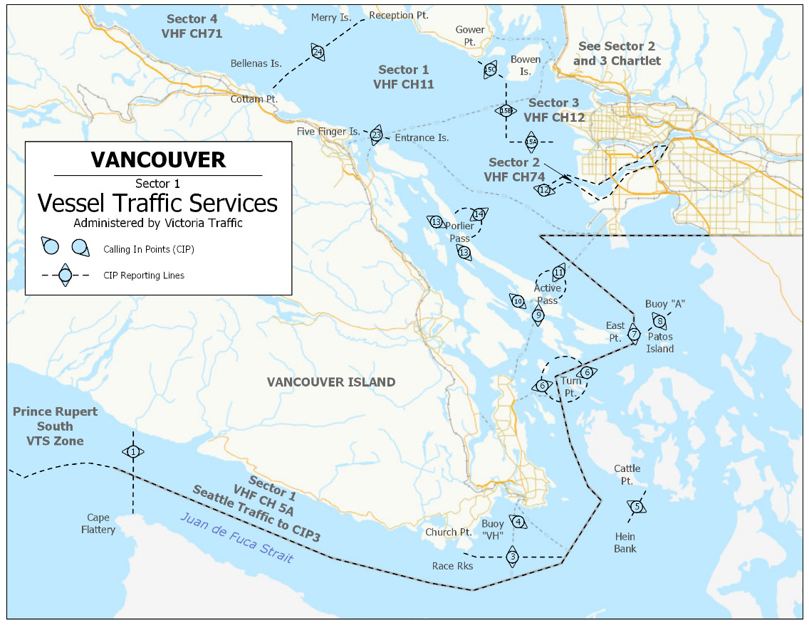
Text description of Figure 3-1 Victoria VTS Zone – Sector 1
The map portrayed in Figure 3-1 is of Sector 1 of the Victoria MCTS VTS Zone as described in detail in the following three tables: Table 3-1, Table 3-2 and Table 3-3.
Figure 3-2 - Victoria VTS Zone – Sectors 2 and 3
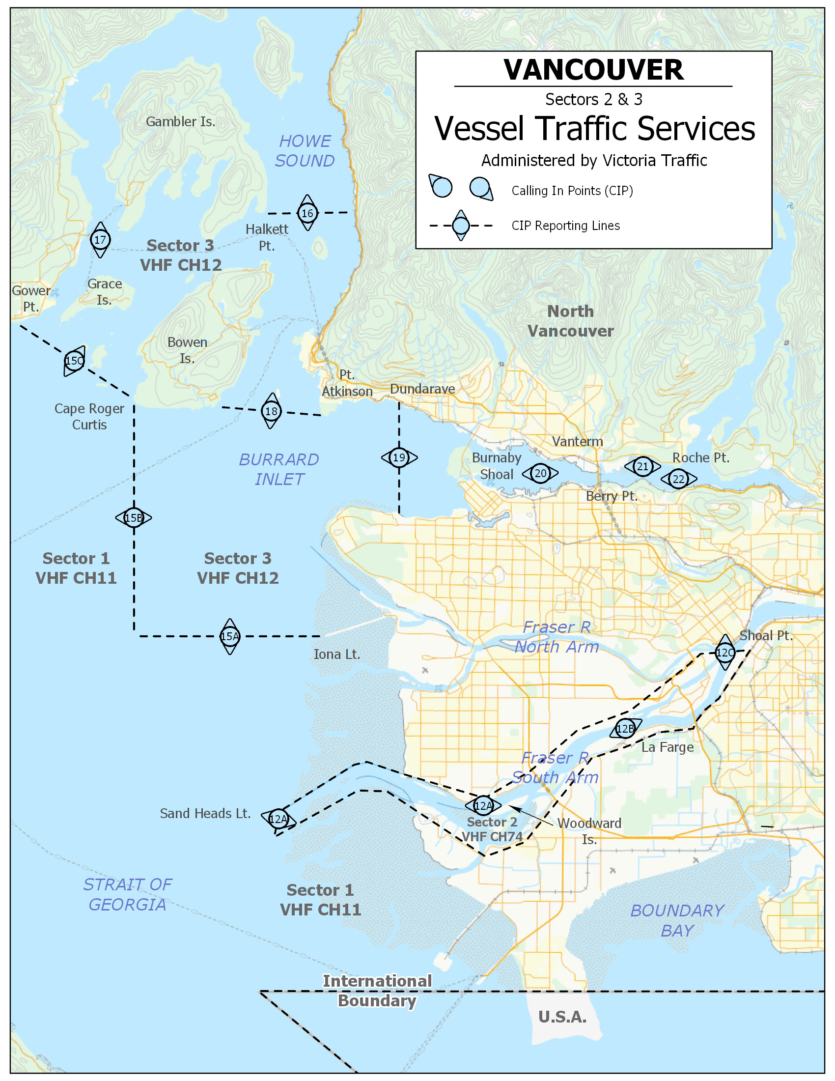
Text description of Figure 3-2 - Victoria VTS Zone – Sectors 2 and 3
The map portrayed in Figure 3-2 is of Sectors 2 and 3 of the Victoria MCTS VTS Zone as described in detail in the following three tables: Table 3-1, Table 3-2 and Table 3-3.
Figure 3-3 - Victoria VTS Zone – Sector 4
Text description of Figure 3-3 Victoria VTS Zone – Sector 4
The map portrayed in Figure 3-3 is of Sector 4 of the Vancouver MCTS VTS Zone as described in detail in the following three tables: Table 3-1, Table 3-2 and Table 3-3.
| Sector | Boundaries |
|---|---|
| 1 | All Canadian waters north of and included within a line from the shoreline of Vancouver Island at 48°34’58”N 124°40’00”W; southward along the meridian of longitude 124°40’00”W, to a point which intersects the International Boundary; thence following the International Boundary eastward and northward through the waters known as the Strait of Juan de Fuca, Haro Strait, Boundary Passage, and the Strait of Georgia to a point which intersects the Canadian shoreline at 49°00’00”N 123°05’20”W; thence to Roberts Bank light 49°05’16”N 123°18’31.5”W; thence to Sandheads light 49°06’23”N 123°18’04”W; thence to the Iona breakwater light 49°12’18”N 123°15’50”W; thence 270° (T) 6.6 nautical miles to 49°12’18”N 123°25 53”W; thence 000° (T) 8.15 nautical miles to Cape Roger Curtis light 49°20’24”N 123°25’53”W; thence 303° (T) 4.8 nautical miles to Gower Point 49°23’01”N 123°32’06”W; thence following the shoreline to a line joining Reception Point light 49°28’15.9”N 123°53’12”W; to Merry Island light 49°28’03.5”N 123°54’40”W; to Ballenas Island light 49°21’02”N 124°09’32”W; to Cottam Point 49°18’57”N 124°12’45”W. |
| 2 | All Canadian waters of the south or main arm of the Fraser River east of the Sandheads light 49°06’23”N 123°18’04”W; to a line running 090° (T) from Shoal Point 49°11’45”N 122°54’51”W, to the opposite south shore. |
| 3 | All Canadian waters contained north and east of a line from the Iona breakwater light, 49°12’18”N 123°15’50”W; thence 270° (T) 6.6 nautical miles to 49°12’18”N 123°25’53”W; thence 000° (T) 8.15 nautical miles to Cape Roger Curtis light 49°20’24”N 123°25’53”W; thence 303° (T) 4.8 nautical miles to Gower Point 49°23’01”N 123°32’06”W; including all the waters of Howe Sound and Burrard Inlet. |
| 4 | All Canadian waters bounded on the south by a line from Reception Point light, 49°28’15.9”N 123°53’12”W; to Merry Island light 49°28’03.5”N 123°54’40”W; to Ballenas Island light 49°21’02”N 124°09’32”W; to Cottam Point 49°18’57”N 124°12’45”W; and bounded on the north by a line from Cape Sutil 50°52'34.23"N 128°3' 7.24"W to Mexicana Point 50° 54'51.96"N 127°59'58.04"W then to Cape Caution 51°09'50"N 127°47'06"W. |
| Sector | Identifier | Channel | Frequency (MHz) |
|---|---|---|---|
| 1 | "Seattle Traffic" (CIP 1, 3, 5, and 8) | 05A | 156.25 |
| 1 | "Victoria Traffic" | 11 | 156.55 |
| 2 | "Victoria Traffic" | 74 | 156.725 |
| 3 | "Victoria Traffic" | 12 | 156.6 |
| 4 | "Victoria Traffic" | 71 | 156.575 |
Note: Seattle and Victoria Traffic Sectors 1, 2 and 3 monitor navigation in the VTS zone using RADAR and AIS. Victoria Traffic Sector 4 monitors navigation in the VTS zone using AIS.
| Number | Sector | Name | General Description and Conditions | Geographic Description |
|---|---|---|---|---|
| 1 | Change | Zone Limit |
A line running north along the meridian 124 40 00W from the International Boundary to the Vancouver Island shoreline. Administered by Seattle and |
A line running north from 48°28’36”N 124°40’00”W to 48°34’58”N 124°40’00”W. |
| 3 | Change | Race Rocks |
A line running 090° -270° (True) through Race Rocks light. Administered by Seattle and |
A line running 090°-270° (T) through 48°17’54”N 123°31’54”W. |
| 4 | 1 | Buoy "VH" |
A line running 000° -180° (True) through buoy "VH". |
A line running 000°-180° (T) through 48°22’32”N 123°23’29”W. |
| 5 | Change | Hein Bank |
A line joining Hein Bank with Cattle Point light, San Juan Island. Administered by Seattle and |
A line running from: 48°22’00”N 123°02’01”W to 48°27’03”N 122°57’45”W. |
| 6 | 1 | Turn Point |
3 NM before reaching |
A circle centered on 48°41’20”N 123°14’10”W, Radius 3 nautical miles. |
| 7 | 1 | East Point |
A line joining East Point light, Mariners are encouraged to call 3 NM from East Point light when entering or exiting Boundary Pass. |
A line running from: 48°47’00”N 123°02’42”W to 48°47’24”N 122°58’13”W. |
| 8 | Change | Patos Island |
A line joining, Patos Island light with Alden Bank light and gong buoy "A". Administered by Seattle and |
A line running from: 48°47’24”N 122°58’13”W to 48°50’24”N 122°52’32”W. |
| 9 | 1 | At Portlock Point |
At Portlock Point. |
A line running 090°-270° (T) through 48°49’41”N 123°21’02”W. |
| 10 | 1 | Peile Point |
At Peile Point light. |
A line running 045°-225° (T) through 48°51’00”N 123°24’14”W. |
| 11 | 1 | Active Pass |
Approaching from the Strait of Georgia, 3 NM Northeast of Entering Strait of Georgia when clear of Active Pass. |
An arc centered on 48°52’24.5”N 123°17’24.5”W Radius 3 nautical miles. |
| 12 | Change | Sandheads |
At Sandheads light. |
A line running 000°-180° (T) through 49°06’23”N 123°18’04”W. |
| 12A | 2 | Woodward Island |
At Woodward Island light at |
A line running 000°-180° (T) through 49°06’23.5”N 123°07’29.5”W. |
| 12B | 2 | La Farge |
At La Farge Cement Plant. |
A line running 157°-337° (T) through 49°09’16.5”N 123°00’15”W. |
| 12C | Change | Shoal Point Zone Limit |
At Shoal Point. Limit of Sector 2 – Victoria Traffic. |
A line running 090°-270° (T) through 49°11’45”N 122°54’51”W. |
| 13 | 1 | West Porlier Pass |
3 NM before entry to or after exit from Porlier Pass. |
An arc centered on Virago Rock Sector light LL 289.3, 49°00’46.5”N 123°35’29.5”W, Radius 3 nautical miles on a line of bearing from seaward 350°-130° (T). |
| 14 | 1 | East Porlier Pass |
3 NM before entry to or after exit from Porlier Pass. |
An arc centered on Virago Rock Sector light LL 289.3, 49°00’46.5”N 123°35’29.5”W, Radius 3 nautical miles on a line of bearing from seaward 180°-265° (T). |
| 15A | Change | Iona |
A line due west of the |
A line running from: 49°12’18”N 123°15’50”W, to 49°12’18”N 123°25’53”W. |
| 15B | Change | Cape Roger Curtis |
A line due south of Cape Roger Curtis intersecting with |
A line running from: 49°12’18”N 123°25’53”W to 49°20’24”N 123°25’53”W. |
| 15C | Change | Gower Point |
A line joining Cape Roger Curtis and Gower Point. |
A line running from: 49°20’24”N 123°25’53”W to 49°23’01”N 123°32’06”W. |
| 16 | 3 | Halkett Point |
A line joining Halkett Point |
A line running 090°-270° (T) from 49°26’43”N 123°19’12”W, to the mainland shoreline. |
| 17 | 3 | Grace Island |
A line joining Grace Island light and the mainland at a point south of Langdale. |
A line running 090°-270° (T) from 49°25’50”N 123°26’48”W, to the mainland shoreline. |
| 18 | 3 | Cowan Point Point Atkinson |
A line joining Cowan Point light on Bowen Island with Point Atkinson light on the mainland. |
A line running from: 49°20’08.5”N 123°21’34.5”W to 49°19’50”N 123°15’48”W. |
| 19 | 3 | Dundarave |
2 NM west of Lions Gate Bridge. Eastbound only report. |
A line running 000°-180° (T) through buoy "QB" 49°19’02.5”N 123°12’00”W. |
| 20 | 3 | Vanterm |
A line joining the west end of Vancouver Ocean Terminals with the east end of Burrard Yarrows Corporation Dry Dock. Outbound vessel traffic will be given First Narrows advisory at Vanterm (CIP 20). Vessel traffic departing west of Outbound vessels broadcast position at Burnaby Shoal. An updated traffic advisory will be given as required. |
A line running 358°-178° (T) from 49°17’23”N 123°04’33”W to 49°18’21”N 123°04’37”W. |
| 21 | 3 | Berry Point |
A line running 000° -180° (True) from Berry Point light to intersect the opposite north shoreline. Westbound only report. |
A line running 000°-180° (T) from 49°17’43”N 122°59’09”W. |
| 22 | 3 | Roche Point |
At Roche Point light. |
A line running 000°-180° (T) through 49°18’02.5”N 122°57’17”W. |
| 23 | 1 | Entrance Island Five Fingers Island |
A line joining Entrance Island light and Five Fingers Island. |
A line running from: 49°12’34”N 123°48’25”W to 49°13’53”N 123°54’52”W. |
| 24 | Change | Ballenas Island Merry Island Welcome Passage |
A line joining Ballenas Island light When northbound, mariners shall indicate whether their route is through Malaspina Strait via Epsom Pt or Welcome Passage, Sabine Channel, Stevens Passage, West of Sisters Island or Ballenas Channel. |
A line running from: 49°28’15.9”N 123°53’12”W to 49°28’03.5”N 123°54’40”W to 49°21’02”N 124°09’32”W to 49°18’57”N 124°12’45”W. |
| 25 | 4 | Cape Lazo Powell River |
A line joining Cape Lazo light and Powell River Breakwater South Entrance South light. When southbound, mariners shall indicate whether their route is through Malaspina Strait via Epsom Pt or Welcome Passage, Sabine Channel, Stevens Passage, West of Sisters Island or Ballenas Channel. |
A line running from: 49°42’24.5”N 124°51’41.5”W to 49°51’36.9”N 124°33’05.7”W. |
| 26 | 4 | Cape Mudge |
At Cape Mudge light. If northbound, mariners shall |
A line running 090°-270° (T) through 49°59’56”N 125°11’38”W. |
| 27 | 4 | Steep Island |
At Steep Island light. If northbound, mariners shall report ETA for Separation Head and update Maud Island light ETA if any change. |
A line running 050°-230° (T) through 50°04’45”N 125°15’06”W. |
| 28 | 4 | Separation Head |
At Separation Head. If southbound, mariners shall report ETA for Steep Island and update Maud Island light ETA if any change. |
A line running 090°-270° (T) through 50°10’51”N 125°21’02”W. |
| 29 | 4 | Cinque Island |
At Cinque Island light. If southbound, mariners shall |
A line running 090°-270° (T) through 50°17’44”N 125°23’59.5”W. |
| 30 | 4 | Ripple Point |
Ripple Point light. |
A line running 000°-180° (T) through 50°22’05”N 125°34’42”W. |
| 31 | 4 | Vansittart Point |
Vansittart Point light. |
A line running 000°-180° (T) through 50°22’37”N 125°44’31”W. |
| 32 | 4 | Fanny Island |
Fanny Island light. |
A line running 045°-225° (T) through 50°27’13”N 125°59’30”W. |
| 33 | 4 | Boat Bay |
Boat Bay light. |
A line running 000°-180° (T) through 50°31’11”N 126°34’37”W. |
| 34 | 4 | Lizard Point |
Lizard Point light. When northbound at Lizard Point, mariners shall indicate whether their route is through Goletas Channel, Gordon Channel, Ripple Passage or Richards Channel. |
A line running 045°-225° (T) through 50°40’17.5”N 126°53’36”W. |
| 35 | 4 | Lewis Point |
Lewis Point light. |
A line running 000°-180° (T) through 50°33’07”N 126°51’10”W. |
| 36 | 4 | Pulteney Point |
3 NM north of Pulteney Point light. When southbound, call 3 NM before Pulteney Point light. When northbound, call at Pulteney Point light, mariners shall indicate whether their route is through Goletas Channel, Gordon Channel, Ripple Passage or Richards Channel. |
An arc centered on 50°37’51”N 127°09’12”W, Radius 3 nautical miles. |
| 37 | 4 | Doyle Island |
Doyle Island light. |
A line running 045°-225° (T) through 50°48’20”N 127°27’32”W. |
| 38 | 4 | Pine Island |
Pine Island light. |
A line running 045°-225° (T) through 50°58’33”N 127°43’35”W. |
| 39 | Change | Cape Caution Cape Sutil |
A line from Cape Caution light to Mexicana Point thence to Cape Sutil. When southbound at Cape Caution, mariners shall indicate whether their route is through Scott Channel, Goletas Channel (Nahwitti Bar), Gordon Channel (Pine Island), |
A line running from: 51°09'50"N 127°47'06"W to 50°54' 51.96"N 127°59'58.04"W to 50°52'34.23"N 128°3'7.24"W. |
All times shall be given in UTC, unless transiting only in one Time Zone. Victoria VTS Zone operates in Pacific Time (PT).
3.5.3.2 Prince Rupert VTS Zone
Figure 3-4 - Prince Rupert VTS Zone – North – Sector 1
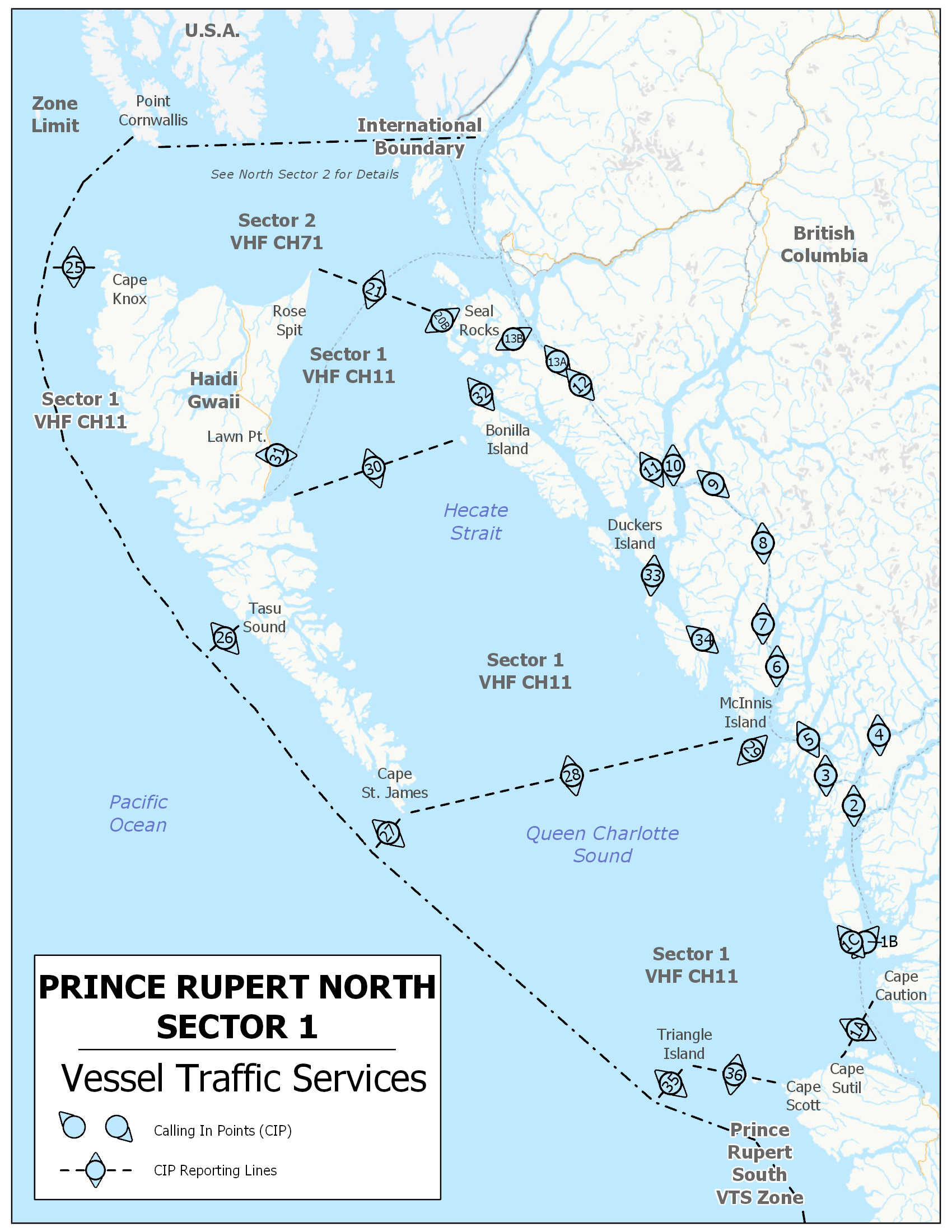
Text description of Figure 3-4 Prince Rupert VTS Zone – North – Sector 1
The map portrayed in Figure 3-4 is of Sector 1 of the Prince Rupert North MCTS VTS Zone as described in detail in the following three tables: Table 3-4, Table 3-5 and Table 3-6.
Figure 3-5 - Prince Rupert – VTS North – Sector 2
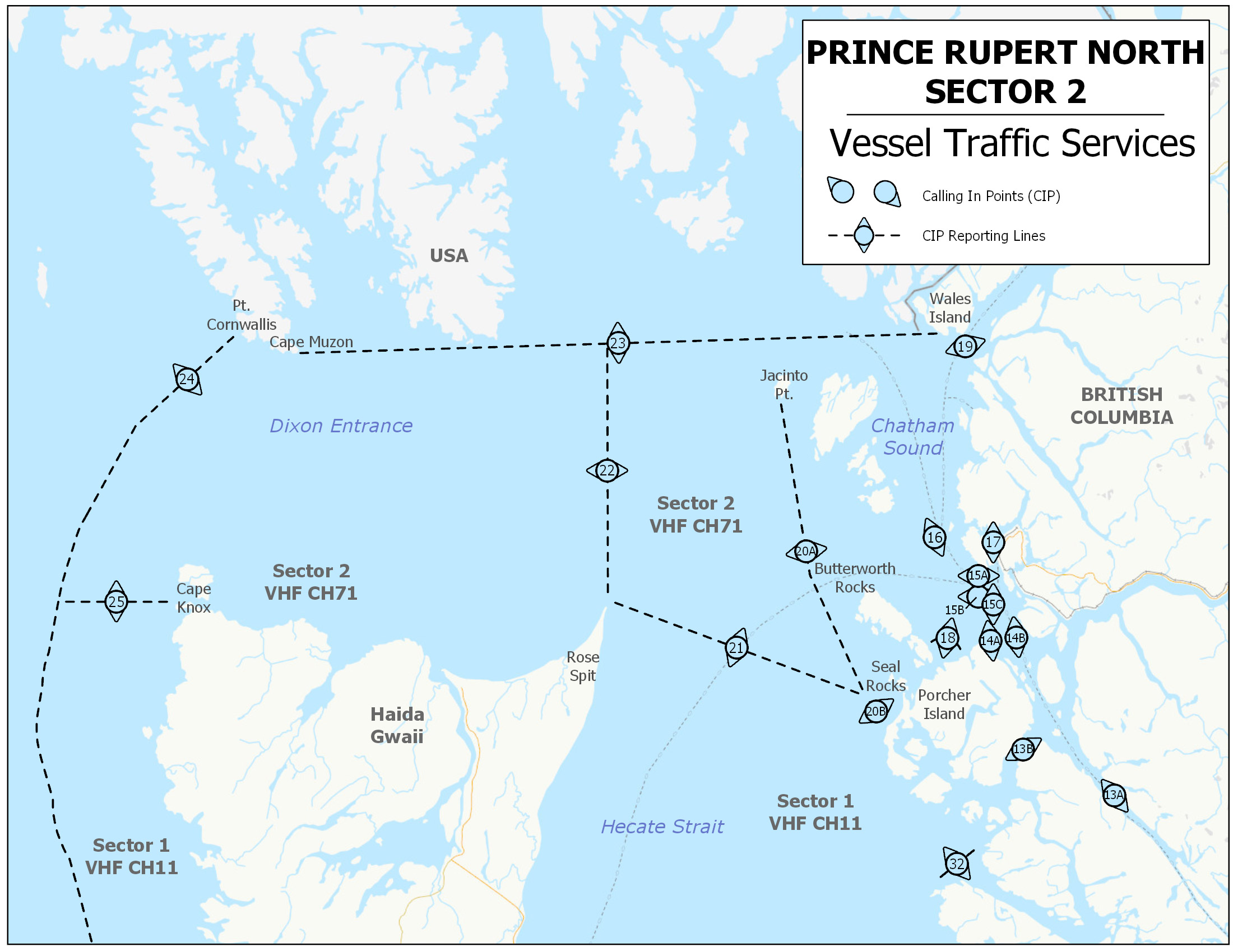
Text description of Figure 3-5 - Prince Rupert – VTS North – Sector 2
The map portrayed in Figure 3-5 is of Sector 2 of the Prince Rupert North MCTS VTS Zone as described in detail in the following three tables: Table 3-4, Table 3-5 and Table 3-6.
| Sector | Boundaries |
|---|---|
| 1 | All Canadian waters north of Vancouver Island from a line joining Cape Caution light 51°09’50”N 127°47’06”W; to Mexicana Point 50°54'51.96"N 127°59'58.04"W thence to Cape Sutil 50°52'34.23"N 128°3'7.24"W. Then following the northwestern shore line to Cape Scott thence; a line extending 281° (T) from 50°46’57”N 128°25’32”W to 50°52’00”N 129°05’00”W following a line 220° (T) to the limit of the Territorial Sea; and thence northward following the limit of the Territorial Sea to a point at 54°11’00”N 133°23’00”W, thence 090° (T) eastward to Cape Knox on Graham Island 54°11’00”N 133°05’00”W to the limit of the Territorial Sea, but not including those waters described in Sector 2 or mainland inlets and channels outside VHF coverage. |
| 2 | All Canadian waters bounded by a line running from Bareside Point 53°54’12”N 130°16’31”W; to Swede Point 53°53’16”N 130°15’35”W. Then following the northern shoreline of Pitt Island to a position of 53°48’03”N 129°58’31”W; thence to a position of 53°48’41.4”N 129°57’07.9”W; thence northward following the mainland shore to a position of 54°09’38”N 129°57’37”W; thence to a position of 54°11’53”N 129°58’51”W; thence northward following the mainland shore to 54°37’57”N 130°26’31”W; thence to a position of 54°38’02”N 130°26’31”W; thence northward along the west shore of Maskelyne Island to Maskelyne Point 54°38’55”N 130°26’488”W; thence to Wales Point 54°42’17”N 130°28’42”W; thence westward along the shore of Wales Island to 54°42’06”N 130°31’47”W; thence to a position of 54°42’25”N 130°36’55”W; thence westward along the International Boundary to Cape Muzon light 54°39’48”N 132°41’30”W; thence southwestward to a point at 54°20’00”N 133°22'00”W thence following the limit of the territorial sea tsouthward to a point at 54°11’00”N 133°23’00”W; thence 090° (T) eastward to Cape Knox on Graham Island 54°11’00”N 133°05’00”W; thence eastward along Graham Island shoreline to Rose Spit 54°11’12.5”N 131°38’43”W; thence southeastward to Seal Rocks 54°00’00”N 130°47’26”W; thence to Oval Point on Porcher Island 53°56’24”N 130°43’15”W, thence eastward following Porcher Island shoreline to Bareside Point. |
| Sector | Identifier | Channel | Frequency (MHz) |
|---|---|---|---|
| 1 | "Prince Rupert Traffic" | 11 | 156.55 |
| 2 | "Prince Rupert Traffic" | 71 | 156.575 |
Note: Prince Rupert Traffic monitors navigation in the VTS zone using RADAR and AIS.
| Number | Sector | Name | General Description and Conditions | Geographic Description |
|---|---|---|---|---|
| 1A | Change | Cape Caution Cape Sutil |
A line from Cape Caution light to Mexicana Point thence to Cape Sutil. |
A line running from: 51°09'50"N 127°47'06"W to 50°54'51.96"N 127°59'58.04"W to 50°52'34.23"N 128°3' 7.24"W. |
| 1B | 1 | Dugout Rocks |
A line joining Dugout Rocks light with Cape Calvert. Mariners bound for Fitz Hugh Sound shall report ETA Dugout Rocks. |
A line running from: 51°22’01.5”N 127°48’23.5”W to 51°25’04”N 127°54’16”W. |
| 1C | 1 | Pearl Rocks |
A line joining Pearl Rocks with the southern most of the Sorrow Islands and thence Cape Calvert. Mariners bound for Queen Charlotte Sound via North Passage shall report ETA Pearl Rocks. |
A line running from: 51°22’00”N 128°00’12”W to 51°24’33”N 127°55’18”W; thence 51°25’04”N 127°54’16”W. |
| 2 | 1 | Fog Rocks |
Fog Rocks light. |
A line running 090°-270° (T) through 51°58’21”N 127°55’02”W. |
| 3 | 1 | Walker Island |
Walker Island light Lama Passage. |
A line running 090°-270° (T) through 52°05’58”N 128°06’55”W. |
| 4 | 1 | Barba Point |
A line joining Barba Point and |
A line running from: 52°16’11”N 127°44’55”W to 52°16’06”N 127°47’00”W. |
| 5 | 1 | Idol Point |
A line joining Idol Point light to |
A line running from: 52°14’19”N 128°16’31”W to 52°15’27”N 128°13’19”W. |
| 6 | 1 | Freeman Point |
Freeman Point light. If northbound, mariners shall report ETA Boat Bluff light and Ditmars Point. Mariners shall advise if intending to transit Hiekish Narrows. |
A line running 090°-270° (T) through 52°33’11.5”N 128°29’18”W. |
| 7 | 1 | Ditmars Point |
Ditmars Point. If southbound, mariners shall report ETA Boat Bluff light and Freeman Point. |
A line running 090°-270° (T) through 52°43’48”N 128°34’12”W. |
| 8 | 1 | Griffin Point |
Griffin Point light. If southbound, mariners shall advise if intending to transit Hiekish Narrows. |
A line running 090°-270° (T) through 53°03’56”N 128°32’54”W. |
| 9 | 1 | Kingcome Point |
A line joining Kingcome Point light and Angler Cove. |
A line running from: 53°17’57”N 128°54’23”W to 53°18’44”N 128°53’17”W. |
| 10 | 1 | Money Point |
Money Point light. Mariners bound for Kitimat shall report an ETA for Emilia Island light. |
A line running 090°-270° (T) through 53°22’55”N 129°09’50”W. |
| 11 | 1 | Sainty Point |
A line joining Sainty Point light and If northbound, mariners shall report |
A line running from: 53°22’18”N 129°18’40”W to 53°21’47”N 129°20’00”W. |
| 12 | 1 | Pitt Island light |
Pitt Island light. If southbound, mariners shall report |
A line running 045 -225° (T) through 53°42’00”N 129°48’38”W. |
| 13A | Change | Baker Inlet |
A line across Grenville Channel from Baker Inlet light. |
A line running 052°-232° (T) through 53°48’41.4”N 129°57’07.9”W. |
| 13B | Change | Swede Point |
A line across Ogden Channel joining Bareside Point and Swede Point. |
A line joining 53°54’12”N 130°16’31”W and 53°53’16”N 130°15’35”W. |
| 14A | 2 | Lawyer Islands |
A line joining Hunt Point and |
A line joining 54°06’11”N 130°24’54”W; to 54°06’36”N 130°20’12”W. |
| 14B | 2 | Genn Islands |
A line joining Lawyer Islands and |
A line joining 54°06’36”N 130°20’12”W to 54°07’03”N 130°14’39”W. |
| 15A | 2 | Petrel Rock |
A line from Digby Island to |
A line running 180° (T) from 54°15’33”N 130°25’00”W to 54°12’30”N 130°25’00”W. |
| 15B | 2 | Greentop Islet |
A line from West Kinahan Island to a position near Greentop Islet. |
A line running from: 54°12’30”N 130°25’00”W; to 54°10’40”N 130°25’00”W. |
| 15C | 2 | Holland Rock |
A line from a position near |
A line running from: 54°10’40”N 130°25’00”W to 54°10’40”N 130°19’00”W. |
| 16 | 2 | Lucy Islands |
A line from Lucy Islands light to |
A line running from: 54°17’46”N 130°36’25”W to 54°19’10”N 130°30’54”W. |
| 17 | 2 | Pillsbury Point |
A line joining Pillsbury Point and |
A line running from: 54°17’58”N 130°21’05”W to 54°17’58”N 130°22’55”W. |
| 18 | 2 | Edye Passage |
A 3 NM arc centered on Table Point. Mariners are encouraged to call at |
An arc centered on 54°03’49”N 130°31’55”W; Radius 3 nautical miles bearing from seaward 137°-233° (T). |
| 19 | 2 | Wales Point |
A line joining Wales Point to |
A line running from: 54°42’17”N 130°28’33”W to 54°38’55”N 130°26’42”W. |
| 20A | 2 | Butterworth Rocks |
A line from Jacinto Point light to Butterworth Rocks light thence to Mariners shall report routing if not using Brown Passage. |
A line running from: 54°34’47”N 131°04’30”W to 54°14’08”N 130°58’30”W, thence 54°00’00”N 130°47’26”W. |
| 20B | Change | Seal Rocks |
A line joining Seal Rocks light to |
A line running from: 54°00’00”N 130°47’26”W to 53°56’24”N 130°43’15”W. |
| 21 | Change | Rose Spit Seal Rocks |
A line joining Rose Spit with |
A line running from: 54°11’12.5”N 131°38’43”W to 54°00’00”N 130°47’26”W. |
| 22 | 2 | Rose Spit |
A line extending 000° (True) from |
A line running 000° (T) from 54°11’12.5”N 131°38’43”W to the International Boundary. |
| 23 | 2 | International Boundary Dixon Entrance |
A line following the International Boundary between Alaska, USA and British Columbia, Canada between Cape Muzon light and Wales Island. Mariners shall report whether their route is through Holliday Passage, Oriflamme Passage or Main Passage when transiting Chatham Sound. |
A line running from: 54°39’48”N 132°41’30”W to 54°42’25”N 130°36’55”W. |
| 24 | 2 | Zone Limit |
A line running from Cape Muzon light extending on a southwestward arc following the limit of the Territorial Sea to 54°11’00”N 133°28’34.6”W. |
A line running from: 54°39’48”N 132°41’30”W to 54°20’00”N 133°22’00”W to 54°11’00”N 133°23’00”W along the limit of the Territorial Sea. |
| 25 | Change | Cape Knox |
A line extending 270° (True) from Cape Knox to the limit of the Territorial Sea. |
A line running 270° (T) from 54°11’00”N 133°05’00”W; to the limit of the Territorial Sea. |
| 26 | 1 | Tasu Sound |
A line extending 220° (True) from Davidson Point light to the limit of the Territorial Sea Mariners shall report |
A line running 220° (T) from 52°44’32”N 132°06’42”W to the limit of the Territorial Sea. |
| 27 | 1 | Cape St. James |
A line extending 220° (True) from |
A line running 220° (T) from 51°56’10”N 131°00’52”W to the limit of the Territorial Sea. |
| 28 | 1 | McInnes Island Cape St. James |
A line joining McInnes Island light and Cape St. James light. |
A line running from: 52°15’42”N 128°43’13”W to 51°56’10”N 131°00’52”W. |
| 29 | 1 | Cape Mark McInnes Island |
A line from Cape Mark light to |
A line running from: 52°08’59”N 128°32’18”W to 52°15’42”N 128°43’13”W. |
| 30 | 1 | Bonilla Island Sandspit |
A line joining Bonilla Island sector light and Sandspit aeronautical beacon. |
A line running from: 53°29’34”N 130°38’09”W to 53°15’03”N 131°48’50”W. |
| 31 | 1 | Lawn Point |
A 3 NM arc centered on Lawn Point. |
An arc centered on 53°25’29.7”N 131°54’50.2”W; Radius 3 nautical miles, bearing from seaward 180°-000° (T). |
| 32 | 1 | White Rocks |
A line joining Browning Entrance light to Hankin Rock light. |
A line running from: 53°38’05”N 130°33’48”W to 53°42’28”N 130°24’36”W. |
| 33 | 1 | Duckers Islands |
A line joining Duckers Islands light to Dupont Island light. If northbound, mariners shall report whether route is through Squally Channel or Whale Channel. |
A line running from: 52°55’31.4”N 129°11’28.5”W to 52°56’23.3”N 129°26’10.2”W. |
| 34 | 1 | Wilson Rock |
A line across Laredo Channel through Wilson Rock. |
A line running 232 -052° (T) through 52°40’00”N 128°57’55”W. |
| 35 | Change | Triangle Island |
A line extending 220° (True) from Triangle Island to the limit of the Territorial Sea. |
A line running 220° (T) from 50°52’00”N 129°05’00”W to 50°42’11”N 129°18’00”W. |
| 36 | Change | Cape Scott |
A line joining Cape Scott light with Triangle Island. |
A line running from: 50°46’57”N 128°25’32”W to 50°52’00”N 129°05’00”W |
All times shall be given in UTC, unless transiting only in one Time Zone. Prince Rupert VTS Zone operates in Pacific Time (PT).
Figure 3-6 - Prince Rupert VTS Zone – South – Sector 1
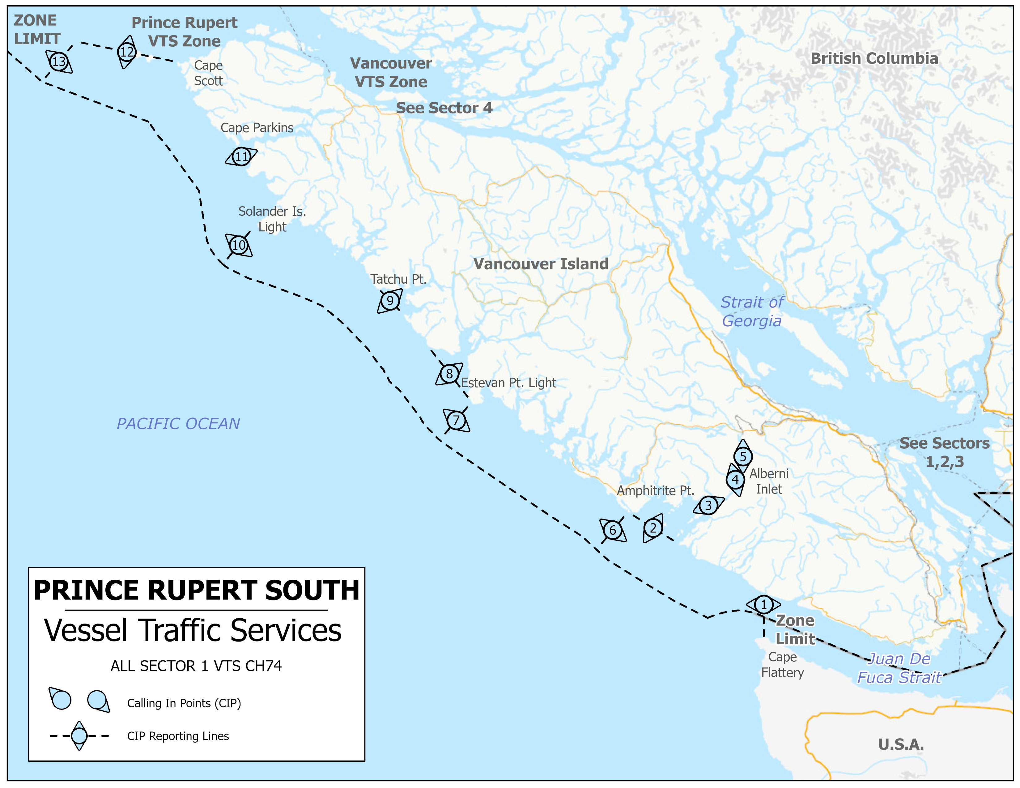
Text description of Figure 3-6 - Prince Rupert VTS Zone – South – Sector 1
The map portrayed in Figure 3-6 is of the Prince Rupert South MCTS VTS Zone as described in detail in the following three tables: Table 3-7, Table 3-8 and Table 3-9.
| Sector | Boundaries |
|---|---|
| 1 | All Canadian waters bounded by a line drawn from the International Boundary at 48°28′36″ N, 124°40′00″ W northward following the territorial sea limit to a point at 50°42’11”N 129°18’00”W; thence following a line 040° (T) to Triangle Island 50°52’00”N 129°05’00”W to Cape Scott 50°46’57”N 128°25’32”W; thence following the shoreline to 50°40′15″ N,128°21′40″ W to 50°38′18.2″ N, 128°19′40″ W; thence following the shoreline to 50°26′38″ N, 128°02′43.5″ W to 50°19′28″ N, 127°58′30″ W to 50°13′14″ N, 127°47′54″ W; thence following the shoreline to 50°07′49.45″ N, 127°42′35.77″ W to 49°59′49″ N, 127°27′06.5″ W to 49°51′35″ N, 127°09′00″ W to 49°44′57″ N, 126°58′54″ W to 49°37′09.13″ N, 126°49′33″ W to Estevan Point (49°23′00″ N, 126°32′34″ W) to 49°17′03″ N, 126°13′44″ W to 49°05′22″ N, 125°52′55″ W; thence following the shoreline to 49°01′54″ N, 125°19′26.5″ W to 48°58′10.3″ N, 125°19′21.7″ W; thence following the shoreline to 48°58′45.35″ N, 125°11′01.67″ W to 48°57′24.5″ N, 125°01′50″ W to 48°59′03.5″ N, 124°57′44.65″ W; thence following the shoreline to Port Alberni (49°14′01″ N, 124°48′38″ W); thence following the shoreline to Cape Beale (48°47′11″ N, 125°12′58″ W) to Pachena Point (48°43′20″ N, 125°05′51″ W); thence following the shoreline to 48°40′11.5″ N, 124°51′29″ W to 48°40′00″ N, 124°51′00″ W; thence following the shoreline to 48°34′58″ N, 124°40′00″ W; thence southerly to intersect the international border at 48°28′36″ N, 124°40′00″ W. |
| Sector | Identifier | Channel | Frequency (MHz) |
|---|---|---|---|
| 1 | "Prince Rupert Traffic" | 74 | 156.725 |
Note: Prince Rupert Traffic monitors navigation in the VTS zone using RADAR and AIS.
| Number | Sector | Name | General Description and Conditions | Geographic Description |
|---|---|---|---|---|
| 1 | 1 | Zone Limit | A line running north along the meridian 124°40'00"W from the International Boundary to the Vancouver Island shoreline. Administered by Seattle and Prince Rupert Traffic (CVTS). |
- |
| 2 | 1 | Cape Beale | A line joining Cape Beale light with Amphitrite Point light. Mariners shall indicate whether their course is through Trevor Channel, Imperial Eagle Channel or Loudoun Channel. |
A line joining: 48°47’13”N 125°12’51”W to 48°55’17”N 125°32’23”W. |
| 3 | 1 | Chup Point | A line joining Chup Point with Mutine Point. |
A line joining: 48°57’20”N 125°01’37”W to 48°56’33”N 125°01’06”W. |
| 4 | 1 | Ten Mile Point | A line extending 256° (True) from Ten Mile Point light to the opposite shore of Alberni Inlet. |
A line extending 256° (T) from 49°03’34”N 124°50’22”W to 49°03’20.5”N 124°51’44”W. |
| 5 | 1 | Dunsmuir Point | A line extending 090° (True) from Dunsmuir Point light to the opposite shore of Alberni Inlet. |
A line extending 090° (T) from 49°09’16”N 124°48’26”W to 49°09’16”N 124°47’42”W. |
| 6 | 1 | Amphitrite Point | A line extending 220° (True) from Amphitrite Point light to the limit of the Territorial Sea. |
A line extending 220° (T) from 48°55’17”N 125°32’23”W to 48°46’06”N 125°44’02”W. |
| 7 | 1 | Estevan Point | A line extending 220° (True) from Estevan Point light to the limit of the Territorial Sea. |
A line extending 220° (T) from 49°23’00”N 126°32‘32”W to 49°13’47”N 126°44’25.5”W. |
| 8 | 1 | Nootka Sound | A line joining Estevan Point light and Bajo Point. |
A line joining: 49°23’00”N 126°32’32”W to 49°37’06”N 126°49’35”W. |
| 9 | 1 | Esperanza Inlet | A line joining Ferrer Point and Tatchu Point. |
A line joining: 49°44’57”N 126°58’54”W to 49°51’35”N 127°08’56”W. |
| 10 | 1 | Solander Island | A line extending 220° (True) from Solander Island light to the limit of the Territorial Sea. |
A line extending 220° (T) from 50°06’40.5”N 127°56’17”W to 49°57’26”N 128°08’16”W. |
| 11 | 1 | Kains Island (Quatsino Sound) | A line joining Kwakiutl Point and Cape Parkins. |
A line joining: 50°21’09”N 127°59’27.5”W to 50°26’38”N 128°02’43.5”W. |
| 12 | 1 | Cape Scott Triangle Island | A line extending 281° (True) from Cape Scott light, passing through Cox and Lanz Islands to Triangle Island. |
A line extending 281° (T) from 50°46’57”N 128°25’32”W to 50°52’00”N 129°05’00”W. |
| 13 | 1 | Zone Limit | A line extending 220° (True) from Triangle Island to the limit of the Territorial Sea. |
A line extending 220° (T) from 50°52’00”N 129°05’00”W to 50°42’11”N 129°18’00”W. |
All times shall be given in UTC, unless transiting only in one Time Zone. Prince Rupert VTS Zone operates in Pacific Time (PT).
3.5.4 Co-Operative Vessel Traffic Services (CVTS) Agreement
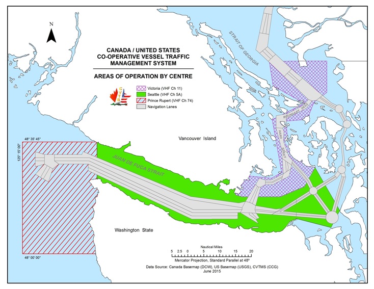
Figure 3-7 - Canada/United States Co-operative Vessel Traffic Management System
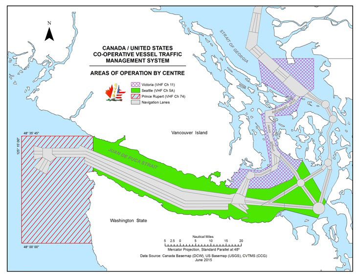
Text description of Figure 3-7 - Canada/United States Co-operative Vessel Traffic Management System
The map entitled “Canada / United States Co-operative Vessel Traffic Management System” describes the area of operation by centre for Victoria, Seattle, Prince Rupert.
In 1979, by formal agreement, the Canadian Coast Guard and the United States Coast Guard established the Co-operative Vessel Traffic Services (CVTS) for the Strait of Juan de Fuca region. The purpose of this agreement is to provide for a co-operative system of vessel traffic management in the applicable waters in order to enhance safe and expeditious movement of vessel traffic while minimizing the risk of pollution of the marine environment.
Participation with Prince Rupert, Seattle and Victoria Traffic is mandatory within Canadian and United States territorial waters. The CVTS Area of Operation is defined as 124°40W south along the Washington coast to 48°00N then west to 125°15W and north to 48°35’45”N. Inbound vessels are to check in with Prince Rupert Traffic on VHF Channel 74 (156.725 MHz) at either 48°00N or 125°15W prior to entering the traffic separation scheme. An information service such as a vessel’s identity, destination, or other information obtained through the VTS reports and sensors, is available upon request outside of the VTS zone.
3.5.4.1 West Coast Approaches to Juan de Fuca Strait – Prince Rupert Traffic
Vessel Traffic Services from 124°40’00W in Juan de Fuca Strait westward to 125°15’00”W, and intersecting to the south to 48°00N from the west coast of Washington State are provided by the CCG from the Prince Rupert MCTS Centre located in Prince Rupert, B.C.
All communications with vessels in these areas will be conducted on VHF Ch74 (156.725 MHz).
3.5.4.2 Juan de Fuca Strait – Seattle Traffic
Vessel Traffic Services in the area containing all Canadian and United States waters from 124°40’00’’W which intersects the Canadian and United States shorelines thence easterly through the Juan de Fuca Strait, including all waters south and east of a line from Church Point to Race Rocks light to the intersection of the Canada/United States International boundary to Hein Bank light and bell buoy to Cattle Point, and south of a line from Patos Island to Alden Bank lighted gong buoy "A" and north to the 49th parallel, including the United States Gulf Island waters are provided by the United States Coast Guard from the Puget Sound VTS Center located in Seattle, WA (Seattle Traffic).
All communications with vessels in these areas will be conducted on VHF Ch05A (156.250 MHz).
3.5.4.3 Haro Strait and Approaches, Boundary Pass, South Portion Strait of Georgia – Victoria Traffic
Vessel Traffic Services in the area containing all Canadian and United States waters north and east of a line from Church Point to Race Rocks light to the intersection of the Canada/United States International boundary to Hein Bank light and bell buoy to Cattle Point including all of Haro Strait, Boundary Passage and the southern portion of the Strait of Georgia are provided by the Canadian Coast Guard from MCTS Victoria at Patricia Bay, B.C. (Victoria Traffic).
All communications with vessels in these areas will be conducted on VHF Ch11 (156.55 MHz).
3.6 Eastern VTS Zone Reporting Requirements

Text description of Figure: Eastern Canada Vessel Traffic Services VTS Zones
This map displays the Vessel Traffic Services (VTS zones) of Eastern Canada. Highlighted in blue are the waters which fall under the Eastern VTS Zone regulations. Various sized rectangular shapes indicate the local VTS zones.
3.6.1 Application
The VTSZ Regulations (SOR 2025-275) apply exclusively to the following vessels that are about to enter, leave or proceed within a VTS Zone as described in Schedule 2:
- vessels of 300 gross tonnage or more;
- vessels that are engaged in towing or pushing another vessel, if the combined gross tonnage is 500 gross tonnage or more; and,
- vessels that are carrying as cargo a pollutant or dangerous goods, or vessels that are engaged in towing or pushing such a vessel.
3.6.2 Reporting Requirements
3.6.2.1 Sailing Plan (SP) – 24 hour report
- 24 hours if entering a VTS Zone from outside of Canadian waters, or as soon as feasible if the estimated time of arrival of the vessel is less than 24 hours after the time the vessel departed from their last port of call.
- All designators from the Standard VTS Reporting template (Section 3.4 of this publication) that are listed in the Collaborative Vessel Management System form must be answered.
- All time references are to be in Coordinated Universal Time (UTC), unless transiting in only one Time Zone.
- The Collaborative Voyage Management System must be used to obtain and submit the 24 hour report Sailing Plan. If experiencing difficulties, contact:
MCTS Halifax Centre
HLXECAREG1@innav.gc.ca
Telephone: +1-902-426-4956
Standard VTS Reporting template designator-specific detailed reporting requirements:
Designator [P], this includes:
- Any dangerous goods, listed by total amount of each IMO class on board, or pollutant, that is carried on board the vessel or a vessel being towed or pushed by the vessel, including the quantity
Designator [Q], this includes:
- Anything of the vessel or its machinery, equipment or charts and nautical publications, or circumstances that adversely affect normal navigation.
Designator [R], this includes:
- Any discharge, or threat of discharge, of a pollutant from the vessel into the water, and any damage to the vessel that may result in the discharge or a pollutant from the vessel into the water.
Designator [T], this includes:
- In the case of a Canadian vessel, its authorized representative or owner.
- In the case of a foreign vessel, its Canadian or American agent or owner.
Designator [X], this includes:
- the expiration date of the certificate referred to in Article VII of the International Convention on Civil Liability for Oil Pollution Damage, 1969/1992;
- the expiration date of the International Oil Pollution Prevention Certificate;
- the expiration date of the International Pollution Prevention Certificate for the Carriage of Noxious liquid Substances in Bulk;
- the expiration date of the Certificate of Fitness and the Certificate of Compliance;
- the expiration date of the ISM Safety Management Certificate;
- the expiration date of the ISM document of compliance;
- the expiration date of the International Convention on Civil Liability for Bunker Oil Pollution Damage, 2001 Certificate – known as Bunkers Convention Certificate;
- the expiration date of the Certificate of Insurance or Other Financial Security in Respect of Liability for the Removal of Wrecks
3.6.2.2 Sailing Plan (SP) – other
The following outlines the situations to file a SP, the Standard VTS Reporting template (Section 3.4 of this publication) designator-specific reporting requirements, and the filing times. Tables 3-11, 3-14, 3-17, 3-20, 3-23, 3-26, 3-29, 3-32 and 3-35 detail which VHF frequencies can be used in VTS sectors.
3.6.2.2.1 SP – Departing Berth in an Eastern VTS Zone
- More than one hour but not more than two hours before departing from a berth within the Eastern VTS Zone (as described in Schedule 2).
- The SP must include the following designators from the Standard VTS Reporting template:
[A], [B], [C] or [D], [H], [I], [L], [N], [O], [P], [Q], [R], [S] (if needed), [T], [W],
Note: This report is not required when the vessel is moving to another berth in the same port.
Note: Designators [O], [P], [Q], [S], [T], [W], [X] are not required if the corresponding information has not changed since the previous sailing plan report.
Designator [P], this includes:
- Any dangerous goods, listed by total amount of each IMO class on board, or pollutant, that is carried on board the vessel or a vessel being towed or pushed by the vessel, including the quantity
Designator [Q], this includes:
- Anything of the vessel or its machinery, equipment or charts and nautical publications, or circumstances that adversely affect normal navigation.
Designator [R], this includes:
- Any discharge, or threat of discharge, of a pollutant from the vessel into the water, and any damage to the vessel that may result in the discharge or a pollutant from the vessel into the water.
Designator [T], this includes:
- In the case of a Canadian vessel, its authorized representative or owner.
- In the case of a foreign vessel, its Canadian or American agent or owner.
Designator [X], this includes:
- the expiration date of the certificate referred to in Article VII of the International Convention on Civil Liability for Oil Pollution Damage, 1969/1992;
- the expiration date of the International Oil Pollution Prevention Certificate;
- the expiration date of the International Pollution Prevention Certificate for the Carriage of Noxious liquid Substances in Bulk;
- the expiration date of the Certificate of Fitness and the Certificate of Compliance;
- the expiration date of the ISM Safety Management Certificate;
- the expiration date of the ISM document of compliance;
- the expiration date of the International Convention on Civil Liability for Bunker Oil Pollution Damage, 2001 Certificate - known as Bunkers Convention Certificate;
- the expiration date of the Certificate of Insurance or Other Financial Security in Respect of Liability for the Removal of Wrecks.
- For vessels departing from a Québec-based port in the Gulf of St. Lawrence the SP shall be sent to:
MCTS Centre Les Escoumins
Telephone: +1-418-233-3483
Facsimile: +1-418-233-3299
Email: ecareg.escoumins@innav.gc.ca
3.6.2.2.2 SP – Underway following situations described
- Immediately before a vessel gets underway within a VTS zone after the following situations:
- vessel was stranded;
- vessel was stopped as a result of a breakdown in the main propulsion or steering system; or,
- vessel was involved in a collision
- The SP must include the following designators from the Standard VTS Reporting template:
[A], [B], [C] or [D], [I], [L], [N], [O], [P], [Q], [R], [S], [T], [W], [X]
Note: designators [O], [P], [Q], [R], [S], [T], [W], are not required if the information has not changed.
Designator [X], this includes:
- a description of the situation.
3.6.2.3 Position Report (PR)
The following outlines the situations to file a PR, the Standard VTS Reporting template (Section 3.4 of this publication ) designator-specific reporting requirements, and the filing times. Tables 3-11, 3-14, 3-17, 3-20, 3-23, 3-26, 3-29, 3-32, and 3-35 detail which VHF frequencies can be used in VTS sectors.
3.6.2.3.1 PR – Entering Eastern VTS Zone
- Immediately after the vessel enters the Eastern VTS Zone.
- The PR must include the following designators from the Standard VTS Reporting template:
[A], [B], [C] or [D], [E], [F], [H], [I], [N]
Note: This report is not required when entering directly from a Local Eastern VTS Zone.
3.6.2.4 Final Report (FR)
The following outlines the situations to file a FR, the Standard VTS Reporting template (Section 3.4 of this publication) designator-specific reporting requirements, and the filing times. Tables 3-11, 3-14, 3-17, 3-20, 3-23, 3-26, 3-29, 3-32, and 3-35 detail which VHF frequencies can be used in VTS sectors.
3.6.2.4.1 FR – Arrival at berth in Eastern VTS Zone
- On arrival of the vessel at a berth within the VTS Zone.
- The FR must include the following designators from the Standard VTS Reporting template:
[A], [B], [C] or [D], [K]
3.6.2.4.2 FR – Exiting Eastern VTS Zone
- Immediately before the vessel leaves the Eastern VTS Zone.
- The FR must include the following designators from the Standard VTS Reporting template:
[A], [B], [C] or [D], [K]
Note: This report is not required when entering any other VTS Zone.
3.6.2.5 Other Reports
The following outlines the situations to file Other Reports, the Standard VTS Reporting template (Section 3.4 of this publication) designator-specific reporting requirements, and the filing times. Tables 3-11, 3-14, 3-17, 3-20, 3-23, 3-26, 3-29, 3-32, and 3-35 detail which VHF frequencies can be used in VTS sectors.
- As soon as feasible, after the master becomes aware of any of the following, a report must include designators [A], [B], [C] or [D] and [X] from the Standard VTS Reporting template, with [X] containing the details of the situation:
- A fire or explosion on board the vessel;
- The vessel is involved in a collision, a grounding or a striking;
- The vessel makes unforeseen contact with the bottom without running aground;
- There is a defect in the vessel’s hull, main propulsion system, steering system, anchor, and any equipment that is required under the Navigation Safety Regulations, 2020;
- The vessel’s seaworthiness is affected;
- All or part of the vessel’s cargo shifts or falls overboard;
- Another vessel is in apparent difficulty;
- There is an obstruction to navigation;
- An aid to navigation is missing, out of position, malfunctioning, or damaged;
- There are ice or weather conditions that are hazardous to safe navigation;
- A pollutant is in the water;
- The presence of a vessel that may impede the movement of the vessel or any other vessel;
- The following identified risks to the health and well-being of individuals on board the vessel including the crew:
- Category not currently in use
- The following identified risks to marine safety or the marine environment:
- Category not currently in use
3.6.2.6 Deviation Report (DR)
The following outlines the situations to file a DR, the Standard VTS Reporting template (Section 3.4 of this publication) designator-specific reporting requirements, and the filing times. Tables 3-11, 3-14, 3-17, 3-20, 3-23, 3-26, 3-29, 3-32, and 3-35 detail which VHF frequencies can be used in VTS sectors.
- As soon as feasible, after the master becomes aware of any significant changes in any of the information previously reported.
- The DR must include the following designators from the Standard VTS Reporting template:
[A], [B], [C] or [D], and any other designators that have a change of information.
3.7 Local Eastern VTS Zones Reporting Requirements
3.7.1 Application
The VTSZ Regulations (SOR 2025-275)apply to the following vessels that are about to enter, leave or proceed within a VTS Zone as described in Schedule 3:
- vessels of 300 gross tonnage or more;
- vessels that are engaged in towing or pushing another vessel, if the combined gross tonnage is 500 gross tonnage or more; and,
- vessels that are carrying as cargo a pollutant or dangerous goods, or vessels that are engaged in towing or pushing such a vessel.
3.7.1.1 Additional application
Sections 3.7.2.2 to 3.7.2.6 of this publication also apply to the following vessels:
- A vessel that is 20m or more in length, other than,
- a pleasure craft that is less than 30m in length, and
- a fishing vessel that is less than 24m in length and not more than 150 gross tonnage.
- A vessel that is engaged in towing or pushing another vessel or an object, other than fishing gear, unless the vessel and the other vessel or object being towed or pushed are within a log booming ground, if:
- the combined length of the vessel and the other vessel or object is 45m or more, or
- the length of the other vessel or object is 20m or more.
3.7.2 Reporting Requirements
3.7.2.1 Sailing Plan (SP) – 24 hour report (only applies to vessels as described in 3.7.1)
- 24 hours if entering a VTS Zone from outside of Canadian waters, or as soon as feasible if the estimated time of arrival of the vessel is less than 24 hours after the time the vessel departed from their last port of call.
- All designators from the Standard VTS Reporting template (Section 3.4 of this publication) that are listed in the Collaborative Vessel Management System form must be answered.
- All time references are to be in Coordinated Universal Time (UTC), unless transiting only in one Time Zone.
- The Collaborative Voyage Management System must be used to obtain and submit the 24 hour report Sailing plans. If experiencing difficulties, contact:
Halifax MCTS Centre
HLXECAREG1@innav.gc.ca
Telephone: +1-902-426-4956
Standard VTS Reporting template designator-specific detailed reporting requirements:
Designator [P], this includes:
- Any dangerous goods, listed by total amount of each IMO class on board, or pollutant, that is carried on board the vessel or a vessel being towed or pushed by the vessel, including the quantity
Designator [Q], this includes:
- Anything of the vessel or its machinery, equipment or charts and nautical publications, or circumstances that adversely affect normal navigation.
Designator [R], this includes:
- Any discharge, or threat of discharge, of a pollutant from the vessel into the water, and any damage to the vessel that may result in the discharge or a pollutant from the vessel into the water.
Designator [T], this includes:
- In the case of a Canadian vessel, its authorized representative or owner.
- In the case of a foreign vessel, its Canadian or American agent or owner.
Designator [X], this includes:
- the expiration date of the certificate referred to in Article VII of the International Convention on Civil Liability for Oil Pollution Damage, 1969/1992;
- the expiration date of the International Oil Pollution Prevention Certificate;
- the expiration date of the International Pollution Prevention Certificate for the Carriage of Noxious liquid Substances in Bulk;
- the expiration date of the Certificate of Fitness and the Certificate of Compliance;
- the expiration date of the ISM Safety Management Certificate;
- the expiration date of the ISM document of compliance;
- the expiration date of the International Convention on Civil Liability for Bunker Oil Pollution Damage, 2001 Certificate – known as Bunkers Convention Certificate;
- the expiration date of the Certificate of Insurance or Other Financial Security in Respect of Liability for the Removal of Wrecks
3.7.2.2 Sailing Plan (SP) – other
The following outlines the situations to file a SP, the Standard VTS Reporting template (Section 3.4 of this publication) designator-specific reporting requirements, and the filing times. Tables 3-11, 3-14, 3-17, 3-20, 3-23, 3-26, 3-29, 3-32, and 3-35 detail which VHF frequencies can be used in VTS sectors.
3.7.2.2.1 SP – Entering a local Eastern VTS Zone
- At least 15 minutes before the vessel enters a local Eastern VTS Zone.
- The SP must include the following designators from the Standard VTS Reporting template:
[A], [B], [C] or [D], [H], [I], [N], [P], [Q], [R], [T]
(Note: This report is not required when the vessel has previously obtained a clearance as part of Section 3.6.2.1 or 3.7.2.1 of this publication).
3.7.2.2.2 SP – Manoeuvre detrimental to safe navigation
- At least 15 minutes before the vessel begins a manoeuvre in a VTS zone that may be detrimental to safe navigation.
- The SP must include the following designators from the Standard VTS Reporting template:
[A], [B], [C] or [D], [X]
Designator [X], this includes:
- a description of the intended manoeuvre
3.7.2.2.3 SP – Departing berth in Local Eastern VTS Zone
- At least 15 minutes before the vessel departs from a berth within a VTS zone.
- The SP must include the following designators from the Standard VTS Reporting template:
[A], [B], [C], [D], [I], [P], [Q], [R]
3.7.2.2.4 SP – Underway following situations described
- Immediately before a vessel gets underway within a VTS Zone after the following situations:
- vessel was stranded;
- vessel was stopped as a result of a breakdown in the main propulsion or steering system; or,
- vessel was involved in a collision
- The SP must include the following designators from the Standard VTS Reporting template:
[A], [B], [C] or [D], [I], [L], [N], [O], [P], [Q], [R], [S], [T], [W], [X]
Note: designators [O], [P], [Q], [R], [S], [T], [W], are not required if the information has not changed
Designator [X], this includes:
- a description of the situation
3.7.2.3 Position Report (PR)
The following outlines the situations to file a PR, the Standard VTS Reporting template (Section 3.4) designator-specific reporting requirements, and the filing times. Tables 3-11, 3-14, 3-17, 3-20, 3-23, 3-26, 3-29, 3-32, and 3-35 detail which VHF frequencies can be used in VTS sectors.
3.7.2.3.1 PR – Arrival at Calling-in-Point (CIP)
- Upon arrival at a CIP as described within the Local Eastern VTS Zone section (see section 3.7.3 of this publication for details).
- The PR must include the following designators from the Standard VTS Reporting template:
[A], [B], [C] or [D], [N]
3.7.2.3.2 PR – Manoeuvre detrimental to safe navigation completed
- As soon as feasible after the manoeuvre in a VTS zone that may be detrimental to safe navigation.
- The PR must include the following designators from the Standard VTS Reporting template:
[A], [B], [C] or [D], [N]
3.7.2.3.3 PR – Upon departing berth in Local Eastern VTS Zone
- Immediately before the vessel departs from a berth within a VTS zone.
- The PR must include the following designators from the Standard VTS Reporting template:
[A], [B], [C] or [D], [N]
3.7.2.4 Final Report (FR)
The following outlines the situations to file a FR, the Standard VTS Reporting template (Section 3.4) designator-specific reporting requirements, and the filing times. Tables 3-11, 3-14, 3-17, 3-20, 3-23, 3-26, 3-29, 3-32, and 3-35 detail which VHF frequencies can be used in VTS sectors.
3.7.2.4.1 FR – Arrival at berth in Local Eastern VTS Zone
- On the arrival of the vessel at a berth within a VTS zone.
- The FR must include the following designators from the Standard VTS Reporting template:
[A], [B], [C] or [D], [K]
3.7.2.4.2 FR – Exiting Local Eastern VTS Zone
- Immediately before the vessel leaves a local VTS Zone.
- The FR must include the following designators from the Standard VTS Reporting template:
[A], [B], [C] or [D], [K]
Note: This report is not required if the vessel enters any other VTS Zone.
3.7.2.5 Other Reports
The following outlines the situations to file a Report, the Standard VTS Reporting template (Section 3.4 of this publication) designator-specific reporting requirements, and the filing times. Tables 3-11, 3-14, 3-17, 3-20, 3-23, 3-26, 3-29, 3-32, and 3-35 detail which VHF frequencies can be used in VTS sectors.
- As soon as feasible, after the master becomes aware of any of the following, a report must include designators [A], [B], [C] or [D] and [X] from the Standard VTS Reporting template, with [X] containing the details of the situation:
- A fire or explosion on board the vessel;
- The vessel is involved in a collision, a grounding or a striking;
- The vessel makes unforeseen contact with the bottom without running aground;
- There is a defect in the vessel’s hull, main propulsion system, steering system, anchor, and any equipment that is required under the Navigation Safety Regulations, 2020;
- The vessel’s seaworthiness is affected;
- All or part of the vessel’s cargo shifts or falls overboard;
- Another vessel is in apparent difficulty;
- There is an obstruction to navigation;
- An aid to navigation is missing, out of position, malfunctioning, or damaged;
- There are ice or weather conditions that are hazardous to safe navigation;
- A pollutant is in the water;
- The presence of a vessel that may impede the movement of the vessel or any other vessel;
- The following identified risks to the health and well-being of individuals on board the vessel including the crew:
- Category not currently in use
- The following identified risks to marine safety or the marine environment:
- Category not currently in use
3.7.2.6 Deviation Report (DR)
The following outlines the situations to file a DR, the Standard VTS Reporting template (Section 3.4) designator-specific reporting requirements, and the filing times. Tables 3-11, 3-14, 3-17, 3-20, 3-23, 3-26, 3-29, 3-32, and 3-35 detail which VHF frequencies can be used in VTS sectors.
- As soon as feasible after the master becomes aware of any significant changes in any of the information previously reported.
- The DR must include the following designators from the Standard VTS Reporting template:
[A], [B], [C] or [D], and any other designators that have a change of information.
3.7.3 Local Eastern VTS Zones and Calling-in Points
The Local Eastern VTS Zones consists of the waters described in the VTSZ Regulations (SOR 2025-275) Schedule 3 and detailed in the following sections of this publication:
- 3.7.3.1 Placentia Bay VTS Zone
- 3.7.3.2 St. John’s VTS Zone
- 3.7.3.3 Port aux Basques VTS Zone
- 3.7.3.4 Halifax Harbour and Approaches VTS Zone
- 3.7.3.5 Strait of Canso and Eastern Approaches VTS Zone
- 3.7.3.6 Northumberland Strait VTS Zone
- 3.7.3.7 Bay of Fundy VTS Zone
- 3.7.3.8 St. Lawrence River VTS Zone
- 3.7.3.9 Strait of Belle Isle – Voluntary VTS Area
3.7.3.1 Placentia Bay VTS Zone
Figure 3-8 - Placentia Bay VTS Zone
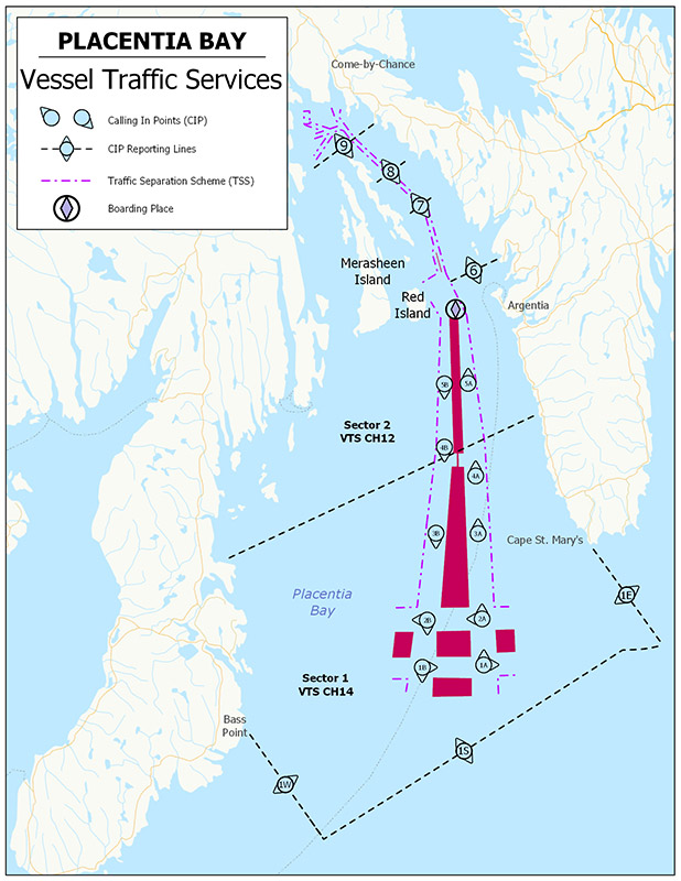
Text description of Figure 3-8 - Placentia Bay VTS Zone
This map illustrates the Placentia Bay Vessel Traffic Services zone as described in detail in Table 3-10, Table 3-11 and Table 3-12.
Note: Latitude and longitude positions given for the Placentia Bay VTS Zone are in NAD83.
Placentia Bay VTS Zone comprises all Canadian waters between a line bearing 180° True from Bass Point, 46°55’05”N 055°15’55”W; and a line bearing 180° True from Cape St. Mary's light, 46°49’22”N 054°11’49”W.
| Sector | Boundaries |
|---|---|
| 1 | The seaward limit of the zone and a line drawn in a 101°-281° True direction through position 47°08’05”N 054°30’00”W, and extended to the shore. |
| 2 | The inner limit of sector 1, and the shoreline north of the zone. |
| Sector | Identifier | Channel | Frequency (MHz) |
|---|---|---|---|
| 1 | "Placentia Traffic" | 14 | 156.7 |
| 2 | "Placentia Traffic" | 12 | 156.6 |
Note: Placentia Traffic monitors navigation in the VTS zone using RADAR and AIS.
| Number | Sector | Name | General Description and Conditions | Geographic Description |
|---|---|---|---|---|
| 1W | 1 | - | - | A line bearing 180° True from Bass Point, 46°55’05”N 055°15’55”W, to the limit of Canadian waters. |
| 1S | 1 | - | - | A line following the Canadian Territorial Sea boundary from position 46°39’55”N 055°15’55”W, to position 46°31’02”N 054°11’49”W. |
| 1E | 1 | - | - | A line bearing 180° True from Cape St. Mary's light, 46°49’22”N 054°11’49”W, to the limit of Canadian waters. |
| 1A | 1 | - | Inbound | A point at 46°45’25”N 054°37’44”W. |
| 2A | 1 | - | Inbound | A point at 46°49’46”N 054°33’30”W. |
| 3A | 1 | - | Inbound | A point at 46°57’52”N 054°25’41”W. |
| 4A | 2 | - | Inbound | A point at 47°03’21.1”N 054°20’17.9”W. |
| 5A | 2 | - | Inbound | A point at 47°12’22”N 054°12’08”W. |
| 1B | 1 | - | Outbound | A point at 46°49’18”N 054°46’15”W. |
| 2B | 1 | -- | Outbound | A point at 46°53’20”N 054°40’56”W. |
| 3B | 1 | - | Outbound | A point at 47°00’44”N 054°31’18”W. |
| 4B | 1 | - | Outbound | A point at 47°08’07”N 054°21’38”W. |
| 5B | 2 | - | Outbound | A point at 47°13’54”N 054°15’24”W. |
| 6 | 2 | - | - | A line 101°-281° True through 47°23’01”N 054°05’13”W and extended to the shore. |
| 7 | 2 | - | - | A line 090°-270° True through 47°31’55”N 054°00’32”W and extended to the shore. |
| 8 | 2 | - | - | A line 090°-270° True through 47°37’01”N 054°01’53”W and extended to the shore. |
| 9 | 2 | - | - | A line 090°-270° True through 47°42’35”N 054°03’22”W and extended to the shore |
All times shall be given in UTC, unless transiting only in one Time Zone. Placentia Bay VTS Zone operates in Newfoundland Standard Time (NST) or Newfoundland Daylight Saving Time (NDT).
3.7.3.2 St. John’s VTS Zone
Figure 3-9 - St. John's VTS Zone
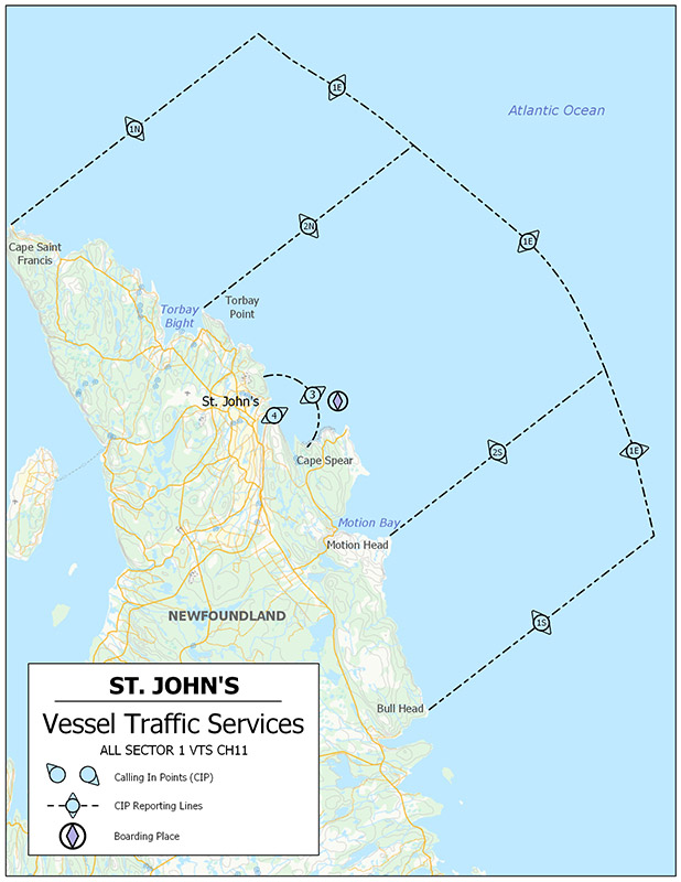
Text description of Figure 3-9 - St. John's VTS Zone
This map illustrates the St. John’s Vessel Traffic Services zone as described in detail in Table 3-13, Table 3-14 and Table 3-15.
Note: Latitude and longitude positions given for the St. John’s VTS Zone are in NAD83.
St. John’s VTS Zone comprises all Canadian waters between a line bearing 090° True from Cape St. Francis Light, 47°48’32”N 052°47’09.6”W, and a line bearing 090° True from Bull Head Light 47°18’39”N 052°44’52”W, including the Port of St. John’s.
| Sector | Boundaries |
|---|---|
| 1 | A line from Cape St. Francis, 47°48’31.5”N 052°47’09.6”W easterly to the Territorial Sea boundary at position 47°48’29.5”N 052°25’30.1”W; thence along the Territorial Sea boundary to position 47°18’36.3”N 052°25’14.8”W, thence, westerly to North Head, 47°18’38”N 052°44’46”W. |
| Sector | Identifier | Channel | Frequency (MHz) |
|---|---|---|---|
| 1 | “St. John’s Traffic” | 11 | 156.55 |
Note: St. John's Traffic monitors navigation in the VTS zone using AIS.
| Number | Sector | Name | Geographic Description |
|---|---|---|---|
| 1N | 1 | Cape St-Francis | A line from 47°48’31.5”N 052°47’09.6”W, to the limit of Canadian territorial waters at 47°48’29.5”N 052°25’30.1”W. |
| 1E | 1 | Eastern Zone Limit | A line following the Canadian Territorial Sea Boundary from 47°48’29.5”N 052°25’30.1”W, to 47°18’36.3”N 052°25’14.8”W. |
| 1S | 1 | North Head | A line from 47°18’38”N 052°44’46”W, to the limit of Canadian territorial waters at 47°18’36.3”N 052°25’14.8”W. |
| 2N | 1 | Torbay Point | A line from 47°39’56.2”N 052°40’05”W, to the limit of Canadian territorial waters at 47°39’54.8”N 052°21’46.3”W. |
| 2S | 1 | Motion Head | A line from 47°26’11”N 052°39’33.2”W, to the limit of Canadian territorial waters at 47°26’09.5”N 052°20’50.9”W. |
| 3 | 1 | 2 NM off St. John’s | An arc centred on Fort Amherst light, 47°33’47.9”N 052°40’49.6”W, and connecting points at 47°35’39.8”N 052°39’45.2”W; 47°33’35.4”N 052°37’53.2”W; and 47°31’49.5”N 052°40’20.3”W. |
| 4 | 1 | Fort Amherst | A point on the range line at 47°33’56.2”N 052°40’48.2”W, abeam Fort Amherst light at 47°33’47.9”N 052°40’49.6”W. |
All times shall be given in UTC, unless transiting only in one Time Zone. St. John’s VTS Zone operates in Newfoundland Standard Time (NST) or Newfoundland Daylight Saving Time (NDT).
3.7.3.3 Port aux Basques VTS Zone
Figure 3-10 - Port aux Basques VTS Zone
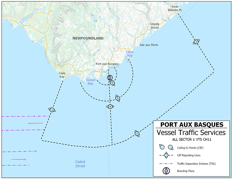
Text description of Figure 3-10 - Port aux Basques VTS Zone
This map illustrates the Port aux Basques Vessel Traffic Services zone as described in detail in Table 3-16, Table 3-17 and Table 3-18.
Note: Latitude and longitude positions given for the Port aux Basques VTS Zone are in NAD83.
Port aux Basques VTS Zone comprises all Canadian waters adjacent to the west and southwest coasts of Newfoundland between a line bearing 232° True from Cape Ray Light, 47°37’17.1”N 059°18’16.8”W and a line bearing 180° True from Rose Blanche Pt. Light, 47°35’57”N 058°41’30”W.
| Sector | Boundaries |
|---|---|
| 1 | From Cape Ray, at 47°37’04”N 059°18’05”W, along the boundary between Fishing zones 1 and 4, to position 47°29’56”N 059°32’20.4”W; thence along an arc centered on position 47°43’07”N 059°05’59.7”W, and connecting the following points: 47°28’18.1”N 059°30’21.7”W, 47°26’48.2”N 059°28’10”W, 47°25’27.1”N 059°25’46.3”W, 47°24’15.6”N 059°23’12.1”W, 47°23’14.4”N 059°20’28.6”W, 47°22’24”N 059°17’37.4”W, thence, along the Canadian Territorial Sea boundary to position 47°23’37.3”N 058°42’01.9”W; thence 000° True to Rose Blanche Point Light, at 47°36’06.5”N 058°41’40.4”W. |
| Sector | Identifier | Channel | Frequency (MHz) |
|---|---|---|---|
| 1 | “Port aux Basques Traffic” | 11 | 156.55 |
Note: Port aux Basques Traffic monitors navigation in the VTS zone using RADAR and AIS.
| Number | Sector | Name | General Description and Conditions | Geographic Description |
|---|---|---|---|---|
| 1 | 1 | Cape Ray | Off Cape Ray | From Cape Ray, at 47°37’04”N 059°18’05”W, along the boundary between Fishing zones 1 and 4, to position 47°29’56”N 059°32’20.4”W. |
| 2 | 1 | Southern limit | Crossing the southern zone limit |
An arc, centred on position 47°43’07”N 059°05’59.7”W, and connecting the following points: 47°29’56”N 059°32’20.4”W, 47°28’18.1”N 059°30’21.7”W, 47°26’48.2”N 059°28’10”W, 47°25’27.1”N 059°25’46.3”W, 47°24’15.6”N 059°23’12.1”W, 47°23’14.4”N 059°20’28.6”W, 47°22’24”N 059°17’37.4”W; - thence, along the Canadian Territorial Sea boundary to position 47°23’37.3”N 058°42’01.9”W. |
| 3 | 1 | Rose Blanche | Off Rose Blanche Point | A line bearing 180° True from Rose Blanche Point, at position 47°36’06.5”N 058°41’40.4”W, to the limit of Canadian waters at 47°23’37.3”N 058°42’01.9”W. |
| 4 | 1 | Ferry Track | Crossing the Port aux Basques, NL, North Sydney, NS, recommended ferry track |
A line from position 47°33’00”N 059°07’27.4”W, to the southern limit of the zone at position 47°22’09”N 059°16’26.6”W. |
| 5 | 1 | 5 NM off Channel Head | 5 NM off Channel Head | An arc centered on 47°33’57”N 059°07’24.5”W, Radius 5 NM, and extending from shore to shore, connecting the following points: 47°35’09.7”N 059°00’14.4”W and 47°28’57”N 059°07’24.5”W and 47°36’02.8”N 059°14’07”W. |
| 6 | 1 | 2 NM off Channel Head | 2 NM off Channel Head | An arc centered on 47°33’57”N 059°07’24.5”W, Radius 2 NM, and extending from shore to shore, connecting the following points: 47°34’27”N 059°04’32.8”W, 47°31’57”N 059°07’24.5”W and 47°34’12.2”N 059°10’20.4”W. |
All times shall be given in UTC, unless transiting only in one Time Zone. Port aux Basques VTS Zone operates in Newfoundland Standard Time (NST) or Newfoundland Daylight Saving Time (NDT).
3.7.3.4 Halifax Harbour and Approaches VTS Zone
Figure 3-11 - Halifax Harbour and Approaches VTS Zone
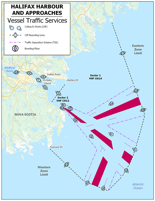
Text description of Figure 3-11 - Halifax Harbour and Approaches VTS Zone
This map illustrates the Halifax Harbour and Approaches Vessel Traffic Services zone as described in detail in Table 3-19, Table 3-20 and Table 3-21.
Note: Latitude and longitude positions given for Halifax Harbour and Approaches VTS Zone are in NAD83.
The Halifax Harbour and Approaches VTS Zone comprises all Canadian waters contained within an area bounded by a line connecting points from Point Pennant, 44°25’53.8”N 063°38’56.5”W; to position 44°17’41.3”N 063°35’09.6”W; to the Canadian territorial boundary at 44°14’02”N 063°30’50.3”W; thence, along Canada‘s territorial boundary to a point at 44°22’43.5”N 063°13’48.5”W, and thence, along a line to Petpeswick (Collies) Head, 44°40’43.3”N 063°09’44.2”W.
| Sector | Boundaries |
|---|---|
| 1 | The seaward boundary of the zone, and a line connecting points from Hartlen Point, 44°35’20.5”N 063°27’05.8”W; to position 44°30’13.8”N 063°28’46.7”W; thence, to Duncan Reef light buoy, H1, 44°29’36”N 063°30’34”W, and thence, to the shore west of Duncan Reef, 44°29’36”N 063°31’28.1”W. |
| 2 | The inner boundary of sector 1 and the shoreline northward and westward of the inner boundary of sector 1. |
| Sector | Identifier | Channel | Frequency (MHz) |
|---|---|---|---|
| 1 | “Halifax Traffic” | 14 | 156.7 |
| 2 | “Halifax Traffic” | 12 | 156.6 |
Note: Halifax Traffic monitors navigation in the VTS zone using RADAR and AIS.
| Number | Sector | Name | General Description and Conditions | Geographic Description |
|---|---|---|---|---|
| 1A | 1 | - | Boundary limit. Entrance to traffic lane. | A point at 44°27’35.6”N 063°12’42.6”W. |
| 2A | 1 | - | Inward traffic only. | A point at 44°27’39.3”N 063°19’37.6”W. |
| 1B | 1 | - | Boundary limit. Traffic lane exit. | A point at 44°23’42.7”N 063°13’35.2”W. |
| 1C | 1 | - | Boundary limit. Entrance to traffic lane. | A point at 44°18’13.2”N 063°19’57.3”W. |
| 2C | 1 | - | Inward traffic only. | A point at 44°22’44.6”N 063°23’21”W. |
| 1D | 1 | - | Boundary limit. Traffic lane exit. | A point at 44°15’46.2”N 063°24’26.4”W. |
| 2D | 1 | - | Outward traffic only. | A point at 44°24’14”N 063°28’09.1”W. |
| 1E | 1 | - | Boundary limit. Entrance to traffic lane. | A point at 44°14’47.8”N 063°31’44.4”W. |
| 1F | 1 | - | Boundary limit. Traffic lane exit. | A point at 44°17’07”N 063°34’29”W. |
| 1S | 1 | - | Western limit zone. | A line joining: 44°25'53.8"N 063°38'56.5"W and 44°17'41.3"N 063°35'09.6"W. |
| 1Y | 1 | - | Eastern limit of zone. | A line joining: 44°40’43.3”N 063°09’44.2”W and 44°28’42.3”N 063°12’27.6”W. |
| 3D | 1 | - | Outward traffic only. | A point at 44°28’12.6”N 063°29’45.9”W. |
| 4C | 2 | Inner Automatic Inward | Vessels inward shall state whether passing east or west of Neverfail Shoal buoy. |
A point at 44°31’31.9”N 063°30’31.6”W. |
| 4D | 2 | Inner Automatic Outward | Vessels shall state course and ETA to 3D. |
A point at 44°31’15.2”N 063°31’16.1”W. |
| 5 | 2 | Neverfail Shoal | - | A line joining points at: 44°34’47.8”N 063°27’34”W; 44°33’23.2”N 063°31’51.9”W and 44°32’59.3”N 063°33’04.6”W. |
| 6 | 2 | Maugher Beach light | Vessels outward shall state if passing east or west of Neverfail Shoal buoy. | A line joining: 44°36’07.7”N 063°32’02.5”W and 44°35’50.2”N 063°33’04.7”W. |
| 7 | 2 | Ives Knoll | Vessels inward shall state whether passing east or west of Georges Island. | A line joining light buoy “HT2”, 44°37’50.2”N 063°32’44.7”W; 44°37’33.9”N 063°33’34.7”W. |
| 8 | 2 | Indian Point | - | A line joining: 44°37’37.9”N 063°31’48.8”W and 44°37’59.1”N 063°31’31.8”W. |
| 9 | 2 | Ferry Track | Vessels outward shall state whether passing east or west of Georges Island. | A line joining: 44°39’47.3”N 063°34’09.9”W and 44°39’23.7”N 063°34’38.4”W. |
| 10 | 2 | Bedford Basin | - | A line joining: 44°40’18.9”N 063°37’25.6”W and 44°41’22.6”N 063°36’58.3”W. |
All times shall be given in UTC, unless transiting only in one Time Zone. Halifax Harbour and Approaches VTS Zone operates in Atlantic Standard Time (AST) or Atlantic Daylight Saving Time (ADT).
3.7.3.5 Strait of Canso and Eastern Approaches VTS Zone
Figure 3-12 - Strait of Canso and Eastern Approaches VTS Zone
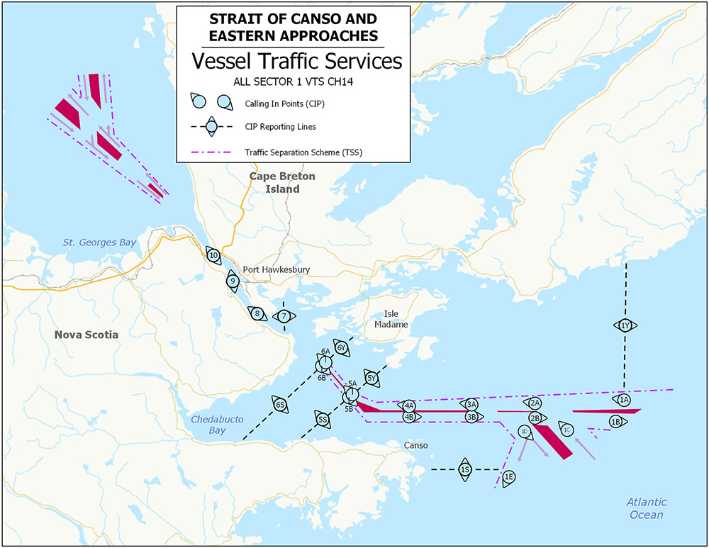
Text description of Figure 3-12 - Strait of Canso and Eastern Approaches VTS Zone
This map illustrates the Strait of Canso and Eastern Approaches Vessel Traffic Services zone as described in detail in Table 3-22, Table 3-23 and Table 3-24.
Note: Latitude and longitude positions given for the Strait of Canso and Eastern Approaches VTS Zone are in NAD83.
| Sector | Boundaries |
|---|---|
| 1 | All Canadian waters south of the Canso canal north lock gate, 45°38’58.2”N 061°24’57.3”W, contained within the area bounded by a line connecting points 45°38’23.3”N 060°29’15.3”W, 45°25’48.8”N 060°29’34”W, and the Canadian territorial boundary at 45°24’09.3”N 060°29’34.3”W; thence, along Canada’s territorial boundary to a point at 45°18’19.8”N 060°35’03.7”W; and thence, along a line to Cape Canso at 45°18’21.8”N 060°56’16.3”W. |
| Sector | Identifier | Channel | Frequency (MHz) |
|---|---|---|---|
| 1 | ”Canso Traffic” | 14 | 156.7 |
Note: Canso Traffic monitors navigation in the VTS zone using RADAR and AIS.
| Number | Sector | Name | General Description and Conditions | Geographic Description |
|---|---|---|---|---|
| 1Y | 1 | - | - | A line from 45°38’23.3”N 060°29’15.3”W, to 45°25’48.8”N 060°29’34”W. |
| 1A | 1 | - | Entrance to inbound traffic lane | A line from 45°25’48.8”N 060°29’34”W, to the Canadian territorial limit at 45°24’9.3”N 060°29’34.3”W. |
| 1B | 1 | - | Exit from outbound traffic lane | A line from 45°23’43.9”N 060°29’58.3”W, along Canada’s territorial boundary, to 45°22’09”N 060°31’27.8”W. |
| 1C | 1 | - | Entrance to inbound traffic lane | A line from 45°20’53”N 060°32’39.5”W, along Canada’s territorial boundary, to 45°18’36.8”N 060°34’47.7”W. |
| 1D | 1 | - | Exit from outbound traffic lane | A line from 45°18’20.1”N 060°36’30.3”W, to 45°18’20.8”N 060°41’06.3”W. |
| 1E | 1 | - | Exit from outbound traffic lane | A line from 45°18’20.8”N 060°41’06.3”W, to 45°18’21.3”N 060°46’04.2”W. |
| 1S | 1 | - | - | A line from 45°18’21.3”N 060°46’04.2”W, to 45°18’21.8”N 060°56’16.3”W. |
| 2A | 1 | - | Inbound traffic lane | A point at 45°24’40.3”N 060°41’39.3”W. |
| 2B | 1 | - | Outbound traffic lane | A point at 45°23’17”N 060°41’39.3”W. |
| 3A | 1 | - | Inbound traffic lane | A point at 45°24’32.5”N 060°50’16.3”W. |
| 3B | 1 | - | Outbound traffic lane | A point at 45°23’24.5”N 060°50’16.3”W. |
| 4A | 1 | - | Inbound traffic lane | A point at 45°24’24.3”N 060°58’45.3”W. |
| 4B | 1 | - | Outbound traffic lane | A point at 45°23’24.3”N 060°58’45.3”W. |
| 5S | 1 | - | - | A line from 45º21’08.3”N 061º13’49.3”W to 45º25’05.8”N 061º07’10.9”W. |
| 5B | 1 | - | Outbound traffic lane | A point at 45º25’14.2”N 061º06’57.0”W. |
| 5A | 1 | - | Inbound traffic lane | A point at 45º25’31.3”N 061º06’28.1”W. |
| 5Y | 1 | - | - | A line from 45º28’31.3”N 061º01’25.3”W to 45º25’37.8”N 061º06’17.4”W. |
| 6S | 1 | - | - | A line from 45º20’58.3”N 061º21’43.4”W to 45º28’07.2”N 061º10’49.8”W. |
| 6B | 1 | - | Outbound traffic lane | A point at 45º28’15.2”N 061º10’26.0”W. |
| 6A | 1 | - | Inbound traffic lane | A point at 45º28’37.8”N 061º10’03.4”W. |
| 6Y | 1 | - | - | A line from 45º31’15.3”N 061º05’59.5”W to 45º28’42.0”N 061º09’56.4”W. |
| 7 | 1 | C14 buoy | - | A line from 45°34’42.3”N 061°15’52.6”W to 45°31’13.8”N 061°15’40.4”W. |
| 8 | 1 | Critchett Point | - | A line from 45°33’34.3”N 061°19’03.4”W to 45°32’52.3”N 061°19’44.4”W. |
| 9 | 1 | C26 buoy | - | A line from 45°36’23.2”N 061°22’14.3”W to 45°36’15.2”N 061°23’13.2”W. |
| 10 | 1 | Canal North Lock Gate | - | Canso Canal North Lock Gate, 45°38’58.2”N 061°24’57.3”W. |
All times shall be given in UTC, unless transiting only in one Time Zone. Strait of Canso and Eastern Approaches VTS Zone operates in Atlantic Standard Time (AST) or Atlantic Daylight Saving Time (ADT).
3.7.3.6 Northumberland Strait VTS Zone
Figure 3-13 - Northumberland Strait VTS Zone
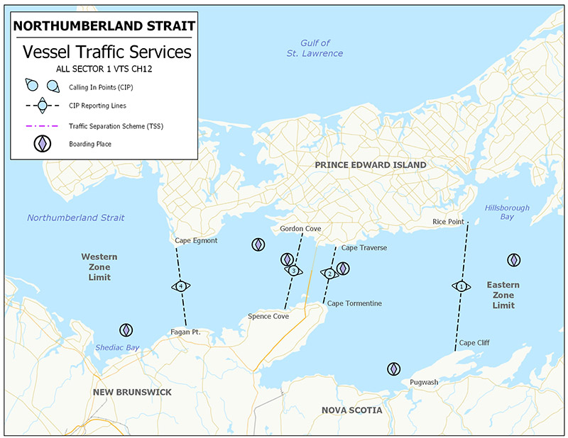
Text description of Figure 3-13 - Northumberland Strait VTS Zone
This map illustrates the Northumberland Strait Vessel Traffic Services zone as described in detail in Table 3-25, Table 3-26 and Table 3-27.
Note: Latitude and longitude positions given for the Northumberland Strait VTS Zone are in NAD83.
| Sector | Boundaries |
|---|---|
| 1 | All waters of Northumberland Strait extending west from a line drawn between Cape Cliff, N.S., 45°52’42.3”N 063°27’59.3”W, to Rice Point, P.E.I., 46°07’47.9”N 063°13’18.3”W, to a line drawn between Fagan Point, N.B., 46°13’41.8”N 064°13’42”W, to Cape Egmont, P.E.I., 46°24’04.8”N 064°08’05.3”W. |
| Sector | Identifier | Channel | Frequency (MHz) |
|---|---|---|---|
| 1 | “Northumberland Traffic” | 12 | 156.6 |
Note: Northumberland Traffic monitors navigation in the VTS zone using AIS.
| Number | Sector | Name | General Description and Conditions | Geographic Description |
|---|---|---|---|---|
| 1 | 1 | Eastern Zone Boundary | A line joining: Cape Cliff, N.S. and Rice Point, P.E.I. |
A line joining: 45°52’42.3”N 063°27’59.3”W and 46°07’47.9”N 063°13’18.3”W. |
| 2 | 1 | Eastern Approach Security Zone | A line joining: Cape Tormentine, N.B. and Cape Traverse, P.E.I. |
A line joining: 46°07’24.6”N 063°46’56.5”W and 46°13’51.2”N 063°38’58”W. |
| 3 | 1 | Western Approach Security Zone | A line joining: Spence Cove, N.B. and Gordon Cove, P.E.I. |
A line joining: 46°09’15.3”N 063°54’21.6”W and 46°17’34.1”N 063°43’53.1”W. |
| 4 | 1 | Western Zone Boundary | A line joining: Fagan Point, N.B. and Cape Egmont, P.E.I. |
A line joining: 46°13’41.8”N 064°13’42”W and 46°24’04.8”N 064°08’05.3”W. |
All times shall be given in UTC, unless transiting only in one Time Zone. Northumberland Strait VTS Zone operates in Atlantic Standard Time (AST) or Atlantic Daylight Saving Time (ADT).
3.7.3.7 Bay of Fundy VTS Zone
Figure 3-14 - Bay of Fundy VTS Zone
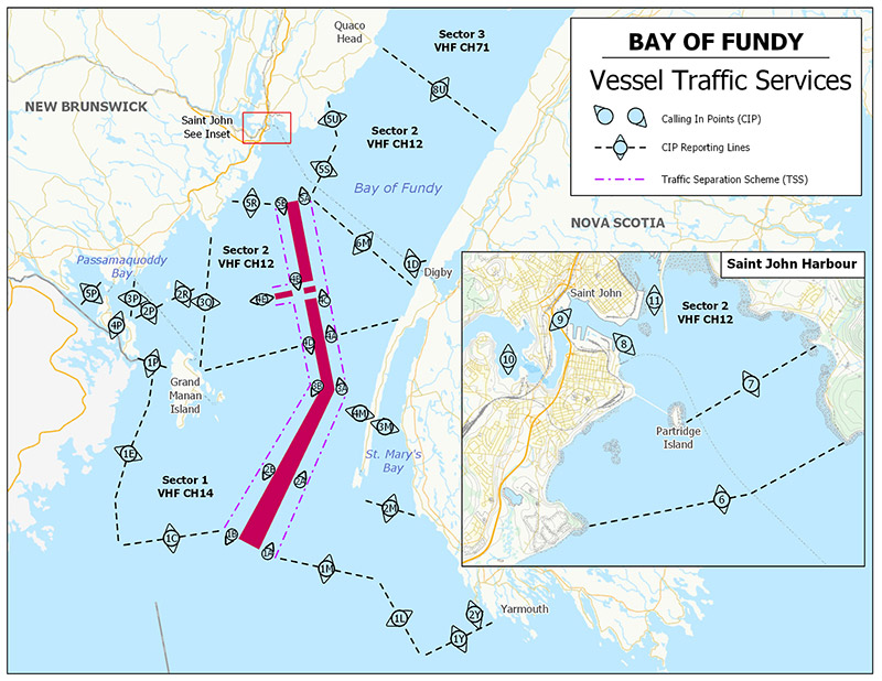
Text description of Figure 3-14 - Bay of Fundy VTS Zone
This map illustrates the Bay of Fundy Vessel Traffic Services zone as described in detail in Table 3-28, Table 3-29 and Table 3-30.
Note: Latitude and longitude positions given for the Bay of Fundy VTS Zone are in NAD83.
The Bay of Fundy VTS Zone comprises all Canadian waters contained within the area bounded by a line drawn in a 270° True direction from Chebogue Point in position 43°43’54.3”N, 066°07’08.0”W; thence through the following positions:
- 43°43’54.3”N 066°26’28”W, 43°58’45.3”N 066°27’43”W, 44°09’30.3”N 066°47’01”W,
- 44°11’50.3”N 066°49’31”W, 44°14’57.3”N 066°52’40”W, 44°17’21.2”N 066°55’08”W,
- 44°22’30.2”N 067°18’58.1”W, 44°29’50.2”N 067°15’08.1”W, 44°35’30.2”N 067°08’13”W,
- 44°42’00.2”N 066°58’22”W, 44°46’35.6”N 066°54’09.2”W
- thence along the Canada/USA boundary line to the shore at 45°11’30.5”N 067°17’00.6”W;
- thence following the Canadian shores of New Brunswick and Nova Scotia back to the beginning at Chebogue Point, including Fishing Zone 2.
| Sector | Boundaries |
|---|---|
| 1 | The outer limit of the zone, and a line joining the following positions: 45°03’29.2”N 066°27’32.8”W, 44°53’14.6”N 066°36’00.1”W, 44°43’08.8”N 066°44’16.6”W, 44°36’38”N 065°56’28.7”W. |
| 2 | From the inner boundary of sector 1 eastward to a line joining 45°19’22.5”N 065°32’05.4”W; and 44°56’54.3”N 065°15’49.4”W, and including the waters of Saint John Harbour northward to a line joining Pleasant Point, 45°16’28.7”N 066°05‘47.1”W; and Pokiok, 45°16’38.3”N 066°05’34.5”W. |
| 3 | All of the waters encompassed by the shores of New Brunswick and Nova Scotia east of a line joining 45°19’22.5”N 065°32’05.4”W; and 44°56’54.3”N 065°15’49.4”W; which is described as the eastern limit of sector 2. |
| Sector | Identifier | Channel | Frequency (MHz) |
|---|---|---|---|
| 1 | “Fundy Traffic” | 14 | 156.7 |
| 2 | “Fundy Traffic” | 12 | 156.6 |
| 3 | “Fundy Traffic” | 71 | 156.575 |
Note: Fundy Traffic monitors navigation in the VTS zone using RADAR and AIS.
| Number | Sector | Name | General Description and Conditions | Geographic Description |
|---|---|---|---|---|
| 1A | 1 | - | Southwest entrance to traffic separation scheme Inward | A point at 44°10’40.3”N 066°48’16”W. |
| 1B | 1 | - | Southwest exit from traffic separation scheme Outward | A point at 44°16’09.3”N 066°53’54”W. |
| 2A | 1 | - | Inward traffic only | A point at 44°19’11.4”N 066°34’12.4”W. |
| 2B | 1 | - | Outward traffic only | A point at 44°23’16.9”N 066°39’28”W. |
| 3A | 1 | - | Inward traffic only | A point at 44°30’09.3”N 066°15’56.5”W. |
| 3B | 1 | - | Outward traffic only | A point at 44°32’25.8”N 066°20’46”W. |
| 4A | 1 and 2 | - | Sector boundary – Inward traffic only |
A point at 44°38’53.3”N 066°12’43.9”W. |
| 4B | 2 | - | Outward traffic only | A point at 44°50’17.8”N 066°14’19.5”W. |
| 4C | 2 | - | Inward traffic only | A point at 44°44’49.1”N 066°10’32.7”W. |
| 4D | 1 and 2 | - | Sector boundary – Outward traffic only |
A point at 44°39’38.1”N 066°18’11.2”W. |
| 4E | 2 | - | Entrance to/exit from traffic separation scheme | A point at 44°49’38.3”N 066°23’40.2”W. |
| 5A | 2 | - | North exit from traffic separation scheme – Inward traffic only |
A point at 45°01’45.3”N 066°04’08.4”W. |
| 5B | 2 | - | North entrance to traffic separation scheme – Outward traffic only |
A point at 45°02’45.3”N 066°09’35.4”W. |
| 6 | 2 | Saint John Harbour light and whistle Buoy J | - | A line joining: 45°13’30.4”N 066°05’45.1”W; 45°12’55.3”N 066°02’36.9”W; 45°12’59.3”N 066°00’28.2”W. |
| 7 | 2 | Partridge Island | - | A line joining: 45°14’10.3”N 066°03’12.1”W and 45°14’20.3”N 066°00’07.9”W. |
| 8 | 2 | - | - | A point at 45°15’30.3”N 066°03’31.3”W. |
| 9 | 2 | - | - | A point at 45°16’10.9”N 066°04’24.9”W. |
| 10 | 2 | - | - | A point at 45°16’00.5”N 066°05’39.1”W. |
| 11 | 2 | - | - | A point at 45°15’51.5”N 066°02’37.6”W. |
| 1C | 1 | - | Outer boundary – Sector 1 | A line joining: 44°17’21.2”N 066°55’08”W and 44°22’30.2”N 067°18’58.1”W. |
| 1E | 1 | - | Outer boundary – Sector 1 Grand Manan Channel | A line joining: 44°22’30.2”N 067°18’58.1”W; 44°29’50.2”N 067°15’08.1”W; 44°35’30.2”N 067°08’13”W; 44°42’00.2”N 066°58’22”W; 44°46’35.6”N 066°54’09.2”W; 44°47’39.1”N 066°53’07.5”W. |
| 1P | 1 | - | Grand Manan Channel | A line joining: 44°45’35.7”N 066°50’01.9”W and 44°45’37”N 066°50’03”W, and thence along the boundary between Fishing zones 2 and 4 to 44°47’39.1”N 066°53’07.5”W; thence, along the Canada/US boundary to 44°49’31.8”N 066°55’57.3”W, and along the extension of this boundary to 44°50’16.8”N 066°57’05.2”W. |
| 2P | 1 | - | Campobello Island to The Wolves |
A line joining: 44°55’57.4”N 066°53’55.3”W and 44°56’09.8”N 066°44’04.3”W. |
| 2R | 1 | - | Southwest Wolf Island to sector boundary | A line joining: 44°56’10.6”N 066°43’57.7”W and 44°53’14.6”N 066°36’00.1”W. |
| 3Q | 1 and 2 | - | Sector Boundary | A line joining: 44°43’08.8”N 066°44’16.6”W, 44°53’14.6”N 066°36’00.1”W, 45°03’29.2”N 066°27’32.8”W. |
| 5R | 2 | - | - | A line joining: 45°03’00.3”N 066°10’58”W; 45°03’36.3”N 066°12’22”W; 45°07’06.7”N 066°20’50.8”W. |
| 3P | 1 | - | - | A line joining: 45°02’19.6”N 066°48’31.1”W; 44°55’57.4”N 066°53’55.3”W. |
| 4P | 1 | - | Head Harbour Passage | A line joining: 44°56’48.5”N 066°58’14”W; 44°55’40.6”N 066°56’37.4”W. |
| 5P | 1 | - | Passamaquoddy Bay | A line joining: 45°04’17”N 066°55’12.6”W and a position on the Canada/US boundary line at 45°01’36.7”N 067°03’56.6”W. |
| 1M | 1 | - | Outer boundary – Sector 1 southwest of Brier Island | A line joining: 43°58’45.3”N 066°27’43”W; 44°09’30.3”N 066°47’01”W. |
| 2M | 1 | - | Entrance to St. Mary’s Bay | A line joining: 44°05’12”N 066°12’42.8”W; 44°12’08.3”N 066°23’09”W. |
| 3M | 1 | - | South end of Petit Passage | An arc centered on 44°22’21”N 066°12’12”W; Radius 1½ NM, and extending from shore to shore in the waters of St. Mary’s Bay, connecting the following points: 44°23’31.3”N 066°10’53.6”W; 44°21’15.2”N 066°10’46.4”W; and 44°21’19.9”N 066°13’44.1”W. |
| 4M | 1 | - | North end of Petit Passage | An arc centered on 44°24’14.5”N 066°12’55”W; Radius 1½ NM, and extending from shore to shore in the waters of the Bay of Fundy, connecting the following points: 44°23’02.8”N 066°14’10.8”W; 44°25’19.6”N 066°14’21.7”W; and 44°25’21.9”N 066°11’31.8”W. |
| 6M | 2 | - | - | A line joining: 44°39’56.6”N 065°49’57.2”W and 45°01’30.3”N 066°02’46”W. |
| 5U | 2 | - | - | A line joining: 45°08’02.3”N 065°50’56.9”W and 45°15’24.3”N 065°48’39.9”W. |
| 1D | 2 | - | Entrance/Exit to Digby Gut | An arc centered on 44°42’38.8”N 065°46’23.9”W; Radius 2 NM and extending from shore to shore in the waters of the Bay of Fundy, connecting the following points: 44°41’03.7”N 065°48’06.6”W; 44°44’00.3”N 065°48’27.5”W and 44°43’09.9”N 065°43’41.4”W. |
| 5S | 2 | - | - | A line joining: 45°01’30.3”N 066°02’46”W and 45°08’02.3”N 065°50’56.9”W. |
| 8U | 2 and 3 | - | Boundary – Sectors 2 / 3 | A line joining: 45°19’22.5”N 065°32’05.4”W and 44°56’54.3”N 065°15’49.4”W. |
| 1L | 1 | - | Outer boundary – Sector 1 west of Yarmouth, NS. | A line joining: 43°43’54.3”N 066°26’28”W and 43°58’45.3”N 066°27’43”W. |
| 1Y | 1 | - | Outer boundary – Bay of Fundy VTS zone near Yarmouth, NS | A line joining: 43°43’54.3”N 066°07’08”W and 43°43’54.3”N 066°26’28”W. |
| 2Y | 1 | - | Yarmouth Sound | An arc centered on 43°46’57.3”N 066°09’29.5”W; Radius 1½ NM, and extending from shore to shore in the waters off Yarmouth Sound, connecting the following points: 43°46’08.4”N 066°07’45.2”W; 43°46’29.7”N 066°11’27.7”W and 43°48’24.5”N 066°10’00.3”W. |
All times shall be given in UTC, unless transiting only in one Time Zone. Bay of Fundy VTS Zone operates in Atlantic Standard Time (AST) or Atlantic Daylight Saving Time (ADT).
3.7.3.8 St. Lawrence River
Figure 3-15a - St. Lawrence River VTS Zone
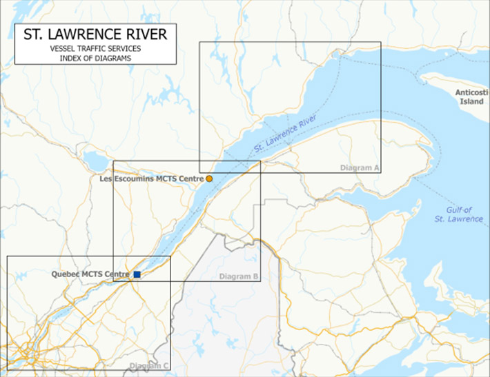
Text description of Figure 3-15a - St. Lawrence River VTS Zone
The St. Lawrence-Waterway Vessel Traffic Services zone that extends from the Gulf of St. Lawrence to the Port of Montréal is illustrated with four nautical charts.
The first is a general nautical chart representing the traffic zone from the Gulf of St. Lawrence to Montréal, including the Saguenay River. The three squares labelled A, B and C cascading in a north-easterly direction indicate the nautical charts covering the various vessel traffic zones located along the St. Lawrence Seaway. The Gulf of St. Lawrence and St. Lawrence River are illustrated in blue and the land in yellow. Anticosti Island, located in the northern Gulf of St. Lawrence, appears in yellow with the name of the island indicated on it.
Figure 3-15b - St. Lawrence River VTS Zone
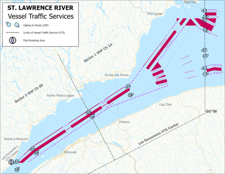
Text description of Figure 3-15b - St. Lawrence River VTS Zone
The second chart illustrates square A from the previous chart, which represents the eastern sector of the Les Escoumins vessel traffic zone. It indicates the zone's limits, which extend west from Longitude 66 degrees West east, to west of Les Escoumins. The zone is also divided into two sectors: sector 1 extends from Longitude 66 degrees West, westward to Pointe Manicouagan, and an eastern portion of sector 2 which extends from Pointe Manicouagan to Les Escoumins. The sectors' limits are shown using magenta dotted lines. A traffic separation scheme indicating the mandatory shipping routes in the sector is represented by a thick magenta line, which separates upbound and downbound vessels. Magenta dotted lines indicate the limits of these corridors. Magenta-coloured arrows indicate the traffic direction in the traffic separation zone corridors. The traffic separation scheme extends from the Les Escoumins pilot station, indicated by a magenta diamond inside a circle, to the Gulf of St. Lawrence. Ships are required to report their position to the Les Escoumins Marine Communications and Traffic Services (MCTS) Centre via VHF radio at those points indicated on the chart with a combined alpha-numeric circle and triangle pointed in the direction of traffic, i.e. depending on whether the ship is upbound or downbound. Sept-Îles and Port-Cartier harbours are indicated on the chart. Some calling-in or reporting points, such as Pointe des Monts, Pointe de Manicouagan and Pointe au Boisvert, are indicated on the chart. Les Escoumins MCTS Centre is also indicated on the chart. The call points are alpha-numeric from east to west: 1A, 1B, 1C, 1D, 1E, 1F, and 1G along Longitude 66 degrees West, 2A and 2B off Pointe des Monts, 3A and 3B off Pointe de Manicouagan, 4A and 4B off Pointe au Boisvert, and 5A and 5B approaching Les Escoumins. East of Pointe Manicouagan on land indicated in yellow, it reads Sector 1 VHF Channel 14, which means that ships in this sector are required to keep their radios tuned to channel VHF 14. West of Pointe Manicouagan, it reads Sector 2 VHF Channel 09, which means that ships in this sector are required to keep their radios tuned to channel VHF 09. A legend in the upper left depicts the signs and symbols used on the chart.
Figure 3-15a - St. Lawrence River VTS Zone
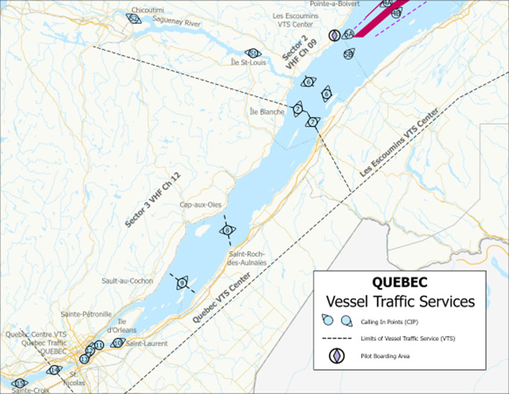
Text description of Figure 3-15c - St. Lawrence River VTS Zone
The third chart illustrates square B from the previous chart, which represents the western part of the Les Escoumins vessel traffic zone and the eastern part of the Québec vessel traffic zone. Chart B represents the portion of the St. Lawrence River that extends from Pointe au Boisvert to Île aux Lièvres and the Saguenay Fjord up to Chicoutimi Harbour. A dotted line passing by Île-Blanche separates the Les Escoumins and Québec vessel traffic zones. The sectors' limits are represented by dotted lines. East of Île-Blanche, vessels are required to report their position to the Les Escoumins MCTS Centre via VHF radio at the points represented on the chart by a combined alpha-numeric circle and triangle pointed in the direction of traffic, i.e. depending on whether the ship is upbound or downbound. West of Île-Blanche, ships are required to report their position to the Québec MCTS Centre via VHF radio at the points represented on the chart with a combined alpha-numeric circle and triangle pointed in the direction of traffic, i.e. depending on whether the ship is upbound or downbound. Chicoutimi harbour in the Saguenay is indicated on the chart. Some calling-in or reporting points, such as, Île-Blanche and Cap-aux-Oies are indicated on the chart. Sector 2 VHF Channel 09 is indicated east of the dotted line that separates the two zones on land represented by the colour yellow; this means that ships in this sector are required to keep their radios tuned to channel VHF 09. West of the line, Sector 3 VHF Channel 12 is indicated, which means that ships in this sector are required to keep their radios tuned to channel VHF 12. A legend in the lower right-hand corner of the chart depicts the signs and symbols used on the chart.
Figure 3-15a - St. Lawrence River VTS Zone
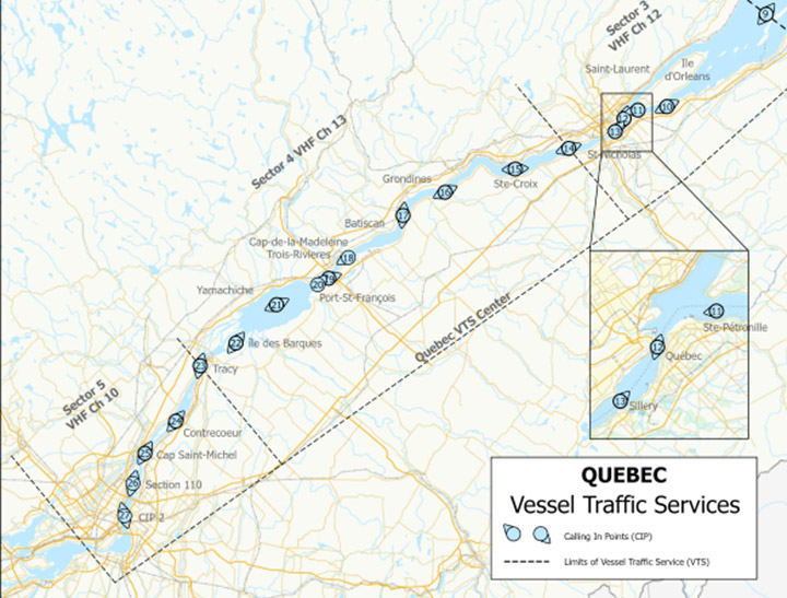
Text description of Figure 3-15d - St. Lawrence River VTS Zone
The following chart is a detailed illustration of Chart C, which represents the western part of the Québec vessel traffic services (VTS) zone and the Montréal VTS zone. In the upper right is the small-scale version of Chart B described above. Chart C shows the portion of the St. Lawrence River that extends from Saint-Charles-de-Grondines to the Port of Montréal. A dotted line passing by Tracy shows the western limit of sector 4 and the Québec VTS zone, and the start of sector 5 of the Québec VTC zone. A dotted line passing by Montréal Harbour shows the western limit of the VTS zone. East of Tracy, vessels are required to report their position to the Québec MCTS Centre via VHF radio at the points represented on the chart by a combined alpha-numeric circle and triangle pointed in the direction of traffic, i.e. depending on whether the ship is upbound or downbound. West of Tracy, ships are required to report their position to the Québec MCTS Centre via VHF radio at the points represented on the chart by a combined alpha-numeric circle and triangle pointed in the direction of traffic, i.e. depending on whether the ship is upbound or downbound. Some calling-in or reporting points, such as Grondines, Batiscan, Cap-de-la-Madeleine, Yamachiche, Contrecœur, Cap-Saint-Michel, Section 110 and CIP2 are indicated on the chart. East of the dotted line separating Sectors 4 and 5 on land represented by the colour yellow, it reads Sector 4 VHF Channel 12; this means that vessels in this sector are required to keep their radios tuned to channel VHF 12. West of the line, it reads Sector 5 VHF Channel 10, which means that ships in this sector are required to keep their radios tuned to channel VHF 10. A legend in the lower right depicts the signs and symbols used on the chart.
The St. Lawrence River VTS Zone comprises the waters of the St. Lawrence River extending upstream from the meridian of longitude 066°00’00 West to the upper limits of the Port of Montréal, including the Saguenay River and other tributary rivers where vessels enter or leave the St. Lawrence River between the above limits, but excluding that portion of the St. Lawrence Seaway from St. Lambert lock to a position 650 metres downstream from the section of Jacques-Cartier bridge spanning the Seaway.
| Sector | Boundaries |
|---|---|
| 1 | The longitudinal meridian crossing the St. Lawrence River at 066°00’00”W, and a line at Pointe de Manicouagan joining positions 49°06’04.3”N 068°11’39.7”W; 48°42’00”N 067°52’00”W (NAD83). |
| 2 | The inner boundary of sector 1 and a line at Cap du Basque joining positions 48°00’06”N 069°45’48”W, 47°58’25”N 069°37’51”W, and 47°52’35”N 069°33’02”W; including the Saguenay River (NAD83). |
| 3 | The inner boundary of sector 2 and a line at Pointe St-Nicholas joining positions 46°42’07”N 071°26’47”W; and 46°43’38”N 071°27’33”W. |
| 4 | The inner boundary of sector 3 and a line at Tracy joining positions 46°00’48”N 073°09’49”W and 46°01’00”N 073°11’00”W. |
| 5 | The inner boundary of sector 4 the upstream limit of the zone. |
| Sector | Identifier | Channel | Frequency (MHz) |
|---|---|---|---|
| 1 | “Escoumins Traffic” | 14 | 156.7 |
| 2 | “Escoumins Traffic” | 9 | 156.45 |
| 3 | “Québec Traffic” | 12 | 156.6 |
| 4 | “Québec Traffic” | 13 | 156.65 |
| 5 | “Québec Traffic” | 10 | 156.5 |
Note: Les Escoumins and Québec Traffic monitor navigation in the VTS zone using RADAR and AIS.
| Number | Sector | Name | General Description and Conditions | Geographic Description |
|---|---|---|---|---|
| 1 | 1 | 66W | Zone limit | Meridian longitude 066°00’00”W. |
| 1A | 1 | 66W | Eastern zone limit inbound | A point at 50°05’30”N 066°00’00”W. |
| 1B | 1 | 66W | Eastern zone limit outbound | A point at 50°01’25”N 066°00’00”W. |
| 1C | 1 | 66W | Eastern zone limit inbound | A point at 49°59’20”N 066°00’00”W. |
| 1D | 1 | 66W | Eastern zone limit outbound | A point at 49°52’30”N 066°00’00”W. |
| 1E | 1 | 66W | Eastern zone limit inbound | A point at 49°38’40”N 066°00’00”W. |
| 1F | 1 | 66W | Eastern zone limit outbound | A point at 49°34’25”N 066°00’00”W. |
| 1G | 1 | 66W | Eastern zone limit inbound | A point at 49°26’15”N 066°00’00”W. |
| 1H | 1 | 66W | Eastern zone limit outbound | A point at 49°22’00”N 066°00’00”W. |
| 2 | 1 | Pointe des Monts | - | A line joining: 49°19’00”N 067°22’30”W and 48°55’18”N 067°16’18”W. |
| 2A | 1 | Pointe des Monts | Upbound | A point at 49°13’40”N 067°21’20”W. |
| 2B | 1 | Pointe des Monts | Downbound | A point at 49°07’30”N 067°19’30”W. |
| 3 | 1/2 | Pointe Manicouagan | - | A line joining: 49°06’04.3”N 068°11’39.7”W and 48°42’00”N 067°52’00”W. |
| 3A | 1/2 | Pointe Manicouagan | Sector boundary Upbound | A point at 48°55’45”N 068°03’20”W. |
| 3B | 1/2 | Pointe Manicouagan | Sector boundary Downbound | A point at 48°52’20”N 068°00’00”W. |
| 4 | 2 | Pointe au Boisvert | - | A line joining: 48°33’55”N 069°08’32”W and 48°19’42”N 068°50’18”W. |
| 4A | 2 | Pointe au Boisvert | Upbound | A point at 48°30’00”N 069°03’00”W. |
| 4B | 2 | Pointe au Boisvert | Downbound | A point at 48°26’48”N 068°59’20”W. |
| 5A | 2 | - | Upbound | A point at 48°20’54”N 069°19’36”W. |
| 5 | 2 | Les Escoumins | - | A line joining: 48°19’05”N 069°24’53”W and 48°08’05”N 069°11’14”W. |
| 5B | 2 | Les Escoumins | Downbound only | A point at 48°15’00”N 069°20’00”W. |
| 6 | 2 | Prince Shoal Light | - | A line joining: 48°09’36”N 069°39’00”W; 48°06’30”N 069°36’53”W; and 48°05’38”N 069°34’01”W and a line joining 48°04’10”N 069°33’19”W; and 48°03’04”N 069°25’29”W. |
| S1 | 2 | Île St-Louis (Saguenay River) | - | A line joining: 48°15’03”N 070°01’09”W and 48°15’45”N 070°01’00”W. |
| S2 | 2 | Chicoutimi | - | A point at 48°25’20”N 070°52’50”W. |
| 7 | 2/3 | Île Blanche | Sector boundary | A line joining: 48°00’06”N 069°45’48”W; 47°58’25”N 069°37’51”W; 47°52’35”N 069°33’02”W. |
| 8 | 3 | Cap-aux-Oies St-Roch | - | A line joining: 47°29’18“N 070°13’55”W and 47°18’42”N 070°10’42”W. |
| 9 | 3 | Sault au Cochon / Beaujeu | - | A line joining: 47°11’49”N 070°38’16”W and 47°05’12”N 070°25’30”W. |
| 10 | 3 | Saint-Laurent | - | A line joining: 46°51’33”N 071°00’16”W and 46°50’09”N 070°59’15”W. |
| 11 | 3 | Ste Pétronille (Île d’Orléans) |
Upbound only | A line joining: 46°50’41.5”N 071°07’57”W and 46°49’42”N 071°07’42”W. |
| 12 | 3 | Québec | - | A line joining: 46°48’38”N 071°12’12”W and 46°48’27”N 071°11’18”W. |
| 13 | 3 | Sillery | Downbound only | A line joining: 46°46’19”N 071°14’37”W; and 46°45’50”N 071°13’50”W. |
| 14 | 3/4 | St-Nicolas | Sector boundary | A line joining: 46°42’07”N 071°26’47”W and 46°43’38”N 071°27’33”W. |
| 15 | 4 | Ste-Croix | - | A line joining: 46°37’40”N 071°42’00”W and 46°40’09”N 071°42’16”W. |
| 16 | 4 | Grondines | - | A line joining: 46°35’14”N 072°02’26”W and 46°33’39”N 072°01’18”W. |
| 17 | 4 | Batiscan | - | A line joining: 46°30’02”N 072°14’47”W and 46°29’51”N 072°12’27”W. |
| 18 | 4 | Cap-de-la-Madeleine | Upbound only | A line joining: 46°21’58.1”N 072°29’47.4”W and 46°21’47”N 072°28’04”W. |
| 19 | 4 | Pointe des Ormes | - | A line joining: 46°18’14”N 072°34’39”W and 46°17’24”N 072°34’15”W. |
| 20 | 4 | Port Saint-François | Downbound only | A line joining: 46°16’21.5”N 072°37’10”W and 46°16’50”N 072°37’48.5”W. |
| 21 | 4 | Yamachiche | - | A line joining: 46°12’53”N 072°49’11.5”W and 46°12’28.9”N 072°48’55”W. |
| 22 | 4 | Île des Barques | - | A line joining: 46°05’24”N 073°00’43”W and 46°05’08”N 073°00’13”W. |
| 23 | 4/5 | Tracy | Sector boundary | A line joining: 46°00’48”N 073°09’49“W and 46°01’00”N 073°11’00”W. |
| 24 | 5 | Contrecœur | - | A line joining: 45°49’55.3”N 073°16’55.7”W and 45°50’15”N 073°17’31”W. |
| 25 | 5 | Cap St-Michel | - | A line joining: 45°44’05”N 073°26’40”W and 45°43’30”N 073°25’15”W. |
| 26 | 5 | Section 110 | - | A point at 45°37’54”N 073°29’18”W. |
| 27 | 5 | Calling in Point 2 | - | A point at 45°31’36”N 073°31’39”W. |
All times shall be given in UTC, unless transiting only in one Time Zone. St. Lawrence River VTS Zone operates in Eastern Standard Time (EST) or Eastern Daylight Saving Time (EDT).
3.7.3.9 Strait of Belle Isle – Voluntary VTS Area
Figure 3-16 - Strait of Belle Isle Voluntary VTS Area
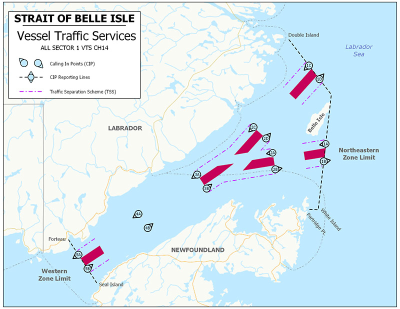
Text description of Figure 3-16 - Strait of Belle Isle Voluntary VTS Area
This map illustrates the Strait of Belle Isle Voluntary Vessel Traffic Services Area as described in detail in Table 3-34, Table 3-35 and Table 3-36.
Note: Latitude and longitude positions given for the Strait of Belle Isle Voluntary VTS Area are in NAD83.
The Canadian Coast Guard has established a voluntary VTS Area in the Strait of Belle Isle, Newfoundland.
The Strait of Belle Isle Voluntary VTS Area includes all waters within the Strait of Belle Isle bounded by a line extending from Double Island, Labrador, 52º15’30”N 055º32’55”W, to Northeast Ledge, Belle Isle, 52º02’11.8”N 055º16’05.6”W, to White Islands, Newfoundland, 51º34’51”N 055º21’05”W; thence, westerly to Partridge Point Light, Newfoundland, 51º34’52.7”N 055º25’16.1”W; thence, westerly along the south shore of the Strait of Belle Isle to Seal Islands, Newfoundland, 51º17’16.2”N 056º45’51.8”W; thence, along a line to Forteau Light, Labrador, 51º28’10.2”N 056º57’12.1”W; and thence, easterly along the north shore of the Strait of Belle Isle to Double Island, Labrador, 52º15’30”N 055º32’55”W.
Vessels required to comply with the VTS Zone Regulations (SOR 2025-275) are requested to participate in the system. Fishing vessels are encouraged to maintain a listening watch or contact “Belle Isle Traffic” on Channel 14 VHF to obtain up-to-date information on vessels reported transiting the Strait of Belle Isle Voluntary VTS Area.
| Sector | Boundaries |
|---|---|
| 1 | Eastern Boundary: A line extending from Double Island, Labrador, 52°15’30”N 055°32’55”W, to Northeast Ledge, Belle Isle, 52°02’11.8”N 055°16’05.6”W, to White Islands, Newfoundland, 51°34’51”N 055°21’05”W; thence, westerly to Partridge Point Light, Newfoundland, 51°34’52.7”N 055°25’16.1”W. Western Boundary: A line joining Seal Island, Newfoundland, 51°17’16.2”N 056°45’51.8”W, to Forteau Light, Labrador, 51°28’10.2”N 056°57’12.1”W. |
| Sector | Identifier | Channel | Frequency (MHz) |
|---|---|---|---|
| 1 | “Belle Isle Traffic” | 14 | 156.7 |
Note: Belle Isle Traffic monitors navigation in the VTS area using AIS.
| Number | Sector | General Description and Conditions | Geographic Description |
|---|---|---|---|
| 1A | 1 | Inbound (Belle Isle South Route) | A point at 51°50’29.2”N 055°18’14.6”W. |
| 2A | 1 | Inbound (Belle Isle South Route) | A point at 51°48’23.8”N 055°38’36.3”W. |
| 3A | 1 | Inbound | A point at 51°43’13.8”N 056°07’28.2”W. |
| 4A | 1 | Inbound | A point at 51°33’50.9”N 056°29’59.4”W. |
| 5A | 1 | Inbound | A point at 51°24’07.6”N 056°52’59”W. |
| 1B | 1 | Outbound (Belle Isle South Route) | A point at 51°46’21.4”N 055°18’59.8”W. |
| 2B | 1 | Outbound (Belle Isle South Route) | A point at 51°44’27.1”N 055°37’32.3”W. |
| 3B | 1 | Outbound | A point at 51°39’53.9”N 056°03’54.3”W. |
| 4B | 1 | Outbound | A point at 51°30’30.7”N 056°26’27.1”W. |
| 5B | 1 | Outbound | A point at 51°20’46.4”N 056°49’29.8”W. |
| 1C | 1 | Inbound (Belle Isle North Route) | A point at 52°09’00.4”N 055°24’40.7”W. |
| 2C | 1 | Inbound (Belle Isle North Route) | A point at 51°54’27.4”N 055°45’53.0”W. |
| 1D | 1 | Outbound (Belle Isle North Route) | A point at 52°05’48.0”N 055°20’37.7”W. |
| 2D | 1 | Outbound (Belle Isle North Route) | A point at 51°51’47.3”N 055°41’04.1”W. |
3.8 Northern VTS Zone and Reporting Requirements
Figure 3-17 - Vessel Traffic Services – the Northern VTS Zone
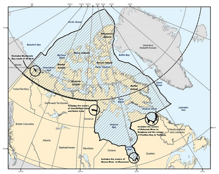
Text description of Figure 3-17 - Vessel Traffic Services – the Northern VTS Zone
This map displays the Northern VTS Zone, which is administered by the Canadian Coast Guard’s Marine Communications and Traffic Services (MCTS) Centre located at Iqaluit. The zone includes: the shipping safety control zones prescribed by the Shipping Safety Control Zones Order; the waters of Ungava Bay, Hudson Bay and Kugmallit Bay that are not in a shipping safety control zone; the waters of James Bay; the waters of the Koksoak River from Ungava Bay to Kuujjuaq; the waters of Feuilles Bay from Ungava Bay to Tasiujaq; the waters of Chesterfield Inlet that are not within a shipping safety control zone, and the waters of Baker Lake; and the waters of the Moose River from James Bay to Moosonee.
The Northern VTS Zone consists of:
- the shipping safety control zones prescribed by the Shipping Safety Control Zones Order;
- the waters of Ungava Bay, Hudson Bay and Kugmallit Bay that are not in a shipping safety control zone (for clarity, the waters of Kugmallit Bay and MacKenzie Bay are considered part of the Northern VTS Zone, with vessels needing to submit a sailing plan (SP) northbound from the MacKenzie River to Tuktoyatuk or the Beaufort Sea or northbound from Shallow Bay, and a final report southbound in Kugmallit Bay to MacKenzie River at mile 1081 (which is marked by Kittigauzit Bay Lt By LL 1816 Mo(A) 69 24'N 133 38'W).
- the waters of James Bay;
- the waters of Rivière Koksoak from Ungava Bay to Kuujjuaq;
- the waters of Baie aux Feuilles from Ungava Bay to Tasiujaq;
- the waters of Chesterfield Inlet that are not within a shipping safety control zone and the waters of Baker Lake; and
- the waters of Moose River from James Bay to Moosonee.
Note: Northern VTS Zone monitors navigation in the VTS zone using Satellite and Terrestrial AIS.
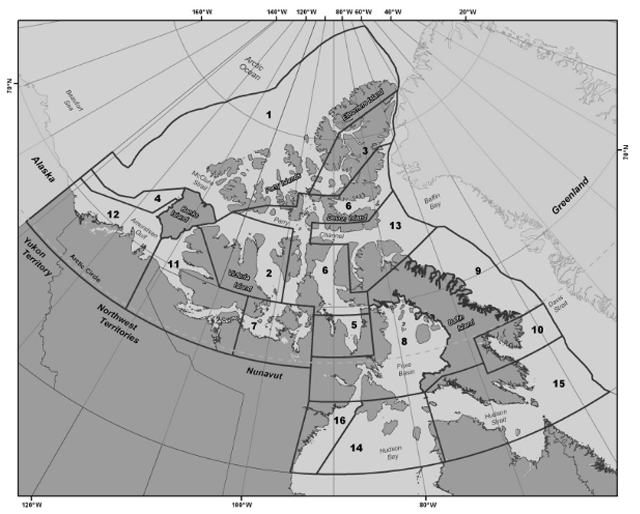
Text description of Figure 3-17a - The Shipping Safety Control zones
This map displays the Shipping Safety Control zones, which cover Canada’s coastal northern waters within the area enclosed by the 60th parallel of north latitude, the 141st meridian of west longitude and the outer limit of the exclusive economic zone.
The Shipping Safety Control zones cover Canada’s coastal northern waters within the area enclosed by the 60th parallel of north latitude, the 141st meridian of west longitude and the outer limit of the exclusive economic zone; however, where the international boundary between Canada and Greenland is less than 200 nautical miles from the baselines of the territorial sea of Canada, the international boundary shall be substituted for that outer limit.
3.8.1 Application
The Vessel Traffic Services Zones Regulations (SOR 2025-275) apply exclusively to the following vessels that are about to enter, leave or proceed within a VTS Zone as described in Schedule 4:
- vessels of 300 gross tonnage or more;
- vessels that are engaged in towing or pushing another vessel, if the combined gross tonnage is 500 gross tonnage or more; and,
- vessels that are carrying as cargo a pollutant or dangerous goods, or vessels that are engaged in towing or pushing such a vessel.
3.8.2 Reporting Requirements
3.8.2.1 Sailing Plan (SP) – 24 hour report
- 24 hours when entering the Northern VTS Zone, or as soon as feasible if the estimated time of arrival of the vessel is less than 24 hours after the time the vessel departed from their last port of call.
- All designators from the Standard VTS Reporting template (Section 3.4 of this publication) that are listed in the Collaborative Vessel Management System form must be answered.
- All time references are to be in Coordinated Universal Time (UTC).
- The Collaborative Voyage Management System must be used to obtain and submit the 24 hour report Sailing Plan. If experiencing difficulty, contact:
Iqaluit MCTS Centre (operational from approximately mid-May to mid- December)
Telephone: +1-867-979-5724
Facsimile: +1-867-979-4264
Telex (Telefax): 063-15529
Telegraphic Identifier: NORDREG CDA
Email: iqanordreg@innav.gc.ca
Les Escoumins MCTS Centre (coverage from approximately mid-December to mid-May)
Telephone: +1-418-233-3483
Facsimile: +1-418-233-3299
Email: iqanordreg@innav.gc.ca
Standard VTS Reporting template designator-specific detailed reporting requirements:
Note: Designators [O], [Q], [T] are not required when entering directly from the Eastern VTS Zone.
Designator [P], this includes:
- Any dangerous goods, listed by total amount of each IMO class on board, or pollutant, that is carried on board the vessel or a vessel being towed or pushed by the vessel, including the quantity
For designator [Q], this includes:
- Anything of the vessel or its machinery, equipment or charts and nautical publications, or circumstances that adversely affect normal navigation.
For designator [R], this includes:
- Any discharge, or threat of discharge, of a pollutant from the vessel into the water, and any damage to the vessel that may result in the discharge or a pollutant from the vessel into the water.
For designator [T], this includes:
- In the case of a Canadian vessel, its authorized representative or owner.
- In the case of a foreign vessel, its Canadian or American agent or owner.
For designator [X], this includes:
- the total amount of oil on board that is for use as fuel or carried as cargo, expressed in cubic metres;
- the expiration date of the Polar Ship Certificate and the name of its issuing authority, if applicable;
- the vessel’s ice class and the name of the classification society that assigned the ice class, if applicable;
- the Certificate of Insurance or Other Financial Security in Respect of Liability for the Removal of Wrecks.
3.8.2.2 Sailing Plan (SP) – other
The following outlines the situations to file a SP, the Standard VTS Reporting template (Section 3.4 of this publication) designator-specific reporting requirements, and the filing times.
3.8.2.2.1 SP – Departing berth in Northern VTS Zone
- More than one hour but not more than two hours before the vessel departs from a berth within the VTS Zone.
- The SP must include the following designators from the Standard VTS Report:
[A], [B], [C] or [D], [H], [I], [L], [N], [O], [P], [Q], [R], [S], [T], [W], [X]
Note: This report is not required when the vessel is moving to another berth in the same port.
Note: Designators [O], [P], [Q], [S], [T], [W], [X] are not required if the corresponding information has not changed since the previous sailing plan report.)
Designator [P], this includes:
- Any dangerous goods, listed by total amount of each IMO class on board, or pollutant, that is carried on board the vessel or a vessel being towed or pushed by the vessel, including the quantity
Designator [Q], this includes:
- Anything of the vessel or its machinery, equipment or charts and nautical publications, or circumstances that adversely affect normal navigation.
Designator [R], this includes:
- Any discharge, or threat of discharge, of a pollutant from the vessel into the water, and any damage to the vessel that may result in the discharge or a pollutant from the vessel into the water.
Designator [T], this includes:
- In the case of a Canadian vessel, its authorized representative or owner;
- In the case of a foreign vessel, its Canadian or American agent or owner;
Designator [X], this includes:
- the total amount of oil on board that is for use as fuel or carried as cargo, expressed in cubic metres;
- the expiration date of the Polar Ship Certificate and the name of its issuing authority, if applicable;
- the vessel’s ice class and the name of the classification society that assigned the ice class, if applicable;
- the expiration date of the Certificate of Insurance or Other Financial Security in Respect of Liability for the Removal of Wrecks.
3.8.2.2.2 SP – Underway following situations
- Immediately before a vessel gets underway within a VTS Zone after the following situations:
- vessel was stranded;
- vessel was stopped as a result of a breakdown in the main propulsion or steering system; and,
- vessel was involved in a collision
- The SP must include the following designators from the Standard VTS Reporting template:
[A], [B], [C] or [D], [I], [L], [N], [O], [P], [Q], [R], [S], [T], [W], [X]
Note: designators [O], [P], [Q], [R], [S], [T], [W] are not required if the information has not changed
Designator [X], this includes:
- a description of the situation
3.8.2.3 Position Report (PR)
The following outlines the situations to file a PR, the Standard VTS Reporting template (Section 3.4 of this publication) designator-specific reporting requirements, and the filing times.
3.8.2.3.1 PR – Entering the Northern VTS Zone
- Immediately after the vessel enters the Northern VTS Zone.
- The PR must include the following designators from the Standard VTS Reporting template:
[A], [B], [C] or [D], [E], [F], [H], [I], [N], [S]
3.8.2.3.2 PR – Daily 1600UTC
- Daily at 1600UTC, if a vessel is underway within the VTS Zone, unless the information required by Regulation 19-1 of Chapter V of SOLAS is being transmitted in accordance with that Regulation (vessel is transmitting required information as per the Long Range Identification and Tracking of Vessels Regulations (LRIT)).
- The PR must include the following designators from the Standard VTS Reporting template:
[A], [B], [C] or [D], [E], [F], [S]
3.8.2.4 Final Report (FR)
The following outlines the situations to file a FR, the Standard VTS Reporting template (Section 3.4 of this publication) designator-specific reporting requirements, and the filing times.
3.8.2.4.1 FR – Arrival at berth in Northern VTS Zone
- On the arrival of the vessel at a berth within the VTS zone.
- The FR must include the following designators from the Standard VTS Reporting template:
[A], [B], [C] or [D], [K]
3.8.2.4.2 FR – Exiting Northern VTS Zone
- Immediately before the vessel leaves the Northern VTS Zone.
- The FR must include the following designators from the Standard VTS Reporting template:
[A], [B], [C] or [D], [K]
3.8.2.5 Other Reports
The following outlines the situations to file Other Reports, the Standard VTS Reporting template (Section 3.4 of this publication) designator-specific reporting requirements, and the filing times.
- As soon as feasible, after the master becomes aware of any of the following, a report must include designators [A], [B], [C] or [D] and [X] from the Standard VTS Reporting template, with [X] containing the details of the situation:
- A fire or explosion on board the vessel;
- The vessel is involved in a collision, a grounding or a striking;
- The vessel makes unforeseen contact with the bottom without running aground;
- There is a defect in the vessel’s hull, main propulsion system, steering system, anchor, and any equipment that is required under the Navigation Safety Regulations, 2020;
- The vessel’s seaworthiness is affected;
- All or part of the vessel’s cargo shifts or falls overboard;
- Another vessel is in apparent difficulty;
- There is an obstruction to navigation;
- An aid to navigation is missing, out of position, malfunctioning, or damaged;
- There are ice or weather conditions that are hazardous to safe navigation;
- A pollutant is in the water;
- The presence of a vessel that may impede the movement of the vessel or any other vessel;
- The following identified risks to the health and well-being of individuals on board the vessel including the crew:
- Category not currently in use
- The following identified risks to marine safety or the marine environment:
- Category not currently in use
3.8.2.6 Deviation Report (DR)
The following outlines the situations to file a DR, the Standard VTS Reporting template (Section 3.4) designator-specific reporting requirements, and the filing times.
- As soon as feasible, after the master becomes aware of any significant changes in any of the information previously reported.
- The DR must include the following designators from the Standard VTS Reporting template:
[A], [B], [C] or [D], and any other designators that have a change of information.
3.8.3 Mackenzie River Areas - Marine Safety Advisory Procedures
For the purpose of enhancing navigation safety on the Mackenzie River, danger areas have been designated and reporting procedures established for vessels in these areas. At any time, vessels can obtain information on any known traffic in the Mackenzie River by contacting MCTS Iqaluit.
At their discretion, vessels transiting the danger zones (1-10) listed below shall broadcast a safety advisory including their position on CH16 to advise other vessels in the area:
- Wrigley Harbour to Horn River
- Downbound traffic reports in at Mile 0 and out at Mile 65.
- Upbound traffic reports in at Mile 65 and out at Mile 0.
- Head of the Line to Fort Simpson
- Downbound traffic reports in at Mile 130 and reports out at Mile 205.
- Upbound traffic reports in at Mile 205 and out at Mile 130.
- Camsell Bend to Jones Landing
- Downbound traffic reports in at Mile 282 and out at Mile 325.
- Upbound traffic reports in at Mile 325 and out at Mile 282.
- Blackwater River to Old Fort Point
- Downbound traffic reports in at Mile 400 and out at Mile 480.
- Upbound traffic reports in at Mile 480 and out at Mile 400.
- Sans Sault Rapids
- Downbound traffic reports in at Mile 620 and out at Mile 645.
- Upbound traffic reports in at Mile 645 and out at Mile 620.
- Ramparts Rapids
- Downbound traffic reports in at Mile 667 and out at Mile 680.
- Upbound traffic reports in at Mile 680 and out at Mile 667.
- Oniak Channel
- Traffic reports in when entering the Oniak Channel from the following channels: Middle Channel, Luker Channel and East Channel.
- Traffic reports out when leaving the Oniak Channel to the following channels: Middle Channel, Luker Channel and East Channel.
- East Channel – Inuvik to Tununuk
- Downbound traffic reports when leaving Inuvik and out when either entering Oniak Channel or at Mile 1040.
- Upbound traffic for Inuvik reports in at Mile 1040 or when entering from the Oniak Channel and reports arrival at Inuvik.
- East Channel – Kittigazuit
- Downbound traffic reports in at Mile 1070 and out at the fairway buoy at Mile 1081.
- Upbound traffic reports in at the fairway buoy at Mile 1081 and out at Mile 1070.
Any other restricted channels in the Mackenzie Delta at their own discretion.
All vessels should maintain a continuous radio watch on the Western Arctic Emergency and Calling Frequency, 5803 kHz (SSB), from the time that they reach the first reporting point previous to entering a danger area until the time that they report clear of the danger area.
The Safety Advisory calls should consist of the following information:
- name of towing vessel and number of barges in the tow and whether riding high or low;
- direction of voyage i.e. northbound, southbound, etc.;
- danger zone;
- mileage;
- time; and
- remarks.
Example:
All Stations, All Stations this is Kitikmeot, southbound with 6 barges riding high, entering Area 6 at Mile 680, 1030 Local estimating Mile 660 at 1530 local over
3.9 Great Lakes Basin waterways
The waters of the Great Lakes, their connecting and tributary waters and the waters of the St. Lawrence River as far as the lower exit of the St. Lambert Lock at Montréal, Québec.
- Vessels engaged on a voyage in the Great Lakes Basin, must be fitted with a VHF radio or a portable VHF radio that is capable of DSC, if the vessel is:
- More than 8m in length,
- Carrying more than 6 passengers, or
- A towboat, whose tow, excluding the tow line, is 20m or more in length.
- In addition to the above requirements, the following vessels must be fitted with an additional VHF radio:
- A vessel 300 gross tonnage or more, and
- A passenger vessel that is 20m or more in length and engaged on a voyage other than a sheltered waters voyage.
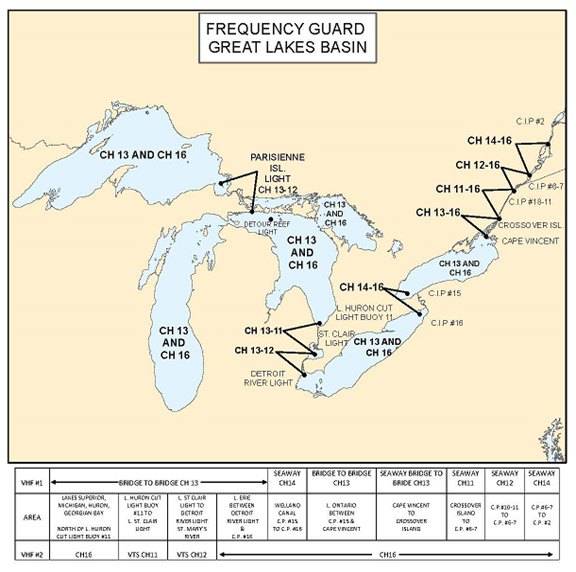
Text description of Figure 3-17b - Waters of the Great Lakes Basin and St. Lawrence River
This map shows the waters of the Great Lakes Basin, as well as the St. Lawrence River as far east as Montréal, and is used to show the radio frequencies which should be monitored by mariners dependent upon their vessel’s location. Throughout the Great Lakes themselves, mariners should ensure that VHF channel 13 and VHF channel 16 are monitored on their vessel’s bridge. The table shows the changes in monitoring requirements within the different high-level VTS zones.
3.9.1 Frequency Watch – Great Lakes Basin waterways
Navigation Safety Regulations, 2020, Schedule 4 outlines the VHF Radiotelephone Channels for Listening Watches and Navigation Safety Calls within the Great Lake Basin waterways. The transmission power of a navigation safety call on Channel 13 within the Great Lakes Basin must not exceed 1W except in the following cases, when that power must not exceed 25W:
- In case of an emergency
- The vessel being called to does not respond
- A broadcast in blind situation such as when the vessel is rounding a bend in a channel.
| Location | Monitor | Remarks |
|---|---|---|
| CIP #2 to CIP #6-7 (Seaway Beauharnois) |
Seaway Ch14 and Ch16 | Ch13 Bridge-to-Bridge exemption through this area. |
| CIP #6-7 to CIP #10-11 (Seaway Eisenhower) |
Seaway Ch12 and Ch16 | Ch13 Bridge-to-Bridge exemption through this area. |
| CIP #10-11 to Crossover Island (Seaway Iroquois) | Seaway Ch11 and Ch16 | Ch13 Bridge-to-Bridge exemption through this area. |
| Crossover Island to Cape Vincent (Seaway Clayton) | Bridge Ch13 and Ch16 | Ch13 serves as Bridge in this area. Seaway Clayton on Ch12 through this area. |
| Cape Vincent to mid Lake Ontario (Seaway Sodus) | Bridge Ch13 and Ch16 | Seaway Sodus also on Ch12 through this area. |
| Mid Lake Ontario to CIP #15 (Seaway Newcastle) |
Bridge Ch13 and Ch16 | Seaway Newcastle operates on Ch11 through this area. |
| CIP #15 to CIP #16 (Welland Canal) |
Seaway Ch14 and Ch16 | Ch13 Bridge-to-Bridge exemptions through this area. |
| CIP #16 to Long Point Lake Erie (Seaway Long Point) | Bridge Ch13 and Ch16 | Seaway Long Point on Ch11. |
| Long Point to Detroit River Light (Lake Erie) |
Bridge Ch13 and Ch16 | Sarnia MCTS Centre operate on Ch12. |
| Detroit River Light to Lake St. Clair Light |
Bridge Ch13 and MCTS Centre Ch12 |
Sarnia MCTS Centre will monitor Ch16 on behalf of vessels. |
| Lake St. Clair Light to Lake Huron Cut Light Buoy “11” |
Bridge Ch13 and MCTS Centre Ch11 |
Sarnia MCTS Centre will monitor Ch16 on behalf of vessels. |
| Lake Huron Cut Light Buoy “11” to De Tour Reef Light including Cove Island (Lake Huron and Georgian Bay) |
Bridge Ch13 and Ch16 | Sarnia MCTS Centre operate on Ch11 Lake Huron. |
| De Tour Reef Light to Île Parisienne Light (St. Mary’s River) |
Bridge Ch13 and Ch12 | USCG Sault Ste Marie (SOO Traffic) will monitor Ch16 on behalf of vessels. |
| Île Parisienne Light through Lakes Superior/Michigan |
Bridge Ch13 and Ch16 | - |
Notes:
- Portable VHF equipment may be accepted to meet the Ch13 requirement when a ship is required by the Navigation Safety Regulations, 2020, to fit only one radiotelephone installation.
- In summary, vessels shall monitor Ch13 Bridge-to-Bridge continuously except in the exempted areas of St. Lambert to Crossover Island and in the Welland Canal where the appropriate Seaway channel must be guarded.
- Channel 16 shall also be guarded throughout the Great Lakes Basin except from Detroit River Light to Lake Huron Cut Lighted Buoy “11” (Sarnia VTS zone) and from DeTour Reef Light to Île Parisienne Light (St. Mary’s River). Since vessels will be guarding Ch13 and the VTS frequency through the zones, watch on Ch16 will be maintained by MCTS Sarnia for the Sarnia VTS zone and by USCG Sault Control for the DeTour Reef Light to Île Parisienne zone on behalf of vessels in transit.
- While the Ch13 Bridge-to-Bridge guard is to be maintained continuously (except in exempted waters) the watch on Ch16 may be relinquished when reporting at a CIP or exchanging traffic with any station of the maritime mobile service on an appropriate working frequency.
- When wishing to contact a Harbour, Bridge or Pilotage authority initial contact should be made on the appropriate working channel as directed.
- Information contained in the chart and narrative is based on the latest information at time of printing.
3.9.2 St. Lawrence Seaway Management Corporation
As per the Canada Marine Act, Section 99, vessels exceeding 300 gross registered tonnes that are navigating the deep waterway between the port of Montréal and the Great Lakes that is constructed and maintained pursuant to the Agreement between Canada and the United States providing for the development of navigation and power in the Great Lakes-St. Lawrence Basin, dated March 19, 1941, including the locks, canals and facilities between the port of Montréal and Lake Erie and generally known as the St. Lawrence Seaway, must conform to the regulations and provisions found within the Seaway Handbook.
The provisions within the Seaway Handbook are subject to change. Mariners are recommended to subscribe to the free Seaway Handbook update service.
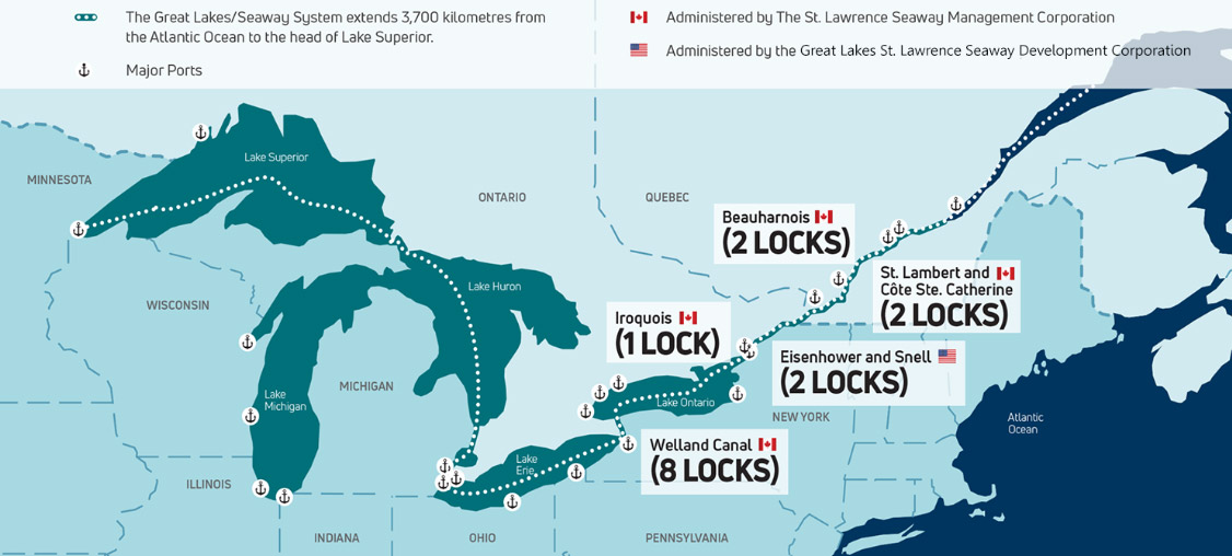
Text description of Figure 3-17c - Great Lakes/St. Lawrence Seaway system
This map shows the Great Lakes/St. Lawrence Seaway system from the Atlantic Ocean to the head of Lake Superior, including the St. Labert and Cote Ste. Catherine locks, the Beauharnois locks, the Eisenhower and Snell locks, the Iroquois locks and the Welland Canal locks.
3.9.3 Sarnia VTS Zone and Areas
Sarnia is divided into two VTS practices: Sarnia VTS Zone (Mandatory) and Sarnia VTS Areas (Voluntary).
3.9.3.1 Sarnia VTS Zone
Sarnia Vessel Traffic Services zone is comprised of the waters from Lake Huron Cut light buoy "11" to buoys 1 in the East and West Outer Channels in Lake Erie.
NUMERICAL CIPs identify mandatory calling-in-points under the Navigation Safety Regulations, 2020.
3.9.3.2 Sarnia VTS Areas
Sarnia Vessel Traffic Services Areas are comprised of Canadian waters in Lake Huron from DeTour Reef light to Lake Huron Cut light buoy "11", and Canadian waters in Lake Erie from East and West Outer Channel buoys "1" to Long Point light. Ships in these areas are required to guard the International Distress, Safety and Calling Frequency 156.800 MHz (Channel 16).
ALPHABETICAL CIPs identify voluntary calling-in-points in the Sarnia Vessel Traffic Services Areas.
Figure 3-18 - Sarnia VTS Zone and Area
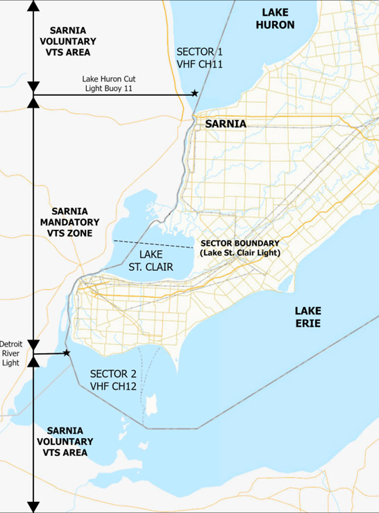
Text description of Figure 3-18 - Sarnia VTS Zone and Area
This map illustrates the waters of southern Lake Huron, the St. Clair River, Lake St. Clair, the Detroit River and western Lake Erie, and the Vessel Traffic Services (VTS) Zone and VTS Area to which the St. Clair and Detroit River Navigation Safety Regulations apply. These VTS Regulations are administered by the Canadian Coast Guard’s Marine Communications and Traffic Services (MCTS) Centre located at Sarnia Ontario. Above Lake Huron Cut Light Buoy 11 is the Sarnia Voluntary VTS Area, part of Sector One, and vessels report on VHF Channel Eleven (VHF CH 11), and this is indicated on the map. From this point southward to the sector boundary at Lake St. Clair Light, in the middle of Lake St. Clair, is the Sarnia Mandatory VTS Zone, Sector One. From Lake St. Clair Light southward to the Detroit River Light – where the Detroit River meets Lake Erie – is the Sarnia Mandatory VTS Zone Two. Here, and in the Sarnia Voluntary zone in western Lake Erie, vessels report on VHF Channel Twelve (VHF CH 12), and this is also indicated on this map.
3.9.3.3 Application
Within the St. Clair and Detroit Rivers, mariners should be guided by the traffic reporting provisions of the Navigation Safety Regulations, 2020.
- The section of the St. Clair River and Detroit River apply to:
- All vessels in Canadian waters between Lake Erie and Lake Huron; and
- All Canadian vessels in the waters of the United States between buoy “1” of the East Outer and West Outer Channels at the Lake Erie entrance to the Detroit River and Lake Huron Cut Lighted Buoy “11” and including the Rouge River and Short Cut Canal from Detroit Edison Cell Light “1” to the head of navigation.
- Every vessel transiting the area must maintain a continuous listening watch and make reports to MCTS Sarnia, with the exception:
- Vessels not required to be fitted with a VHF radio installation or VHF radio telephone, as described in Part 2 of NSR, 2020
- The Detroit River restrictions and overtaking prohibitions do not apply to:
- A vessel engaged in icebreaking, search and rescue, or servicing aids to navigation that are:
- A government vessel
- Owned by and in the service of the government of the United States, or,
- In the exclusive possession of the government of the United States; or,
- A vessel engaged in river or harbour improvements, if it is operated in a safe and prudent manner and other vessels have been warned of those operations.
- The waters between the St.Clair/Black River Junction Light and Lake Huron Cut Lighted Buoy “1” constitute an area of alternating one-way traffic with navigation requirements set forth in NSR, 2020 Part 3, and apply to:
- A power-driven vessel that is 55m or more in length;
- A vessel that is 20m or more in length propelled only by sails;
- A towboat; or
- A floating plant.
3.9.3.4 Sailing Plan (SP)
The following outlines the situations to file a SP, the Standard VTS Reporting template (Section 3.4 of this publication ) designator-specific reporting requirements, and the filing times. Table 3-39 details which VHF frequencies can be used in VTS sectors.
3.9.3.4.1 SP – Entering Sarnia VTS Zone and Areas
- At least 15 minutes before the vessel enters the Sarnia VTS Zone and Areas.
- The SP must include the following designators from the Standard VTS Reporting template:
[A], [B], [C] or [D], [H], [I], [N], [P], [Q], [R], [T]
3.9.3.4.2 SP – Manoeuvre detrimental to safe navigation
- At least 15 minutes before the vessel begins a manoeuvre in a VTS zone that may be detrimental to safe navigation.
- The SP must include the following designators from the Standard VTS Reporting template:
[A], [B], [C] or [D], [X]
Designator [X], this includes:
- a description of the intended manoeuvre
3.9.3.4.3 SP – Departing Berth in Sarnia VTS Zone and Areas
- At least 15 minutes before the vessel departs from a berth within a VTS zone.
- The SP must include the following designators from the Standard VTS Reporting template:
[A], [B], [C] or [D], [H], [I], [N], [P], [Q], [R], [T]
3.9.3.4.4 SP – Underway following situations
- Immediately before a vessel gets underway within a VTS Zone after the following situations:
- vessel was stranded;
- vessel was stopped as a result of a breakdown in the main propulsion or steering system; and,
- vessel was involved in a collision
- The SP must include the following designators from the Standard VTS Reporting template:
[A], [B], [C] or [D], [I], [L], [N], [O], [P], [Q], [R], [S], [T], [W], [X]
Note: designators [O], [P], [Q], [R], [S], [T], [W], are not required if the information has not changed.
Designator [X], this includes:
- a description of the situation.
3.9.3.5 Position Report (PR)
The following outlines the situations to file a PR, the Standard VTS Reporting template (Section 3.4 of this publication) designator-specific reporting requirements, and the filing times. Table 3-39 details which VHF frequencies can be used in VTS sectors.
3.9.3.5.1 PR – Calling-in-Point
- Upon arrival at a calling-in-point as described within the Sarnia VTS Zone and Areas section (see section 3.9.3 of this publication for details).
- The PR must include the following designators from the Standard VTS Reporting template:
[A], [B], [C] or [D], [N]
3.9.3.5.2 PR – Manoeuvre detrimental to safe navigation completed
- As soon as feasible after the manoeuvre in a VTS zone that may be detrimental to safe navigation.
- The PR must include the following designators from the Standard VTS Reporting template:
[A], [B], [C] or [D], [N]
3.9.3.5.3 PR – Upon departing berth in Sarnia VTS Zone and Areas
- Immediately before the vessel departs from a berth within a VTS zone.
- The PR must include the following designators from the Standard VTS Reporting template:
[A], [B], [C] or [D], [N]
3.9.3.6 Final Report (FR)
The following outlines the situations to file a FR, the Standard VTS Reporting template (Section 3.4 of this publication) designator-specific reporting requirements, and the filing times. Table 3-39 details which VHF frequencies can be used in VTS sectors.
3.9.3.6.1 FR – Arrival at Berth in Sarnia VTS Zone and Areas
- On the arrival of the vessel at a berth within a VTS zone.
- The FR must include the following designators from the Standard VTS Reporting template:
[A], [B], [C] or [D], [K]
3.9.3.6.2 FR – Exiting Sarnia VTS Zone and Areas
- Immediately before the vessel leaves a VTS Zone.
- The FR must include the following designators from the Standard VTS Reporting template:
[A], [B], [C] or [D], [K]
Note: This report is not required if the vessel enters any other VTS Zone.
3.9.3.7 Other Reports
The following outlines the situations to file Other Reports, the Standard VTS Reporting template (Section 3.4 of this publication) designator-specific reporting requirements, and the filing times. Table 3-39 details which VHF frequencies can be used in VTS sectors.
- As soon as feasible, after the master becomes aware of any of the following, a report must include designators [A], [B], [C] or [D] and [X] from the Standard VTS Reporting template, with [X] containing the details of the situation:
- A fire or explosion on board the vessel;
- The vessel is involved in a collision, a grounding or a striking;
- The vessel makes unforeseen contact with the bottom without running aground;
- There is a defect in the vessel’s hull, main propulsion system, steering system, anchor, and any equipment that is required under the Navigation Safety Regulations, 2020;
- The vessel’s seaworthiness is affected;
- All or part of the vessel’s cargo shifts or falls overboard;
- Another vessel is in apparent difficulty;
- There is an obstruction to navigation;
- An aid to navigation is missing, out of position, malfunctioning, or damaged;
- There are ice or weather conditions that are hazardous to safe navigation;
- A pollutant is in the water;
- The presence of a vessel that may impede the movement of the vessel or any other vessel;
- The following identified risks to the health and well-being of individuals on board the vessel including the crew:
- Category not currently in use
- The following identified risks to marine safety or the marine environment:
- Category not currently in use
3.9.3.8 Deviation Report (DR)
The following outlines the situations to file a DR, the Standard VTS Reporting template (Section 3.4) designator-specific reporting requirements, and the filing times. Table 3-39 details which VHF frequencies can be used in VTS sectors.
- As soon as feasible, after the master becomes aware of any significant changes in any of the information previously reported.
- The DR must include the following designators from the Standard VTS Reporting template:
[A], [B], [C] or [D], and any other designators that have a change of information.
3.9.3.9 Sarnia VTS Zone and Areas with Calling-in-Points
| Sector | Boundaries |
|---|---|
| 1 | The waters of Lake Huron, the St. Clair River and Lake St. Clair from a line running 090° - 270° True through De Tour Reef light, 45°56’54”N 083°54’12”W to a line joining Lake St. Clair light 42°27’54”N 082°45’18”W and Lake St. Clair light buoy "24", 42°27’53”N 082°45’03”W. |
| 2 | The waters of Lake St. Clair, the Detroit River and Lake Erie from a line joining Lake St. Clair light, 42°27’54”N 082°45’18”W and Lake St. Clair light buoy "24", 42°27’53”N 082°45’03”W to a line running 152° True from Long Point light 42°32’55”N 080°02’57.4”W in Lake Erie. |
| Sector | Identifier | Channel | Frequency (MHz) |
|---|---|---|---|
| 1 | "Sarnia Traffic" | 11 | 156.55 |
| 2 | "Sarnia Traffic" | 12 | 156.6 |
Note: Sarnia Traffic monitors navigation in the VTS zone and areas using RADAR and AIS.
| Number | Sector | Name | General Description and Conditions | Geographic Description |
|---|---|---|---|---|
| A | 1 | De Tour | At De Tour Reef light for vessels transiting St. Mary's River. |
For vessels transiting St. Mary's River, a line running 090°-270° True through 45°56’54”N 083°54’12”W. |
| A | 1 | Cordwood Point | At Cordwood Point light buoy "1" for vessels transiting to or from Lake Michigan. These vessels should specify Cordwood Point. |
For vessels transiting to or from Lake Michigan, a line joining 45°56’54”N 083°54’12”W and 45°40’53”N 84°18’05”W. |
| B | 1 | Great Duck Island | A line joining Great Duck Island light and Presque Isle light. | A line running from 45°38’30”N 082°57’48”W to 45°21’24”N 083°29’30”W. |
| C | 1 | Cove Island | At Cove Island light for vessels en route to or from Georgian Bay. |
A line running 000° True from 45°19’37”N 081°44’07”W Call Sarnia MCTS on Ch26. |
| D | 1 | Harbor Beach Point Clark | Mariners should specify Point Clark when following Georgian Bay courses and Harbor Beach at all other times. | A line joining: 43°50’42”N 082°37’54”W and 44°04’22.1”N 081°45’25.6”W. |
| 1 | 1 | 30 minutes north of Lake Huron Cut light buoy “11” | 30 minutes north of Lake Huron Cut lighted buoys “11” and “12” (downbound only). | - |
| E | 1 | Lake Huron Cut Light buoy “11” | Lake Huron Cut light buoy “11”. | A line running 090°-270° True through 43°05’25”N 082°24’38”W. |
| 2 | 1 | Lake Huron Cut Light “7” | Lake Huron Cut light “7” (downbound only). |
A line running 090°-270° True through 43°03’36”N 082°25’06”W. |
| 3 | 1 | Lake Huron Cut Light buoy “1” | At Lake Huron Cut light buoy “1” (upbound only). | A line running 090°-270° True through 43°00’37”N 082°24’53”W. |
| 4 | 1 | Black River | At St. Clair / Black River Junction Light. | On north shore of river entrance 42°58’24”N 082°25’12”W. |
| 5 | 1 | Stag Island Upper Light |
At Stag Island Upper Light (upbound only). |
A line running 090° True from 42°54’25”N 082°27’57.5”W. |
| 6 | 1 | Salt Dock | Marine City Salt Dock light. | A line running 110° True from 42°41’16.8”N 082°30’20.5”W. |
| 7 | 1 | Light 23 | Grande Point light "23" (downbound only). |
A line joining: 42°35’07”N 082°33’23.5”W and 42°35’04”N 082°33’10”W. |
| 8 | 1 | Light 2 | A line joining St. Clair Flats Canal light “2” and St. Clair Cutoff Pier light “X32/1" (upbound only). | A line running from 42°31’06”N 082°41’12”W and 42°30’54”N 082°41’08”W. |
| 9 | Change | Lake St. Clair light | Lake St. Clair Light. | A line running from 42°27’54”N 082°45’18”W and 42°27’53”N 082°45’03”W. |
| 10 | 2 | Station Belle Isle | Belle Isle light (downbound only). |
A line running 150° True from 42°20’24”N 082°57’36”W. |
| 10A | 2 | Rouge River | 20 minutes from entering or leaving the Rouge River or Shortcut Canal. | - |
| 10B | 2 | Rouge River | Immediately before entering or leaving the Rouge River or Shortcut Canal. | A line running from 42°16’26”N 083°06’36”W and 42°16’31”N 083°06’33.5”W. |
| 11 | 2 | Grassy Island light | Grassy Island light. | A line running 090°-270° True through 42°13’30”N 083°08’00”W. |
| 12 | 2 | Detroit River light | Detroit River light. | A line running 090°-270° True through 42°00’01”N 083°08’30”W. |
| F | 2 | Southeast Shoal | At Southeast Shoal light. | A line from 41°54’33”N 082°30’36”W to 41°49’35”N 082°27’47”W thence to 41°32’12”N 082 42’42”W. |
| G | 2 | Long Point | A line joining Long Point light to the south shore of Lake Erie. | A line running 152° True from 42°32’55”N 080°02’58”W to 42°14’35”N 079°49’44”W. |
All times shall be given in UTC, unless transiting only in one Time Zone. Sarnia VTS Zone and Areas operate in Eastern Standard Time (EST) or Eastern Daylight Saving Time (EDT).