Turkey Lakes watershed study site: geology and geomorphology
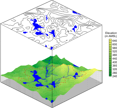
Elevation at the lowermost stream gauging station is 340 m above mean sea level. The highest point is atop "Batchawana Mountain" (630 m) on the northern edge of the basin giving an overall relief of 290 m (Figure 1).

Figure 1: Long Description
Elevation map of the Turkey Lakes Watershed. The highest point is atop "Batchawana Mountain" (630 m) on the northern edge of the basin giving an overall relief of 290 m.

Planar view of a Topographic Map of the TLW Contours
This amount of relief is large for calibrated watersheds in eastern Canada.
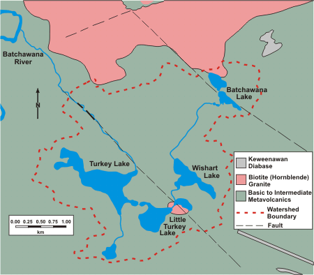
The TLW is almost entirely underlain by Precambrian silicate greenstone (i.e. a metamorphosed basalt composed mainly of horneblende, plagioclase, chlorite and epidote) with only small outcrops of more felsic igneous rock occurring north of Batchawana Lake and near the main inflow to Little Turkey Lake (see map of bedrock geology). Regional fault systems tending approximately NW-SE and SW-NE have exerted some control over water drainage giving the rather angular drainage pattern shown in the map.
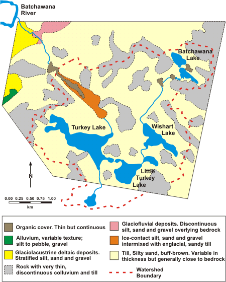
The entire region was glaciated approximately 12,000 years ago. A thin, discontinuous two-component glacial till overlies the bedrock (see map of surficial geology). Till thickness varies from less than 1 m with frequent exposure of bedrock at high elevations to 1-2 m on average at lower elevations. There are some occurrences of extremely deep till (up to 70 m) where valleys in the bedrock were entirely filled by the glaciers. Till mineralogy is more felsic than the underlaying bedrock showing that the material was likely derived from granitic rocks north of the basin. In addition, the till contains a small amount (0-2%) of calcium carbonate which strongly influences the acidity/alkalinity of drainage waters. The upper till component is an ablation till. It is generally very thin (<1 m thick), has high water permeability (10-3 cm/sec) and low carbonate content. The lower component is a basal till of variable thickness with lower permeability (10-5 cm/sec) and higher carbonate content.
The most frequently encountered soil types on upland sites are Ferro-Humic and Humo-Ferric Podzols (Canadian soil classification system).
Bedrock Geology of the Turkey Lakes Watershed

Map 1: Long Description
Bedrock Geology of the Turkey Lakes Watershed. The TLW is almost entirely underlain by Precambrian silicate greenstone with only small outcrops of more felsic igneous rock occurring north of Batchawana Lake and near the main inflow to Little Turkey Lake.
Surficial Geology of the Turkey Lakes Watershed

Map 2: Long Description
Surficial Geology of the Turkey Lakes Watershed. A thin, discontinuous two-component glacial till overlies the bedrock. Till thickness varies from less than 1 m with frequent exposure of bedrock at high elevations to 1-2 m on average at lower elevations.