
Causes of flooding
In this Section:
Introduction
Most flooding occurs when the volume of water in a river or stream exceeds the capacity of the channel. Flooding also takes place along lake and coastal shorelines, when higher than normal water levels inundate low-lying areas.
Numerous factors affect streamflow, and therefore the potential for flooding. Most important are the amount and type of precipitation, the nature and condition of the drainage basin, and climate.
Precipitation
All rivers are subject to fluctuations in flow. During a rainstorm, the amount, intensity, duration, area of storm, and path of the storm all influence the runoff reaching the stream. The amount, intensity, and duration of storms affect the ability of the land to absorb the precipitation and therefore affect the rate of runoff. The area and path of the storm relate to the area of the basin receiving rainfall, which in turn, represents the area contributing runoff. The area and the runoff rate determine the volume of water that will pass a given point downstream.
Drainage basins
The shape, size, soil type, and topography of the drainage basin are other factors affecting the quantity of water reaching the stream. These factors are usually constant. However, the absorptive or shedding properties of the soil vary with vegetation cover, season, and previous rainfall.
In the case of reforestation and revegetation, the rate at which surface water flows to the main channel may be slowed, and hence the runoff is spread over a longer period. In addition, the passage of water tends to be retarded in basins with many natural storage areas, such as lakes and wetlands, and even those with artificially created storage. Consequently, smaller peak flows are produced than in basins without these modifying influences. The best North American example of a basin with large natural storage is that of the St. Lawrence River, which has the Great Lakes in its headwaters.
Climate
Climate has an important influence on the relationship between precipitation and runoff. Frost makes most soil impenetrable if the soil contains moisture. In northern latitudes, the winter season, during which a large part of the year's precipitation is stored in the form of snow, is often followed by sudden melting, with much of the runoff flowing quickly over frozen ground to reach streams. Also, the heavy ice formation on rivers influences flooding, particularly on the northward flowing rivers. Climate controls the strength of an ice cover in winter, and its manner of breakup, which governs the severity of ice jamming.
Snowmelt Runoff
During the Canadian winter, most of the precipitation is simply stored as snow or ice on the ground. During the springmelt, huge quantities of water are released, which explains our heavy spring runoff and flooding. This is called freshet.
Snowmelt runoff floods are the most common type of flooding in Canada. These floods generally occur in the spring but will also occur during sudden winter thaws. Heavy runoff results from the rapid melting of the snow under the combined effect of sunlight, winds, and warmer temperatures. When the ground is frozen, the water produced by the melting snow is unable to penetrate and runs off over the ground surface into streams and lakes. The amount of surface runoff is usually within the capacity of the channel to drain off without flooding. However, if there is an above-average snow depth, a sudden thaw, or both, then the potential for high volumes of runoff and subsequent flooding increases. The situation can become of even greater concern if the rising snowmelt runoff is compounded by runoff from heavy rainfall. The later the thaw, the more likely this situation will prevail. Since the climatic factors influencing the rate of snowmelt are often widespread, snowmelt runoff flooding conditions can exist over vast areas.
Rainfall
Flash floods can be extremely dangerous. Unanticipated, they usually happen on small watersheds as a result of a torrential downpour, often caused by heavy thunderstorm activity.
A flash flood is characterized by the occurrence of the peak of the flood within six hours of the onset of rainfall. The flood conditions develop rapidly because the rainfall is so heavy the ground is incapable of absorbing the water quickly enough, resulting in a very high runoff rate. The events are generally locally intense and damage is usually restricted to a limited area. Large rivers remain unaffected, while smaller streams can overtop their banks, even in a drought year.
Several notable flash flood events have occurred in Canada. During a storm at Harrow, Ontario, in July of 1989, over 400 millimetres of rain fell in 30 hours. In Quebec, a spectacular flash flood struck Montreal on July 14, 1987. The most intensive rainfall in Canadian history happened on May 30, 1961, at Buffalo Gap, Saskatchewan. More recently, severe prairie convective thunderstorms have produced some of the highest rainfall rates and largest local floods in Canada (e.g., in Calgary, Edmonton and Lethbridge, Alberta).
Source: Adapted from Handbook on the Principle of Hydrology, D.M. Gray, ed.

Ice Jams
Ice jams are a major cause of flooding in Canada. In fact, for most Canadian rivers, the annual peak water levels are due to ice jams. These jams result from the accumulation of ice fragments that build up to restrict the flow of water and then act as a temporary obstruction. Jams form during both the freeze-up and breakup periods, but it is usually the breakup jams that have the greater flooding potential. While national figures are not available, on a provincial scale, data for the Saint John River basin in Atlantic Canada indicate that over two thirds of total provincial flood damage costs are due to ice-related events. The section on "Flood events in Canada" contains descriptions of ice jam flooding of the Saint John, St. Lawrence and Winisk rivers.
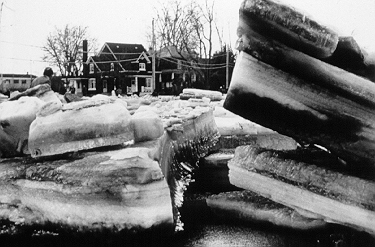
During the freeze-up period, ice forms on the river surface beginning at the banks. Ice crystals may also develop within the river as frazil ice, in open turbulent water under supercooled conditions, that is, the temperature of the water is slightly below 0°C. It is very common in rapids. The ice crystals tend to coalesce and accumulate, and may become attached to the underside of the ice cover or to the river bed as anchor ice.
The coalescing frazil can also form flocs, which float to the surface when stream turbulence is reduced or when the buoyancy of a growing mass exceeds downward turbulence. The flocs continue to agglomerate and produce pans, which, in turn, may freeze together creating ice floes. Frazil pans and flocs are major components in the formation of a river's initial ice cover. In tranquil reaches, this cover is a mere surface layer of ice floes and pans, but elsewhere it can be several layers thick.
Ice jams during the freeze-up period usually form where floating ice slush or blocks encounter a stable ice cover. The beginning of the ice jam is referred to as the toe and the upstream end as the head. The stable ice is frozen to the banks or is restricted from moving by the channel configuration. Generally, incoming ice fragments either submerge and deposit under the stable ice cover or pile up behind it, or both. There are, however, certain features that, in conjunction with ice cover, or on infrequent occasions, alone, enhance the probability of ice jam formation: bridge piers, islands, bends, shallows, slope reductions, and constrictions.
During breakup in the spring, or during winter thaws, an ice jam results from the accumulation of ice from the breakup of the upstream ice cover. A rise in water levels may result from the spring snowmelt, or common to the southern and Atlantic parts of Canada, a sudden midwinter thaw. Midwinter thaws are often accompanied by substantial rainfall, resulting in a rapid increase in water levels and severe ice jams.
The ice cover may be broken in a major fashion due to uplift pressures exerted by rapidly rising water levels. This causes "hinge cracks," or longitudinal fracture lines parallel to the shores. The cover breaks down into smaller pieces after being set in motion by the flow and impacting with channel boundaries or other sections of ice cover.
Ice jams cause flooding because of two main features. First, ice jam thickness can be considerable, amounting to several metres. Secondly, the underside of the ice cover is usually very rough. Under open water conditions, the only frictional resistance retarding the flow of the water is the streambed. The rougher the streambed, the greater the depth required to pass a given discharge. With an ice jam in place, the additional ice and very rough lower surface retard flow. Therefore, the flow depth has to be much greater than for open water.
If the depth of water necessary to float the jam is added to the depth required to maintain the discharge, it can be seen that extremely high water levels can occur, even at relatively small discharges.
Another potentially damaging condition closely related to ice jam flooding is the surging flow produced by the sudden release of a major ice jam. Flow surges can move as fast as 10 metres per second, or 36 kilometres per hour, which implies that the water level could rise rapidly, allowing little time for emergency measures. Moreover, the velocity of water and floating ice can also be very high, more than 5 metres per second, or 18 kilometres per hour, with the potential for serious erosion or ice impact damages.
Anecdotes
Insight, Alberta Public Safety Services: Spring breakup in Fort McMurray, Alberta, draws crowds each year but the possibility of flooding caused by ice jams is an annual worry.
Betty Brown, Vars, Ontario: As a child growing up on a farm beside the Becaguimec River In New Brunswick, I remember my father in the spring getting the tractor and hauling the outhouse and pigpen away from the river. Over the years we lost a good many outhouses.
During the breakup, we would hear a rumbling noise that sounded like thunder. The ice practically grazed the side of our house, Some of the chunks were the size of our house. One year, my dog got stranded on the ice and my mother rescued him. Daily my brother and I would watch for "strange" stuff. We would see pots and pans, balls and bats, inner tubes, uprooted trees go by... Living in the country, spring breakup is a highlight of the year.
See Also:
Catastrophic Outbursts
Outburst floods are common in western Canada. Lakes dammed by glaciers or moraines suddenly drain and tonnes of water, mud and debris are released.
Outbursts from glacier-dammed lakes are known as "jökulhlaups," an Icelandic term. An outburst flood typically occurs when the water level becomes high enough to actually float the ice or when a small channel forms under the ice and causes rapid melting, thus expanding the channel. Another common mechanism is overtopping of the ice dam and the rapid thermal and mechanical erosion of a channel, leading to catastrophic drainage. In all cases, the new channel increases rapidly in size and releases the lake water quickly. The release of water is often sudden and catastrophic. Many glacier-dammed lakes have been known to empty and refill a number of times. The typical discharge pattern of outburst floods is illustrated in this hydrograph.

Outbursts from moraine-dammed lakes are less common but can be just as destructive. In the case of these lakes, water overtops and cuts through the moraines. There is also the possibility, with recent lakes, of failure of the dam caused by seepage through the moraine once the internal ice core has melted away.
Floodwaters from glacier- and moraine-dammed lakes can pick up large quantities of sediments and transform into destructive debris flows. This water-saturated, bouldery debris rushes down valley, ripping sediments and trees from the valley floor.
Many jökulhlaups have occured in western Canada in recent years. A description of a jökulhlaup at Kicking Horse Pass, British Columbia is presented in the section on "Flood events in Canada". The locations of others, including those from Hazard Lake in the St. Elias Mountains and from Tulsequah, Flood, Summit and Ape lakes in the Coast Mountains, are represented on the following map.

Coastal Storms
Many Canadians living along the shores of major lakes, such as the Great Lakes, or along Canada's coasts have experienced flooding and property damage as a result of high wind and wave action, or the interaction between high estuarine flows and tides. Shoreline flooding may be caused by storm surge or seiches, often occurring simultaneously with high waves.
Any body of water has a set of natural periods of oscillation at which it is easy to set up motions, which are called seiches. The periods of these seiches, which are dependent on the water depth and the horizontal dimensions of the body of water, can range from several minutes to several hours. They occur commonly in enclosed or partially enclosed basins and are usually the result of a sudden change, or a series of intermittent-periodic changes, in atmospheric pressure or wind velocity. The period of oscillation of a seiche depends on the causative force which sets the water basin in motion and the natural or free oscillating period of the basin. For example, when the wind ceases, the effort of the water to return to equilibrium may create an oscillation at a period unique to the region of occurrence.
The appearance of these seiches can be simulated by tilting a basin partially filled with water and then setting it down on a level surface. The water will slosh back and forth at a period determined by the size and shape of the basin. The maximum amplitude of a seiche in a closed basin occurs at the ends; the point of no vertical change occurs at the middle.

Storm waves from Lake Erie wash over a beach and picnic area at Point Pelee National Park, Ontario (Public Works and Government Services Canada / Richard Vroom, 1976)
Surges are caused by sudden changes in atmospheric pressure and by the wind stress accompanying moving storm systems. Storm systems are significant because of their frequency and potential for causing abnormal water levels at coastlines. In many coastal regions, maximum storm surges are produced by severe tropical hurricanes. Determination of water elevations during storms is a complex problem involving interaction between wind and water, and differences in atmospheric pressure. Winds are responsible for the largest changes in water level due to surge. A wind blowing over a body of water exerts a horizontal force on the water surface and induces a surface current in the general direction of the wind. These currents are impeded in shallow water areas, causing the water level to rise downwind while at the windward side of the basin the water level falls. The term "storm surge" is used to indicate departure from normal water level due to the action of storms. The term "wind setup" is often used to indicate rises in lakes, reservoirs, and smaller bodies of water. A fall of water below the normal level at the upwind side of a basin is called setdown.
Along the coasts of Canada, severe storms can produce surges of up to 2 metres, but in some areas of the world, notably Bangladesh, severe storms can produce surges in excess of 8 metres. Generally, setups in lakes and reservoirs are less. Among the most extreme lake set-ups observed in the world are those on Lake Erie, amounting to 2.5 metres at the eastern end of the lake. These rises in water levels can also provide a base on which high waves can attack the upper part of a beach and penetrate farther inland. Wind-induced surge, accompanied by wave action, accounts for most of the damage to coastal structures and beach areas. Specific types of coastal flooding events include tsunamis and, cyclones and hurricanes.
The section on "Flooding events in Canada" contains additional information on both Great Lakes and Tuktoyaktuk flood events.
Tsunami
The most spectacular coastal flooding event is the tsunami, also known as a tidal wave. The term "tidal wave" is actually incorrect, as tidal activity is not a component of the event.
The Japanese word tsunami means "harbour wave".
A tsunami is a wave set in motion by an undersea movement such as an earthquake or a landslide where the disturbance gives a vertical motion to the water column. An earthquake of 7.0 on the Richter scale is sufficient to generate a series of waves. The resulting set of waves have been known, in the Pacific Basin, to travel at up to 960 kilometres per hour over long distances with little loss of energy. Crests can be several hundred kilometres apart and hardly noticeable on the open sea. As a wave approaches the coast it grows as it slows down and builds up on top of itself in the shallower water. The mass of water that hits the shore still has tremendous velocity as well as force behind it.
The wave that hits the coast is rarely the breaking wave that is commonly perceived, but appears as a rapid rise in the water level. The first wave is often preceded by a lowering of the water level and the draining of harbours, bays, inlets, etc.
Tsunamis are unique with respect to location, amplitude of waves, and time between troughs. They behave like shallow water waves, as their direction is affected by the bottom topography. Topographic information is one of the parameters used in modelling scenarios, but the modelling is crude because the source of the wave is unknown.
For more information on tsunami, see Tsunami strikes the East Coast and Tsunami strikes the West Coast in the section on "Flooding events in Canada".
Cyclones and hurricanes
The dominant type of storm in Canada is the mid-latitude or extratropical cyclone. These are low pressure systems that move from west to east across the country and are typified by the counterclockwise rotation of the associated warm and cold fronts.
Most large-scale flooding associated with extratropical cyclones is the result of precipitation adding to the spring snowmelt runoff or acting in combination with some other factor. Extratropical storms often travel in series and may result in considerable accumulation of precipitation over a long period, resulting in saturated soils becoming a contributing factor to flood conditions.
Tropical cyclones develop over warm tropical or subtropical water and are infrequent compared with extra-tropical storms. The tropical cyclone differs from the extratropical cyclone because it focuses energy in a small area. Only a few hundred kilometres away the weather can be calm. With the approach of a tropical cyclone the weather suddenly deteriorates into a violent maelstrom. The fury of such a cyclone is never forgotten by those who have experienced it. One such storm is Hurricane Hazel, which struck Toronto in 1954.
A tropical cyclone with winds of 64 knots or greater is called a hurricane. A mature hurricane ranges from several hundred to a thousand kilometres across.
Tropical cyclones affecting eastern Canada develop over the tropical or subtropical North Atlantic Ocean, Caribbean Sea or Gulf of Mexico. As the storm moves north over land or cooler water it begins to dissipate.
Tropical cyclones tend to follow seasonal tracks. The early season storms of June and July originate in the Gulf of Mexico and the western Caribbean Sea. These storms rarely affect eastern Canada. Those most likely to affect the Atlantic provinces originate in a broad band from Florida southeast to the Cape Verde Islands during August, September and October.
Source: Adapted from Bowditch, N American Practical Navigator. An Epitome of Navigation.

On average, three tropical cyclones per year affect or threaten to affect Atlantic Canada. However, this number can be considerably higher. In 1969, eight tropical cyclones affected the Atlantic provinces. Tropical cyclones can retain their force as far inland as Ontario. In a Transport Canada study of tropical storms that affected Ontario over the period 1900 to 1949, it was found that 25 tropical hurricanes had passed over or close to Ontario. Eight of these had produced weather characterized by extremely high winds and excessive precipitation.
When hurricanes travel inland
- Hurricanes moving inland into a region of uniform temperature, i.e., into a homogeneous tropical air mass, do not reach far inland.
- Hurricanes moving inland into a region with a substantial temperature gradient retain enough energy to move inland for a considerable distance.
- Most dangerous to inland areas is the hurricane which arrives at the coast following a path almost parallel to a strong cold front which arrives simultaneously. In 1954 Hurricane Hazel met this condition.
- A hurricane reaching the coast following a path which is nearly perpendicular to a front usually forms a frontal low which occludes rapidly. Heavy rainfall is not likely to spread far inland.
Source: List adapted from The October 15-16, 1954. Storm "Hurricane Hazel" in Ontario; Mason, Thomas and Boyd
Urban Stormwater Runoff
Urban stormwater runoff can cause the flooding of local rivers as well as of the urban area itself. Urbanization drastically alters the drainage characteristics of natural catchments, or drainage areas, by increasing the volume and rate of surface runoff. While the impact on major river systems may be minimal, the carrying capacity of small streams may be quickly exceeded, causing flooding and erosion problems. Often, the runoff from intense rainfall exceeds the carrying capacity of the sewer system, creating a backup in the system and hence the flooding of basements and of roads.
Dam Failure
Flooding can also result from the failure of dams or other hydraulic structures, when a veritable wall of water can go hurtling down the river channel. As might be expected, the suddenness and magnitude of such an event, which is almost always the result of human failure in design, construction or operation, has disastrous results.
Additional information is contained in the description of the Saguenay flood presented in the section on "Flooding events in Canada".
Return to Floods menu
Previous page: General Information, next page: Costs of flooding